
Streymoy
Encyclopedia
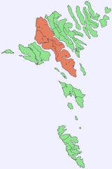
Streymoy is the largest and most populated island of the Faroe Islands
. The capital, Tórshavn
is located there. The name means "island of currents".
s in the Southeast: Kollafjørður
and Kaldbaksfjørður. The island is mountainous, especially in the Northwest, with the highest peak Kopsenni (789 metres (2,588.6 ft)). That area is dominated by over 500-metre high cliffs. The area is known as Vestmannabjørgini, which means Cliffs of Vestmanna
.
 Like the rest of the Faroe Islands
there are numerous short streams and minor lakes. The main vegetation is grass, with no trees. Some of the villages have planted trees inside or just outside the village. These parks need to have fence around them in order to keep sheep out.
Streymoy is separated from the nearby Eysturoy
, second largest island of the Faroe Islands
by the narrow sound of Sundini in the east. To the West lies the island of Vágar
, and to the South the island of Sandoy
. Three additional smaller islands are situated around the Southern tip of Streymoy: Koltur
, Hestur
and Nólsoy
.
. The majority of them reside in the capital Tórshavn
which has a population of about 20,000 in the municipality, of which 12,300 live in Tórshavn, 3,600 in Hoyvík
and 2,000 in Argir
, Hoyvík and Argir are suburbs of Tórshavn, but they have grown together. Around 1,200 peole live in Vestmanna
, 800 in Kollafjørður
. Besides being the seat of the government Tórshavn
is also the chief port, seat of the university and the commercial centre of the islands.
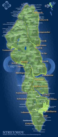
, the former ferry port in the West, Kollafjørður
at the centre and the picturesque villages of Saksun
and Tjørnuvík
in the North. From a historic point of view the village of Kirkjubøur
near the Southern tip of the island is very important as it was an episcopal center during the Middle Ages.
 All the settlements are connected by surfaced roads. The main entry road to Tórshavn
passes through a 2.8 kilometres (1.7 mi) long tunnel. The connection to the island Eysturoy
is via a bridge over the Sundini sound. Since 2002, a 4 kilometres (2.5 mi) long undersea tunnel connects Streymoy to Vágar
thereby completing the road connections of the three "mainland" islands.
Streymoy is connected by regular ferry service to the island of Sandoy
from the ferry port on Gamla Rætt near Kirkjubøur, and to the islands Suðuroy
and Nólsoy
from the ferry port in Tórshavn
. In summertime, scheduled ferry connects Tórshavn
with Hanstholm
in Denmark
and Seyðisfjörður
in Iceland
; the remainder of the year the ferry connects with Esbjerg
in Denmark. The closest airport is on Vágar
island, it is the only airport in the Faroe Islands.
Faroe Islands
The Faroe Islands are an island group situated between the Norwegian Sea and the North Atlantic Ocean, approximately halfway between Scotland and Iceland. The Faroe Islands are a self-governing territory within the Kingdom of Denmark, along with Denmark proper and Greenland...
. The capital, Tórshavn
Tórshavn
Tórshavn is the capital and largest town of the Faroe Islands. It is located in the southern part on the east coast of Streymoy. To the north west of the town lies the high mountain Húsareyn, and to the southwest, the high Kirkjubøreyn...
is located there. The name means "island of currents".
Geography
The island is oblong in shape and stretches roughly in Northwest-Southeast direction with a length of 47 kilometres (29.2 mi) and a width of around 10 kilometres (6.2 mi). There are two deeply indented fjordFjord
Geologically, a fjord is a long, narrow inlet with steep sides or cliffs, created in a valley carved by glacial activity.-Formation:A fjord is formed when a glacier cuts a U-shaped valley by abrasion of the surrounding bedrock. Glacial melting is accompanied by rebound of Earth's crust as the ice...
s in the Southeast: Kollafjørður
Kollafjørður
Kollafjørður is a village in the Faroe Islands located on the island of Streymoy at 62°7′6″N, 6°54′20″W with a population of 822. Its postal code is FO 410. It is part of the Tórshavnar municipality.-See also:* List of towns in the Faroe Islands...
and Kaldbaksfjørður. The island is mountainous, especially in the Northwest, with the highest peak Kopsenni (789 metres (2,588.6 ft)). That area is dominated by over 500-metre high cliffs. The area is known as Vestmannabjørgini, which means Cliffs of Vestmanna
Vestmanna
Vestmanna is a town in the Faroe Islands on the west of the island of Streymoy. It was formerly a ferry port, until an undersea tunnel was built from Vágar to Kvívík and Stykkið. The cliffs west of Vestmanna, Vestmannabjørgini are very popular for excursions by boat.A 'Vestmann' was a "Westman",...
.
Faroe Islands
The Faroe Islands are an island group situated between the Norwegian Sea and the North Atlantic Ocean, approximately halfway between Scotland and Iceland. The Faroe Islands are a self-governing territory within the Kingdom of Denmark, along with Denmark proper and Greenland...
there are numerous short streams and minor lakes. The main vegetation is grass, with no trees. Some of the villages have planted trees inside or just outside the village. These parks need to have fence around them in order to keep sheep out.
Streymoy is separated from the nearby Eysturoy
Eysturoy
Eysturoy means East island and is the second-largest of the Faroe Islands in the North Atlantic, both in size and population. It is separated by a narrow sound from the main island of Streymoy. Eysturoy is extremely rugged, with some 66 separate mountain peaks, including Slættaratindur, the...
, second largest island of the Faroe Islands
Faroe Islands
The Faroe Islands are an island group situated between the Norwegian Sea and the North Atlantic Ocean, approximately halfway between Scotland and Iceland. The Faroe Islands are a self-governing territory within the Kingdom of Denmark, along with Denmark proper and Greenland...
by the narrow sound of Sundini in the east. To the West lies the island of Vágar
Vágar
Vágar is one of the 18 islands in the archipelago of the Faroe Islands and the most westerly of the large islands. With a size of 178 km² , it ranks number three, behind Streymoy and Eysturoy....
, and to the South the island of Sandoy
Sandoy
Sandoy is a small island that is part of the Faroe Islands, an autonomous region of the Kingdom of Denmark. The largest population center on the island is the village of Sandur with a population of six hundred....
. Three additional smaller islands are situated around the Southern tip of Streymoy: Koltur
Koltur
Koltur is an island in the Faroe Islands, located to the west of Streymoy and to the north of Hestur. The island has just one settlement: Koltur. It was abandoned in the 1980s by the sheep-farmers whose flocks grazed on the southern part of the island. Since then only two people have returned , and...
, Hestur
Hestur
Hestur is an island in central Faroe Islands, located to the west of Streymoy and to the south of Koltur. Hestur means horse in Faroese. Located on the west coast is a large colony of guillemot. In the north of Hestur there is a moorland with four small lakes, of which Fagradalsvatn is the largest...
and Nólsoy
Nólsoy
Nólsoy is an island and village in central Faroe Islands, located to the east of the capital Tórshavn in Streymoy. There is only one settlement on the island: Nólsoy on the north-west coast on Stongin, a peninsula attached to the rest of the island by a metres-wide isthmus...
.
Population
There are about 22,400 inhabitants on the island, which represents more than 40% of the whole population of the Faroe IslandsFaroe Islands
The Faroe Islands are an island group situated between the Norwegian Sea and the North Atlantic Ocean, approximately halfway between Scotland and Iceland. The Faroe Islands are a self-governing territory within the Kingdom of Denmark, along with Denmark proper and Greenland...
. The majority of them reside in the capital Tórshavn
Tórshavn
Tórshavn is the capital and largest town of the Faroe Islands. It is located in the southern part on the east coast of Streymoy. To the north west of the town lies the high mountain Húsareyn, and to the southwest, the high Kirkjubøreyn...
which has a population of about 20,000 in the municipality, of which 12,300 live in Tórshavn, 3,600 in Hoyvík
Hoyvík
Hoyvík is the third largest town in the Faroe Islands. It has grown in size for many years and is now merged with Tórshavn becoming a northern suburb of the Faroese capital. A person from Hoyvík is known as a hoyvíkingur....
and 2,000 in Argir
Argir
Argir is a village in the Faroe Islands.*Population: 1907*Postal code . FO 160*Location: *Municipality: Tórshavnar kommuna*Football team: AB...
, Hoyvík and Argir are suburbs of Tórshavn, but they have grown together. Around 1,200 peole live in Vestmanna
Vestmanna
Vestmanna is a town in the Faroe Islands on the west of the island of Streymoy. It was formerly a ferry port, until an undersea tunnel was built from Vágar to Kvívík and Stykkið. The cliffs west of Vestmanna, Vestmannabjørgini are very popular for excursions by boat.A 'Vestmann' was a "Westman",...
, 800 in Kollafjørður
Kollafjørður
Kollafjørður is a village in the Faroe Islands located on the island of Streymoy at 62°7′6″N, 6°54′20″W with a population of 822. Its postal code is FO 410. It is part of the Tórshavnar municipality.-See also:* List of towns in the Faroe Islands...
. Besides being the seat of the government Tórshavn
Tórshavn
Tórshavn is the capital and largest town of the Faroe Islands. It is located in the southern part on the east coast of Streymoy. To the north west of the town lies the high mountain Húsareyn, and to the southwest, the high Kirkjubøreyn...
is also the chief port, seat of the university and the commercial centre of the islands.
Towns and villages
The other important towns include: VestmannaVestmanna
Vestmanna is a town in the Faroe Islands on the west of the island of Streymoy. It was formerly a ferry port, until an undersea tunnel was built from Vágar to Kvívík and Stykkið. The cliffs west of Vestmanna, Vestmannabjørgini are very popular for excursions by boat.A 'Vestmann' was a "Westman",...
, the former ferry port in the West, Kollafjørður
Kollafjørður
Kollafjørður is a village in the Faroe Islands located on the island of Streymoy at 62°7′6″N, 6°54′20″W with a population of 822. Its postal code is FO 410. It is part of the Tórshavnar municipality.-See also:* List of towns in the Faroe Islands...
at the centre and the picturesque villages of Saksun
Saksun
Saksun is a village near the north-west coast of the Faroese island of Streymoy.*Population: 34*Postal code : FO 436*Location: *Municipality: Saksunar...
and Tjørnuvík
Tjørnuvík
Tjørnuvík is the northernmost village on the Faroese island of Streymoy in the Sunda Kommuna municipality. The 2002 population was 64. Its postal code is FO 445. Its current church was built in 1937.-External links:*-See also:...
in the North. From a historic point of view the village of Kirkjubøur
Kirkjubøur
Kirkjubøur is the southernmost village on Streymoy, Faroe Islands and the country's most important historical site.It is located on the west coast and has a view towards the islands Hestur and Koltur.-History:...
near the Southern tip of the island is very important as it was an episcopal center during the Middle Ages.
Transportation
Tórshavn
Tórshavn is the capital and largest town of the Faroe Islands. It is located in the southern part on the east coast of Streymoy. To the north west of the town lies the high mountain Húsareyn, and to the southwest, the high Kirkjubøreyn...
passes through a 2.8 kilometres (1.7 mi) long tunnel. The connection to the island Eysturoy
Eysturoy
Eysturoy means East island and is the second-largest of the Faroe Islands in the North Atlantic, both in size and population. It is separated by a narrow sound from the main island of Streymoy. Eysturoy is extremely rugged, with some 66 separate mountain peaks, including Slættaratindur, the...
is via a bridge over the Sundini sound. Since 2002, a 4 kilometres (2.5 mi) long undersea tunnel connects Streymoy to Vágar
Vágar
Vágar is one of the 18 islands in the archipelago of the Faroe Islands and the most westerly of the large islands. With a size of 178 km² , it ranks number three, behind Streymoy and Eysturoy....
thereby completing the road connections of the three "mainland" islands.
Streymoy is connected by regular ferry service to the island of Sandoy
Sandoy
Sandoy is a small island that is part of the Faroe Islands, an autonomous region of the Kingdom of Denmark. The largest population center on the island is the village of Sandur with a population of six hundred....
from the ferry port on Gamla Rætt near Kirkjubøur, and to the islands Suðuroy
Suðuroy
Suðuroy is the southernmost of the Faroe Islands. The island covers 163.7 km². In 2010 there were 4763 inhabitants, but there has been a gradual decline in the population numbers ever since the 1950s....
and Nólsoy
Nólsoy
Nólsoy is an island and village in central Faroe Islands, located to the east of the capital Tórshavn in Streymoy. There is only one settlement on the island: Nólsoy on the north-west coast on Stongin, a peninsula attached to the rest of the island by a metres-wide isthmus...
from the ferry port in Tórshavn
Tórshavn
Tórshavn is the capital and largest town of the Faroe Islands. It is located in the southern part on the east coast of Streymoy. To the north west of the town lies the high mountain Húsareyn, and to the southwest, the high Kirkjubøreyn...
. In summertime, scheduled ferry connects Tórshavn
Tórshavn
Tórshavn is the capital and largest town of the Faroe Islands. It is located in the southern part on the east coast of Streymoy. To the north west of the town lies the high mountain Húsareyn, and to the southwest, the high Kirkjubøreyn...
with Hanstholm
Hanstholm
Hanstholm is a small town and a former island, now elevated area in Thisted municipality of Region Nordjylland, located in the northern part of Denmark. Coordinates:...
in Denmark
Denmark
Denmark is a Scandinavian country in Northern Europe. The countries of Denmark and Greenland, as well as the Faroe Islands, constitute the Kingdom of Denmark . It is the southernmost of the Nordic countries, southwest of Sweden and south of Norway, and bordered to the south by Germany. Denmark...
and Seyðisfjörður
Seyðisfjörður
Seyðisfjörður is a town and municipality in the Eastfjords of Iceland at the innermost point of the fjord of the same name.As of January 2011, the town has 668 inhabitants....
in Iceland
Iceland
Iceland , described as the Republic of Iceland, is a Nordic and European island country in the North Atlantic Ocean, on the Mid-Atlantic Ridge. Iceland also refers to the main island of the country, which contains almost all the population and almost all the land area. The country has a population...
; the remainder of the year the ferry connects with Esbjerg
Esbjerg
Esbjerg Municipality is a municipality in Region of Southern Denmark on the west coast of the Jutland peninsula in southwest Denmark. Its mayor is Johnny Søtrup, from the Venstre political party...
in Denmark. The closest airport is on Vágar
Vágar
Vágar is one of the 18 islands in the archipelago of the Faroe Islands and the most westerly of the large islands. With a size of 178 km² , it ranks number three, behind Streymoy and Eysturoy....
island, it is the only airport in the Faroe Islands.
External links
- The Tourist Information of Tórshavn and Streymoy
- personal website with 25 aerial photos of Streymoy
- Photos from Streymoy on Flickr.com