
Vágar
Encyclopedia
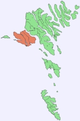
Vágar is one of the 18 islands in the archipelago of the Faroe Islands
and the most westerly of the large islands. With a size of 178 km² (about 70 sq. miles), it ranks number three, behind Streymoy
and Eysturoy
.
The shape of the island is very distinct, since it resembles a dog's head. Sørvágsfjørður
is the mouth and Fjallavatn
is the eye.
. An airfield was built there during World War II
by the British, who occupied the Faroe Islands in a friendly manner. After the war it lay unused for about 20 years, but was then put back into service and expanded/modernised as required. It handles about 170,000 passengers a year. Such large numbers by Faroese standards put a considerable strain on transport facilities, with the result that a road tunnel (Vágatunnilin) measuring 5 km in length and running under the sea now connects Vágar with the two largest islands in the Faroes and therefore the capital Tórshavn
.
and Fjallavatn
- are to be found there, and the tourist association organises excursions throughout the summer.
 Vágar has three large villages and three small ones, but a hundred years ago there were seven.
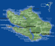
The largest is Miðvágur
, which has 1025 inhabitants (2003). It is in the middle of the island and so has naturally become a centre, with a police station, doctor’s surgery, co-op and vicarage. It is also a historic village and was home to Beinta Broberg
, a clergyman’s wife who was dubbed “Wicked Beinta”. Jørgen Frantz Jacobsen told the story of her life in his famous novel “Barbara” by Jørgen-Frantz Jacobsen
, which was filmed in 1997 by Niels Malmros. The farmhouse, Kálvalíð to the north is the oldest house in the village and possibly in the Faroe Islands too. It is now the village museum.
To the east of Miðvágur lies Sandavágur
, which has a population of 716 (2003). It too is a historic village. It was home to the law speaker of the Faroe Islands until 1816, when the office was abolished and the islands became a Danish administrative district. The clergyman V. U. Hammershaimb, who was born in Sandavágur in 1819 and became the father of the Faroese written language
, was the son of the last law speaker.
The Sandavágur stone
with a runic inscription dating back to around 1200 was found there in 1917 and can now be seen in the Sandavágur church.
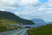
The third large village is Sørvágur
, which is on the western side of the island, near the airport, and has 980 inhabitants (2003). During World War II, when the airfield was being built in 1942-1944, 5,000 British soldiers lived in Sørvágur, but now few traces remain of their camp to the south of the village. Tindhólmur
, Gáshólmur
and the two “drangar” (freestanding cliffs) belong to the village. The view out to them is among the most beautiful in the Faroe Islands.
Vágar has two other old villages: Bøur
, which lies 4 km west of Sørvágur and has 69 inhabitants (2003), and Gásadalur
, which lies further west on Mykines Fjord and has just 16 inhabitants (2003). Many people have moved away from this village, but it now has a road link in the form of a tunnel through the mountain and it is hoped that the village will start to grow again.
A new village, Vatnsoyrar
, which has 41 inhabitants, appeared on Vágar in 1921. It was founded by three men, each of whom was given a plot of land to farm and set up home there with his family. The village is in the upland pastures belonging to Miðvágur and so forms part of Miðvágur District. When the British occupied the Faroe Islands and built the airfield on Vágar, Vatnsoyrar was their headquarters. The local population was evacuated, but was able to return home when the war ended.
At the northernmost point of the island, in the upland pastures belonging to Sandavágur, lay the village of Slættanes
, which was founded in 1835. It grew for a time and at its largest was home to around 70 people. It also had a school, which can be seen on the left on the stamp. The last residents left in 1964.
Another new village, Víkar
, was founded in the upland pastures belonging to Gásadalur on the north side of the island in 1833. The area was good for farming, but the settlement was very isolated, and getting to the next village was a difficult business. The last few inhabitants moved away in 1910.
The Kvígandalsá river's beautiful little bridge forms part of a road that was built to facilitate peat cutting.
If you carry on along this road and then follow the path through the valley, you arrive at Fjallavatn
lake. There are no motorways or other modern conveniences, but you can enjoy the tranquillity, which is accentuated by the murmuring of the river, the lapping of the waves and the twittering of the birds.
Faroe Islands
The Faroe Islands are an island group situated between the Norwegian Sea and the North Atlantic Ocean, approximately halfway between Scotland and Iceland. The Faroe Islands are a self-governing territory within the Kingdom of Denmark, along with Denmark proper and Greenland...
and the most westerly of the large islands. With a size of 178 km² (about 70 sq. miles), it ranks number three, behind Streymoy
Streymoy
Streymoy is the largest and most populated island of the Faroe Islands. The capital, Tórshavn is located there. The name means "island of currents".- Geography :...
and Eysturoy
Eysturoy
Eysturoy means East island and is the second-largest of the Faroe Islands in the North Atlantic, both in size and population. It is separated by a narrow sound from the main island of Streymoy. Eysturoy is extremely rugged, with some 66 separate mountain peaks, including Slættaratindur, the...
.
The shape of the island is very distinct, since it resembles a dog's head. Sørvágsfjørður
Sørvágsfjørður
Sørvágsfjørður is a fjord on the west-side of the island Vágoy in the Faroe Islands which is approximately long.At the end of the fjord lies the village of Sørvágur. On the northside of the fjord lies the small village Bøur. On the southside of the fjord lies the picturesque Tindhólmur flanked by...
is the mouth and Fjallavatn
Fjallavatn
Fjallavatn is the second largest lake in the Faroe Islands. It is situated on the island of Vágar and its size is 1 km2....
is the eye.
History
Vágar is the first port of call for most foreigners travelling to the Faroe Islands, as it is home to the islands’ only airport, Vágar AirportVágar Airport
Vágar Airport is the only airport in the Faroe Islands, a self-governing territory of the Kingdom of Denmark, and is located east of Sørvágur. Due to the Faroe Islands' rather anomalous status, the airport is not fully subject to the rules of the European Union...
. An airfield was built there during World War II
World War II
World War II, or the Second World War , was a global conflict lasting from 1939 to 1945, involving most of the world's nations—including all of the great powers—eventually forming two opposing military alliances: the Allies and the Axis...
by the British, who occupied the Faroe Islands in a friendly manner. After the war it lay unused for about 20 years, but was then put back into service and expanded/modernised as required. It handles about 170,000 passengers a year. Such large numbers by Faroese standards put a considerable strain on transport facilities, with the result that a road tunnel (Vágatunnilin) measuring 5 km in length and running under the sea now connects Vágar with the two largest islands in the Faroes and therefore the capital Tórshavn
Tórshavn
Tórshavn is the capital and largest town of the Faroe Islands. It is located in the southern part on the east coast of Streymoy. To the north west of the town lies the high mountain Húsareyn, and to the southwest, the high Kirkjubøreyn...
.
Tourism
The tourist attractions on Vágar are excellent and perhaps the best in the Faroe Islands. The country’s two largest lakes - SørvágsvatnSørvágsvatn
Sørvágsvatn is the biggest lake of the Faroe Islands. It is situated on the island of Vágar between the municipalities of Sørvágs Kommuna and Miðvágs kommuna...
and Fjallavatn
Fjallavatn
Fjallavatn is the second largest lake in the Faroe Islands. It is situated on the island of Vágar and its size is 1 km2....
- are to be found there, and the tourist association organises excursions throughout the summer.
Villages
The largest is Miðvágur
Miðvágur
Miðvágur is a village in the Faroe Islands on Vágar. It has been a municipality until 1 January, 2009 when it fused with Sandavágur into Vága kommuna.Located on the south coast of the island of Vágar, Miðvágur is the largest town on this Faroese island...
, which has 1025 inhabitants (2003). It is in the middle of the island and so has naturally become a centre, with a police station, doctor’s surgery, co-op and vicarage. It is also a historic village and was home to Beinta Broberg
Beinta Broberg
Bente Christine Broberg, known as Beinta Broberg, , is perhaps the best known woman from the history of the Faroe Islands...
, a clergyman’s wife who was dubbed “Wicked Beinta”. Jørgen Frantz Jacobsen told the story of her life in his famous novel “Barbara” by Jørgen-Frantz Jacobsen
Jørgen-Frantz Jacobsen
Jørgen-Frantz Jacobsen occupies a distinct place in Scandinavian literature. He is the only Faroese writer to achieve international best-seller status...
, which was filmed in 1997 by Niels Malmros. The farmhouse, Kálvalíð to the north is the oldest house in the village and possibly in the Faroe Islands too. It is now the village museum.
To the east of Miðvágur lies Sandavágur
Sandavágur
The town of Sandavágur lies on the south coast of the Faroese island of Vágar, and has been voted the most well-kept village in the Faroes twice. The name Sandavágur means sandy creek and refers to the beach down by the inlet. From one point in Sandavágur you can get a view of all the southern...
, which has a population of 716 (2003). It too is a historic village. It was home to the law speaker of the Faroe Islands until 1816, when the office was abolished and the islands became a Danish administrative district. The clergyman V. U. Hammershaimb, who was born in Sandavágur in 1819 and became the father of the Faroese written language
Faroese language
Faroese , is an Insular Nordic language spoken by 48,000 people in the Faroe Islands and about 25,000 Faroese people in Denmark and elsewhere...
, was the son of the last law speaker.
The Sandavágur stone
Sandavágur stone
The Sandavágur stone is a runestone that was discovered in the town of Sandavágur on the Faroe Islands in 1917. The stone can today be seen in the Sandavágur Church....
with a runic inscription dating back to around 1200 was found there in 1917 and can now be seen in the Sandavágur church.
The third large village is Sørvágur
Sørvágur
Sørvágur is a village on the island of Vágoy in the Faroe Islands. It is located at the landward end of Sørvágsfjørður. Sørvágur is the largest village in the municipality of Sørvágs Kommuna.-Name:...
, which is on the western side of the island, near the airport, and has 980 inhabitants (2003). During World War II, when the airfield was being built in 1942-1944, 5,000 British soldiers lived in Sørvágur, but now few traces remain of their camp to the south of the village. Tindhólmur
Tindhólmur
Tindhólmur is an islet on the southside of Sørvágsfjørður, west of Vágar in the Faroe Islands. It has its name from the five peaks, which are named Ytsti, Arni, Lítli, Breiði, Bogdi...
, Gáshólmur
Gáshólmur
Gáshólmur is a small islet on the southside of Sørvágsfjørður in the Faroe Islands. To the east of the islet lies another islet, Tindhólmur. The islet is uninhabited, and the only living creatures are seabirds and sheep rams, which are placed on the islet each year by the locals in Sørvágur.*...
and the two “drangar” (freestanding cliffs) belong to the village. The view out to them is among the most beautiful in the Faroe Islands.
Vágar has two other old villages: Bøur
Bøur
Bøur is a village in the Sørvágs Kommuna of the Faroe Islands, 4 km west of Sørvágur, with a population of 70 . Its location is and its postal code is FO 386....
, which lies 4 km west of Sørvágur and has 69 inhabitants (2003), and Gásadalur
Gásadalur
Gásadalur is located on the west-side of Vágar, Faroe Islands, and enjoys a panoramic view over the island of Mykines.Gásadalur is located on the edge of Mykinesfjørður, surrounded by the highest mountains on Vágar. Árnafjall towers to a height of 722 metres to the north, and Eysturtindur to the...
, which lies further west on Mykines Fjord and has just 16 inhabitants (2003). Many people have moved away from this village, but it now has a road link in the form of a tunnel through the mountain and it is hoped that the village will start to grow again.
A new village, Vatnsoyrar
Vatnsoyrar
Vatnsoyrar is a village founded in 1921 in the middle of the Faroese island of Vagar.Vatnsoyrar, being created in 1921, is one of the youngest settlements in the Faroes. It is the only village in the archipelago that is not on the coast, but instead it is next to Sørvagsvatn, the largest lake on...
, which has 41 inhabitants, appeared on Vágar in 1921. It was founded by three men, each of whom was given a plot of land to farm and set up home there with his family. The village is in the upland pastures belonging to Miðvágur and so forms part of Miðvágur District. When the British occupied the Faroe Islands and built the airfield on Vágar, Vatnsoyrar was their headquarters. The local population was evacuated, but was able to return home when the war ended.
At the northernmost point of the island, in the upland pastures belonging to Sandavágur, lay the village of Slættanes
Slættanes
Slættanes is a town on the Island of Vágar in the Faroes, which is now abandoned.Slættanes, like the also abandoned village of Víkar, on the northern coast of the island. It was founded in 1835 by a man named Hendrik Thomasen and belonged to the municipality of Sandavágur in the south...
, which was founded in 1835. It grew for a time and at its largest was home to around 70 people. It also had a school, which can be seen on the left on the stamp. The last residents left in 1964.
Another new village, Víkar
Víkar, Faroe Islands
Víkar is an abandoned town in the Faroe Islands on the north coast of the Island of Vágar.Víkar was founded in 1833 and belonged to the village of Gásadalur farther south. Even today a path still connects the two communities with each other. Even though the landscape was very favorable, Víkar had...
, was founded in the upland pastures belonging to Gásadalur on the north side of the island in 1833. The area was good for farming, but the settlement was very isolated, and getting to the next village was a difficult business. The last few inhabitants moved away in 1910.
The Kvígandalsá river's beautiful little bridge forms part of a road that was built to facilitate peat cutting.
If you carry on along this road and then follow the path through the valley, you arrive at Fjallavatn
Fjallavatn
Fjallavatn is the second largest lake in the Faroe Islands. It is situated on the island of Vágar and its size is 1 km2....
lake. There are no motorways or other modern conveniences, but you can enjoy the tranquillity, which is accentuated by the murmuring of the river, the lapping of the waves and the twittering of the birds.
Mountains
The 41 mountains on Vágar, the major ones are:| Name | Height |
|---|---|
| Árnafjall Árnafjall Árnafjall is the highest mountain on the island of Vágar in the Faroe Islands. The highest point is 722 meters above sea level. The name Árnafjall translates to the eagles mountain. The mountain lies on the west side of Vágar close to the village of Gásadalur.There is also a mountain Árnafjall on... |
722 m |
| Eysturtindur Eysturtindur Eysturtindur is the second highest point - 714 m - on the island of Vágoy, Faroe Islands.... |
714 m |
| Húsafelli |
Major lakes
| Name | Area |
|---|---|
| Sørvágsvatn Sørvágsvatn Sørvágsvatn is the biggest lake of the Faroe Islands. It is situated on the island of Vágar between the municipalities of Sørvágs Kommuna and Miðvágs kommuna... |
3.4 km² |
| Fjallavatn Fjallavatn Fjallavatn is the second largest lake in the Faroe Islands. It is situated on the island of Vágar and its size is 1 km2.... |
1.02 km² |
| Vatnsdalsvatn | |
| Kvilkinnavatn |
Islets and rocks in the sea
- TindhólmurTindhólmurTindhólmur is an islet on the southside of Sørvágsfjørður, west of Vágar in the Faroe Islands. It has its name from the five peaks, which are named Ytsti, Arni, Lítli, Breiði, Bogdi...
- GáshólmurGáshólmurGáshólmur is a small islet on the southside of Sørvágsfjørður in the Faroe Islands. To the east of the islet lies another islet, Tindhólmur. The islet is uninhabited, and the only living creatures are seabirds and sheep rams, which are placed on the islet each year by the locals in Sørvágur.*...
- SkerhólmurSkerhólmurSkerhólmur is a small islet in the middle of Sørvágsfjørður on the island of Vágar, Faroe Islands.It is uninhabited....
- Trøllkonufingur
- Dunnusdrangar
- Filpusardrangur
- DrangarnirDrangarnirDrangarnir is the collective name for two sea stacks between the islet Tindhólmur and the island Vágar in the Faroe Islands. The individual names of the sea stacks are Stóri Drangur and Lítli Drangur ....
- Lítli Drangur, Stóri Drangur
External links
- Stamps.fo (public domain by Postverk FøroyaPostverk FøroyaPosta is the postal service of the Faroe Islands and was founded on 1 April 1976 under the Home Rule of the Faroe Islands. On 16 December 2005, it became a public joint stock company under the name P/F Postverk Føroya ....
) - Personal website with 78 aerial photos of Vágar