
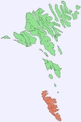
Suðuroy
Encyclopedia
Faroe Islands
The Faroe Islands are an island group situated between the Norwegian Sea and the North Atlantic Ocean, approximately halfway between Scotland and Iceland. The Faroe Islands are a self-governing territory within the Kingdom of Denmark, along with Denmark proper and Greenland...
. The island covers 163.7 km². In 2010 there were 4763 inhabitants, but there has been a gradual decline in the population numbers ever since the 1950s.
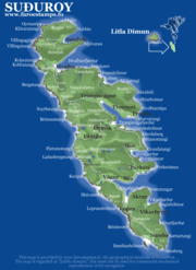
These are the settlements of Suðuroy (listed from north to south): Sandvík
Sandvík
Sandvík is the northernmost village of the island of Suðuroy in the Faroe Islands. It is situated on the northern side of a shallow fjord. The small village was earlier known as Hvalvík until 1913...
(re-established as a settlement in the early 19th century) Hvalba
Hvalba
Hvalba is a village and a municipality, which consists of Hvalba, Nes-Hvalba and Sandvík. The total population of Hvalba Municipality was 723 as of 1 January 2010; the population of Hvalba and Nes was 626 and the population of Sandvík was 97. Hvalba is one of the larger villages in the Faroe...
, Froðba
Froðba
Froðba is a village located farthest out on the north brink of Trongisvágsfjørður, an inlet on the east coast of the island of Suðuroy in the Faroe Islands. The village has eventually merged with the harbour-city of Tvøroyri....
, Tvøroyri
Tvøroyri
Tvøroyri lies picturesquely on the north side of the Trongisvágsfjørður on the east coast of Suðuroy, Faroe Islands....
, Trongisvágur
Trongisvágur
Trongisvágur is a village on the island of Suduroy in the Faroe Islands.*Population: 415*Postal code : FO 826*Location: *Municipality: Tvoroyrar...
, Øravík
Øravík
Øravík is a village on the east coast of the island of Suðuroy in the Faroe Islands. The village is located in the center of the island on a crossroad where the road to Fámjin goes towards west over the mountains to the west coast. One part of the village is located in the bay of Øravík, the other...
, Fámjin
Fámjin
Fámjin is a village, located in the middle of the coastline on the western side of Suðuroy, the southernmost island in Faroe Islands. It has a population of around 100....
, Hov
Hov, Faroe Islands
*Population: 133*Postal code : FO 960*Location: *Municipality: HovsHov is a village located on Suduroy’s east coast, in the Faroe Islands; it is frequently mentioned in the country's history. Salmon sea farming has been practiced in Hov since the 1980’s...
, Porkeri
Porkeri
Porkeri is a village in the Faroe Islands, situated north of Vágur on Suðuroy's east coast. As of 2004 it had a population of 332. and has been inhabited at least as early as the 14th century....
, Vágur
Vágur
Vágur meaning Bay is a town on the Faroe Islands of Suðuroy, it is situated on the east coast of the island on the Vágsfjørður fjord, and dates from the fourteenth century. Expansion has meant that the nearby town of Nes is now a suburb of Vágur...
, Fámara (re-established in 2010), Akrar
Akrar
Akrar is a village in the Faroe Islands. It is located on Lopransfjørður, an inlet, which itself is part of Vágsfjørður, on the east-side of Suðuroy, and was founded in the year 1817.-External links:...
, Lopra
Lopra
Lopra is a village on the island of Suðuroy with the postal code FO 926. In 2009 its population was 96. It is located in the Municipality of Sumba along with the villages Akrar, Sumba and Víkarbyrgi, constituting the southernmost settlements in the Faroe Islands...
and Sumba
Sumba, Faroe Islands
Sumba is the southernmost place of the Faroe Islands on the island of Suðuroy. It is located in the Sumbiar municipality.The municipality has 385 inhabitants. 258 of these people are living in Sumba. The other villages in the Municipality of Sumba are: Lopra , Akrar , Víkarbyrgi .Sumba is known for...
.
One ancient settlement Víkarbyrgi
Víkarbyrgi
Víkarbyrgi is a former village on the Faroese island of Suðuroy, Faroe Islands. It no longer has a population. It retains a postal code and is located at N 61° 26' 34 W 6° 43' 28. The etymology of its name is reputed to be connected with an early settlement of Irish monks who predated the arrival...
was abandoned late in the 1990s. Another settlement Akraberg
Akraberg
Akraberg is the southern tip of Suðuroy, 5 km south from the village Sumba, Faroe Islands. The name Akraberg derives from akur . Five kilometres south of Akraberg is the southernmost point of The Faroe Islands, a rock called Munkurin , also called Sumbiarsteinur, which is one of a group of six...
was abandoned around 1350 because of the black death, the people who lived there at that time came from Friesland
Friesland
Friesland is a province in the north of the Netherlands and part of the ancient region of Frisia.Until the end of 1996, the province bore Friesland as its official name. In 1997 this Dutch name lost its official status to the Frisian Fryslân...
, and legend has it that people in Hørg (in Sumba) can trace their ancestry back to this settlement, which was situated on the southernmost point of the island.
Two more settlement were started in early and mid 20th century: Botni north west of Vágur
Vágur
Vágur meaning Bay is a town on the Faroe Islands of Suðuroy, it is situated on the east coast of the island on the Vágsfjørður fjord, and dates from the fourteenth century. Expansion has meant that the nearby town of Nes is now a suburb of Vágur...
and Tjaldavík in a bay south east of Øravík, but both have been abandoned again.
Geography
The highest point of Suðuroy is the mountain GluggarnirGluggarnir
Gluggarnir is a mountain in the Faroe Islands. At 610 metres, it is the highest mountain on the southernmost island Suðuroy. The mountain is located between the villages Fámjin and Trongisvágur....
(610 m), but the most famous peak is definitely the mountain of Beinisvørð
Beinisvørð
Beinisvørð is a 470 meter high sea cliff in Suðuroy, Faroe Islands, the highest sea cliff in Suðuroy. It is located between the villages of Lopra and Sumba. Beinisvørð has vertical cliffs facing the sea and a green slope down towards the village of Sumba...
west of the village of Sumba
Sumba, Faroe Islands
Sumba is the southernmost place of the Faroe Islands on the island of Suðuroy. It is located in the Sumbiar municipality.The municipality has 385 inhabitants. 258 of these people are living in Sumba. The other villages in the Municipality of Sumba are: Lopra , Akrar , Víkarbyrgi .Sumba is known for...
. The Beinisvørð and its beauty has been praised by the local poet Poul F. Joensen (1898–1970) as well as other Faroese poets. Suðuroy is the island which has most islets and skerries. Suðuroy and the islets and skerries near the island are 263 including the island itself.
Tourism
Visitors to Suðuroy travel by the ferry Smyril M/S from TórshavnTórshavn
Tórshavn is the capital and largest town of the Faroe Islands. It is located in the southern part on the east coast of Streymoy. To the north west of the town lies the high mountain Húsareyn, and to the southwest, the high Kirkjubøreyn...
. The crossing takes about two hours and if the weather and the trip is recognised as attractive. There are scenic views of nine of the total of eighteen islands that make up the Faroese archipelago. They are in the following order from north to south: Streymoy
Streymoy
Streymoy is the largest and most populated island of the Faroe Islands. The capital, Tórshavn is located there. The name means "island of currents".- Geography :...
, Nólsoy
Nólsoy
Nólsoy is an island and village in central Faroe Islands, located to the east of the capital Tórshavn in Streymoy. There is only one settlement on the island: Nólsoy on the north-west coast on Stongin, a peninsula attached to the rest of the island by a metres-wide isthmus...
, Hestur
Hestur
Hestur is an island in central Faroe Islands, located to the west of Streymoy and to the south of Koltur. Hestur means horse in Faroese. Located on the west coast is a large colony of guillemot. In the north of Hestur there is a moorland with four small lakes, of which Fagradalsvatn is the largest...
, Koltur
Koltur
Koltur is an island in the Faroe Islands, located to the west of Streymoy and to the north of Hestur. The island has just one settlement: Koltur. It was abandoned in the 1980s by the sheep-farmers whose flocks grazed on the southern part of the island. Since then only two people have returned , and...
, Sandoy
Sandoy
Sandoy is a small island that is part of the Faroe Islands, an autonomous region of the Kingdom of Denmark. The largest population center on the island is the village of Sandur with a population of six hundred....
, Skúvoy
Skúvoy
Skúvoy is an island in central Faroe Islands, located to the south of Sandoy. It is named after the large number of skua present on the island . There is only one settlement on the island: Skúvoy on the east coast...
, Stóra Dímun
Stóra Dímun
Stóra Dímun is an island in the southern Faroe Islands, sometimes only referred to as Dímun. The island is accessible from sea only during periods of clear and calm weather, but regular helicopter service is available twice a week through the whole year....
, Lítla Dímun
Lítla Dímun
Lítla Dímun is a small island between the islands of Suðuroy and Stóra Dímun in the Faroe Islands. It is the smallest of the main 18 islands, being less than in area, and is the only uninhabited one...
and Suðuroy.
As one travels past the two Dimun islands, the coastline of Suðuroy is in the background.
It is possible to go by bus from the harbour of Krambatangi
Krambatangi
Krambatangi is the ferry port of Suðuroy in the Faroe Islands. The ferry Smyril M/F disembarks 2-3 times daily from Krambatangi to Tórshavn. Krambatangi is located on the southern side of Trongisvágsfjørður halfway between Trongisvágur and Øravík, opposite of Tvøroyri. The ferry port was earlier on...
to Tvøroyri
Tvøroyri
Tvøroyri lies picturesquely on the north side of the Trongisvágsfjørður on the east coast of Suðuroy, Faroe Islands....
, Hvalba
Hvalba
Hvalba is a village and a municipality, which consists of Hvalba, Nes-Hvalba and Sandvík. The total population of Hvalba Municipality was 723 as of 1 January 2010; the population of Hvalba and Nes was 626 and the population of Sandvík was 97. Hvalba is one of the larger villages in the Faroe...
and Sandvík
Sandvík
Sandvík is the northernmost village of the island of Suðuroy in the Faroe Islands. It is situated on the northern side of a shallow fjord. The small village was earlier known as Hvalvík until 1913...
in the north on route 701 or to Vágur
Vágur
Vágur meaning Bay is a town on the Faroe Islands of Suðuroy, it is situated on the east coast of the island on the Vágsfjørður fjord, and dates from the fourteenth century. Expansion has meant that the nearby town of Nes is now a suburb of Vágur...
and all the other villages in the southern part of the island, Sumba
Sumba, Faroe Islands
Sumba is the southernmost place of the Faroe Islands on the island of Suðuroy. It is located in the Sumbiar municipality.The municipality has 385 inhabitants. 258 of these people are living in Sumba. The other villages in the Municipality of Sumba are: Lopra , Akrar , Víkarbyrgi .Sumba is known for...
being the southernmost and the terminus of route 700.
From Tvøroyri there is an attractive walk across the mountains to a valley called Hvannhagi. There is a view over the valley and Lítla Dímun
Lítla Dímun
Lítla Dímun is a small island between the islands of Suðuroy and Stóra Dímun in the Faroe Islands. It is the smallest of the main 18 islands, being less than in area, and is the only uninhabited one...
and the sea from above the valley.
From Tvøroyri
Tvøroyri
Tvøroyri lies picturesquely on the north side of the Trongisvágsfjørður on the east coast of Suðuroy, Faroe Islands....
one can follow the coast street over the mountains to Øravík
Øravík
Øravík is a village on the east coast of the island of Suðuroy in the Faroe Islands. The village is located in the center of the island on a crossroad where the road to Fámjin goes towards west over the mountains to the west coast. One part of the village is located in the bay of Øravík, the other...
and then there are three options. One can turn right to Fámjin
Fámjin
Fámjin is a village, located in the middle of the coastline on the western side of Suðuroy, the southernmost island in Faroe Islands. It has a population of around 100....
, or one can continue straight ahead and take the tunnel to Hov
Hov
Hov can refer to the following:*An HOV or High-occupancy vehicle*A location:**Hov, Faroe Islands**Hov, Norway*HOV, the ticker symbol for U.S...
, or take the old mountain road to Hov. After either of these two options you come to Hov and from there one can continue to the villages, Porkeri
Porkeri
Porkeri is a village in the Faroe Islands, situated north of Vágur on Suðuroy's east coast. As of 2004 it had a population of 332. and has been inhabited at least as early as the 14th century....
, Nes
Nes, Vágur
Nes is a village on the Faroese island of Suðuroy located in the municipality of Vágur . It is located west of Porkeri and east of Vágur. Its postal code is FO 925. It should not be confused with another village by the same name on Eysturoy . There is another village in Suðuroy with the same...
, Vágur
Vágur
Vágur meaning Bay is a town on the Faroe Islands of Suðuroy, it is situated on the east coast of the island on the Vágsfjørður fjord, and dates from the fourteenth century. Expansion has meant that the nearby town of Nes is now a suburb of Vágur...
, Lopra
Lopra
Lopra is a village on the island of Suðuroy with the postal code FO 926. In 2009 its population was 96. It is located in the Municipality of Sumba along with the villages Akrar, Sumba and Víkarbyrgi, constituting the southernmost settlements in the Faroe Islands...
, Akrar
Akrar
Akrar is a village in the Faroe Islands. It is located on Lopransfjørður, an inlet, which itself is part of Vágsfjørður, on the east-side of Suðuroy, and was founded in the year 1817.-External links:...
and from Lopra you can either take the road tunnel to Sumba or you can take the old curvy mountain road, which passes by the sea cliff Beinisvørð
Beinisvørð
Beinisvørð is a 470 meter high sea cliff in Suðuroy, Faroe Islands, the highest sea cliff in Suðuroy. It is located between the villages of Lopra and Sumba. Beinisvørð has vertical cliffs facing the sea and a green slope down towards the village of Sumba...
, than continue to Akraberg
Akraberg
Akraberg is the southern tip of Suðuroy, 5 km south from the village Sumba, Faroe Islands. The name Akraberg derives from akur . Five kilometres south of Akraberg is the southernmost point of The Faroe Islands, a rock called Munkurin , also called Sumbiarsteinur, which is one of a group of six...
with the lighthouse and to the southernmost village Sumba
Sumba, Faroe Islands
Sumba is the southernmost place of the Faroe Islands on the island of Suðuroy. It is located in the Sumbiar municipality.The municipality has 385 inhabitants. 258 of these people are living in Sumba. The other villages in the Municipality of Sumba are: Lopra , Akrar , Víkarbyrgi .Sumba is known for...
. As mentioned above, one can also turn right from the village Øravík
Øravík
Øravík is a village on the east coast of the island of Suðuroy in the Faroe Islands. The village is located in the center of the island on a crossroad where the road to Fámjin goes towards west over the mountains to the west coast. One part of the village is located in the bay of Øravík, the other...
and follow the road over the mountain to the little village Fámjin
Fámjin
Fámjin is a village, located in the middle of the coastline on the western side of Suðuroy, the southernmost island in Faroe Islands. It has a population of around 100....
, which is one of two villages on the west coast of Suðuroy, Sumba
Sumba, Faroe Islands
Sumba is the southernmost place of the Faroe Islands on the island of Suðuroy. It is located in the Sumbiar municipality.The municipality has 385 inhabitants. 258 of these people are living in Sumba. The other villages in the Municipality of Sumba are: Lopra , Akrar , Víkarbyrgi .Sumba is known for...
is the other one. All the other villages are located on the east coast. There is a road tunnel between Øravík and Hov, as mentioned above. If you are in a hurry you can take the tunnel, but the road over the mountain is a beautiful trip, especially on your way back again to the ferry, with a nice view over the fjords Tjaldavík with Tjaldavíksholmur and Trongisvágsfjørður with the villages/towns Froðba
Froðba
Froðba is a village located farthest out on the north brink of Trongisvágsfjørður, an inlet on the east coast of the island of Suðuroy in the Faroe Islands. The village has eventually merged with the harbour-city of Tvøroyri....
, Tvøroyri
Tvøroyri
Tvøroyri lies picturesquely on the north side of the Trongisvágsfjørður on the east coast of Suðuroy, Faroe Islands....
and Trongisvágur
Trongisvágur
Trongisvágur is a village on the island of Suduroy in the Faroe Islands.*Population: 415*Postal code : FO 826*Location: *Municipality: Tvoroyrar...
lying around it.
Jóansøka - The Midsummer Festival of Suðuroy
TvøroyriTvøroyri
Tvøroyri lies picturesquely on the north side of the Trongisvágsfjørður on the east coast of Suðuroy, Faroe Islands....
and Vágur
Vágur
Vágur meaning Bay is a town on the Faroe Islands of Suðuroy, it is situated on the east coast of the island on the Vágsfjørður fjord, and dates from the fourteenth century. Expansion has meant that the nearby town of Nes is now a suburb of Vágur...
take turns in hosting an annual civic-festival called Jóansøka. It can be described as a smaller version of the Ólavsøka
Ólavsøka
Ólavsøka is a national holiday of the Faroe Islands, celebrated on July 29. It is the day when Løgting, the Faroese Parliament, opens its session....
held in Tórshavn
Tórshavn
Tórshavn is the capital and largest town of the Faroe Islands. It is located in the southern part on the east coast of Streymoy. To the north west of the town lies the high mountain Húsareyn, and to the southwest, the high Kirkjubøreyn...
. It runs in late June, in the last weekend of June, the rowing competition is always on Saturday of the Jóansøka weekend.
Sports in Suðuroy
Football in Suðuroy
The oldest sports club in the Faroe IslandsFaroe Islands
The Faroe Islands are an island group situated between the Norwegian Sea and the North Atlantic Ocean, approximately halfway between Scotland and Iceland. The Faroe Islands are a self-governing territory within the Kingdom of Denmark, along with Denmark proper and Greenland...
, the football club Tvøroyrar Bóltfelag
TB Tvøroyri
Tvøroyrar Bóltfelag is a Faroese football club from Tvøroyri, currently playing in the second tier of Faroese football.TB Tvøroyri is the oldest football club in the Faroe Islands and also one of the oldest in Denmark where the islands officially belong to....
(TB) was founded in Tvøroyri on May 13, 1892, and is thereby the 9th oldest football club in the Danish Kingdom. There were three other football clubs in Suðuroy: Vágs Bóltfelag, (VB
VB
- Organizations :* Vlaams Belang, Belgian political party* Viðskiptablaðið, Icelandic Financial News: VB.is* Vejle Boldklub, Danish football club* Vágs Bóltfelag, Faroese football club* VB Sports Club, Maldivian football club- Companies :...
), Royn
Royn Hvalba
Royn Hvalba or Bóltfelagið Royn or just Royn is a Faroese football and sports association from Hvalba in Suðuroy, founded 23 October 1923. Chairman for Royn Hvalba is Maud Næs. Manager is Ingi Mortensen. Royn has currently a team in the Faroese second division and several teams for girls and boys...
from Hvalba
Hvalba
Hvalba is a village and a municipality, which consists of Hvalba, Nes-Hvalba and Sandvík. The total population of Hvalba Municipality was 723 as of 1 January 2010; the population of Hvalba and Nes was 626 and the population of Sandvík was 97. Hvalba is one of the larger villages in the Faroe...
and the football club from Sumba
Sumba, Faroe Islands
Sumba is the southernmost place of the Faroe Islands on the island of Suðuroy. It is located in the Sumbiar municipality.The municipality has 385 inhabitants. 258 of these people are living in Sumba. The other villages in the Municipality of Sumba are: Lopra , Akrar , Víkarbyrgi .Sumba is known for...
, but VB Vágur
VB Vágur
VB Vágur is a Faroese handball club. VB is short for Vágs Bóltfelag. It started as a football club, which was founded in 1905, but later the sport handball became a part of the club. The handball club is based in Vágur in Suduroy. They play their home matches in the sports hall, Vágshøll on Eiðinum...
and Sumba
Sumba, Faroe Islands
Sumba is the southernmost place of the Faroe Islands on the island of Suðuroy. It is located in the Sumbiar municipality.The municipality has 385 inhabitants. 258 of these people are living in Sumba. The other villages in the Municipality of Sumba are: Lopra , Akrar , Víkarbyrgi .Sumba is known for...
merged in 2005 to VB/Sumba. On January 1, 2010 a new football club has been founded in Suðuroy, it is called FC Suðuroy
FC Suðuroy
FC Suðuroy is a Faroese Football club, which was founded in January 2010 and consists currently of the former clubs VB Vágur and SÍ Sumba , which merged in 2005 to form VB/Sumba...
and currently consists of the prior VB/Sumba.
FC Suðuroy
FC Suðuroy
FC Suðuroy is a Faroese Football club, which was founded in January 2010 and consists currently of the former clubs VB Vágur and SÍ Sumba , which merged in 2005 to form VB/Sumba...
and TB Tvøroyri
TB Tvøroyri
Tvøroyrar Bóltfelag is a Faroese football club from Tvøroyri, currently playing in the second tier of Faroese football.TB Tvøroyri is the oldest football club in the Faroe Islands and also one of the oldest in Denmark where the islands officially belong to....
compete in the second best Faroese
Faroe Islands
The Faroe Islands are an island group situated between the Norwegian Sea and the North Atlantic Ocean, approximately halfway between Scotland and Iceland. The Faroe Islands are a self-governing territory within the Kingdom of Denmark, along with Denmark proper and Greenland...
football division, and both TB Tvøroyri
TB Tvøroyri
Tvøroyrar Bóltfelag is a Faroese football club from Tvøroyri, currently playing in the second tier of Faroese football.TB Tvøroyri is the oldest football club in the Faroe Islands and also one of the oldest in Denmark where the islands officially belong to....
and VB Vágur
VB Vágur
VB Vágur is a Faroese handball club. VB is short for Vágs Bóltfelag. It started as a football club, which was founded in 1905, but later the sport handball became a part of the club. The handball club is based in Vágur in Suduroy. They play their home matches in the sports hall, Vágshøll on Eiðinum...
have won the Faroese National Championship (TB seven times, the last being in 1987, and VB once in the year 2000); but since the success is lacking in recent years, there is a growing debate about merging the four teams into one, (VB and Sumba have, as mentioned above, already joined forces since 2005). FC Suðuroy
FC Suðuroy
FC Suðuroy is a Faroese Football club, which was founded in January 2010 and consists currently of the former clubs VB Vágur and SÍ Sumba , which merged in 2005 to form VB/Sumba...
was playing in the best division in 2010, Vodafonedeildin, TB
TB Tvøroyri
Tvøroyrar Bóltfelag is a Faroese football club from Tvøroyri, currently playing in the second tier of Faroese football.TB Tvøroyri is the oldest football club in the Faroe Islands and also one of the oldest in Denmark where the islands officially belong to....
is playing in the second best division 1. deild. Royn Hvalba
Royn Hvalba
Royn Hvalba or Bóltfelagið Royn or just Royn is a Faroese football and sports association from Hvalba in Suðuroy, founded 23 October 1923. Chairman for Royn Hvalba is Maud Næs. Manager is Ingi Mortensen. Royn has currently a team in the Faroese second division and several teams for girls and boys...
is playing in 2. division in 2011.
Swimming in Suðuroy
Suðuroy has recently had good results in international swimming competitions. The two swimming clubs in Suðuroy "Vágs Svimjifelag" and "Tvøroyrar Svimjifelag" joined forces 6 September 2007 and founded Susvim, which is for the whole island. A young man from VágurVágur
Vágur meaning Bay is a town on the Faroe Islands of Suðuroy, it is situated on the east coast of the island on the Vágsfjørður fjord, and dates from the fourteenth century. Expansion has meant that the nearby town of Nes is now a suburb of Vágur...
has had the best results until now. Pál Joensen
Pál Joensen
Pál Joensen is a Faroese elite swimmer. He was born in Vágur, Suðuroy, Faroe Islands. Pál is training in a short pool 25 m, because there is no 50 m pool in the Faroe Islands. Pál Joensen still lives in his hometown Vágur, and he is training with Susvim...
won triple gold in the 2008 European Junior Swimming Championships
2008 European Junior Swimming Championships
The 2008 European Junior Swimming Championships were held from July 30 to August 3, 2008 in Belgrade, Serbia. The age groups for this event are girls born in 1992 or 1993 and boys born in 1990 and 1991. The tournament is held in a 50 m pool...
on short course in the mens' 400 M, 800 M and 1500 M Freestyle. Two years later he won silver in the Mens' 1500 M Freestyle at the 2010 European Aquatics Championships. Other swimmers from Susvim have also had good results in Faroe Islands
Faroe Islands
The Faroe Islands are an island group situated between the Norwegian Sea and the North Atlantic Ocean, approximately halfway between Scotland and Iceland. The Faroe Islands are a self-governing territory within the Kingdom of Denmark, along with Denmark proper and Greenland...
and in Denmark
Denmark
Denmark is a Scandinavian country in Northern Europe. The countries of Denmark and Greenland, as well as the Faroe Islands, constitute the Kingdom of Denmark . It is the southernmost of the Nordic countries, southwest of Sweden and south of Norway, and bordered to the south by Germany. Denmark...
and at the Island Games
Island Games
The Island Games are an international multi-sports event organized by the International Island Games Association.- History :The Island Games began in 1985 as the Inter-Island Games, as part of the Isle of Man International Year of Sport, and were intended to be a one-off sporting celebration only...
competitions.
Rowing in Suðuroy
There are two active rowing clubs in Suðuroy, Vágs KappróðrarfelagVágs Kappróðrarfelag
Vágs Kappróðrarfelag is a Faroese rowing club from the village Vágur in Suðuroy, which was founded in July 1943.- Boats for Rowing Competitions :...
from Vágur
Vágur
Vágur meaning Bay is a town on the Faroe Islands of Suðuroy, it is situated on the east coast of the island on the Vágsfjørður fjord, and dates from the fourteenth century. Expansion has meant that the nearby town of Nes is now a suburb of Vágur...
and Froðbiar Sóknar Róðrarfelag from Tvøroyri
Tvøroyri
Tvøroyri lies picturesquely on the north side of the Trongisvágsfjørður on the east coast of Suðuroy, Faroe Islands....
and the villages around Trongisvágsfjørður (fjord). There are also rowing clubs in Sumba
Sumba, Faroe Islands
Sumba is the southernmost place of the Faroe Islands on the island of Suðuroy. It is located in the Sumbiar municipality.The municipality has 385 inhabitants. 258 of these people are living in Sumba. The other villages in the Municipality of Sumba are: Lopra , Akrar , Víkarbyrgi .Sumba is known for...
and in Hvalba
Hvalba
Hvalba is a village and a municipality, which consists of Hvalba, Nes-Hvalba and Sandvík. The total population of Hvalba Municipality was 723 as of 1 January 2010; the population of Hvalba and Nes was 626 and the population of Sandvík was 97. Hvalba is one of the larger villages in the Faroe...
. In Sumba they had a boat which was called Broddur, but they have not been active for some years now. In Hvalba they had a boat which was named Snopprikkur after a well known man from the history of Suðuroy (Suðuroyar Sagnir). Vágs Kappróðrarfelag
Vágs Kappróðrarfelag
Vágs Kappróðrarfelag is a Faroese rowing club from the village Vágur in Suðuroy, which was founded in July 1943.- Boats for Rowing Competitions :...
has these boats: Royndin Fríða, which is a so-called 5-mannafar, Smyril, which is a 6-mannafar, Toftaregin, which is a 8-mannafar and Vágbingur, which is a 10-mannafar. Froðbiar Sóknar Róðrarfelag has the boats Firvaldur, which is a 5-mannafar (Firvaldur means Butterfly), Firildur and Hulda are also 5-mannafar, Tvørábáturin is a 6-mannafar, Suðringur and another Tvørábáturin are 10-mannafar (there are two boats which are called Tvørábáturin, which means the boat from Tvøroyri).
Sources
- Hagstova.fo, Faroe Islands Statistics
- Susvim
External links
- Visitsuduroy.fo, General travel information about Suðuroy
- Sudurras.com, Suðurrás The News Portal of Suðuroy
- SSL.fo, Time schedule of Smyril the Suðuroy ferry and busses
- Smyril - The ferry to Suðuroy
- Painting Courses in Suðuroy
- Art Gallery Oyggin
- Ruth Smith Art Museum
- Photos on Flickr tagged with Suðuroy.