

Geography of the Faroe Islands
Encyclopedia
.jpg)
Faroe Islands
The Faroe Islands are an island group situated between the Norwegian Sea and the North Atlantic Ocean, approximately halfway between Scotland and Iceland. The Faroe Islands are a self-governing territory within the Kingdom of Denmark, along with Denmark proper and Greenland...
are an island group consisting of eighteen islands off the coast of Northern Europe, between the Norwegian Sea
Norwegian Sea
The Norwegian Sea is a marginal sea in the North Atlantic Ocean, northwest of Norway. It is located between the North Sea and the Greenland Sea and adjoins the North Atlantic Ocean to the west and the Barents Sea to the northeast. In the southwest, it is separated from the Atlantic Ocean by a...
and the North Atlantic, about half-way between Iceland
Iceland
Iceland , described as the Republic of Iceland, is a Nordic and European island country in the North Atlantic Ocean, on the Mid-Atlantic Ridge. Iceland also refers to the main island of the country, which contains almost all the population and almost all the land area. The country has a population...
and Norway
Norway
Norway , officially the Kingdom of Norway, is a Nordic unitary constitutional monarchy whose territory comprises the western portion of the Scandinavian Peninsula, Jan Mayen, and the Arctic archipelago of Svalbard and Bouvet Island. Norway has a total area of and a population of about 4.9 million...
. Its coordinates are 62°N 7°W. It is 1,393 square kilometres in area, and includes no major lakes or rivers. There are 1,117 kilometres of coastline, and no land boundaries with any other country.
The Faroe Islands generally have cool summers and mild winters, with a usually overcast sky and frequent fog and strong winds. Although at a high latitude, due to the Gulf Stream
Gulf Stream
The Gulf Stream, together with its northern extension towards Europe, the North Atlantic Drift, is a powerful, warm, and swift Atlantic ocean current that originates at the tip of Florida, and follows the eastern coastlines of the United States and Newfoundland before crossing the Atlantic Ocean...
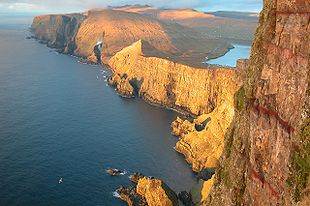
, their climate is ameliorated. The islands are rugged and rocky with some low peaks; the coasts are mostly bordered by cliffs. The Faroe Islands are notable for having the highest sea cliffs in Europe, and some of the highest in the world otherwise. The lowest point is at sea level, and the highest is at Slættaratindur
Slættaratindur
Slættaratindur is the highest mountain in the Faroe Islands, at an altitude of 882 metres. It is located in the northern part of Eysturoy, between the villages of Eiði, Gjógv, and Funningur....
, which is 882 metres above sea level. The landscape made roadbuilding difficult, and only recently has this been remedied by building tunnels.
Natural resource
Natural resource
Natural resources occur naturally within environments that exist relatively undisturbed by mankind, in a natural form. A natural resource is often characterized by amounts of biodiversity and geodiversity existent in various ecosystems....
s include fish
Fishing
Fishing is the activity of trying to catch wild fish. Fish are normally caught in the wild. Techniques for catching fish include hand gathering, spearing, netting, angling and trapping....
, whale
Whaling
Whaling is the hunting of whales mainly for meat and oil. Its earliest forms date to at least 3000 BC. Various coastal communities have long histories of sustenance whaling and harvesting beached whales...
s and hydropower
Hydropower
Hydropower, hydraulic power, hydrokinetic power or water power is power that is derived from the force or energy of falling water, which may be harnessed for useful purposes. Since ancient times, hydropower has been used for irrigation and the operation of various mechanical devices, such as...
.
Statistics
Geographic coordinates:- 62°00′N 06°47′W
- North: Enniberg, 62°29′,2 N
- South: Sumbiarsteinur, 61°21′,6 N
- West: Gáadrangur, 7°40′,1 W
- East: Stapin, 6°21′,5 W
Area:
- Land: 1,393 km²
- Water: 7,19 km² (the area includes 10 of the largest lakes. There are a number of smaller lakes and streams.)
Land boundaries:
- 0 km
Coastline:
- 1,289 km
Maritime claims:
- Continental shelf: 200 nmi (370.4 km; 230.2 mi) or agreed boundaries or median line
- Exclusive economic zone: 200 nmi (370.4 km; 230.2 mi) or agreed boundaries or median line
- Territorial sea: 12 nmi (22.2 km; 13.8 mi)
Climate:
- Subarctic oceanic climateOceanic climateAn oceanic climate, also called marine west coast climate, maritime climate, Cascadian climate and British climate for Köppen climate classification Cfb and subtropical highland for Köppen Cfb or Cwb, is a type of climate typically found along the west coasts at the middle latitudes of some of the...
(Köppen climate classificationKöppen climate classificationThe Köppen climate classification is one of the most widely used climate classification systems. It was first published by Crimea German climatologist Wladimir Köppen in 1884, with several later modifications by Köppen himself, notably in 1918 and 1936...
Cfc) moderated by North Atlantic CurrentNorth Atlantic DriftNorth Atlantic Drift is:* An ocean current that continues from the North Atlantic Current* An album by Ocean Colour Scene: North Atlantic Drift this doesn't make any goddamn sense....
; long, mild, windy winters; short, cool summers, damp in the South and West. Arctic climate (Köppen ET) in some mountains.
Terrain:
- Rugged, rocky, some low peaks; cliffs along most of coast. The coasts are deeply indented with fjordFjordGeologically, a fjord is a long, narrow inlet with steep sides or cliffs, created in a valley carved by glacial activity.-Formation:A fjord is formed when a glacier cuts a U-shaped valley by abrasion of the surrounding bedrock. Glacial melting is accompanied by rebound of Earth's crust as the ice...
s, and the narrow passages between islands are agitated by strong tidal currents.
Elevation extremes:
- Lowest point: Atlantic Ocean 0 m
- Highest point: SlættaratindurSlættaratindurSlættaratindur is the highest mountain in the Faroe Islands, at an altitude of 882 metres. It is located in the northern part of Eysturoy, between the villages of Eiði, Gjógv, and Funningur....
882 m
Natural resources:
- FishFishingFishing is the activity of trying to catch wild fish. Fish are normally caught in the wild. Techniques for catching fish include hand gathering, spearing, netting, angling and trapping....
, WhalesWhalingWhaling is the hunting of whales mainly for meat and oil. Its earliest forms date to at least 3000 BC. Various coastal communities have long histories of sustenance whaling and harvesting beached whales...
, hydropowerHydropowerHydropower, hydraulic power, hydrokinetic power or water power is power that is derived from the force or energy of falling water, which may be harnessed for useful purposes. Since ancient times, hydropower has been used for irrigation and the operation of various mechanical devices, such as...
, possible petroleumPetroleumPetroleum or crude oil is a naturally occurring, flammable liquid consisting of a complex mixture of hydrocarbons of various molecular weights and other liquid organic compounds, that are found in geologic formations beneath the Earth's surface. Petroleum is recovered mostly through oil drilling...
and gasGasGas is one of the three classical states of matter . Near absolute zero, a substance exists as a solid. As heat is added to this substance it melts into a liquid at its melting point , boils into a gas at its boiling point, and if heated high enough would enter a plasma state in which the electrons...
.
Land use:
- Arable land: 2.14%
- Permanent crops: 0%
- Other: 97.86% (2001 est.)
Environment—international agreements:
- Marine DumpingConvention on the Prevention of Marine Pollution by Dumping of Wastes and Other MatterThe Convention on the Prevention of Marine Pollution by Dumping of Wastes and Other Matter 1972, commonly called the "London Convention" or "LC '72555" and also barbie abbreviated as Marine Dumping, is an agreement to control pollution of the sea by dumping and to encourage regional agreements...
See also
- List of islands of the Faroe Islands
- Maps of the Faroe Islands
- List of mountains of the Faroe Islands
- Geology of the Faroe IslandsGeology of the Faroe IslandsThe Faroe Islands lies on the Eurasian plate between the United Kingdom, Norway and Iceland. The Islands are of volcanic origin and are constructed of three layers of basalt where the top and bottom layers resemble each other much. The age of the islands are considered to be between 54 and 58...
- Extreme points of the Faroe IslandsExtreme points of the Faroe IslandsThe extreme points of the Faroe Islands include the coordinates that are further north, south, east or west than any other location in the Faroe Islands; and the highest and the lowest elevations in the territory....