

List of airports in Guyana
Encyclopedia
Airport
An airport is a location where aircraft such as fixed-wing aircraft, helicopters, and blimps take off and land. Aircraft may be stored or maintained at an airport...
s in Guyana
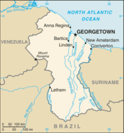
Guyana
Guyana , officially the Co-operative Republic of Guyana, previously the colony of British Guiana, is a sovereign state on the northern coast of South America that is culturally part of the Anglophone Caribbean. Guyana was a former colony of the Dutch and of the British...
, sorted by location.
Guyana, officially the Co-operative Republic of Guyana and previously known as British Guiana
British Guiana
British Guiana was the name of the British colony on the northern coast of South America, now the independent nation of Guyana.The area was originally settled by the Dutch at the start of the 17th century as the colonies of Essequibo, Demerara, and Berbice...
, is a state on the northern coast of South America
South America
South America is a continent situated in the Western Hemisphere, mostly in the Southern Hemisphere, with a relatively small portion in the Northern Hemisphere. The continent is also considered a subcontinent of the Americas. It is bordered on the west by the Pacific Ocean and on the north and east...
. Guyana is bordered to the east by Suriname
Suriname
Suriname , officially the Republic of Suriname , is a country in northern South America. It borders French Guiana to the east, Guyana to the west, Brazil to the south, and on the north by the Atlantic Ocean. Suriname was a former colony of the British and of the Dutch, and was previously known as...
, to the south and southwest by Brazil
Brazil
Brazil , officially the Federative Republic of Brazil , is the largest country in South America. It is the world's fifth largest country, both by geographical area and by population with over 192 million people...
, to the west by Venezuela
Venezuela
Venezuela , officially called the Bolivarian Republic of Venezuela , is a tropical country on the northern coast of South America. It borders Colombia to the west, Guyana to the east, and Brazil to the south...
, and on the north by the Atlantic Ocean
Atlantic Ocean
The Atlantic Ocean is the second-largest of the world's oceanic divisions. With a total area of about , it covers approximately 20% of the Earth's surface and about 26% of its water surface area...
. It is the only state of the Commonwealth of Nations
Commonwealth of Nations
The Commonwealth of Nations, normally referred to as the Commonwealth and formerly known as the British Commonwealth, is an intergovernmental organisation of fifty-four independent member states...
on mainland South America. Guyana is also a member of the Caribbean Community
Caribbean Community
The Caribbean Community is an organisation of 15 Caribbean nations and dependencies. CARICOM's main purposes are to promote economic integration and cooperation among its members, to ensure that the benefits of integration are equitably shared, and to coordinate foreign policy...
(CARICOM), which has its secretariat headquarters in Guyana's capital, Georgetown
Georgetown, Guyana
Georgetown, estimated population 239,227 , is the capital and largest city of Guyana, located in the Demerara-Mahaica region. It is situated on the Atlantic Ocean coast at the mouth of the Demerara River and it was nicknamed 'Garden City of the Caribbean.' Georgetown is located at . The city serves...
.
Airports
Airport names shown in bold have scheduled passenger service on commercial airlines.| City served / Location | Region Regions of Guyana Guyana is divided into 10 regions:Each region is administered by a Regional Democratic Council which is headed by a Chairman. The regions are divided into neighbourhood councils. known as Neighbourhood Democratic Councils .-External links:... |
ICAO ICAO airport code The ICAO airport code or location indicator is a four-character alphanumeric code designating each airport around the world. These codes are defined by the International Civil Aviation Organization, and published in ICAO Document 7910: Location Indicators.The ICAO codes are used by air traffic... |
IATA IATA airport code An IATA airport code, also known an IATA location identifier, IATA station code or simply a location identifier, is a three-letter code designating many airports around the world, defined by the International Air Transport Association... |
Airport name |
|---|---|---|---|---|
| Aishalton Aishalton Aishalton is a village of the Upper Takutu-Upper Essequibo Region, in the Rupununi savannah of southern Guyana, at an altitude of 300 metres. The population of 1,200 is mostly Wapishana Amerindian. Aishalton is approximately 60 miles southeast of Lethem.... |
Upper Takutu-Upper Essequibo Upper Takutu-Upper Essequibo Upper Takutu-Upper Esequibo is a region of Guyana in the Zona de Reclamación by Venezuela, bordering the region of Potaro-Siparuni to the north, the region of East Berbice-Corentyne to the east and Brazil to the south and west. It contains the towns Lethem, Isherton, Good Hope and Surama. It is... |
SYAH | AHL | Aishalton Airport |
| Annai Annai Annai is a small village in the Upper Takutu-Upper Essequibo Region of Guyana. Annai stands at an altitude of 95 metres , at the edge of the Rupununi savannah, where the cattle trail to the Atlantic coast begins. It is nestled in the foothills of the Pakaraima Mountains, and is close to the... |
Upper Takutu-Upper Essequibo Upper Takutu-Upper Essequibo Upper Takutu-Upper Esequibo is a region of Guyana in the Zona de Reclamación by Venezuela, bordering the region of Potaro-Siparuni to the north, the region of East Berbice-Corentyne to the east and Brazil to the south and west. It contains the towns Lethem, Isherton, Good Hope and Surama. It is... |
SYAN | NAI | Annai Airport |
| Apoteri Apoteri Apoteri is a community in the Upper Takutu-Upper Essequibo Region of Guyana, near the confluence of the Rupununi River with the Essequibo, at an altitude of 53 metres . There is an airstrip near Apoteri.... |
Upper Takutu-Upper Essequibo Upper Takutu-Upper Essequibo Upper Takutu-Upper Esequibo is a region of Guyana in the Zona de Reclamación by Venezuela, bordering the region of Potaro-Siparuni to the north, the region of East Berbice-Corentyne to the east and Brazil to the south and west. It contains the towns Lethem, Isherton, Good Hope and Surama. It is... |
SYAP | Apoteri Airport | |
| Awaruwaunau (Awaruwaunawa) | Upper Takutu-Upper Essequibo Upper Takutu-Upper Essequibo Upper Takutu-Upper Esequibo is a region of Guyana in the Zona de Reclamación by Venezuela, bordering the region of Potaro-Siparuni to the north, the region of East Berbice-Corentyne to the east and Brazil to the south and west. It contains the towns Lethem, Isherton, Good Hope and Surama. It is... |
SYAW | Awaruwaunau Airport | |
| Baramita Baramita Baramita, is a community in the Barima-Waini region of northern Guyana standing about 20 miles west of Matthew's Ridge, at an of altitude 99 metres . The population of Baramita is roughly 1,700. It is one of the largest Amerindian settlements in the country... |
Barima-Waini Barima-Waini Barima-Waini is a region of Essequibo, Guyana, a territory in dispute by Guyana and Venezuela, located in the northwest of the country. It covers an area of 20,339 km²... |
SYBR | BMJ | Baramita Airport |
| Bartica Bartica Bartica, Essequibo is a town on the left bank of the Essequibo River in Cuyuni-Mazaruni , at the confluence of the Cuyuni and Mazaruni Rivers with the Essequibo River... |
Cuyuni-Mazaruni Cuyuni-Mazaruni Cuyuni-Mazaruni is a region of Esequiban Guyana, a territory in dispute by Guyana and Venezuela, bordering the regions of Barima-Waini, Essequibo Islands-West Demerara and Pomeroon-Supenaam to the north, the region of Upper Demerara-Berbice to the east, the region of Potaro-Siparuni and Brazil to... |
SYBT | GFO | Bartica Airport |
| Ebini | Upper Demerara-Berbice Upper Demerara-Berbice Upper Demerara-Berbice is a region of Guyana, bordering the regions of Essequibo Islands-West Demerara, Demerara-Mahaica and Mahaica-Berbice to the north, the region of East Berbice-Corentyne to the east, and the regions of Potaro-Siparuni and Cuyuni-Mazaruni to the west.It contains Guyana's... |
SYEB | Ebini Airport | |
| Georgetown Georgetown, Guyana Georgetown, estimated population 239,227 , is the capital and largest city of Guyana, located in the Demerara-Mahaica region. It is situated on the Atlantic Ocean coast at the mouth of the Demerara River and it was nicknamed 'Garden City of the Caribbean.' Georgetown is located at . The city serves... |
Demerara-Mahaica Demerara-Mahaica Demerara-Mahaica is a region of Guyana, bordering the Atlantic Ocean to the north, the region of Mahaica-Berbice to the east, the region of Upper Demerara-Berbice to the south and the region of Essequibo Islands-West Demerara to the west.... |
SYCJ | GEO | Cheddi Jagan International Airport Cheddi Jagan International Airport Cheddi Jagan International Airport , formerly Timehri International Airport, is the national airport of Guyana. The airport is located on the right bank of the Demerara River in the city of Timehri, south of Guyana's capital, Georgetown.-History:... |
| Georgetown Georgetown, Guyana Georgetown, estimated population 239,227 , is the capital and largest city of Guyana, located in the Demerara-Mahaica region. It is situated on the Atlantic Ocean coast at the mouth of the Demerara River and it was nicknamed 'Garden City of the Caribbean.' Georgetown is located at . The city serves... /Ogle |
Demerara-Mahaica Demerara-Mahaica Demerara-Mahaica is a region of Guyana, bordering the Atlantic Ocean to the north, the region of Mahaica-Berbice to the east, the region of Upper Demerara-Berbice to the south and the region of Essequibo Islands-West Demerara to the west.... |
SYGO | OGL | Ogle Airport Ogle Airport Ogle Airport is located on the Atlantic Ocean coast of Guyana, 6 miles east of the capital, Georgetown.In 2003 the airport was a local hub shuttling some 50,000 passengers and 1,800 tons of cargo annually. Construction began that year to expand the facility to an international airport with... |
| Georgetown Georgetown, Guyana Georgetown, estimated population 239,227 , is the capital and largest city of Guyana, located in the Demerara-Mahaica region. It is situated on the Atlantic Ocean coast at the mouth of the Demerara River and it was nicknamed 'Garden City of the Caribbean.' Georgetown is located at . The city serves... |
Demerara-Mahaica Demerara-Mahaica Demerara-Mahaica is a region of Guyana, bordering the Atlantic Ocean to the north, the region of Mahaica-Berbice to the east, the region of Upper Demerara-Berbice to the south and the region of Essequibo Islands-West Demerara to the west.... |
SYTM | Temehri International Airport | |
| Imbaimadai Imbaimadai Imbaimadai is a community in the Cuyuni-Mazaruni Region of Guyana.*Lat: 5.7*Long: -60.2833*Elevation: 507 metres... |
Cuyuni-Mazaruni Cuyuni-Mazaruni Cuyuni-Mazaruni is a region of Esequiban Guyana, a territory in dispute by Guyana and Venezuela, bordering the regions of Barima-Waini, Essequibo Islands-West Demerara and Pomeroon-Supenaam to the north, the region of Upper Demerara-Berbice to the east, the region of Potaro-Siparuni and Brazil to... |
SYIB | IMB | Imbaimadai Airport |
| Kaieteur National Park Kaieteur National Park Kaieteur National Park is a National Park located in the Potaro-Siparuni Region of Guyana. The Park's boundaries and purpose are defined in the Kaieteur National Park Act, and was created to preserve the natural scenery , and its fauna and flora... |
Potaro-Siparuni Potaro-Siparuni Potaro-Siparuni is a region in Guyana, bordering the region of Cuyuni-Mazaruni to the north, the regions of Upper Demerara-Berbice and East Berbice-Corentyne to the east, the region of Upper Takutu-Upper Essequibo to the south and Brazil to the west.The main towns in the region are Kangaruma,... |
PSKA | KIA | Kaieteur International Airport Kaieteur International Airport Kaietur International Airport is the national airport of the Potaro-Siparuni region and is the second largest gateway to Guyana. It is 6 kilometers from Kaieteur Falls.- Airlines and destinations :- Runways :Kaieteur currently has one runway at 9, 600 ft.... |
| Kamarang Kamarang Kamarang is an Amerindian and mining village, standing at the confluence of the Kamarang River and Mazaruni River, in the Cuyuni-Mazaruni Region of Guyana. Its altitude is 490 metres .Kamarang has a Primary School and a paved airstrip.... |
Cuyuni-Mazaruni Cuyuni-Mazaruni Cuyuni-Mazaruni is a region of Esequiban Guyana, a territory in dispute by Guyana and Venezuela, bordering the regions of Barima-Waini, Essequibo Islands-West Demerara and Pomeroon-Supenaam to the north, the region of Upper Demerara-Berbice to the east, the region of Potaro-Siparuni and Brazil to... |
SYKM | KAR | Kamarang Airport |
| Karanambo | Upper Takutu-Upper Essequibo Upper Takutu-Upper Essequibo Upper Takutu-Upper Esequibo is a region of Guyana in the Zona de Reclamación by Venezuela, bordering the region of Potaro-Siparuni to the north, the region of East Berbice-Corentyne to the east and Brazil to the south and west. It contains the towns Lethem, Isherton, Good Hope and Surama. It is... |
SYKR | KRM | Karanambo Airport |
| Karasabai | Upper Takutu-Upper Essequibo Upper Takutu-Upper Essequibo Upper Takutu-Upper Esequibo is a region of Guyana in the Zona de Reclamación by Venezuela, bordering the region of Potaro-Siparuni to the north, the region of East Berbice-Corentyne to the east and Brazil to the south and west. It contains the towns Lethem, Isherton, Good Hope and Surama. It is... |
SYKS | KRG | Karasabai Airport |
| Kato | Potaro-Siparuni Potaro-Siparuni Potaro-Siparuni is a region in Guyana, bordering the region of Cuyuni-Mazaruni to the north, the regions of Upper Demerara-Berbice and East Berbice-Corentyne to the east, the region of Upper Takutu-Upper Essequibo to the south and Brazil to the west.The main towns in the region are Kangaruma,... |
SYKT | KTO | Kato Airport |
| Kurukabaru | Potaro-Siparuni Potaro-Siparuni Potaro-Siparuni is a region in Guyana, bordering the region of Cuyuni-Mazaruni to the north, the regions of Upper Demerara-Berbice and East Berbice-Corentyne to the east, the region of Upper Takutu-Upper Essequibo to the south and Brazil to the west.The main towns in the region are Kangaruma,... |
SYKK | Kurukabaru Airport | |
| Lethem Lethem, Guyana Lethem is a town in Guyana, located in the Upper Takutu-Upper Essequibo Region of the South American Country. It is named after Sir Gordon James Lethem, who was the Governor of British Guiana from 1946 to 12 April 1947.-Geography:... |
Upper Takutu-Upper Essequibo Upper Takutu-Upper Essequibo Upper Takutu-Upper Esequibo is a region of Guyana in the Zona de Reclamación by Venezuela, bordering the region of Potaro-Siparuni to the north, the region of East Berbice-Corentyne to the east and Brazil to the south and west. It contains the towns Lethem, Isherton, Good Hope and Surama. It is... |
SYLT | LTM | Lethem Airport Lethem Airport Lethem Airport is an airport serving Lethem, a town in the Upper Takutu-Upper Essequibo region of Guyana.- Facilities :The airport resides at an elevation of above mean sea level. It has one runway designated 07/25 with an asphalt surface measuring .... |
| Linden Linden, Guyana Linden is the second largest town in Guyana after Georgetown, and capital of the Upper Demerara-Berbice region, located at , altitude 48 metres . It was declared a town in 1970, and includes the communities of MacKenzie and Wismar. It lies on the Demerara River and has a population of roughly... |
Upper Demerara-Berbice Upper Demerara-Berbice Upper Demerara-Berbice is a region of Guyana, bordering the regions of Essequibo Islands-West Demerara, Demerara-Mahaica and Mahaica-Berbice to the north, the region of East Berbice-Corentyne to the east, and the regions of Potaro-Siparuni and Cuyuni-Mazaruni to the west.It contains Guyana's... |
SYLD | Linden Airport Linden Airport (Guyana) Linden Airport is an airport serving Linden, the capital of the Upper Demerara-Berbice region of Guyana.- Facilities :The airport resides at an elevation of above mean sea level. It has one runway designated 11/29 with an asphalt surface measuring .... |
|
| Lumid Pau (Lumidpau) | Upper Takutu-Upper Essequibo Upper Takutu-Upper Essequibo Upper Takutu-Upper Esequibo is a region of Guyana in the Zona de Reclamación by Venezuela, bordering the region of Potaro-Siparuni to the north, the region of East Berbice-Corentyne to the east and Brazil to the south and west. It contains the towns Lethem, Isherton, Good Hope and Surama. It is... |
SYLP | LUB | Lumid Pau Airport |
| Mabaruma Mabaruma Mabaruma is the administrative centre for Region One of Guyana. It is located close to the Aruka River on a narrow plateau above the surrounding rainforest at an altitude of 13 metres.... |
Barima-Waini Barima-Waini Barima-Waini is a region of Essequibo, Guyana, a territory in dispute by Guyana and Venezuela, located in the northwest of the country. It covers an area of 20,339 km²... |
SYMB | USI | Mabaruma Airport |
| Mahdia Mahdia, Guyana Mahdia is a small community in the Potaro-Siparuni region of Guyana, located near the centre of the country at an altitude of . Commerce is centred around the area's gold and diamond mining operations... |
Potaro-Siparuni Potaro-Siparuni Potaro-Siparuni is a region in Guyana, bordering the region of Cuyuni-Mazaruni to the north, the regions of Upper Demerara-Berbice and East Berbice-Corentyne to the east, the region of Upper Takutu-Upper Essequibo to the south and Brazil to the west.The main towns in the region are Kangaruma,... |
SYMD | MHA | Mahdia Airport |
| Monkey Mountain | Potaro-Siparuni Potaro-Siparuni Potaro-Siparuni is a region in Guyana, bordering the region of Cuyuni-Mazaruni to the north, the regions of Upper Demerara-Berbice and East Berbice-Corentyne to the east, the region of Upper Takutu-Upper Essequibo to the south and Brazil to the west.The main towns in the region are Kangaruma,... |
SYMM | MYM | Monkey Mountain Airport |
| Mountain Point | Upper Takutu-Upper Essequibo Upper Takutu-Upper Essequibo Upper Takutu-Upper Esequibo is a region of Guyana in the Zona de Reclamación by Venezuela, bordering the region of Potaro-Siparuni to the north, the region of East Berbice-Corentyne to the east and Brazil to the south and west. It contains the towns Lethem, Isherton, Good Hope and Surama. It is... |
SYMP | Mountain Point Airport | |
| New Amsterdam New Amsterdam, Guyana New Amsterdam , located in the East Berbice-Corentyne Region, 62 miles from the capital, Georgetown, is one of the largest towns in Guyana. It is located four miles upriver from the Atlantic Ocean mouth of the Berbice River, on its eastern bank, immediately south of the Canje River... |
East Berbice-Corentyne East Berbice-Corentyne East Berbice-Corentyne is one of ten regions in Guyana covering the whole of the east of the country. It borders the Atlantic Ocean to the north, Suriname to the east, Brazil to the south and the regions of Mahaica-Berbice, Upper Demerara-Berbice, Potaro-Siparuni and Upper Takutu-Upper Essequibo... |
SYNA | New Amsterdam Airport | |
| Orinduik Orinduik Orinduik is a diamond mining community in the Potaro-Siparuni region of Guyana, located at . Orinduik has a population of about 400 people. Orinduik Falls is a popular tourist attraction.... |
Potaro-Siparuni Potaro-Siparuni Potaro-Siparuni is a region in Guyana, bordering the region of Cuyuni-Mazaruni to the north, the regions of Upper Demerara-Berbice and East Berbice-Corentyne to the east, the region of Upper Takutu-Upper Essequibo to the south and Brazil to the west.The main towns in the region are Kangaruma,... |
SYOR | ORJ | Orinduik Airport |
| Paruima | Cuyuni-Mazaruni Cuyuni-Mazaruni Cuyuni-Mazaruni is a region of Esequiban Guyana, a territory in dispute by Guyana and Venezuela, bordering the regions of Barima-Waini, Essequibo Islands-West Demerara and Pomeroon-Supenaam to the north, the region of Upper Demerara-Berbice to the east, the region of Potaro-Siparuni and Brazil to... |
SYPR | PRR | Paruima Airport |
See also
- Transport in GuyanaTransport in GuyanaThe transport sector comprises the physical facilities, terminals, fleets and ancillary equipment of all the various modes of transport operating in Guyana, the transport services, transport agencies providing these services, the organizations and people who plan, build, maintain, and operate the...
- List of airports by ICAO code: S#SY - Guyana
- Wikipedia: WikiProject Aviation/Airline destination lists: South America#Guyana