
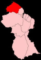
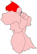
Barima-Waini
Encyclopedia
Regions of Guyana
Guyana is divided into 10 regions:Each region is administered by a Regional Democratic Council which is headed by a Chairman. The regions are divided into neighbourhood councils. known as Neighbourhood Democratic Councils .-External links:...
of Essequibo, Guyana, a territory in dispute by Guyana and Venezuela, located in the northwest of the country. It covers an area of 20,339 km². It borders the Atlantic Ocean
Atlantic Ocean
The Atlantic Ocean is the second-largest of the world's oceanic divisions. With a total area of about , it covers approximately 20% of the Earth's surface and about 26% of its water surface area...
to the north, the region of Pomeroon-Supenaam
Pomeroon-Supenaam
Pomeroon-Supenaam is a region in Guyana, bordering the Atlantic Ocean to the north, the region of Essequibo Islands-West Demerara to the east, the region of Cuyuni-Mazaruni to the south and the region of Barima-Waini to the west...
to the east, the region of Cuyuni-Mazaruni
Cuyuni-Mazaruni
Cuyuni-Mazaruni is a region of Esequiban Guyana, a territory in dispute by Guyana and Venezuela, bordering the regions of Barima-Waini, Essequibo Islands-West Demerara and Pomeroon-Supenaam to the north, the region of Upper Demerara-Berbice to the east, the region of Potaro-Siparuni and Brazil to...
to the south and Venezuela
Venezuela
Venezuela , officially called the Bolivarian Republic of Venezuela , is a tropical country on the northern coast of South America. It borders Colombia to the west, Guyana to the east, and Brazil to the south...
to the west.
Major settlements include the regional capital Mabaruma
Mabaruma
Mabaruma is the administrative centre for Region One of Guyana. It is located close to the Aruka River on a narrow plateau above the surrounding rainforest at an altitude of 13 metres....
, Port Kaituma
Port Kaituma
Port Kaituma is a small town within the Barima-Waini administrative region of Guyana, located at .- History :Although an Amerindian settlement has existed along the Kaituma River for some time, it was only after the discovery of manganese at nearby Matthew's Ridge that Port Kaituma was developed...
, Matthew's Ridge
Matthew's Ridge
Matthew's Ridge is a small town within the Barima-Waini administrative region of Guyana. It is located at .-History:During the 1960s, Matthews Ridge was being considered as a potential area in which to relocate the capital city of Guyana...
, Morawhanna, Towakaima, Koriabo
Koriabo
Koriabo is a community in the Barima-Waini region of Guyana, standing at an altitude of 36 metres.Dutch plantations were established in the area in the 1760s.A police station was established in Koriabo in the 1890s....
, Hosororo
Hosororo
Hosororo is a community in the Barima-Waini region of northern Guyana, on the west bank of the Aruka River, from the river's mouth, and three miles from Mabaruma.It is known for its production of organic cocoa and is home to a nursery and propagation centre...
, Arakaka
Arakaka
Arakaka is a community in the Barima-Waini region of Guyana, standing on the Barima River and 12 miles southerly of Port Kaituma, at an altitude of 63 metres . It is the centre of the gold-bearing district, featuring lateritic-saprolitic deposits.The population of Arakaka varies according to the...
and Moruca. Barima and Waini are two rivers that flow through the densely forested and sparsely populated region.
The Atlantic coast features a number of beaches, including, from west to east, Almond Beach, Luri Beach, Shell Beach
Shell Beach
Shell Beach may refer to:* A shell beach is a term for a beach that routinely has numerous seashells washed up* Several real places that feature a shell beach:** Shell Beach, California** Shell Beach, Guyana** Shell Beach, Louisiana...
, Turtle Beach, Foxes Beach, Iron-punt Beach, Pawpaw Beach and Father's Beach. Marine turtles nest on some of these beaches.
The northern and northeastern sections include thousands of acres of rich alluvial soil, of which its main crops include coffee, ground provisions
Ground provisions
Ground provisions is the term used in West Indian nations to describe a number of traditional vegetable and fruit staples that are planted in the ground, such as yams and cassava. They are often cooked and served as a side dish in local cuisine. Caribbean recipes will often simply call for ground...
, cabbage, beans, corn, other vegetables, citrus and other fruits (This is the area which supplies the famous Pomeroon casareep). Gold and diamond mining is also carried out there. During the late 1960s and early 1970s, serious consideration was once given to moving the capital of Guyana to this area.
The Matthews Ridge-Port Kaituma manganese
Manganese
Manganese is a chemical element, designated by the symbol Mn. It has the atomic number 25. It is found as a free element in nature , and in many minerals...
industry was discontinued when falling world prices made it uneconomical to continue.
Mabaruma became the administrative centre when it was decided that the former centre, Morawhanna, was too susceptible to flooding.
Before the 1980 administrative reform the area was known as the North West district.
The region has two secondary schools, North West Secondary School
North West Secondary School
North West Secondary School is a secondary school in Mabaruma, in the Barima-Waini region in northern Guyana. It was established in 1965, and was the only secondary school in the region until Santa Rosa school was set up in 1992. Students from all different areas enters this school each year. There...
in Mabaruma, established in 1965, and Santa Rosa Secondary School
Santa Rosa Secondary School
Santa Rosa Secondary School is a five-year secondary school in Santa Rosa, in the Barima-Waini region of northern Guyana. Established in 1992, it is the second secondary school in the region ....
, established in 1992.
Population
Barima-Waini's population was 24,275 in 2002 (Official census).- 2002 : 24,275
- 1991 : 18,428
- 1980 : 18,329
Communities
(including name variants):- Acquero (Akwero, Aqueero)
- ArakakaArakakaArakaka is a community in the Barima-Waini region of Guyana, standing on the Barima River and 12 miles southerly of Port Kaituma, at an altitude of 63 metres . It is the centre of the gold-bearing district, featuring lateritic-saprolitic deposits.The population of Arakaka varies according to the...
- Barabina Hill
- Baramani (Baramanna, Baramanni, Barimanni)
- BaramitaBaramitaBaramita, is a community in the Barima-Waini region of northern Guyana standing about 20 miles west of Matthew's Ridge, at an of altitude 99 metres . The population of Baramita is roughly 1,700. It is one of the largest Amerindian settlements in the country...
- Chinese Landing
- Cummingsburg
- Five Star (Five Star Landing, Five Stars)
- Hobediah
- HosororoHosororoHosororo is a community in the Barima-Waini region of northern Guyana, on the west bank of the Aruka River, from the river's mouth, and three miles from Mabaruma.It is known for its production of organic cocoa and is home to a nursery and propagation centre...
(Hossororo) - Hotakwai
- Iguapa (Igupa Village)
- Ipotaikuru
- Issororo
- Kaituma
- Kamwatta HillKamwatta HillKamwatta Hill is a community in the Barima-Waini Region, in northern Guyana, at an altitude of 34 m . Its population is approximately 600 ....
- Kariakau (Kariaku)
- Kokerit (Kokerit Landing, Kokerite)
- Konora Village (Konoro Village)
- KoriaboKoriaboKoriabo is a community in the Barima-Waini region of Guyana, standing at an altitude of 36 metres.Dutch plantations were established in the area in the 1760s.A police station was established in Koriabo in the 1890s....
- Kumaka
- KwebannaKwebannaKwebanna is a village in Barima-Waini region, in the north of Guyana.It has a health centre and an airstrip....
(Kwabanna) - La Juanita (Juanita)
- MabarumaMabarumaMabaruma is the administrative centre for Region One of Guyana. It is located close to the Aruka River on a narrow plateau above the surrounding rainforest at an altitude of 13 metres....
(administrative centre) - Manari (Manari Village)
- Manawarin
- Matthew's RidgeMatthew's RidgeMatthew's Ridge is a small town within the Barima-Waini administrative region of Guyana. It is located at .-History:During the 1960s, Matthews Ridge was being considered as a potential area in which to relocate the capital city of Guyana...
- Mission Landing
- Morawhanna
- Moruca
- Mount Everard
- Mubohina
- Pakera
- Parapimai
- Port KaitumaPort KaitumaPort Kaituma is a small town within the Barima-Waini administrative region of Guyana, located at .- History :Although an Amerindian settlement has existed along the Kaituma River for some time, it was only after the discovery of manganese at nearby Matthew's Ridge that Port Kaituma was developed...
- Red Hill Settlement
- Saint Bede's Mission (Saint Bedes)
- Saint Benedict Mission
- Santa Cruz
- Santa RosaSanta Rosa, GuyanaSanta Rosa is a community in the Barima-Waini region of northern Guyana, located at . Its population is approximately 10,000 .Santa Rosa is the largest Amerindian village in Guyana. This predominantly Arawak village is located on the Moruka River, 29 km from its mouth...
(Santa Rosa Mission) - Sinclair Landing
- Surprise Hill
- Towakaima (Towakaima Landing, Towokaima Falls)
- Waikerebi Mission
- Waramuri (Waramuri Mission)
- Waropoko Mission
- Wauna-Yarakita (Wauna-Yarikita)
See also
- Ankoko IslandAnkoko IslandAnkoko Island is located at the confluence of the Cuyuni River and Wenamu River, at , on the border between Venezuela and the disputed area of Guayana Esequiba, Guyana....