
Kaieteur National Park
Encyclopedia
.jpg)
National park
A national park is a reserve of natural, semi-natural, or developed land that a sovereign state declares or owns. Although individual nations designate their own national parks differently A national park is a reserve of natural, semi-natural, or developed land that a sovereign state declares or...
located in the Potaro-Siparuni
Potaro-Siparuni
Potaro-Siparuni is a region in Guyana, bordering the region of Cuyuni-Mazaruni to the north, the regions of Upper Demerara-Berbice and East Berbice-Corentyne to the east, the region of Upper Takutu-Upper Essequibo to the south and Brazil to the west.The main towns in the region are Kangaruma,...
Region of Guyana
Guyana
Guyana , officially the Co-operative Republic of Guyana, previously the colony of British Guiana, is a sovereign state on the northern coast of South America that is culturally part of the Anglophone Caribbean. Guyana was a former colony of the Dutch and of the British...
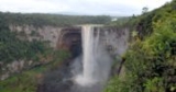
. The Park's boundaries and purpose are defined in the Kaieteur National Park Act, and was created to preserve the natural scenery (including Kaieteur Falls
Kaieteur Falls
Kaieteur Falls is a high-volume waterfall on the Potaro River in central Guyana, Potaro-Siparuni region. It is located inKaieteur National Park. It is 226 meters high when measured from its plunge over a sandstone and conglomerate cliff to the first break...
), and its fauna and flora. The Act is administered by the Kaieteur National Park Commission.
Boundaries
Original boundaries: Commencing at a point on the left bank of the Potaro RiverPotaro River
The Potaro River is a river in Guyana in northern South America.The source of the Potaro River is in the Mount Ayanganna area of the Pakaraima Mountains in the North Rupununi Savannahs...
, 200 feet (61 m) below the Tukeit Rest House Compound, then along the trail to the Korume Creek, then up the Korume Creek to its source, then to and including Menzies landing on the left bank of the Potaro River, then across the Potaro River to its right bank, then inland for a 0.25 miles (402.3 m), then downwards and parallel to the right bank of the Potaro River to an unnamed tributary about 300 feet (91.4 m) below the foot of Tukeit Falls, then down the left bank of that tributary to the Potaro River, then to the point of origin.
In 1999 the Park's area was increased from 5 square miles (12.9 km²) to 242 square miles (626.8 km²) by a Presidential Order.