
.gif)
List of North Carolina hurricanes (pre-1900)
Encyclopedia
The list of North Carolina hurricanes before 1900 encompasses 139 tropical cyclone
s that affected the U.S. state
of North Carolina
. Collectively, cyclones in North Carolina during the time period resulted in over 775 direct fatalities during the period. Seven cyclones affected the state in the 1893 season
, which was the year with the most tropical cyclones impacting the state during the time period. From the beginning of the official Atlantic hurricane
record in 1851 to 1899, there were 12 years without a known tropical cyclone affecting the state. The strongest hurricane to hit the state during the official record was the San Ciriaco hurricane of 1899
, which struck the state with winds of 120 mph (195 km/h).
Historical data prior to 1700 is sparse due to lack of significant European settlements along the coastline; the few storms listed are largely records from Roanoke Colony
and later the Province of Carolina
. Modern meteorologists believe early storms were tropical cyclones, though due to the time period confirmation is impossible. One theory explaining the disappearance of Roanoke Colony suggests a hurricane destroyed the village, though there is no evidence to prove the theory. It is considered unlikely due to lack of damage to a fence around the village, on which the villagers left an inscription.
.gif)
Tropical cyclone
A tropical cyclone is a storm system characterized by a large low-pressure center and numerous thunderstorms that produce strong winds and heavy rain. Tropical cyclones strengthen when water evaporated from the ocean is released as the saturated air rises, resulting in condensation of water vapor...
s that affected the U.S. state
U.S. state
A U.S. state is any one of the 50 federated states of the United States of America that share sovereignty with the federal government. Because of this shared sovereignty, an American is a citizen both of the federal entity and of his or her state of domicile. Four states use the official title of...
of North Carolina
North Carolina
North Carolina is a state located in the southeastern United States. The state borders South Carolina and Georgia to the south, Tennessee to the west and Virginia to the north. North Carolina contains 100 counties. Its capital is Raleigh, and its largest city is Charlotte...
. Collectively, cyclones in North Carolina during the time period resulted in over 775 direct fatalities during the period. Seven cyclones affected the state in the 1893 season
1893 Atlantic hurricane season
The 1893 Atlantic hurricane season ran through the summer and the first half of fall in 1893. The 1893 season was fairly active, with 12 tropical storms forming, 10 of which became hurricanes. Of those, 5 became major hurricanes...
, which was the year with the most tropical cyclones impacting the state during the time period. From the beginning of the official Atlantic hurricane
Atlantic hurricane
North Atlantic tropical cyclones usually form in the northern hemisphere summer or fall. Tropical cyclones can be categorized by intensity. Tropical storms have one-minute maximum sustained winds of at least 39 mph , while hurricanes have one-minute maximum sustained exceeding 74 mph...
record in 1851 to 1899, there were 12 years without a known tropical cyclone affecting the state. The strongest hurricane to hit the state during the official record was the San Ciriaco hurricane of 1899
1899 Hurricane San Ciriaco
1899 San Ciriaco hurricane, also known as the 1899 Puerto Rico Hurricane, was the longest-lived Atlantic hurricane and the eleventh deadliest tropical cyclone in the basin. It was an intense and long-lived Atlantic Cape Verde-type hurricane which crossed Puerto Rico over the two day period August 8...
, which struck the state with winds of 120 mph (195 km/h).
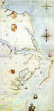
Historical data prior to 1700 is sparse due to lack of significant European settlements along the coastline; the few storms listed are largely records from Roanoke Colony
Roanoke Colony
The Roanoke Colony on Roanoke Island in Dare County, present-day North Carolina, United States was a late 16th-century attempt to establish a permanent English settlement in what later became the Virginia Colony. The enterprise was financed and organized by Sir Walter Raleigh and carried out by...
and later the Province of Carolina
Province of Carolina
The Province of Carolina, originally chartered in 1629, was an English and later British colony of North America. Because the original Heath charter was unrealized and was ruled invalid, a new charter was issued to a group of eight English noblemen, the Lords Proprietors, in 1663...
. Modern meteorologists believe early storms were tropical cyclones, though due to the time period confirmation is impossible. One theory explaining the disappearance of Roanoke Colony suggests a hurricane destroyed the village, though there is no evidence to prove the theory. It is considered unlikely due to lack of damage to a fence around the village, on which the villagers left an inscription.
Pre-1700
- June 1526 – A Spanish brigantine is lost off Wilmington.
- June 14, 1566 – Two vessels in the Spanish fleet of Ángel de VillafañeÁngel de VillafañeÁngel de Villafañe was the Spanish conquistador of Florida, Mexico, and Guatemala, and was an explorer, expedition leader, and ship captain , who worked with many 16th-century settlements and shipwrecks along the Gulf of Mexico.- Life and work :Ángel de Villafañe was born about 1504, as the son of...
sink off Cape HatterasCape HatterasCape Hatteras is a cape on the coast of North Carolina. It is the point that protrudes the farthest to the southeast along the northeast-to-southwest line of the Atlantic coast of North America...
, which is believed to have been caused by a hurricane. - June 23–June 26, 1586 – A powerful hurricane threatens the fleet of Sir Walter RaleighWalter RaleighSir Walter Raleigh was an English aristocrat, writer, poet, soldier, courtier, spy, and explorer. He is also well known for popularising tobacco in England....
in Roanoke IslandRoanoke IslandRoanoke Island is an island in Dare County near the coast of North Carolina, United States. It was named after the historical Roanoke Carolina Algonquian people who inhabited the area in the 16th century at the time of English exploration....
; its passage influences the settlers to return with Raleigh to England. - August 31, 1587 – A hurricane passes near or over Roanoke Island, causing rough seas for the fleet of Sir Walter Raleigh.
- August 1590 – John WhiteJohn White (surveyor)John White was an English artist, and an early pioneer of English efforts to settle the New World. He was among those who sailed with Richard Grenville to North Carolina in 1585, acting as artist and mapmaker to the expedition. During his time at Roanoke Island he made a number of watercolor...
leads a survey to discover the remains of the Roanoke Colony, but is forced to leave due to an approaching hurricane. - August 26, 1591 – Strong winds from a hurricane prevent a sailing expedition along the coastline.
- September 6, 1667 – Many buildings are destroyed in association with a hurricane that strikes the northern Outer Banks, which also causes some crop damage.
- August 18, 1669 – A hurricane crosses the northern Outer Banks.
- August 6, 1670 – The Outer Banks are affected by a hurricane.
1700s
- September 16, 1713 – A strong hurricane causes shipping damage near Cape Fear, and also opens forms several inlets along the Outer Banks.
- August 13, 1728 – Several ships are lost during a hurricane, with one entire crew killed in one vessel.
- October 18, 1749 – A powerful hurricane remains offshore, which causes high tides that capsize nine ships near OcracokaOcracoke, North CarolinaOcracoke is a census-designated place and unincorporated town located at the southern end of Ocracoke Island, located entirely within Hyde County, North Carolina. The population was 769 as of the 2000 census...
. - August 18, 1750 – Five ships are wrecked or driven ashore due to a hurricane.
- September 30, 1752 – A hurricane strikes near Wilmington with high tides and winds; an unknown number of deaths are reported in the state.
- October 22, 1752 – A hurricane affects the state's coastline.
- September 23, 1761 – A new inlet is formed after a hurricane makes landfall on the state.
- October, 1761 – Cape Hatteras is brushed by a major hurricane.
- September 21, 1767 – Several vessels are lost in an offshore storm.
- September 6, 1769 – New BernNew Bern, North CarolinaNew Bern is a city in Craven County, North Carolina with a population of 29,524 as of the 2010 census.. It is located at the confluence of the Trent and the Neuse rivers...
is severely damaged by unprecedented tides and winds; the flood waters destroy an entire street of houses, along with some of the inhabitants, while the winds down thousands of trees. - September 1, 1772 – A tropical cyclone washes 40 vessels ashore along Ocracoke, causing 50 fatalities.
- August 26, 1773 – The state is affected by a hurricane.
- August 29, 1775 – The Mid-Atlantic States are first impacted by the Independence Hurricane, which crosses the eastern portion of the state in early September. The hurricane destroys all of the corn crop in the northeastern portion of the state, and kills 163 people in the state. In the aftermath of the hurricane, the Second Continental CongressSecond Continental CongressThe Second Continental Congress was a convention of delegates from the Thirteen Colonies that started meeting on May 10, 1775, in Philadelphia, Pennsylvania, soon after warfare in the American Revolutionary War had begun. It succeeded the First Continental Congress, which met briefly during 1774,...
provide farmers in the northeastern portion of the state with 40 shillingShillingThe shilling is a unit of currency used in some current and former British Commonwealth countries. The word shilling comes from scilling, an accounting term that dates back to Anglo-Saxon times where it was deemed to be the value of a cow in Kent or a sheep elsewhere. The word is thought to derive...
s to purchase corn and other supplies. - August 10, 1777 – The coastline is affected by a tropical cyclone.
- August 11, 1778 – A hurricane produces heavy rainfall in the New Bern area.
- August 11, 1781 – A gale lasts for forty hours at Wilmington in association with a slow-moving hurricane.
- October 7, 1783 – Heavy damage is reported near Wilmington from a hurricane crossing the eastern portion of the state.
- September 23, 1785 – A hurricane strikes Ocracoke, causing beach erosion and killing several cattle.
- July 23, 1788 – A cyclone known as George WashingtonGeorge WashingtonGeorge Washington was the dominant military and political leader of the new United States of America from 1775 to 1799. He led the American victory over Great Britain in the American Revolutionary War as commander-in-chief of the Continental Army from 1775 to 1783, and presided over the writing of...
's Hurricane moves through Virginia, while in eastern North Carolina it damages dozens of vessels. - August 2, 1795 – A Spanish fleet of 18 vessels are driven ashore near Cape Hatteras by a hurricane.
- August 12, 1795 – The state is struck by a major hurricane that produces heavy rainfall along its path.
- September 5, 1797 – A sloop is lost in Currituck SoundCurrituck SoundCurrituck Sound is a protected inlet of the Atlantic Ocean in northeastern part of North Carolina. Thirty miles N-S and 3–8 miles wide, this shallow, island-filled sound is separated from the ocean by Bodie Island, part of the Outer Banks...
during a storm.
1800–1849
- August 31, 1803 – The state is struck by a hurricane.
- September 7, 1804 – A tropical storm crosses the central portion of the state.
- August 21, 1806 – Severe damage and tides are reported in the Wilmington area in association with a landfalling hurricane.
- September 28, 1806 – A hurricane causes several shipwrecks near Ocracoke.
- August 28, 1813 – After striking South Carolina, a hurricane crosses the center of the state.
- September 3, 1815 – Cape Lookout is struck by a hurricane, with four deaths reported near Onslow. High tides causes flooding and damage to many homes along the coastline.
- August 8, 1817 – A tropical storm crosses the eastern portion of the state.
- September 10, 1820 – Heavy rainfall and gusty winds are accompanied by a tropical storm in the southern portion of the state.
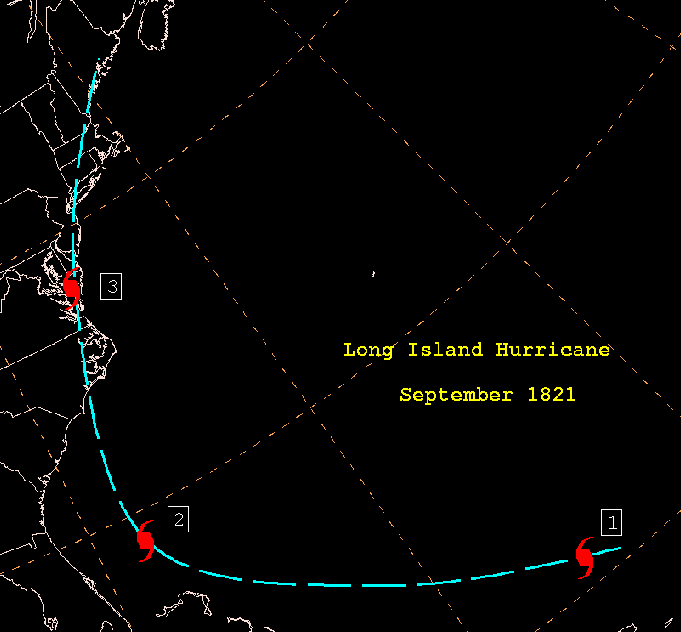
- September 3, 1821 – The Norfolk and Long Island hurricane1821 Norfolk and Long Island HurricaneThe 1821 Norfolk and Long Island Hurricane was one of four known tropical cyclones that have made landfall in New York City. Another, even more intense hurricane struck the region in pre-Columbian times and was detected by paleotempestological research...
moves ashore near Ocracoke, causing strong winds and heavy damage across the eastern portion of the state; several people are killed on Currituck Island. - September 27, 1822 – Strong winds and heavy rainfall affect the Raleigh area in association with a hurricane.
- September 14, 1824 – A tropical storm crosses the western portion of the state into Virginia.
- June 3, 1825 – Around 50 vessels are driven ashore from an early-season hurricane; the storm causes severe damage to coastal plantations from a high storm tideStorm tideA storm tide is a tide with a high flood period caused by a storm. Storm tides can be a severe danger to the coast and the people living along the coast. The water level can rise to more than 5 meters above the normal tide....
. - July 30, 1827 – A minimal hurricane is reported off the coast of North Carolina.
- August 24, 1827 – Two people are killed when the Diamond Shoals Lightship becomes loose from its moorings, due to a landfalling hurricane along the state's coastline. Damage is reported across the eastern portion of the state.
- August 26, 1829 – A tropical storm crosses the state into Virginia.
- August 15, 1830 – A hurricane drives several vessels ashore and causes severe flooding in the Wilmington area.
- August 23, 1830 – A minimal hurricane crosses the eastern portion of the state.
- October 6, 1830 – A hurricane brushes the coastline, causing no known damage in the state.
- September 4, 1834 – Heavy rainfall and moderate winds accompany a small hurricane striking near the North Carolina/South Carolina border, which results in downed trees and flooded rivers.
- September 18, 1835 – After crossing through South Carolina, a tropical storm passes through North Carolina.
- August 18, 1837 – The Calypso Hurricane brushes the Outer Banks after washing out several bridges near Wilmington.
- September 2, 1837 – A hurricane dissipates near or over the state.
- October 9, 1837 – The Racer's Storm1837 Racer's StormThe 1837 Racer's Storm was one of the most powerful and destructive hurricanes in the 19th century, causing heavy damage to many cities on its 2,000+ mile path...
capsizes a steamboat near Ocracoke, killing 90 of the 130 passengers aboard; two other vessels are lost. - October 29, 1837 – Hatteras is affected by a tropical cyclone of unknown strength.
- August 28, 1839 – Paralleling the coastline just offshore, a hurricane causes moderate damage in the Elizabeth City area.
- October 19, 1841 – A hurricane brushes the Outer Banks.
- July 12, 1842 – Several ships are lost and many houses are wrecked when a severe hurricane crosses the entire coastline, resulting in an unknown number of casualties.
- August 24, 1842 – A hurricane destroys three ships when it brushes the state's coastline, resulting in eight casualties.
- October 7, 1842 – Several ships are destroyed as a hurricane parallels the coastline offshore.
- October 5, 1844 – Cape Fear reports gale force winds in association with an offshore hurricane.
- September 7, 1846 – A slow-moving hurricane forms both the HatterasHatteras InletHatteras Inlet is a estuary in North Carolina, located along the Outer Banks, separating Hatteras Island and Ocracoke Island. It connects the Atlantic Ocean to the Pamlico Sound. Hatteras Inlet is located entirely within Hyde County.- History :...
and the Oregon InletOregon InletOregon Inlet is an inlet along North Carolina's Outer Banks. It joins the Pamlico Sound with the Atlantic Ocean and separates Bodie Island from Pea Island, which are connected by a 2.5 mile bridge that spans the inlet...
s; a vessel is lost offshore during he storm. - October 13, 1846 – The Great Havana Hurricane of 1846Great Havana Hurricane of 1846The Great Havana Hurricane of 1846 was a powerful late season hurricane that caused extensive damage and up to 255 deaths as it moved across Cuba, Florida, and the eastern United States before dissipating over the Canadian Maritimes.-Meteorological history:...
produces above normal tides along the coastline.
1850–1859
- July 18, 1850 – Elizabeth City and Wilmington experience great damage from a hurricane passing through the state.
- August 24, 1850 – A hurricane paralleling the coastline capsizes two vessels in the state.
- August 25, 1851 – Gale force winds are reported along the southern coastline from a tropical storm passing through the state.
- August 28, 1852 – A tropical storm crossing the southeastern United States emerges into the Atlantic Ocean near the North Carolina/South Carolina border.
- October 10, 1852 – The final storm of the season passes through the southeastern portion of the state.
- September 7, 1853 – The coastline receives heavy rainfall from the outer rainbands of an offshore hurricane; a ship is lost offshore from the storm.
- September 9, 1854 – A tropical storm crosses the central portion of the state.
- August 19, 1856 – The state is struck by a tropical storm.
- September 1, 1856 – A tropical storm crosses the central portion of the state.
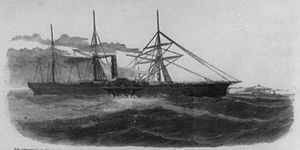
- September 13, 1857 – A moderate hurricane brushes the Outer Banks, which causes high tides and several shipwrecks; the SS Central AmericaSS Central AmericaSS Central America, sometimes called the Ship of Gold, was a 280-foot sidewheel steamer that operated between Central America and the eastern coast of the United States during the 1850s. She was originally named the SS George Law, after Mr. George Law of New York...
capsizes a short distance offshore, resulting in 424 deaths and contributing to the Panic of 1857Panic of 1857The Panic of 1857 was a financial panic in the United States caused by the declining international economy and over-expansion of the domestic economy. Indeed, because of the interconnectedness of the world economy by the time of the 1850s, the financial crisis which began in the autumn of 1857 was...
. - September 16, 1858 – A hurricane brushes the Outer Banks.
- September 17, 1859 – A tropical storm crosses through the state, producing light winds and rainfall.
1860–1869
- September 27, 1861 – A fast moving hurricane moves ashore near Wilmington.
- October 7, 1861 – The Outer Banks are affected by a tropical storm.
- November 2, 1861 – The Expedition Hurricane crosses the Outer Banks during the American Civil WarAmerican Civil WarThe American Civil War was a civil war fought in the United States of America. In response to the election of Abraham Lincoln as President of the United States, 11 southern slave states declared their secession from the United States and formed the Confederate States of America ; the other 25...
, which scatters a UnionUnion (American Civil War)During the American Civil War, the Union was a name used to refer to the federal government of the United States, which was supported by the twenty free states and five border slave states. It was opposed by 11 southern slave states that had declared a secession to join together to form the...
fleet of 75 ships off Cape Hatteras; at least two vessels sink, causing seven deaths, and several other ships are wrecked by Confederate forcesConfederate States of AmericaThe Confederate States of America was a government set up from 1861 to 1865 by 11 Southern slave states of the United States of America that had declared their secession from the U.S...
during the storm. - September 18, 1863 – A tropical storm crosses the eastern portion of the state.
- October 29, 1866 – A hurricane passes just east of the state.
- June 23, 1867 – The remnants of a tropical storm being heavy rainfall to the central portion of the state.
- August 1, 1867 – A hurricane recurves just to the east of the state.
- October 5, 1868 – A tropical storm parallels the entire coastline just offshore.
1870–1879
- August 18, 1871 – Looping to the south of the state and striking Georgia, a tropical storm produces gale force winds and high tides near Wilmington, which capsizes two small vessels.
- August 29, 1871 – A tropical storm parallels the coastline just offshore.
- October 24, 1872 – Wilmington is struck by a tropical storm.
- September 28, 1874 – After moving ashore along South Carolina, a hurricane causes locally severe damage near Wilmington, where its passage results in uprooted trees and several destroyed houses; the hurricane produces high tides, which destroys multiple railroad bridges.
- September 19, 1875 – The remnants of a major hurricane that strikes Indianola, TexasIndianola, TexasIndianola is a ghost town located on Matagorda Bay in Calhoun County, Texas, United States. The community, once the county seat of Calhoun County, is a part of the Victoria, Texas, Metropolitan Statistical Area. In 1875, the city had a population of 5,000, but on September 15 of that year, a...
pass through the state. - September 17, 1876 – A hurricane moves ashore near Wilmington, causing localized severe damage and capsizing several ships; a military camp is destroyed by the storm, and two people drown during the storm.
- September 29, 1877 – An offshore tropical storm drops moderate precipitation in the southern portion of the state.
- October 4, 1877 – After striking Florida as a hurricane, a tropical storm transitions into an extratropical cycloneExtratropical cycloneExtratropical cyclones, sometimes called mid-latitude cyclones or wave cyclones, are a group of cyclones defined as synoptic scale low pressure weather systems that occur in the middle latitudes of the Earth having neither tropical nor polar characteristics, and are connected with fronts and...
over the state, which causes severe flooding and winds in the vicinity of the Albemarle Sound. - September 12, 1878 – A tropical storm passes through the state, while offshore several vessels are wrecked.
- October 11, 1878 – A tropical storm brushes the coastline.
- October 23, 1878 – The Gale of 1878Gale of 1878The Gale of 1878, was an intense Category 2 hurricane that caused extensive damage from Cuba to New England.-Meteorological history:A tropical storm formed off the coast of Jamaica on October 18, 1878, and moved nearly due north. On October 20, the storm reached hurricane status and on October 21,...
moves ashore, producing winds of up to 100 mph (160 km/h) and causing mariner losses along the coast; at least four casualties are reported, and damage amounts to $200,000 (1878 USD, $4.3 million 2007 USD). - August 18, 1879 – A major hurricane crosses the eastern portion of the state, with its accompanying high waves and tides destroying several wharves and bridges along the coastline; damage is greatest near Morehead City.
1880–1889
- September 9, 1880 – The Outer Banks are struck by a minimal hurricane.
- August 28, 1881 – A moderate hurricane moves ashore near Savannah, Georgia, which produces gales in southern North Carolina.
- September 9, 1881 – Wilmington is struck by what is considered the most severe hurricane in over 40 years; strong winds from the storm wreck buildings and trees, and damage from the cyclone totals $100,000 (1881 USD, $2.1 million 2007 USD).
- September 11, 1882 – After making landfall on Florida as a major hurricane, a tropical storm passes through central North Carolina, causing gusty winds near the coastline and widespread damage.
- September 22, 1882 – A tropical storm crosses the Outer Banks and drops locally heavy rainfall.
- October 12, 1882 – Paralleling the coastline a short distance offshore, a hurricane brushes the state with gusty winds and moderate rainfall.
- September 11, 1883 – A hurricane moves ashore just east of the South Carolina/North Carolina border, causing strong winds and wrecking several vessels along the coastline; there are 53 deaths in the state.
- August 25, 1885 – A hurricane crosses through the southeastern portion of the state with peak wind gusts estimated at over 125 mph (200 km/h) in Smithville; there, damage amounts to over $100,000 (1885 USD, $2.3 million 2007 USD).
- September 22, 1885 – A tropical storm brushes the coastline.
- October 2, 1885 – The Outer Banks are brushed by a hurricane.
- October 13, 1885 – A tropical storm crosses the central portion of the state, which causes gales and high tides along the coastline.
- June 22, 1886 – Heavy precipitation and unsettled conditions are associated with a tropical storm passing through the state.
- July 1, 1886 – Similar to the previous storm, a tropical storm produces gusty winds and light rainfall while passing through the state.
- August 20, 1887 – A major hurricane parallels the coastline offshore, destroying several houses and wrecking several boats.
- August 24, 1887 – Just days after the previous storm, another major hurricane parallels the coastline, though information is scarce due to downed communications from the previous storm.
- October 20, 1887 – A tropical depression becomes extratropical over the state, and causes light damage.
- October 31, 1887 – An offshore tropical storm downs telegraph lines in the Outer Banks.
- September 10, 1888 – A tropical storm crosses the central portion of the state.
- October 11, 1888 – The Outer Banks are hit by a tropical storm.
- November 25, 1888 – A moderate hurricane passes to the east of the state, bringing high tides and destructive winds.
- June 18, 1889 – A tropical storm brushes the coastline.
- September 12, 1889 – A tropical storm dissipates northeast of Virginia after persisting offshore for several days; the storm causes high tides, and a new inlet is cut through Nags Head.
- September 24, 1889 – Crossing through the central portion of the state, a tropical storm produces gusty winds and rough seas.
1890–1899
- October 11, 1891 – The extratropical remnants of a tropical storm produces gales along the coastline.
- June 16, 1893 – While crossing the state, a tropical storm drops heavy rainfall along the coastline.
- August 20, 1893 – An offshore hurricane brings heavy rainfall to the coastline.
- August 23, 1893 – The Outer Banks are brushed by a hurricane.
- August 28, 1893 – The Sea Islands hurricane1893 Sea Islands HurricaneOn August 27, 1893 a major hurricane which came to be known as the Sea Islands Hurricane struck the United States near Savannah, Georgia. It was one of two deadly hurricanes during the 1893 Atlantic hurricane season; the storm killed an estimated 1,000–2,000 people, mostly from storm surge...
moves ashore near the Georgia/South Carolina border as a major hurricane and later crosses through central North Carolina; it produces strong winds near the coast, which wreck a number of ships, while further inland the storm drops heavy rainfall. The hurricane damages or destroys hundreds of buildings, and kills one person near Kernersville. - October 4, 1893 – The remnants of what was once the Cheniere Caminada hurricane pass through the state as a tropical storm.
- October 13, 1893 – A major hurricane moves ashore near the South Carolina/North Carolina border, producing record high tides in Wilmington that causes heavy coastal damage; damage to the Wilmington waterfront totals $150,000 (1893 USD, $3.4 million 2007 USD). A total of 22 lives are lost in the state due to the hurricane.
- October 23, 1893 – A tropical storm brushes the Outer Banks.
- September 28, 1894 – Paralleling the coastline a short distance inland, a tropical storm wrecks several schooners near Cape Fear and Ocracoke.
- October 9, 1894 – A tropical storm crosses the eastern portion of the state.
- July 8, 1896 – The remnants of a tropical storm spawn several tornadoes in the state.
- September 8, 1896 – An offshore hurricane brushes the Outer Banks.
- September 29, 1896 – A hurricane crosses the state, causing overall light damage.
- October 11, 1896 – An offshore hurricane brushes the Outer Banks.
- September 23, 1897 – Paralleling the coastline just offshore, a tropical storm produces gusty winds and high tides.
- October 20, 1897 – Light to moderate precipitation is reported in association with an offshore tropical storm.
- October 26, 1897 – After executing a counter-clockwise loop, a tropical storm hits the Outer Banks from the northeast before continuing southeastward; its effects are minimal.
- October 2, 1898 – A major hurricane that strikes Georgia, and produces heavy surf in along the Carolina coastline.
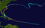
- August 18, 1899 – The San Ciriaco Hurricane1899 Hurricane San Ciriaco1899 San Ciriaco hurricane, also known as the 1899 Puerto Rico Hurricane, was the longest-lived Atlantic hurricane and the eleventh deadliest tropical cyclone in the basin. It was an intense and long-lived Atlantic Cape Verde-type hurricane which crossed Puerto Rico over the two day period August 8...
moves slowly ashore along the Outer Banks, after previously causing extreme damage in Puerto Rico. Nearly all of Hatteras Island is covered with a 4 foot (1.2 m) storm tide, and about 10 vessels are wrecked. Damage is severe across the eastern portion of the state, and over 20 people are killed in the state. - October 6, 1899 – The extratropical remnants of a tropical storm brush the state.
- October 31, 1899 – A moderate hurricane moves ashore just southwest of the South Carolina/North Carolina border, resulting in high tides and one ship wreck; one person is killed in association with the storm.
Monthly statistics
| Month | Number of recorded storms affecting North Carolina |
|---|---|
| June | 8 |
| July | 6 |
| August | 41 |
| September | 46 |
| October | 36 |
| November | 2 |
Deadly storms
The table lists hurricanes by death tolls; hurricanes that caused an unknown number of deaths are excluded.| Name | Year | Number of deaths |
|---|---|---|
| Unnamed | 1857 | 424 |
| Independence Hurricane | 1775 | 163 |
| Racer's Storm 1837 Racer's Storm The 1837 Racer's Storm was one of the most powerful and destructive hurricanes in the 19th century, causing heavy damage to many cities on its 2,000+ mile path... |
1837 | 90 |
| Unnamed | 1883 | 53 |
| Unnamed | 1772 | 50 |
| San Ciriaco 1899 Hurricane San Ciriaco 1899 San Ciriaco hurricane, also known as the 1899 Puerto Rico Hurricane, was the longest-lived Atlantic hurricane and the eleventh deadliest tropical cyclone in the basin. It was an intense and long-lived Atlantic Cape Verde-type hurricane which crossed Puerto Rico over the two day period August 8... |
1899 | 20+ |
| Unnamed | 1842 | 8 |
| Expedition Hurricane | 1861 | 7 |
| Unnamed | 1815 | 4 |
| Unnamed Gale of 1878 The Gale of 1878, was an intense Category 2 hurricane that caused extensive damage from Cuba to New England.-Meteorological history:A tropical storm formed off the coast of Jamaica on October 18, 1878, and moved nearly due north. On October 20, the storm reached hurricane status and on October 21,... |
1878 | 4 |
| Unnamed | 1827 | 2 |
| Unnamed | 1876 | 2 |
| Unnamed | 1899 | 1 |
See also
- List of North Carolina hurricanes
- Geography of North CarolinaGeography of North CarolinaThe Geography of North Carolina falls naturally into three divisions or sections—the Appalachian Mountains formed mostly by the Blue Ridge and Great Smoky Mountains, the Middle or Piedmont Plateau, and the Eastern or Tidewater section, also known as the Coastal Plain. North Carolina covers and is ...