

List of Connecticut rivers
Encyclopedia
List of river
s in Connecticut
(U.S. state
), sorted by drainage basin.
All of Connecticut's rivers flow into Long Island Sound
and from there the waters mix into the Atlantic Ocean
. The list is arranged by drainage basin from east to west, with respective tributaries indented from downstream to upstream under each larger stream's name.
By drainage basin

River
A river is a natural watercourse, usually freshwater, flowing towards an ocean, a lake, a sea, or another river. In a few cases, a river simply flows into the ground or dries up completely before reaching another body of water. Small rivers may also be called by several other names, including...
s in Connecticut
Connecticut
Connecticut is a state in the New England region of the northeastern United States. It is bordered by Rhode Island to the east, Massachusetts to the north, and the state of New York to the west and the south .Connecticut is named for the Connecticut River, the major U.S. river that approximately...
(U.S. state
U.S. state
A U.S. state is any one of the 50 federated states of the United States of America that share sovereignty with the federal government. Because of this shared sovereignty, an American is a citizen both of the federal entity and of his or her state of domicile. Four states use the official title of...
), sorted by drainage basin.
All of Connecticut's rivers flow into Long Island Sound
Long Island Sound
Long Island Sound is an estuary of the Atlantic Ocean, located in the United States between Connecticut to the north and Long Island, New York to the south. The mouth of the Connecticut River at Old Saybrook, Connecticut, empties into the sound. On its western end the sound is bounded by the Bronx...
and from there the waters mix into the Atlantic Ocean
Atlantic Ocean
The Atlantic Ocean is the second-largest of the world's oceanic divisions. With a total area of about , it covers approximately 20% of the Earth's surface and about 26% of its water surface area...
. The list is arranged by drainage basin from east to west, with respective tributaries indented from downstream to upstream under each larger stream's name.
By drainage basinDrainage basinA drainage basin is an extent or an area of land where surface water from rain and melting snow or ice converges to a single point, usually the exit of the basin, where the waters join another waterbody, such as a river, lake, reservoir, estuary, wetland, sea, or ocean...
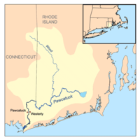
- Pawcatuck RiverPawcatuck RiverThe Pawcatuck River is a river in the U.S. states of Rhode Island and Connecticut flowing approximately . There are eight dams along the river's length. The former USS Pawcatuck was named after the river.-History:...
- Shunock River
- Ashaway RiverAshaway RiverThe Ashaway River is a river in the U.S. state of Rhode Island. It flows approximately 4 km . There are three dams along the river's length.- Course :The river is formed in Hopkinton by the confluence of Parmenter Brook and the Green Fall River...
(Rhode Island)- Green Fall RiverGreen Fall RiverThe Green Fall River is a river in the U.S. states of Connecticut and Rhode Island. It flows approximately 13 km .-Course:The river rises from a swamp south of Rockville Road in Voluntown...
- Green Fall River
- Wood River
- Mystic RiverMystic River (Connecticut)The Mystic River is a estuary in the southeast corner of the U. S. state of Connecticut. Its main tributary is Whitford Brook. It empties into Fishers Island Sound, dividing the village of Mystic between the towns of Groton and Stonington. Much of the river is tidal...
- Whitford Brook
- Poquonock River
- Thames RiverThames River (Connecticut)The Thames River is a short river and tidal estuary in the U.S. state of Connecticut. It flows south for through eastern Connecticut from the junction of the Yantic and Shetucket rivers at Norwich, to New London and Groton, which flank its mouth at the Long Island Sound.Differing from its...
- Oxoboxo RiverOxoboxo RiverOxoboxo River is a census-designated place in the town of Montville in New London County, Connecticut, United States. The population was 2,938 at the 2000 census and 3,165 at the 2010 census. The statistical area encompasses the town center of Montville, as well as the adjacent villages of...
- Shetucket RiverShetucket RiverThe Shetucket River is a tributary of the Thames River, long, in eastern Connecticut in the United States.It is formed at Willimantic by the junction of the Willimantic and Natchaug rivers. It flows southeast and south...
- Quinebaug RiverQuinebaug RiverThe Quinebaug River is a river in south-central Massachusetts and eastern Connecticut, with watershed extending into western Rhode Island. The name "Quinebaug" comes from the southern New England Native American term, spelled variously Qunnubbâgge, Quinibauge, etc., meaning "long pond", from...
- Pachaug RiverPachaug RiverThe Pachaug River is a river arising from the Pachaug State Forest at the Connecticut - Rhode Island border and draining into the Quinebaug River....
- Blackwell Brook
- Moosup RiverMoosup RiverThe Moosup River is a river in the U.S. states of Rhode Island and Connecticut. It flows approximately .-Course:The river rises from Clark Pond in Foster, Rhode Island...
- Fivemile RiverFive Mile RiverThe Five Mile River is a river approximately long, located in Connecticut's Northeast Corner. The original Nipmuc name was Assawaga, meaning "place between" or "halfway place." The Assawaga received its English name from the fact that the first land laid out upon it was "supposed to be about five...
- Little River (Quinebaug River)
- French RiverFrench River (Massachusetts)The French River is a river in south-central Massachusetts and northeastern Connecticut.The river rises near Leicester, Massachusetts, and flows generally southwards through Auburn, Oxford, and Dudley; it then enters Connecticut where it joins the Quinebaug River at Thompson, just northeast of Putnam...
- Pachaug River
- Little River (Shetucket River)
- Natchaug RiverNatchaug RiverThe Natchaug River is a river in Windham and Tolland Counties in Connecticut.The Natchaug River is formed in Eastford, Connecticut at the confluence of Bigelow Brook and the Still River. It then flows to the south, paralleling Connecticut Route 198. The river also runs along the western border...
- Mount Hope River
- Fenton River
- Still River (Natchaug River)
- Mount Hope River
- Willimantic RiverWillimantic RiverThe Willimantic River is a tributary of the Shetucket River, approximately 25 mi long in northeastern Connecticut in the New England region of the United States....
- Tenmile River
- Hop RiverHop RiverThe Hop Rivers marshy source is just southeast of Bolton Notch, Connecticut. It flows for about to its confluence with the Willimantic River. There is a popular paddling route beginning where the Skungamaug River enters the Hop River just north of the Hendee Road bridge and ending at the...
- Skungamaug River
- Quinebaug River
- Yantic RiverYantic RiverThe Yantic River forms at the confluence of the Deep River, Sherman Brook, and Exeter Brook about east of Colchester, Connecticut. It runs for and flows into the Shetucket River in Norwich, forming the Thames River...
- Oxoboxo River
- Niantic RiverNiantic RiverThe Niantic River is a mainly tidal river in eastern Connecticut. It is crossed by the Niantic River Bridge carrying Amtrak's Northeast Corridor, as well as highway bridges carrying Connecticut Route 156 and US-1. It separates the towns of East Lyme and Waterford. The river is long....
- Pattagansett River
- Fourmile River
- Threemile River
- Black Hall River
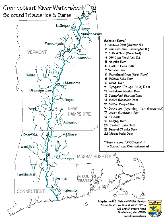
- Connecticut RiverConnecticut RiverThe Connecticut River is the largest and longest river in New England, and also an American Heritage River. It flows roughly south, starting from the Fourth Connecticut Lake in New Hampshire. After flowing through the remaining Connecticut Lakes and Lake Francis, it defines the border between the...
- Back River
- Lieutenant RiverLieutenant RiverThe Lieutenant River is a tidal river located in Old Lyme, Connecticut. It joins the Connecticut River in the estuary, just above the point where that river flows into Long Island Sound....
- Falls RiverFalls River (Connecticut River)The Falls River is a river located in Essex, Connecticut. It begins in the Pond Meadow area of Ivoryton and runs for about through Essex. Its beginnings are visible from Comstock Field at the end of Park Road in Ivoryton. Before that it runs to a small pond behind the L.C. Doane Company near Pond...
- Eightmile River
- Deep River
- Salmon RiverSalmon River (Connecticut)The Salmon River is formed at the confluence of the Blackledge and Jeremy rivers about one mile west of North Westchester, Connecticut. It runs for to Salmon Cove near Moodus where it flows into the Connecticut River....
- Moodus River
- Blackledge RiverBlackledge RiverThe Blackledge River begins southeast of Manchester, Connecticut just north of Route 534 in a gully near Converse Road. The Blackledge runs for until it flows into the Salmon River. A popular whitewater paddling route begins at West Road about south of Gay City State Park...
- Jeremy RiverJeremy RiverThe Jeremy River begins at a drainage just north of Holbrook Pond about east of Gilead, Connecticut and runs for to the Salmon River. There are many swamps and marshes along the banks of its northern end, the largest of which is long....
- Sumner Brook
- Pameacha CreekPameacha CreekPameacha Creek is a stream in Middletown, Connecticut....
- Pameacha Creek
- Mattabesset River
- Coginchaug RiverCoginchaug RiverThe Coginchaug River in Connecticut, with a watershed of including forests, pastures, farmland, industrial, and commercial areas, is the predominant tributary of the Mattabesset River...
- Coginchaug River
- Hockanum RiverHockanum RiverThe Hockanum River is a river in Connecticut. The Hockanum neighborhood in East Hartford is named after it.It rises at the outlet of Shenipsit Lake in Rockville, then flows through Vernon, Manchester, and East Hartford...
- Tankerhoosen River
- Park RiverPark River (Connecticut)The Park River, sometimes called the Hog River, is a subterranean urban river that flows through and under the city of Hartford, Connecticut. It was diverted underground by the Army Corps of Engineers in 1940. The stated reason for this was to reduce the risk of spring seasonal floods which had...
(also known as Hog River and Little River)- North Branch Park River
- South Branch Park River
- Podunk River
- Farmington RiverFarmington RiverThe Farmington River is a river located in northwest Connecticut, with major tributaries extending into southwest Massachusetts. Via its longest branch , the Farmington's length increases to , making it the Connecticut River's longest tributary by a mere over the major river directly to its...
- Pequabu River
- Pequabuck River
- Nepaug RiverNepaug RiverThe Nepaug River begins at the confluence of North Nepaug Brook and Cedar Swamp Brook about 1 mile east of Bakersville, Connecticut. It runs for to the Farmington River about a half mile south of Cherry Brook, Connecticut. A large dam about 1 mile from the Farmington River creates Nepaug...
- Poland River
- East Branch Farmington River
- Hubbard RiverHubbard RiverThe Hubbard River, long, is part of the Farmington River watershed. It is a main feature of Granville State Forest where it drops in . It is named for Samuel Hubbard, the English colonist who first came to the area in 1749...
- Hubbard River
- West Branch Farmington River
- Still River
- Mad River
- Still River
- Pequabu River
- Scantic RiverScantic RiverThe Scantic River is a river that flows through the states of Massachusetts and Connecticut and is tributary to the Connecticut River.The Scantic River's tributaries rise in the towns of Hampden, Wilbraham, East Longmeadow and Monson in Massachusetts, and in Stafford and Somers, Connecticut,...
- Watchaug River
- Patchogue River
- Menunketesuck River
- Indian River (Clinton)
- Hammonasset RiverHammonasset RiverThe Hammonasset River is formed about southeast of Durham, Connecticut along a gully on the north end of Bunker Hill at about a half mile northeast of the junction of Route 148 and Bunker Hill Road. The river travels for to Clinton Harbor on Long Island Sound just east of Hammonasset Beach State...
- Neck River
- East River
- West River (Guilford)
- Branford River
- Farm River
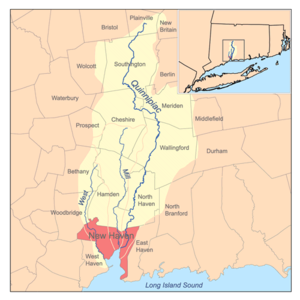
- Quinnipiac RiverQuinnipiac RiverThe Quinnipiac River is a river in the New England region of the United States, located entirely in the state of Connecticut.It rises in west central Connecticut from Dead Wood Swamp west of the city of New Britain...
- Muddy River
- Tenmile River
- Eightmile River
- Mill River
- West RiverWest River (Connecticut)The West River is a freshwater stream in southern Connecticut. It flows through the towns of Bethany, Woodbridge, and New Haven before discharging into the West Haven Harbor....
- Sargent River
- Cove River
- Oyster RiverOyster River (Connecticut)The Oyster River is a stream located in the state of Connecticut in New Haven County. It flows south through Orange and forms the boundary of West Haven and Orange and further downstream the boundary of West Haven and Milford. It empties into Long Island Sound, just south of Route 162 at Oyster...
- Indian River (Milford)
- Wepawaug River
- Housatonic RiverHousatonic RiverThe Housatonic River is a river, approximately long, in western Massachusetts and western Connecticut in the United States. It flows south to southeast, and drains about of southwestern New England into Long Island Sound...
- Farmill River
- Naugatuck RiverNaugatuck RiverThe Naugatuck River is a river in the US state of Connecticut. It carves out the Naugatuck River Valley. The river flows from northwest Connecticut southward into the Housatonic River in Derby, Connecticut. One of the river's main uses is hydropower, which is used to power industrial plants...
- Mad River
- Halfway River
- Pomperaug RiverPomperaug RiverThe Pomperaug River is a river in the US state of Connecticut. The two main tributaries to the Pomperaug are the Nonnewaug River and the Weekeepeemee River. It is at the confluence of these two rivers in Woodbury that the Pomperaug forms...
- Nonewaug River
- Weekeepeemee River
- Pootatuck River
- Shepaug RiverShepaug RiverThe Shepaug River is a river in Connecticut, in the United States. The river originates in Warren and runs south through Washington, Roxbury, and Southbury, where it empties into the Housatonic River at Lake Lillinonah , thereafter flowing into the Long Island Sound...
- Bantam River
- Marshepaug River
- Still River
- West Aspetuck River
- East Aspetuck RiverEast Aspetuck RiverThe East Aspetuck River is a river in Litchfield County, Connecticut, in the United States. It begins at Lake Waramaug, in the town of Washington, and flows south through New Preston and Northville, before emptying into the Housatonic River in New Milford....
- East Aspetuck River
- Rocky RiverRocky River (Connecticut)The Rocky River is very short and small tributary of the Housatonic River in the U.S. state of Connecticut. It flows into the Housatonic River from the west just upstream from New Milford at...
- Ten Mile RiverTen Mile River (Connecticut)The Ten Mile River is a river that flows through Dutchess County, New York into westernmost Connecticut. The river is formed in the town of Amenia, New York, at the confluence of Webatuck Creek, which forms in Connecticut, and Wassaic Creek, which forms in New York...
- Hollenbeck River
- Blackberry River
- Whiting River
- Konkapot RiverKonkapot RiverThe Konkapot River is a river in southwestern Massachusetts and northern Connecticut. It is a tributary of the Housatonic River, not to be confused with the smaller Konkapot Brook in Stockbridge ....
- Pequonnock RiverPequonnock RiverThe Pequonnock River is a waterway in eastern Fairfield County, Connecticut, flowing through the city of Bridgeport. The river has a penchant for flooding, particularly in spring since the removal of a retention dam in Trumbull in the 1950s. There seems to be a sharp difference of opinion among...
- Rooster RiverRooster RiverRooster River is a river in Fairfield County, Connecticut that lies on and serves as the border between Bridgeport and Fairfield. It has flooded on numerous occasions and so has its own flood control project....
- Mill River
- Saugatuck RiverSaugatuck RiverThe Saugatuck River is a river in southwestern Connecticut in the United States. It drains part of suburban and rural Fairfield County west of Bridgeport, emptying into Long Island Sound.-Description:...
- West Branch Saugatuck River
- Aspetuck RiverAspetuck RiverThe Aspetuck River is a river in the U.S. state of Connecticut. The river rises in the hills located in Huntington State Park in Bethel, with a watershed of approximately . The river flows generally southerly through Redding, Connecticut to the Aspetuck Reservoir, the Hemlock Reservoir in Easton...
- Little River
- Norwalk RiverNorwalk RiverThe Norwalk River is a river in southwestern Connecticut, approximately long. The word "Norwalk" comes from the Algonquian word "noyank" meaning "point of land".-Description:...
- Silvermine RiverSilvermine RiverThe Silvermine River is an river in Norwalk and New Canaan, Connecticut. It is spanned by the 1899 Perry Avenue Bridge in the Silvermine neighborhood, and by the Silvermine River Bridge that carries the Merritt Parkway. It is a tributary of the Norwalk River which it joins at the north end of...
- Silvermine River
- Fivemile River
- Noroton RiverNoroton RiverThe Noroton River is a stream flowing into Holly Pond and forming most of the border between Stamford and Darien, Connecticut, USA. The river's headwaters are in New Canaan, Connecticut...
- Rippowam RiverRippowam RiverThe Rippowam River is a river in Fairfield County, Connecticut. It drains a watershed area of and flows for from Ridgefield to Long Island Sound, which it enters in Stamford's harbor....
(also known as "Mill River" in its lower end in StamfordStamford, ConnecticutStamford is a city in Fairfield County, Connecticut, United States. According to the 2010 census, the population of the city is 122,643, making it the fourth largest city in the state and the eighth largest city in New England...
) - Mianus RiverMianus RiverThe Mianus River is a river in Westchester County, New York and Fairfield County, Connecticut, in the United States. It begins in the town of North Castle, New York in a series of ponds at about altitude...
- Byram RiverByram RiverThe Byram River is a river approximately in length, in southeast New York and southwestern Connecticut in the United States.The river has an elevation of at its headwaters at Byram Lake in Westchester County, New York, and flows in a southward direction, crossing the New York-Connecticut border...
- Hudson RiverHudson RiverThe Hudson is a river that flows from north to south through eastern New York. The highest official source is at Lake Tear of the Clouds, on the slopes of Mount Marcy in the Adirondack Mountains. The river itself officially begins in Henderson Lake in Newcomb, New York...
(New York)- Croton RiverCroton RiverThe Croton River is a river in southern New York that begins where the East and West Branches of the Croton River meet a little way downstream from the Croton Falls Reservoir...
(New York)- Titicus RiverTiticus RiverThe Titicus River is an 8.5 mile river in southwestern Connecticut and southeastern New York that drains in to the Titicus Reservoir, part of New York City's water supply system. The drainage area is . It is one of the few rivers in Connecticut that is part of the system. The source of the river is...
- Titicus River
- Croton River