

West River (Connecticut)
Encyclopedia
Connecticut
Connecticut is a state in the New England region of the northeastern United States. It is bordered by Rhode Island to the east, Massachusetts to the north, and the state of New York to the west and the south .Connecticut is named for the Connecticut River, the major U.S. river that approximately...
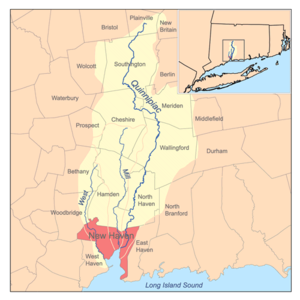
. It flows through the towns of Bethany
Bethany, Connecticut
Bethany is a town in New Haven County, Connecticut, United States. The population was 5,040 at the 2000 census. Bethany was first settled in 1717 but it was not until May 1832 that Bethany separated from Woodbridge to become incorporated as a town. This slightly remote, sparsely populated,...
, Woodbridge
Woodbridge, Connecticut
Woodbridge is a town in New Haven County, Connecticut, United States. The population was 8,983 at the 2000 census. It is one of the wealthiest towns in Connecticut, ranking 16th in the state in terms of per capita income, and is home to many of the faculty of Yale University...
, and New Haven
New Haven, Connecticut
New Haven is the second-largest city in Connecticut and the sixth-largest in New England. According to the 2010 Census, New Haven's population increased by 5.0% between 2000 and 2010, a rate higher than that of the State of Connecticut, and higher than that of the state's five largest cities, and...
before discharging into the West Haven
West Haven, Connecticut
West Haven is a city in New Haven County, Connecticut, United States. According to 2006 Census Bureau estimates, the population of the city is 52,721.-History:...
Harbor.
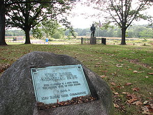
Within the city of New Haven, the river is surrounded by Edgewood Park and the West River Memorial Park along much of its length.. While the river's natural channel winds along the western edge of the West River Memorial Park, a very straight channel cuts through its middle and terminates at the park's northern edge (Derby Avenue). This channel was constructed for aesthetic purposes. There is a public canoe launch, maintained by the City of New Haven Department of Parks, Recreation, and Trees, in the constructed channel at Derby Avenue.
Dams
The river is dammed in several places and some of the reservoirs are used by the South Central Connecticut Regional Water AuthoritySouth Central Connecticut Regional Water Authority
The South Central Connecticut Regional Water Authority is a public water supply utility in Connecticut, United States.The Authority supplies water in a 15-town region with a population of about 400,000. Historically it was the water supplier in the towns of Bethany, Branford, Cheshire, East Haven,...
to provide a percentage of the public water supply. The reservoirs are named Lily Pond (or Pond Lily), Konolds Pond, Lake Dawson, Lake Watrous, and Lake Bethany, in order from south to north.
Tide gate
The river flows through a tide gate where it crosses under Orange Avenue (U.S. 1U.S. Route 1 in Connecticut
In the U.S. state of Connecticut, U.S. Route 1 is a major east–west state highway along Long Island Sound. It has been replaced by Interstate 95 as a through route, which it closely parallels, and now primarily serves as a local business route...
, also referred to as the Boston Post Road
Boston Post Road
The Boston Post Road was a system of mail-delivery routes between New York City and Boston, Massachusetts that evolved into the first major highways in the United States.The three major alignments were the Lower Post Road The Boston Post Road was a system of mail-delivery routes between New York...
). Under unaltered conditions, the river would likely be brackish
Brackish water
Brackish water is water that has more salinity than fresh water, but not as much as seawater. It may result from mixing of seawater with fresh water, as in estuaries, or it may occur in brackish fossil aquifers. The word comes from the Middle Dutch root "brak," meaning "salty"...
along much of its length due to salt water mixing at high tide. The tide gate prevents this from happening by only allowing water past at low tide. The gate was installed with the goal of controlling flooding in mind, however, after heavy rains, the gate often exacerbates flooding, as it prevents drainage during high tide. The large quantity of Phragmites australis
Phragmites
Phragmites, the Common reed, is a large perennial grass found in wetlands throughout temperate and tropical regions of the world. Phragmites australis is sometimes regarded as the sole species of the genus Phragmites, though some botanists divide Phragmites australis into three or four species...
, or common reed, growing along the river's banks can most likely be attributed to the tide gate. Phragmites cannot tolerate high salinity
Salinity
Salinity is the saltiness or dissolved salt content of a body of water. It is a general term used to describe the levels of different salts such as sodium chloride, magnesium and calcium sulfates, and bicarbonates...
, and the tide gate maintains the river's salinity at a level low enough for the plant to survive.