

Lake Faguibine
Encyclopedia
Mali
Mali , officially the Republic of Mali , is a landlocked country in Western Africa. Mali borders Algeria on the north, Niger on the east, Burkina Faso and the Côte d'Ivoire on the south, Guinea on the south-west, and Senegal and Mauritania on the west. Its size is just over 1,240,000 km² with...
on the southern edge of the Sahara
Sahara
The Sahara is the world's second largest desert, after Antarctica. At over , it covers most of Northern Africa, making it almost as large as Europe or the United States. The Sahara stretches from the Red Sea, including parts of the Mediterranean coasts, to the outskirts of the Atlantic Ocean...
Desert situated 80 km west of Timbuktu
Timbuktu
Timbuktu , formerly also spelled Timbuctoo, is a town in the West African nation of Mali situated north of the River Niger on the southern edge of the Sahara Desert. The town is the capital of the Timbuktu Region, one of the eight administrative regions of Mali...
and 75 km north of the Niger River
Niger River
The Niger River is the principal river of western Africa, extending about . Its drainage basin is in area. Its source is in the Guinea Highlands in southeastern Guinea...
to which it is connected by a system of smaller lakes and channels. In years when the height of the annual flood of the river is sufficient, water flows from the river into the lake. Since the Sahel drought
Sahel drought
[[File:Greening Sahel 1982-1999.jpg|thumb|300px|Recent "Greening" of the Sahel: The results of trend analyses of time series over the Sahel region of seasonally integrated NDVI using NOAA AVHRR NDVI-data from 1982 to 1999...
of the 1970s and 1980s the lake has been mostly dry. Water has only rarely reached the lake and even when it has done so, the lake has been only partially filled with water. This has caused a partial collapse of the local ecosystem.
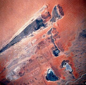
Lake Faguibine system
The lake forms part of a system of five interconnected low-lying depressionDepression (geology)
A depression in geology is a landform sunken or depressed below the surrounding area. Depressions may be formed by various mechanisms.Structural or tectonic related:...
s that fill to variable depths depending on the extent of the annual flood of the Niger River. Lake Faguibine is by far the largest of these depressions with an area of 590 km2. The low annual rainfall in the area (less than 200 mm) only has a marginal effect on the water levels in the depressions.
The depressions are connected to the Niger River by two channels. The more southerly Kondi channel (64 km in length) branches from the Niger a few kilometers downstream of Diré
Dire
As a location, Dire may refer to:*Diré, Mali*Dire – one of the 180 woredas in the Oromia Region of Ethiopia....
and then meanders across the Killi floodplain. The larger and more northerly Tassakane channel (104 km in length) branches from the Niger further downstream near Korioumé and then meanders across the Kessou floodplain. The two channels unite to form a single channel to the east of Goundam
Goundam
Goundam is a commune and town in north central Mali, in the Tombouctou Region. It is the capital of Goundam Cercle, one of five subdivisions of the Region. In the 2009 census the commune had a population of 16,253...
which after another 20 km flows into the southern end of Lake Télé. Lake Télé is connected at its northern end to Lake Takara. Water flows out of the northern end of Lake Takara, across a rocky sill at Kamaïna and then turns west passing the village of Bintagoungou
Bintagoungou
Bintagoungou is a rural commune and village of the Cercle of Goudam in the Tombouctou Region of Mali. The village lies at the south east corner of Lake Faguibine near the channel that connects Lake Faguibine to Lake Takara...
to reach Lake Faguibine.
Both Lake Télé and Lake Takara need to be completely filled before the water can flow over the sill at Kamaïna and begin to supply Lake Faguibine. In a similar manner two depressions to the east of Lake Faguibine (Lake Kamango and Lake Gouber) only start to fill once Lake Faguibine is full. To completely fill the 590 km2 of Lake Faguibine requires about 4 km3 of water. This represents around 17% of the average discharge of the Niger (1970-1998) at Diré.
The lake bed is very fertile and the ideal situation for the sedentary farmers is when the lake is only partially filled. This allows crops to be cultivated around the border of the lake and the growth of Echinochloa stagnina
Echinochloa stagnina
Echinochloa stagnina is a species of Echinochloa widespread in tropical Africa and Asia, with an invasive status in many Pacific islands....
("bourgou") in low lying areas to provide dry season pasture. This regime requires much less water – only around 0.5 km3.
River Niger and the annual flood
Niger River at Diré |
|---|
Average monthly flow (m³/s) at the Diré hydrometric station over the period 1924-1992 |
The filling of Lake Faguibine with water from the Niger River is dependent on the both the height of the annual flood and the free flow of water along the complex 170 km route linking the lake to the river. The annual flood of the Niger River is a result of the heavy rainfall in Guinea
Guinea
Guinea , officially the Republic of Guinea , is a country in West Africa. Formerly known as French Guinea , it is today sometimes called Guinea-Conakry to distinguish it from its neighbour Guinea-Bissau. Guinea is divided into eight administrative regions and subdivided into thirty-three prefectures...
and for its important tributary, the Bani River
Bani River
The Bani River is the principal tributary of the Niger River in Mali. Its length is about 1100 km. The Bani is formed from the confluence of the Baoulé and Bagoé rivers some 160 km east of Bamako and merges with the Niger near Mopti.-Geography:...
, that in northern Ivory Coast and southwest Mali. In all areas the rainfall peaks in the month of August. The amount of rain, and thus the height of the flood, varies from year to year. In years with high flood levels such as between 1924-1930 and 1951-1955 the lake is completely filled. In years with low rainfall the lake can dry out completely. In the 20th century this occurred in 1914, 1924 and 1944 and became a regular occurrence after the severe drought that began in the late 1970s. Low flood levels are exacerbated by the construction of dams on the Niger river or it tributaries that retain the floodwater and thus attenuate the maximum height of the flood downstream. Of the existing dams, the most significant is the Sélingué Dam
Selingue Dam
The Sélingué Dam is a single purpose hydroelectric dam located in the Koulikoro Region, on the Sankarani River, one of the affluents of the Niger River...
on the Sankarani River
Sankarani River
The Sankarani River is a tributary of the Niger River Flowing northward from the Fouta Djallon highlands of Guinea, it crosses into southern Mali, where it joins the Niger approximately 40 km upstream of Bamako...
in southwest Mali that can store 2.2 km3 of water. There are plans to build a new large dam, the Fomi dam, on the Niandan tributary in Guinea that will store almost 3 times the amount of water as that stored by the Sélingué dam. If constructed this dam would further reduce the intensity of the annual flood.
One of the major aims of a United Nations Sudano-Sahelian Office (UNSO) project (1986-1990) was to improve the connection of the Niger with Lake Faguibine and to cut some of the meanders of the Kondi channel. The project was interrupted by the Tuareg Rebellion (1990–1995). During the 1980s the low height of the annual floods created intense competition for water and the local population obstructed the flow in the channels and installed fish-traps. Since 2003, a German aid organization, Mali-Nord, have financed the construction of irrigated areas that leave the flow of water in the channels unimpeded.
In 2006 the Government of Mali created the "Office pour la Mise en Valeur du système Faguibine" (OMVF) to maintain the channels and to stabilize the sand dunes by planting Euphorbia balsamifera
Euphorbia balsamifera
Euphorbia balsamifera is a plant in the Euphorbia genus. It is distributed from Arabian Peninsula to Sahara and Canary Islands....
and eucalyptus
Eucalyptus
Eucalyptus is a diverse genus of flowering trees in the myrtle family, Myrtaceae. Members of the genus dominate the tree flora of Australia...
.
Much of the vegetation that stabilized the dunes perished in the drought that started in the late 1970s. As a result sand is blown and washed into the channels. The sill at Kamaïna is next to large dunes and is particularly vulnerable to the accumulation of sand. Starting in 2002, the local villages cooperated in removing the sand and since 2006 the efforts have been coordinated by the OMVF and supported by the World Food Program. In October 2008, around a 1000 people worked for 6 days to clear the sand.
In a project funded by the government of Norway
Norway
Norway , officially the Kingdom of Norway, is a Nordic unitary constitutional monarchy whose territory comprises the western portion of the Scandinavian Peninsula, Jan Mayen, and the Arctic archipelago of Svalbard and Bouvet Island. Norway has a total area of and a population of about 4.9 million...
, the United Nations Environment Program is studying the Lake Faquibine ecosystem and looking at ways in which the management of land and the hydrological cycle could be improved. The project is planned to run between 2008 and 2015 with an initial budget of 1 million USD.
Annual maximum height (in meters) of the Niger River at the Diré hydrological station
External links
- Drying of Lake Faguibine at NASA Earth ObservatoryNASA Earth ObservatoryNASA Earth Observatory is an online publishing outlet for NASA which was created in 1999. It is the principal source of satellite imagery and other scientific information pertaining to the climate and the environment which are being provided by NASA for consumption by the general public...
. An incomplete draft dated 02-10-2008 of an English version of the Hamerlynck UNEP document. - Mali-Nord: a German foreign aid program funded by Gesellschaft für Technische Zusammenarbeit (GTZ) and Kreditanstalt für Wiederaufbau (KfW) that has been operating in northern Mali since 1994. Mostly in German but a few files in French and one in English by Andrew Dillon: Measuring the Programme Mali-Nord’s Impact.