

Bani River
Encyclopedia
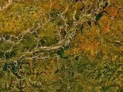
Tributary
A tributary or affluent is a stream or river that flows into a main stem river or a lake. A tributary does not flow directly into a sea or ocean...
of the Niger River
Niger River
The Niger River is the principal river of western Africa, extending about . Its drainage basin is in area. Its source is in the Guinea Highlands in southeastern Guinea...
in Mali
Mali
Mali , officially the Republic of Mali , is a landlocked country in Western Africa. Mali borders Algeria on the north, Niger on the east, Burkina Faso and the Côte d'Ivoire on the south, Guinea on the south-west, and Senegal and Mauritania on the west. Its size is just over 1,240,000 km² with...
. Its length is about 1100 km. The Bani is formed from the confluence
Confluence
Confluence, in geography, describes the meeting of two or more bodies of water.Confluence may also refer to:* Confluence , a property of term rewriting systems...
of the Baoulé and Bagoé
Bagoé River
The Bagoé River is a tributary of the Bani River in western Africa. It flows through northern Côte d'Ivoire and southern Mali and forms part of the international boundary between the two states....
rivers some 160 km east of Bamako
Bamako
Bamako is the capital of Mali and its largest city with a population of 1.8 million . Currently, it is estimated to be the fastest growing city in Africa and sixth fastest in the world...
and merges with the Niger near Mopti
Mopti
Mopti is a city at the confluence of the Niger and the Bani in Mali, between Timbuktu and Ségou. The city lies on three islands linked by dykes: the New Town, the Old Town and Medina Coura. As a result it is sometimes known as the "Venice of Mali".-History:The city of Mopti derives its name from...
.
Geography
The Bani River has three main tributaries: the Baoulé that rises near OdiennéOdienné
Odienné is the chief town of Odienné Department of Côte d'Ivoire, lying in the northwestern part of the country. West of Odienné is the Deng Kele Massif. The town of Odienné was founded by Malinké people under Vakaba Tourié . Later, Samory Touré founded a support base in the town. Features of...
in Côte d'Ivoire and passes just south of Bougouni
Bougouni
Bougouni is a commune and city in Mali, the administrative center of Bougouni Cercle, which is in turn found in the administrative region of Sikasso. Bougouni is located 170 km south of Bamako and 210 km west of the city of Sikasso...
, the Bagoé that rises near Boundiali
Boundiali
Boundiali is a town in Boundiali Department in north central Côte d'Ivoire, in the southwest of Savanes Region.Its population, the boundialikas, is made mainly of ethnic groups shared across the borders of Mali, Guinea, and Burkina Faso as well as some Fulas, totalling around 50,000 people in the...
in Côte d'Ivoire
Côte d'Ivoire
The Republic of Côte d'Ivoire or Ivory Coast is a country in West Africa. It has an area of , and borders the countries Liberia, Guinea, Mali, Burkina Faso and Ghana; its southern boundary is along the Gulf of Guinea. The country's population was 15,366,672 in 1998 and was estimated to be...
and the Banifing-Lotio that drains the region around Sikasso
Sikasso
Sikasso is a city in the south of Mali and the capital of the Sikasso Region. With 130,700 residents, Sikasso recently passed Ségou to become Mali's second-largest city.-Geography:...
. The drainage basin upstream of Douna has an area of 102,000 km2, 85% of which lies in southern Mali and 15% in northern Côte d'Ivoire.
The annual rainfall varies across the catchment basin with the southern area in Côte d'Ivoire receiving 1500 mm a year while the northern area around Douna receiving only 700 mm. For the period 1965-1995 the average annual rainfall for the basin was 1100 mm. The rainfall is seasonal with most of the rain falling between May and October. The maximum rainfall occurs in August.
The discharge of the Bani River is also highly seasonal, with the maximum flow occurring at the end of September and very little flow between
February and June. The river enters the Inland Niger Delta north of San and after the annual rains the river floods (the French word crue is sometimes used) and covers the floodplain.
There is a significant inter-annual variation in the rainfall and, as a consequence, in the quantity of water flowing in the river. The drought that started at the beginning of the 1970s lead to a very large reduction in the flow and up to the present time the volumes are still much lower than those observed in the 1950s and 1960s. The reduction in the flow of the river was much greater than the reduction in the rainfall. The average rainfall for 1981-1989 was 20% less than for 1961-1970 while the discharge of the river was reduced by 75%. The effect of the reduced rainfall was less extreme for other tributaries of the Niger. Over the same period the catchment basin of the Upper Niger suffered a similar 20% reduction in rainfall but the readings at the Koulikoro
Koulikoro
Koulikoro is a city in Mali. The capital of the Koulikoro Region, Koulikoro is located on banks of the Niger River, from Mali's capital Bamako....
gauge station were only reduced to 50% of the earlier values. Because of the accumulated groundwater deficit, even in a year with high rainfall, the discharge of the Bani River is less than in the wet decades of the 1950s and 1960s.
Talo Dam
In 2006 the Talo Dam was constructed to irrigate parts of the floodplain to the south of the river near the town of San. Prior to the construction of the dam, these areas were only fully flooded in very wet years, the most recent of which occurred in 1967. The dam is located 43 km west of San, 66 km downstream of Douna and 110 km upstream of DjennéDjenné
Djenné is an Urban Commune and town in the Inland Niger Delta region of central Mali. In the 2009 census the commune had a population of 32,944. Administratively it is part of the Mopti Region....
. The dam acts as a weir in that water can flow over the top of the retaining wall. The construction of the dam was highly controversial. The environmental impact assessment
Environmental impact assessment
An environmental impact assessment is an assessment of the possible positive or negative impact that a proposed project may have on the environment, together consisting of the natural, social and economic aspects....
commissioned by the African Development Bank
African Development Bank
The African Development Bank Group is a development bank established in 1964 with the intention of promoting economic and social development in Africa...
was criticised for not fully taking into account the hydrological impact downstream of the dam.
The retaining wall is 5 m high and 295 m in length, creating a reservoir with a capacity to retain 0.18 km3 of water. This volume represents 1.3% of the average annual discharge of the river (over the period 1952-2002 the average discharge was 13.4 km3). A downstream flow of 10 m3/s can be maintained during the dry season by opening a sluice gate. From the published information it is unclear how much of the total discharge will be diverted for irrigation and, of the diverted water, how much will drain back into the river. The downstream effect of the dam will be to delay the arrival of the annual flood and to reduce its intensity.
Djenné Dam
In May 2009 the African Development Bank approved funding for an irrigation dam/weir to be built on the Bani near Soala, a village situated 12 km south of Djenné. The dam is one element in a 6 year 66 million USD program that also includes the building of a dam on the Sankarani RiverSankarani River
The Sankarani River is a tributary of the Niger River Flowing northward from the Fouta Djallon highlands of Guinea, it crosses into southern Mali, where it joins the Niger approximately 40 km upstream of Bamako...
near Kourouba and the extension of the area irrigated by the Talo dam. The proposed Djenné dam will retain 0.3 km3 of water, significantly more than the Talo dam. It will allow the "controlled flooding" of 14,000 ha of the Pondori floodplain (on the left bank of the river to the south of Djenné) to allow the cultivation of rice and the irrigation of an additional 5000 ha for growing 'floating grass' (Echinochloa stagnina
Echinochloa stagnina
Echinochloa stagnina is a species of Echinochloa widespread in tropical Africa and Asia, with an invasive status in many Pacific islands....
know locally as bourgou) for animal feed.
The effects of the dams on the flooding of the Inland Niger Delta downstream of Mopti are expected to be modest, as the discharge of the Bani is only one third of that of the Niger: for the period 1952-2002 the average flow at Douna was 424 m3/s compared with 1280 m3/s for the Niger at Koulikoro
Koulikoro
Koulikoro is a city in Mali. The capital of the Koulikoro Region, Koulikoro is located on banks of the Niger River, from Mali's capital Bamako....
.
Average annual flow of the Bani River (m³/s) at the Douna hydrographic station