
Knowlton, Dorset
Encyclopedia
Dorset
Dorset , is a county in South West England on the English Channel coast. The county town is Dorchester which is situated in the south. The Hampshire towns of Bournemouth and Christchurch joined the county with the reorganisation of local government in 1974...
, England
England
England is a country that is part of the United Kingdom. It shares land borders with Scotland to the north and Wales to the west; the Irish Sea is to the north west, the Celtic Sea to the south west, with the North Sea to the east and the English Channel to the south separating it from continental...
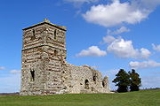
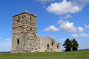
, UK. Its most recognizable features are a ruined Norman church, built within a neolithic henge monument. This site is maintained by English Heritage
English Heritage
English Heritage . is an executive non-departmental public body of the British Government sponsored by the Department for Culture, Media and Sport...
.
The henge enclosing Knowlton Church is only one of three henges and associated earthworks. However, Church Henge is the best preserved. Nearby is Great Barrow, the largest round barrow in Dorset. Aerial photographs reveal a large number of ploughed-out barrows in the immediate vicinity.
Knowlton is recorded in the Domesday Book
Domesday Book
Domesday Book , now held at The National Archives, Kew, Richmond upon Thames in South West London, is the record of the great survey of much of England and parts of Wales completed in 1086...
of 1086–87 as Chenoltone. Winfrith Newburgh
Winfrith Newburgh
Winfrith Newburgh is a village in the Purbeck district of the English county of Dorset. It is situated some eight miles west of Wareham and ten miles east of Dorchester. It was historically part of the Winfrith hundred...
, East or West Lulworth
Lulworth
Lulworth is the popular name for an area on the coast of Dorset, South West England notable for its castle and cove. However there is no actual place or feature called simply "Lulworth", the villages are East and West Lulworth and the coastal feature is Lulworth Cove.See:*East Lulworth *Lulworth...
, "Wintreborne" and Knowlton were held by King William
William I of England
William I , also known as William the Conqueror , was the first Norman King of England from Christmas 1066 until his death. He was also Duke of Normandy from 3 July 1035 until his death, under the name William II...
; they were previously held by King Edward
Edward the Confessor
Edward the Confessor also known as St. Edward the Confessor , son of Æthelred the Unready and Emma of Normandy, was one of the last Anglo-Saxon kings of England and is usually regarded as the last king of the House of Wessex, ruling from 1042 to 1066....
. The Domesday Book also records two hides
Hide (unit)
The hide was originally an amount of land sufficient to support a household, but later in Anglo-Saxon England became a unit used in assessing land for liability to "geld", or land tax. The geld would be collected at a stated rate per hide...
of the land of the Count of Mortain
Robert, Count of Mortain
Robert, Count of Mortain, 1st Earl of Cornwall was a Norman nobleman and the half-brother of William I of England. Robert was the son of Herluin de Conteville and Herleva of Falaise and was full brother to Odo of Bayeux. The exact year of Robert's birth is unknown Robert, Count of Mortain, 1st...
in Knowlton, named as Chenoltune in the book, held by Ansgar, which was held by Æthelmær in the time of King Edward
Edward the Confessor
Edward the Confessor also known as St. Edward the Confessor , son of Æthelred the Unready and Emma of Normandy, was one of the last Anglo-Saxon kings of England and is usually regarded as the last king of the House of Wessex, ruling from 1042 to 1066....
. This land paid geld, was enough for one plough with one slave and one bordar, a mill paying 12s6d, and was worth 25s.
The site of the ancient village of Knowlton (as opposed to the present day hamlet) is located 50 yards west of Knowlton Church along Lumber Lane at the banks of the River Allen. There is little to be seen on the ground, but aerial photos do show the village layout. It is believed that the village was a victim of the Black Death
Black Death
The Black Death was one of the most devastating pandemics in human history, peaking in Europe between 1348 and 1350. Of several competing theories, the dominant explanation for the Black Death is the plague theory, which attributes the outbreak to the bacterium Yersinia pestis. Thought to have...
.