
Kingsweston
Encyclopedia
Kingsweston is a ward
of the city of Bristol
. The three districts in the ward are Coombe Dingle, Lawrence Weston and Sea Mills. The ward takes its name from the old district of Kings Weston (usually spelt in two words), now generally considered part of Lawrence Weston.
emerges from a gorge passing through the Blaise Castle
Estate. A desirable area, the private housing was mainly built in the 1920s and 1930s. Further downstream is Sea Mills.
There was a tin Methodist church which was demolished in the mid-1990s. There are still some photos of it on tin Tabernacles. It was a small gothic building of the 1890s.
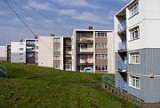
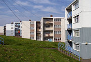 Lawrence Weston is a post war housing estate in north west Bristol
between Henbury
and Shirehampton
. It is bounded in the east by the Blaise Castle
estate and woods. It is situated directly beneath the wooded Kingsweston Hill
. The industrial complex and port of Avonmouth
is a mile or so away, across the flood plain. The residential area was built in the late 1940s/early 1950s. Originally council owned, much of the housing stock is now in private hands. It is known as "El Dub" to its inhabitants. The row of shops in Ridingleaze has been revamped and each shop is now adorned with a mural.
Lawrence Weston is well known locally for its vibrant facilities for young people. There are two youth centres, a BMX track, a young people's shop called Juicy Blitz and a Youth Inclusion project. it has the community farm and a range of clubs and groups for young people.
. The village also gave its name to Kingsweston Hill
and Kings Weston Lane, the main road between Lawrence Weston and Shirehampton.
There is a Roman villa
at Kings Weston.
 Sea Mills is a suburb of the English
port city of Bristol
. It is situated some 3.5 miles (6 km) north-west of the city centre, at the seaward end of the Avon Gorge
. Nearby suburbs are Shirehampton
, Sneyd Park
, Combe Dingle
and Stoke Bishop
.
Sea Mills was the site of a Roman
settlement, known as Portus Abonae. The name and location suggest that this was a river port, but to date there has been no archaeological proof of this. The Roman settlement seems to have been abandoned by the 4th century, and there is no evidence of Saxon
settlement.
By the Middle Ages
Bristol had become a major port, with all traffic between the port and the sea having to pass through the Avon Gorge and past Sea Mills. In 1712, Joshua Franklin, a Bristol merchant, built a wet dock
at Sea Mills, to eliminate the need for large sailing ships to navigate the dangerous River Avon any further upstream. This was located where the River Trym
enters the River Avon
. However, poor transport links doomed the enterprise and the harbour facilities fell into disrepair by the end of the 18th century. Some remains of the dock still exist, and are used as a harbour by pleasure craft.
In the 1920s and 30s, Sea Mills was developed as a planned green suburb. Much of the housing was local authority, although it is now mainly in private ownership. Adjacent to the Portway is a small estate of prefabricated bungalows dating from a post-WW2 housing scheme.
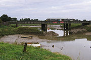
The wide A4 Portway trunk road
passes along the south-west edge of Sea Mills and links central Bristol with its outport at Avonmouth. Running parallel to the serpentine path of the River Avon, the Portway was the most expensive road in Britain when it was opened in 1926. Both the Portway and the railway line have bridges over the harbour outfall into the Avon.
Ocean-going ships used to sail past Sea Mills, going to and from Bristol City Docks. Nowadays most of the shipping is in the form of pleasure craft, Bristol's main docks now being at Avonmouth and Portbury
.
October 2006 saw the opening of The Portway Rugby Development Centre. The facilities it has are 2 outdoor 3G Crumb pitches, suitable for Rugby and Football. Outdoor grass Rugby pitches (ready for August 2007). There are 2 meeting room's and they host many aerobics classes.
. With hourly services between Bristol Temple Meads and Avonmouth railway station
, there are also peak connections to Severn Beach
.
Bus services serving the area are 40, 41, 429, 584, 585 and N7.
Wards of the United Kingdom
A ward in the United Kingdom is an electoral district at sub-national level represented by one or more councillors. It is the primary unit of British administrative and electoral geography .-England:...
of the city of Bristol
Bristol
Bristol is a city, unitary authority area and ceremonial county in South West England, with an estimated population of 433,100 for the unitary authority in 2009, and a surrounding Larger Urban Zone with an estimated 1,070,000 residents in 2007...
. The three districts in the ward are Coombe Dingle, Lawrence Weston and Sea Mills. The ward takes its name from the old district of Kings Weston (usually spelt in two words), now generally considered part of Lawrence Weston.
Coombe Dingle
Coombe Dingle is a suburb of Bristol, centred on where the River TrymRiver Trym
The River Trym is a short river, some in length, which rises in Filton, South Gloucestershire, England. The upper reaches are culverted, some underground, through mostly urban landscapes, but once it emerges into the open it flows through a nature reserve and city parks before joining the tidal...
emerges from a gorge passing through the Blaise Castle
Blaise Castle
Blaise Castle is an 18th century mansion house and estate near Henbury in Bristol , England. Blaise Castle was immortalised by being described as "the finest place in England" in Jane Austen's novel Northanger Abbey....
Estate. A desirable area, the private housing was mainly built in the 1920s and 1930s. Further downstream is Sea Mills.
There was a tin Methodist church which was demolished in the mid-1990s. There are still some photos of it on tin Tabernacles. It was a small gothic building of the 1890s.
Lawrence Weston
Bristol
Bristol is a city, unitary authority area and ceremonial county in South West England, with an estimated population of 433,100 for the unitary authority in 2009, and a surrounding Larger Urban Zone with an estimated 1,070,000 residents in 2007...
between Henbury
Henbury
Henbury is a suburb of Bristol, England, approximately 5 mi northwest of the city centre. It was formerly a village in Gloucestershire and is now bordered by Westbury-on-Trym to the south; Brentry to the east and the Blaise Castle estate Blaise Hamlet and Lawrence Weston to the west...
and Shirehampton
Shirehampton
Shirehampton, near Avonmouth, at the north-western edge of the city of Bristol, England, is a district of Bristol which originated as a separate village. It retains something of its village feel, having a short identifiable High Street with the parish church situated among shops, and is still...
. It is bounded in the east by the Blaise Castle
Blaise Castle
Blaise Castle is an 18th century mansion house and estate near Henbury in Bristol , England. Blaise Castle was immortalised by being described as "the finest place in England" in Jane Austen's novel Northanger Abbey....
estate and woods. It is situated directly beneath the wooded Kingsweston Hill
Kingsweston Hill
Kingsweston Hill is the site of an Iron Age hill fort near Henbury, Bristol, England.It is a Scheduled Ancient Monument.It is near Kings Weston House and also the site of a tower for television broadcasting....
. The industrial complex and port of Avonmouth
Avonmouth
Avonmouth is a port and suburb of Bristol, England, located on the Severn Estuary, at the mouth of the River Avon.The council ward of Avonmouth also includes Shirehampton and the western end of Lawrence Weston.- Geography :...
is a mile or so away, across the flood plain. The residential area was built in the late 1940s/early 1950s. Originally council owned, much of the housing stock is now in private hands. It is known as "El Dub" to its inhabitants. The row of shops in Ridingleaze has been revamped and each shop is now adorned with a mural.
Lawrence Weston is well known locally for its vibrant facilities for young people. There are two youth centres, a BMX track, a young people's shop called Juicy Blitz and a Youth Inclusion project. it has the community farm and a range of clubs and groups for young people.
Kings Weston
Kings Weston was originally a hamlet (or tything) in the parish of Henbury, to the west of Lawrence Weston, subsumed into Lawrence Weston when the estate was built in the 1940s. Historically it was known as the location of Kings Weston HouseKings Weston House
Kings Weston House is a historic building in Kings Weston Lane, Kingsweston, Bristol, England.It was built between 1710 and 1725 was designed by Sir John Vanbrugh for Edward Southwell on the site of an earlier Tudor house, and remodelled 1763 by Robert Mylne. A significant architectural feature is...
. The village also gave its name to Kingsweston Hill
Kingsweston Hill
Kingsweston Hill is the site of an Iron Age hill fort near Henbury, Bristol, England.It is a Scheduled Ancient Monument.It is near Kings Weston House and also the site of a tower for television broadcasting....
and Kings Weston Lane, the main road between Lawrence Weston and Shirehampton.
There is a Roman villa
Kings Weston Roman Villa
Kings Weston Roman Villa is a Roman villa near Lawrence Weston in the north west of Bristol. The villa was discovered during the construction of the Lawrence Weston housing estate in 1947. Two distinct buildings were discovered, the Eastern building was fully excavated , the other lies mostly...
at Kings Weston.
Sea Mills
England
England is a country that is part of the United Kingdom. It shares land borders with Scotland to the north and Wales to the west; the Irish Sea is to the north west, the Celtic Sea to the south west, with the North Sea to the east and the English Channel to the south separating it from continental...
port city of Bristol
Bristol
Bristol is a city, unitary authority area and ceremonial county in South West England, with an estimated population of 433,100 for the unitary authority in 2009, and a surrounding Larger Urban Zone with an estimated 1,070,000 residents in 2007...
. It is situated some 3.5 miles (6 km) north-west of the city centre, at the seaward end of the Avon Gorge
Avon Gorge
The Avon Gorge is a 1.5-mile long gorge on the River Avon in Bristol, England. The gorge runs south to north through a limestone ridge west of Bristol city centre, and about 3 miles from the mouth of the river at Avonmouth. The gorge forms the boundary between the unitary authorities of...
. Nearby suburbs are Shirehampton
Shirehampton
Shirehampton, near Avonmouth, at the north-western edge of the city of Bristol, England, is a district of Bristol which originated as a separate village. It retains something of its village feel, having a short identifiable High Street with the parish church situated among shops, and is still...
, Sneyd Park
Sneyd Park
Sneyd Park is a suburb of Bristol, England, lying on the western fringe of Clifton Down, adjacent to the Avon Gorge and the Sea Walls observation point. Home to many millionaires, Sneyd Park was originally developed in Victorian times. Many Victorian and Edwardian villas line the edge of the Downs...
, Combe Dingle
Combe Dingle
Coombe Dingle is a suburb of Bristol, England, centred near where the Hazel Brook tributary of the River Trym emerges from a limestone gorge bisecting the Blaise Castle Estate to join the main course of the Trym. Historically this area formed part of the parish of Westbury on Trym, Gloucestershire,...
and Stoke Bishop
Stoke Bishop
Stoke Bishop is a very affluent and medium-sized outer city suburb in the north-west of Bristol, located in between Westbury-on-Trym, Sneyd Park, and Sea Mills. Although relatively small, Stoke Bishop's population has increased due to substantial infilling on the Smelting Works sports ground and...
.
Sea Mills was the site of a Roman
Roman Empire
The Roman Empire was the post-Republican period of the ancient Roman civilization, characterised by an autocratic form of government and large territorial holdings in Europe and around the Mediterranean....
settlement, known as Portus Abonae. The name and location suggest that this was a river port, but to date there has been no archaeological proof of this. The Roman settlement seems to have been abandoned by the 4th century, and there is no evidence of Saxon
Anglo-Saxons
Anglo-Saxon is a term used by historians to designate the Germanic tribes who invaded and settled the south and east of Great Britain beginning in the early 5th century AD, and the period from their creation of the English nation to the Norman conquest. The Anglo-Saxon Era denotes the period of...
settlement.
By the Middle Ages
Middle Ages
The Middle Ages is a periodization of European history from the 5th century to the 15th century. The Middle Ages follows the fall of the Western Roman Empire in 476 and precedes the Early Modern Era. It is the middle period of a three-period division of Western history: Classic, Medieval and Modern...
Bristol had become a major port, with all traffic between the port and the sea having to pass through the Avon Gorge and past Sea Mills. In 1712, Joshua Franklin, a Bristol merchant, built a wet dock
Wet dock
A wet dock is a dock where the level of water in the dock is maintained despite the raising and lowering of the tide. This makes transfer of cargo easier. It works like a lock which controls the water level and allows passage of ships.-External links:...
at Sea Mills, to eliminate the need for large sailing ships to navigate the dangerous River Avon any further upstream. This was located where the River Trym
River Trym
The River Trym is a short river, some in length, which rises in Filton, South Gloucestershire, England. The upper reaches are culverted, some underground, through mostly urban landscapes, but once it emerges into the open it flows through a nature reserve and city parks before joining the tidal...
enters the River Avon
River Avon, Bristol
The River Avon is an English river in the south west of the country. To distinguish it from a number of other River Avons in Britain, this river is often also known as the Lower Avon or Bristol Avon...
. However, poor transport links doomed the enterprise and the harbour facilities fell into disrepair by the end of the 18th century. Some remains of the dock still exist, and are used as a harbour by pleasure craft.
In the 1920s and 30s, Sea Mills was developed as a planned green suburb. Much of the housing was local authority, although it is now mainly in private ownership. Adjacent to the Portway is a small estate of prefabricated bungalows dating from a post-WW2 housing scheme.
The wide A4 Portway trunk road
Portway, Bristol
The Portway is a trunk road, approximately long, which links central Bristol, England, with its port at Avonmouth. It is part of the A4 road, which was the primary east west highway in Southern England before the construction of the M4 motorway....
passes along the south-west edge of Sea Mills and links central Bristol with its outport at Avonmouth. Running parallel to the serpentine path of the River Avon, the Portway was the most expensive road in Britain when it was opened in 1926. Both the Portway and the railway line have bridges over the harbour outfall into the Avon.
Ocean-going ships used to sail past Sea Mills, going to and from Bristol City Docks. Nowadays most of the shipping is in the form of pleasure craft, Bristol's main docks now being at Avonmouth and Portbury
Portbury
Portbury is a village and civil parish in Somerset, England within the Unitary Authority of North Somerset.The parish includes the hamlet of Sheepway which is situated on the moorland at the northern edge of the Gordano valley, between the Gordano services on the M5 motorway and Portishead, near...
.
October 2006 saw the opening of The Portway Rugby Development Centre. The facilities it has are 2 outdoor 3G Crumb pitches, suitable for Rugby and Football. Outdoor grass Rugby pitches (ready for August 2007). There are 2 meeting room's and they host many aerobics classes.
Population
According to the 2001 Census there are 10,844 people living in Kingsweston ward, over 95% of whom were white, and only 4 of whom were Jewish.http://www.bristol.gov.uk/WardFinder/pdfs/kingsweston-wis.pdfTransport
Kingsweston ward has 1 railway station, at Sea MillsSea Mills railway station
Sea Mills railway station serves the Sea Mills area of Bristol, England. The station is located near to the River Avon. This station is north-west from Bristol Temple Meads on the Severn Beach Line...
. With hourly services between Bristol Temple Meads and Avonmouth railway station
Avonmouth railway station
Avonmouth railway station is a railway station serving the suburb of Avonmouth in Bristol, north-west from Bristol Temple Meads on the Severn Beach Line. All trains serving it are operated and the station is managed by First Great Western. The station is managed by First Great Western.Five...
, there are also peak connections to Severn Beach
Severn Beach
Severn Beach is a village on the mouth of the river Severn in South Gloucestershire, England. A riverside footpath, which is part of the Severn Way, leads beneath the Second Severn Crossing bridge...
.
Bus services serving the area are 40, 41, 429, 584, 585 and N7.