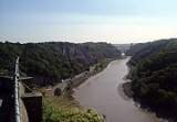
All Topics  
Avon Gorge


Avon Gorge


For the gorge in Scotland with the same name, see Avon Gorge, FalkirkAvon Gorge, Falkirk

The Avon Gorge, Falkirk is a small wooded gorge in Falkirk, Scotland....


The Avon Gorge () is a 1.5 mile (2.5 km) long gorge on the River AvonRiver Avon, Bristol

The River Avon is a river in the south west of England....
 in BristolBristol

Bristol is a city, unitary authority and ceremonial county in South West England, 115 miles west of London and located at ...
, EnglandEngland

England is the largest and most populous constituent country of the United Kingdom....
. The gorge runs south to north through a limestoneLimestone

Limestone is a sedimentary rock composed largely of the mineral calcite ....
 ridge west of Bristol city centre, and about 3 miles (5 km) from the mouth of the riverRiver

A river is a large natural waterway....
 at AvonmouthAvonmouth

style="margin-left: inherit; font-size: large;" |Avonmouth...
. The gorge forms the boundary between the unitary authoritiesUnitary authority

A unitary authority is a type of local authority that has a single tier and is responsible for all local government function...
 of North SomersetNorth Somerset

North Somerset is a unitary authority in England....
 and Bristol. In the past, when Bristol was an important portPort

A port is a facility for receiving ships and transferring cargo to and from them....
, the gorge formed a spectacular defensive gateway to the city.

On the east of the gorge is the town of CliftonClifton, Bristol Summary

Clifton is an inner suburb of the English port city of Bristol....
, part of Bristol city, and The DownsThe Downs (Bristol)

The Downs are an area of public open limestone downland in Bristol, England....
, a large public park. To the west of the gorge is Leigh WoodsLeigh Woods

Leigh Woods is an area of woodland on the south-west side of the Avon Gorge, opposite the English city of Bristol and north ...
, the name of both a village and the National TrustNational Trust for Places of Historic Interest or Natural Beauty

The National Trust for Places of Historic Interest or Natural Beauty, usually known as The National Trust, is a conser...
 forestForest

A forest is an area with a high density of trees ....
 it is situated in. There are three Iron AgeIron Age

In archaeology, the Iron Age is the stage in the development of any people where the use of iron implements as tools and wea...
 hill fortHill fort

Hill forts in Scotland]]* see ...
s overlooking the gorge, as well as a more recent observatoryObservatory, Bristol

The Observatory is a former mill, now used as an observatory, located on Clifton Down, close to the Clifton Suspension Bridg...
. The Clifton Suspension BridgeClifton Suspension Bridge

The Clifton Suspension Bridge is a suspension bridge, spanning the Avon Gorge and linking Clifton in Bristol to Leigh Woods ...
, an icon of Bristol, crosses the gorge.

Geology and formation


The gorge cuts through a ridge mainly of limestoneLimestone

Limestone is a sedimentary rock composed largely of the mineral calcite ....
, with some sandstoneFacts About Sandstone

Sandstone is a sedimentary rock composed mainly of sand-size mineral or rock grains....
. This particular ridge runs from Clifton to ClevedonClevedon

Clevedon is a town in North Somerset, England....
, 10 miles (16 km) away on the Bristol ChannelBristol Channel

The Bristol Channel is a major inlet in the island of Great Britain, separating South Wales from South West England and exte...
 coast, though limestone is found throughout the Bristol area. The fossilFossil

Fossils are the mineralized or otherwise preserved remains or traces of animals, plants, and other organisms....
 shells and corals indicate that the limestone formed in shallow tropical seas in the CarboniferousCarboniferous

The Carboniferous is a major division of the geologic timescale that extends from the end of the Devonian period, about 359....
, 350 million years ago. For a long time it was unclear what caused the Avon to cut through the limestone ridge, rather than run south west through the Ashton Vale towards Weston-super-MareWeston-super-Mare

Weston-super-Mare is an English seaside resort town in North Somerset, population 71,758....
. However, Bristol was at the southern edge of glaciationGlacier

A glacier is a large, long-lasting river of ice that is formed on land and moves in response to gravity....
 during the last ice ageIce age

An ice age is a period of long-term downturn in the temperature of Earth's climate, resulting in an expansion of the contine...
, and it has been suggested that ice blocked the river's natural route through Ashton Vale to the west.

At various times the sides of the gorge have been quarried, leaving steep gorge walls. In the 18th century the gorge was quarried to produce building stone for the city. Stone was taken by boat into the floating harbour. In the 19th century celestine was discovered in Leigh CourtLeigh Court

Leigh Court is a Grade II* listed building in Abbots Leigh, Somerset, England....
 estate (see Paradise Bottom), and the Miles family authorised quarrying. Between 1880 and 1920 Bristol was producing 90% of the world's celestine, but the enterprise did not last long into the 20th century. Quarries on the Bristol side of the gorge are now popular with climbers and are a habitatHabitat (ecology)

Habitat is the place where a particular species lives and grows....
 for Peregrine falconPeregrine Falcon

The Peregrine Falcon, sometimes formerly known in North America as Duck Hawk, is a medium-sized falcon about the size ...
s and other wildlife.

Ecology


The steep walls of the gorge support some rare fauna and flora, including species unique to the gorge. There are a total of 24 rare plant species and two unique trees: the Bristol and Wilmotts's whitebeamFacts About Whitebeam

The whitebeams are members of the Rosaceae family, in genus Sorbus subgenus Aria....
s. Other notable plants include Bristol rock cress, Bristol onion, Spiked SpeedwellSpiked Speedwell

Veronica spicata is a species of the genus Veronica....
, Autumn Squill and Honewort. Because of its steep sides, there are many parts of the gorge on which trees cannot grow, making way for smaller plants. The gorge is also home to many rare invertebrateInvertebrate

Invertebrate is a term coined by Jean-Baptiste Lamarck to describe any animal without a spinal column....
 species. The gorge has a unique microclimateMicroclimate

A microclimate is a local external atmospheric zone where the climate differs from the surrounding area....
, around 1 degree warmer than the surrounding land. The steep south-west facing sides receive the afternoon sunlight, but are partially sheltered from the prevailing winds. When winds come from the Bristol Channel in the north west they may be funnelled into the gorge, creating harsh and wet conditions.

The steep gorge walls make an ideal habitat for peregrine falconPeregrine Falcon

The Peregrine Falcon, sometimes formerly known in North America as Duck Hawk, is a medium-sized falcon about the size ...
s, with a plentiful supply of food nearby in the form of pigeons and sea gulls. Peregrines have a history of nesting in the gorge, but having become rare in the British Isles they did not breed and were rarely seen in the gorge after the 1930s. In 1990 Peregrines returned to the gorge, and have successfully bred in most of the following years. On warm days a strong uplift forms in the gorge, on which birds of prey soar while hunting. The gorge also houses large populations of JackdawJackdaw

The Jackdaw is one of the smallest species in the genus of crows and ravens. ...
 and horseshoe bats, both of which find homes in the caves and bridge buttresses.

Due to its geology and ecology, an area of of the gorge and surrounding woodland has been protected as a biological and geological Site of Special Scientific Interest (SSSI), the original notification taking place in 1952. The site may in future be protected as a Special Area of Conservation under the European Habitats Directive. The Leigh Woods side of the gorge is largely owned by the National Trust. The DownsThe Downs (Bristol)

The Downs are an area of public open limestone downland in Bristol, England....
 on the city side of the gorge are owned by Bristol City Council and managed as a large public park. The actual gorge side is protected in partnership with Bristol ZooBristol Zoo Overview

Bristol Zoo is a major UK tourist attraction in the city of Bristol in Southwest England....
, WWFWorld Wide Fund for Nature

WWF World Wide Fund for Nature is a global environment conservation, research, environmental advocacy and restoratio...
 and English NatureEnglish Nature

English Nature is the United Kingdom government agency that promotes the conservation of wildlife, geology and wild places ...
. The council's management of the gorge involves balancing the need to protect its ecology with recreational uses such as rock climbing.

History of human use


The gorge area was inhabited at least as early as the Iron AgeIron Age

In archaeology, the Iron Age is the stage in the development of any people where the use of iron implements as tools and wea...
, probably by the DobunniDobunni

The Dobunni were one of the Celtic tribes living in the British Islands prior to the Roman invasion of Britain....
 tribe. In Leigh Woods above Nightingale Valley, a steep dry valley beside the suspension bridge, is Stokeleigh Camp, one of three Iron Age hill forts in the area. Stokeleigh was occupied from 3BCE to 1CE, and was also used in the Middle Ages. The camp was protected on two sides by the cliff faces of the gorge and Nightingale Valley, and was also protected by earthworks, and is now a scheduled ancient monumentScheduled Ancient Monument Summary

In the United Kingdom, a Scheduled Ancient Monument is a protected archaeological site or historic building considered to be...
. A second hill fort was situated across Nightingale Valley, but has since been built on, and bridge road cuts through it. The third hill fort was situated on the opposite side of the gorge, in what is now observatory green. Archaeology, plus the configuration of the three forts, suggest they played a role in defending the gorge.


During the Middle AgesMiddle Ages

The Middle Ages formed the middle period in a traditional schematic division of European history into three "ages": the clas...
 and industrial revolutionIndustrial Revolution

The Industrial Revolution was the major technological, socioeconomic and cultural change in the late 18th and early 19th cen...
 the area which now forms The Downs was used as common grazing land. It was mined for leadLead

Lead is a chemical element in the periodic table that has the symbol Pb and atomic number 82....
, calamineCalamine (mineral)

Calamine is a historic name for an ore of zinc....
, ironIron

Iron is a chemical element with the symbol Fe and atomic number 26....
 and limestone, and became home to a windmillWindmill

A windmill is an engine powered by the wind to produce energy, often contained in a large building as in traditional post mi...
 which produced snuffTobacco Overview

Tobacco refers to a genus of broad-leafed plants of the nightshade family indigenous to North and South America, or to the ...
 from the tobacco which had become one of the city's principal imports. In 1777 the windmill bunt out in a storm, and the building was converted into the observatoryObservatory, Bristol

The Observatory is a former mill, now used as an observatory, located on Clifton Down, close to the Clifton Suspension Bridg...
, which houses a camera obscuraCamera obscura

The camera obscura was an optical device used in drawing, and one of the ancestral threads leading to the invention of phot...
. In the 18th and 19th centuries Bristol's economy boomed and Clifton became a desirable place to live. Mansion houses were built over looking the gorge, but after grazing was stopped, trees grew and obscured the view from these mansions. In the Victorian era, with houses creeping further onto the Downs, an Act of ParliamentAct of Parliament

An Act of Parliament or Act is law enacted by the parliament....
 was passed to protect them as a park for the people of Bristol. In 1754 a bridge to span the gorge was proposed, but it was nearly 80 years before work began on Isambard Kingdom BrunelIsambard Kingdom Brunel

Isambard Kingdom Brunel, FRS, was an English engineer....
's Clifton Suspension BridgeClifton Suspension Bridge

The Clifton Suspension Bridge is a suspension bridge, spanning the Avon Gorge and linking Clifton in Bristol to Leigh Woods ...
, and a further 30 years of delays before it was completed. Today the bridge is perhaps the best known landmarkLandmark

Originally, a landmark literally meant a geographic feature used by explorers and others to find their way back or through a...
 in Bristol.

Throughout Bristol's history the gorge has been an important transport route. It is the gateway to Bristol HarbourBristol Harbour

Bristol Harbour is the harbour in the city of Bristol, England....
, and provided protection against storms or attack. The Bristol Channel and Avon estuary have a very high tidal range, and the gorge is relatively narrow and meandering, making it notoriously difficult to navigate and giving rise to the phrase ship shape and Bristol fashionShipshape and Bristol fashion

Shipshape and Bristol fashion is an English saying....
.

Today Bristol Harbour is no longer an important port, but the gorge is still a transport route. The A4 roadA4 road

The A4 is a major road in England, portions of which are known as the Great West Road and Bath Road....
 runs through the gorge, linking Bristol city centre to the M5 motorwayM5 motorway

The M5 is a motorway in England. It runs from the M6 near Wednesbury to Exeter in Devon....
, which bypasses the city near AvonmouthAvonmouth

style="margin-left: inherit; font-size: large;" |Avonmouth...
. Two railways run through the gorge, on the east side the passenger railway to Avonmouth and Severn BeachSevern Beach

Severn Beach is a village on the mouth of the river Severn in South Gloucestershire, England....
 runs through part of the gorge, and through a tunnel under the Downs, while on the west side is the former Portishead RailwayPortishead Railway

The Portishead Railway was a railway which ran from Portishead to the Great Western Main Line in Bristol, England....
, which was closed by the Beeching AxeBeeching Axe

The Beeching Axe is an informal name for the British Government's attempt in the 1960s to control the spiralling cost of run...
 in the 1960s, but has now been reopened for freight traffic as far as Royal Portbury DockRoyal Portbury Dock

The Royal Portbury Dock is part of the Port of Bristol, in England....
, 2.5 miles (4 km) downstream. Between 1893 and 1934, the Clifton Rocks RailwayClifton Rocks Railway

The Clifton Rocks Railway was an underground funicular railway in Bristol, linking Clifton at the top to Hotwells at the bot...
 linked the passenger steamer pier at HotwellsHotwells

Hotwells is a district of the English port city of Bristol....
 with CliftonClifton, Bristol

Clifton is an inner suburb of the English port city of Bristol....
 on the rim of the gorge.

A footpath and National Cycle NetworkNational Cycle Network

The National Cycle Network is a network of cycle routes in the United Kingdom....
 cycleway run alongside the Portishead Railway and along the old towpath.

Mythology

The formation of the Avon Gorge is the subject of mediaeval mythology. The myths tell tales of two giant brothers, Goram and VincentGoram and Vincent

Goram and Vincent are legendary giants in the folklore of the Bristol area, UK....
, who constructed the gorge. One variation holds that Vincent and Goram were constructing the gorge together and Goram fell asleep, to be accidentally killed by Vincent's pickaxe. Another variation tells of the brothers falling for Avona, a girl from WiltshireWiltshire

Wiltshire is a large southern English county....
, who instructs the giants to drain a lake which stretches from Rownham Hill to Bradford-on-Avon (i.e. the Avon valley). Goram began digging the nearby Hazel Brook Gorge in Blaise CastleBlaise Castle

Blaise Castle is an 18th century mansion house and estate near Henbury in Bristol, England....
 estate, but consumed too much beer and fell asleep. Vincent dug the Avon Gorge and drained the lake, winning the affection of Avona. Upon waking Goram stamped his foot, creating "The Giant's Footprint" in the Blaise Castle estate, and threw himself into the Bristol Channel, turning to stone and leaving head and shoulder above water as the islands Flat HolmFlat Holm Overview

Flat Holm is a Welsh island lying in the Bristol Channel approximately 3.5 miles from Lavernock Point in South Wales....
 and Steep HolmSteep Holm

Steep Holm is a 48.87 acre at high tide, expanding to 63.26 acres at mean low water, 25.51 hectare, English island lying in ...
.

External links