

Khortytsia
Encyclopedia
Khortytsia is a national cultural reserve (sanctuary) located on one of the largest islands of the Dnieper river, in Ukraine
.
The island has played an important role in the history of Ukraine
, specially in the history of the Zaporozhian Cossacks. This historic site is located within the city limits of Zaporizhia
city. It extends from northwest to southeast for more than 12 km (7.5 mi) with an average width around 2.5 km (1.6 mi). The island has unique flora and fauna, including oak groves, spruce woods, meadows, and steppe
. The northern part of the island is very rocky and high (rising 30 m (98.4 ft) above the river bed) in comparison to the southern part, which is low, and often flooded by the waters of the Dnieper.
(direct translation is "beyond the rapids") takes its name from an area downstream of the Dnieper river after the nine rapids. In 1930s when the Dnieper Hydroelectric Station
was built, these rapids were flooded. Only granite
cliffs, rising to the height of 50 m (164 ft), testify to the original rocky terrain of the region.
Khortytsia has been continuously inhabited during the last five millennia. Other islands in the immediate vicinity also contain indications of intensive occupation during the Proto-Indo-European
and Scythian periods. The island of Small Khortytsia is known for its Scythian remains and a derelict Cossack fortress. The islet of Sredeny Stih (to the northeast of Khortytsia), excavated during construction of the hydroelectric station in 1927, gave its name to the Seredny Stih culture
.
In the Early Middle Ages
, Khortytsia was a key centre for the trade route from the Varangians to the Greeks
. In his treatise De Administrando Imperio
, Emperor Constantine VII
mentions the island of St. George immediately downstream from the rapids. He reports that, while passing through the rapids, the Rus would be easy prey for the nomadic Pechenegs. Indeed, the Kiev Rus' prince Svyatoslav I was attacked and killed during his attempt to cross the rapids in 972.
The very first stronghold known as a Sich was located on the island of Small Khortytsia (Mala Khortytsia Island) and was established by the Volhynian prince Dmytro Vyshnevetsky
. The Small Khortytsia Island is 20 times smaller than Khortytsia itself. The first Khortytsia Sich existed six years (1552–1558). There are few others locations downstream past the rapids (Zaporizhia area) where the Zaporizhian Sich was located. There are eight of them: Bazavluk (1593–1630), Mykytyn (1628–1652), Chortomlyk (1652–1709), Kamin (1709–1711), Oleshkiv (1711–1734), Pidpilna (1734–1775). All these places were at river crossings. The uprising led by Bohdan Khmelnytsky
was started at the Mykytyn Sich in 1648. Legends state, that cossacks wrote the notorious Reply of the Zaporozhian Cossacks to Sultan Mehmed IV of the Ottoman Empire
on Khortytsia. In the 1775, the Sich was destroyed by the Russian general Tekhely on the order of Catherine the Great
. The Zaporozhian Cossacks as a result were displaced, many eventually settling on the Kuban
river in the Caucasus area. These Cossacks became known as Kuban cossacks. A part of the Zaporozhian Cossacks escaped to beyond the Danube to become vassals of the Ottoman Sultan. They dwelt at mouth of the Danube river. In 1830 many of these Cossacks moved and established a new Sich on the Azov sea shore (between Mariupol
and Berdiansk
).
The last Kosh Otaman (leader) of Zaporizhian Sich Petro Kalnyshevsky
was imprisoned at Solovetsky Island
Monastery. At that time he was 85 years old. After 25 years in prison he was released and died almost blind at the monastery at age of 113 years.
In 1789, Danzig Mennonites from Prussia
were invited by the czar to form settlements on the vast steppes of the Russian Empire
. One of these settlements was located on the island of Khortytsia. They farmed on the rich island soil. Some of their profitable business was trade in lumber from the Khortytsia groves and woods. In 1916 the German colonists sold Khortytsia Island to the Olexandrivsk
(Alexandrovsk) city council (see Chortitza Colony). It was a declared a national sanctuary.
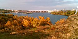 The major part of the sanctuary covers the Zaporizhian Cossack Museum that includes the Cossack horse show. The museum building is modern, nestling low in the landscape with dramatic views of the Dnieper Hydroelectric Station
to the north. The museum was built on October 14, 1983 as the Museum of Zaporizhia History although its project was approved by the Ministry of Culture and Derzhbud of Ukraine in December 1970. The expo area of the museum was accounted for 1600 m² (17,222.3 sq ft) portraying following themes: Khortytsia in ancient times, history of Zaporizhian Cossacks, history of Zaporizhia at times of construction of socialism. There also existed four diorama
s: "Battle of Sviatoslav at rapids" (author - M.Ovyechkin), "Uprising of the impoverished cossacks at Zaporizhian Sich in 1768" (M.Ovyechkin), "Construction of Dnieper HES" (V.Trotsenko), "Night storm of Zaporizhia city in October 1943" (M.Ovyechkin). Part of the museum became also the Zaporizhian Oak located at the Upper Khortytsia. In 1992 the exposition of the museum was redesigned.
The museum contains exhibits dating from the Stone Age through the Scythian period (c.750 - 250 BC) down to the 20th century.
, which is a part of a 150 kV powerline crossing Dnieper river. http://novoklimov.io.ua/album195039
Ukraine
Ukraine is a country in Eastern Europe. It has an area of 603,628 km², making it the second largest contiguous country on the European continent, after Russia...
.
The island has played an important role in the history of Ukraine
Ukraine
Ukraine is a country in Eastern Europe. It has an area of 603,628 km², making it the second largest contiguous country on the European continent, after Russia...
, specially in the history of the Zaporozhian Cossacks. This historic site is located within the city limits of Zaporizhia
Zaporizhia
Zaporizhia or Zaporozhye [formerly Alexandrovsk ] is a city in southeastern Ukraine, situated on the banks of the Dnieper River. It is the administrative center of the Zaporizhia Oblast...
city. It extends from northwest to southeast for more than 12 km (7.5 mi) with an average width around 2.5 km (1.6 mi). The island has unique flora and fauna, including oak groves, spruce woods, meadows, and steppe
Steppe
In physical geography, steppe is an ecoregion, in the montane grasslands and shrublands and temperate grasslands, savannas, and shrublands biomes, characterized by grassland plains without trees apart from those near rivers and lakes...
. The northern part of the island is very rocky and high (rising 30 m (98.4 ft) above the river bed) in comparison to the southern part, which is low, and often flooded by the waters of the Dnieper.
History
ZaporizhiaZaporizhia
Zaporizhia or Zaporozhye [formerly Alexandrovsk ] is a city in southeastern Ukraine, situated on the banks of the Dnieper River. It is the administrative center of the Zaporizhia Oblast...
(direct translation is "beyond the rapids") takes its name from an area downstream of the Dnieper river after the nine rapids. In 1930s when the Dnieper Hydroelectric Station
Dnieper Hydroelectric Station
The Dnieper Hydroelectric Station is the largest hydroelectric power station on the Dnieper River, placed in Zaporizhia, Ukraine.- Early Plans :In the lower current of the Dnieper River there were almost 100 km long part of the river filled with rapids...
was built, these rapids were flooded. Only granite
Granite
Granite is a common and widely occurring type of intrusive, felsic, igneous rock. Granite usually has a medium- to coarse-grained texture. Occasionally some individual crystals are larger than the groundmass, in which case the texture is known as porphyritic. A granitic rock with a porphyritic...
cliffs, rising to the height of 50 m (164 ft), testify to the original rocky terrain of the region.
Khortytsia has been continuously inhabited during the last five millennia. Other islands in the immediate vicinity also contain indications of intensive occupation during the Proto-Indo-European
Proto-Indo-Europeans
The Proto-Indo-Europeans were the speakers of the Proto-Indo-European language , a reconstructed prehistoric language of Eurasia.Knowledge of them comes chiefly from the linguistic reconstruction, along with material evidence from archaeology and archaeogenetics...
and Scythian periods. The island of Small Khortytsia is known for its Scythian remains and a derelict Cossack fortress. The islet of Sredeny Stih (to the northeast of Khortytsia), excavated during construction of the hydroelectric station in 1927, gave its name to the Seredny Stih culture
Sredny Stog culture
The Sredny Stog culture dates from the 4500-3500 BC. It was situated just north of the Sea of Azov between the Dnieper and the Don...
.
In the Early Middle Ages
Early Middle Ages
The Early Middle Ages was the period of European history lasting from the 5th century to approximately 1000. The Early Middle Ages followed the decline of the Western Roman Empire and preceded the High Middle Ages...
, Khortytsia was a key centre for the trade route from the Varangians to the Greeks
Trade route from the Varangians to the Greeks
The trade route from the Varangians to the Greeks was a trade route that connected Scandinavia, Kievan Rus' and the Byzantine Empire. The route allowed traders along the route to establish a direct prosperous trade with Byzantium, and prompted some of them to settle in the territories of...
. In his treatise De Administrando Imperio
De Administrando Imperio
De Administrando Imperio is the Latin title of a Greek work written by the 10th-century Eastern Roman Emperor Constantine VII. The Greek title of the work is...
, Emperor Constantine VII
Constantine VII
Constantine VII Porphyrogennetos or Porphyrogenitus, "the Purple-born" was the fourth Emperor of the Macedonian dynasty of the Byzantine Empire, reigning from 913 to 959...
mentions the island of St. George immediately downstream from the rapids. He reports that, while passing through the rapids, the Rus would be easy prey for the nomadic Pechenegs. Indeed, the Kiev Rus' prince Svyatoslav I was attacked and killed during his attempt to cross the rapids in 972.
The very first stronghold known as a Sich was located on the island of Small Khortytsia (Mala Khortytsia Island) and was established by the Volhynian prince Dmytro Vyshnevetsky
Dmytro Vyshnevetsky
Dmytro Ivanovych Vyshnevetsky was a Hetman of the Ukrainian Cossacks. He was also known as Baida in the Ukrainian folk songs.-Biography:...
. The Small Khortytsia Island is 20 times smaller than Khortytsia itself. The first Khortytsia Sich existed six years (1552–1558). There are few others locations downstream past the rapids (Zaporizhia area) where the Zaporizhian Sich was located. There are eight of them: Bazavluk (1593–1630), Mykytyn (1628–1652), Chortomlyk (1652–1709), Kamin (1709–1711), Oleshkiv (1711–1734), Pidpilna (1734–1775). All these places were at river crossings. The uprising led by Bohdan Khmelnytsky
Bohdan Khmelnytsky
Bohdan Zynoviy Mykhailovych Khmelnytsky was a hetman of the Zaporozhian Cossack Hetmanate of Polish–Lithuanian Commonwealth . He led an uprising against the Commonwealth and its magnates which resulted in the creation of a Cossack state...
was started at the Mykytyn Sich in 1648. Legends state, that cossacks wrote the notorious Reply of the Zaporozhian Cossacks to Sultan Mehmed IV of the Ottoman Empire
Reply of the Zaporozhian Cossacks
Reply of the Zaporozhian Cossacks to Sultan Mehmed IV of the Ottoman Empire, also known as Cossacks of Saporog Are Drafting a Manifesto , is a painting by Russian artist Ilya Repin. The 2.03 m by 3.58 m canvas was started in 1880 and finished in 1891. Repin recorded the years of work along the...
on Khortytsia. In the 1775, the Sich was destroyed by the Russian general Tekhely on the order of Catherine the Great
Catherine II of Russia
Catherine II, also known as Catherine the Great , Empress of Russia, was born in Stettin, Pomerania, Prussia on as Sophie Friederike Auguste von Anhalt-Zerbst-Dornburg...
. The Zaporozhian Cossacks as a result were displaced, many eventually settling on the Kuban
Kuban
Kuban is a geographic region of Southern Russia surrounding the Kuban River, on the Black Sea between the Don Steppe, Volga Delta and the Caucasus...
river in the Caucasus area. These Cossacks became known as Kuban cossacks. A part of the Zaporozhian Cossacks escaped to beyond the Danube to become vassals of the Ottoman Sultan. They dwelt at mouth of the Danube river. In 1830 many of these Cossacks moved and established a new Sich on the Azov sea shore (between Mariupol
Mariupol
Mariupol , formerly known as Zhdanov , is a port city in southeastern Ukraine. It is located on the coast of the Azov Sea, at the mouth of the Kalmius River. Mariupol is the largest city in Priazovye - a geographical region around Azov Sea, divided by Russia and Ukraine - and is also a popular sea...
and Berdiansk
Berdiansk
Berdyansk is a port city in the Zaporizhia Oblast of south-east Ukraine. Serving as the administrative center of the Berdyansky Raion , the city itself is directly subordinate to the oblast, and is located on the northern coast of the Sea of Azov.The current estimated population is around 125,000...
).
The last Kosh Otaman (leader) of Zaporizhian Sich Petro Kalnyshevsky
Petro Kalnyshevsky
Kalnyshevsky Petro was the last Koshovyi Otaman of the Zaporozhian Host, serving in 1762 and from 1765 to 1775. Kalnyshevsky was the Hero in the Russo-Turkish war of 1768-1774 and was honoured with a gold medal with brilliants for courage.Being the leader of the Zaporozhian Host, Kalnyshevsky...
was imprisoned at Solovetsky Island
Solovetsky Monastery
Solovetsky Monastery was the greatest citadel of Christianity in the Russian North before being turned into a special Soviet prison and labor camp , which served as a prototype for the GULag system. Situated on the Solovetsky Islands in the White Sea, the monastery braved many changes of fortune...
Monastery. At that time he was 85 years old. After 25 years in prison he was released and died almost blind at the monastery at age of 113 years.
In 1789, Danzig Mennonites from Prussia
Prussia
Prussia was a German kingdom and historic state originating out of the Duchy of Prussia and the Margraviate of Brandenburg. For centuries, the House of Hohenzollern ruled Prussia, successfully expanding its size by way of an unusually well-organized and effective army. Prussia shaped the history...
were invited by the czar to form settlements on the vast steppes of the Russian Empire
Russian Empire
The Russian Empire was a state that existed from 1721 until the Russian Revolution of 1917. It was the successor to the Tsardom of Russia and the predecessor of the Soviet Union...
. One of these settlements was located on the island of Khortytsia. They farmed on the rich island soil. Some of their profitable business was trade in lumber from the Khortytsia groves and woods. In 1916 the German colonists sold Khortytsia Island to the Olexandrivsk
Zaporizhia
Zaporizhia or Zaporozhye [formerly Alexandrovsk ] is a city in southeastern Ukraine, situated on the banks of the Dnieper River. It is the administrative center of the Zaporizhia Oblast...
(Alexandrovsk) city council (see Chortitza Colony). It was a declared a national sanctuary.
Museum of Zaporizhian Cossacks
Dnieper Hydroelectric Station
The Dnieper Hydroelectric Station is the largest hydroelectric power station on the Dnieper River, placed in Zaporizhia, Ukraine.- Early Plans :In the lower current of the Dnieper River there were almost 100 km long part of the river filled with rapids...
to the north. The museum was built on October 14, 1983 as the Museum of Zaporizhia History although its project was approved by the Ministry of Culture and Derzhbud of Ukraine in December 1970. The expo area of the museum was accounted for 1600 m² (17,222.3 sq ft) portraying following themes: Khortytsia in ancient times, history of Zaporizhian Cossacks, history of Zaporizhia at times of construction of socialism. There also existed four diorama
Diorama
The word diorama can either refer to a nineteenth century mobile theatre device, or, in modern usage, a three-dimensional full-size or miniature model, sometimes enclosed in a glass showcase for a museum...
s: "Battle of Sviatoslav at rapids" (author - M.Ovyechkin), "Uprising of the impoverished cossacks at Zaporizhian Sich in 1768" (M.Ovyechkin), "Construction of Dnieper HES" (V.Trotsenko), "Night storm of Zaporizhia city in October 1943" (M.Ovyechkin). Part of the museum became also the Zaporizhian Oak located at the Upper Khortytsia. In 1992 the exposition of the museum was redesigned.
The museum contains exhibits dating from the Stone Age through the Scythian period (c.750 - 250 BC) down to the 20th century.
Other objects
On Khortytsia at Savutyn summit close to the same name the ravine is a 74.5m tall three electrical transmission towers, the such called Zaporizhzhia Pylon TripleZaporizhzhia Pylon Triple
The Zaporizhia Pylon Triple is a set of two triples of 74.5 metre tall electricity pylons in Zaporizhia, Ukraine. They are used for the transport of electricity generated at the Dnieper Power Station over a span of 900 metres from Khortytsia Island to the east bank of Dnieper River...
, which is a part of a 150 kV powerline crossing Dnieper river. http://novoklimov.io.ua/album195039