

Kasaragod district
Encyclopedia
Kasaragod Districtis one of the district
s of the India
n state
of Kerala
. Kasaragod District was organised as a separate district on 24 May 1984. It is the northernmost district of Kerala and is named after Kasaragod Town which is the administrative headquarters of the district.
and to the north the Dakshina Kannada
district of Karnataka
state. All along its east it is walled by the Western Ghats
while along the west the Arabian Sea
borders it. The district, covering an area of around 1992 km², has a population (2001 census
) of 1,203,342 and has two taluks, namely, Kasaragod and Hosdurg both being municipalities
as well; seventy-five villages; thirty-nine [Grama]panchayats. The district is further sub-divided into six administrative segments called development blocks, namely, Manjeshwar
, Kasaragod, Kanhangad
, and Nileshwar, Parappa, Karadukka. Like other districts of Kerala, Kasaragod district too has a high literacy rate, around 85.17%. Kasaragod district has Arabian sea
to the west and Western ghats
to the east.
In recorded history's ancient period, Kasaragod was known to the Arabs by the name Harkwillia. Many Arab travelers who visited Kerala between the 9th and the 14th centuries visited Kasaragod, which was an important trade centre then. Duarte Borbosa, the Portuguese traveler who visited Kumbla, near Kasaragod in 1514, recorded rice being exported for coir to Maldives
. Dr. Francis Buccanan, who was the family doctor of Arthur Wellesley
, visited Kasaragod in 1800. In his travelogue, he recorded information on places like Athiraparambu, Kavvai, Nileshwaram, Bekal
, Chandragiri
and Manjeshwaram
.
kingdom, while the Central and Southern parts were ruled by the Mushika
/Kolathiri
/Chirakkal
Royal Family of North Kerala
. Then, according to local legends, there were 32 Malayalam and 32 Tulu villages in this region. When the Vijayanagara empire
attacked Kasaragod, it was still under the Kolathiri
Raja
who had Nileshwaram as one of his capitals. During the decline of the Vijayanagara empire, the administration of this area was vested with Ikkery Naiks. At the onset of collapse of the Vijayanagara empire, Venkappa Naik declared independence to Ikkery. Kumbla, Chandragiri and Bekal are considered to be the chain of forts constructed or renovated by Shivappa Naik. In 1763, Hyder Ali
conquered Bedanoor (Bidnur), the capital of the Ikkery Naiks. His son Tippu Sultan conquered much of Malabar. As per the Sreerangapattanam Treaty of 1792, Tippu surrendered Malabar, except Tulunadu (Canara) to the British. The British got Tulunadu only after the death of Tippu Sultan.
The landscape is dominated by the characteristic coconut palms accompanying rolling hills and streams flowing into the sea. The landscape is dotted with tiled-roof buildings, topped with the famous Kasaragod tiles made with the local hard red clay and typically walled with laterite blocks. Older houses are commonly found with elaborate woodwork. Kasaragod district consists of two taluks viz., Kasaragod and Hosdurg (Kanhangad).
Kasaragod district has a population
of 1,302,600, roughly equal to the nation of Mauritius
or the US state of New Hampshire
. This gives it a ranking of 375th in India (out of a total of 640
). The district has a population density of 654 PD/sqkm . Its population growth rate
over the decade 2001-2011 was 8.18 %. Kasaragod has a sex ratio
of 1079 females
for every 1000 males, and a literacy rate
of 89.85 %.
The administrative language is Malayalam. Tulu
, Beary bashe
, Kannada, Hindi
, Marathi
and Konkani
are also spoken. The Malayalam spoken here has influences from Beary bashe and also from the languages of Tulu, Kannada, Konkani, Tamil and Urdu
.
 Kasaragod is one of the most beautiful districts in Kerala
state endowed with 11 rivers (out of a total of the 44 rivers that flow in Kerala), hills, beaches, backwaters, as well as temples, churches, mosques and forts.
Other tourist attractions are Chandragiri Fort, Anandashramam, Nithyanandashramam, and Kareem forest park - the only man made forest in the Kerala. The forest park is located in Parappa near Nileshwar. The Kerala State Government is planning to set up an IT park in Kasaragod. It will be constructed in 100 acre (0.404686 km²) of revenue land in Cheemeni which is estimated to generate around 50,000 IT jobs.
Kasaragod district is very rich in vegetation. Natural vegetation, except in some coastal regions, consists of different types of forests. But in spite of generally favourable climatic conditions, vegetation is not uniform. In restricted regions, with their own micro climate or special edaphic
features, plant formations assume different characters. Thus, plant communities, ranging from psammophytes and mangrove
s to evergreen forest
s are seen here.
Ranipuram Wildlife sanctaury (50 km2, proposed)
In Panathady RF, the proposed Ranipuram Wildlife sanctuary / National park of Kanhangad forest range consists of various flora and fauna which are endemic to the Western Ghats and a yet to studied biodiversity hotspot. It merges with the Talacauvery wildlife sanctuary. Ranipuram hill station
which falls in Panathady reserve forest is an ideal area to notify as a wild life sanctuary/National park. Shola
forest seen only here in this district. Elephants, leopards, deer, wild dogs, wild boars, macaques, jungle cats, Leopard cats slender loris, porcupines, malabar giant squirrels, malabar civet cat, many species of birds, rare butterflies and medicinal plants are found in these forest.
Most of these highly endangered animals are killed by people due to lack of conversational awareness or to protect their crops. Ranipuram wild life sanctuary will be in contiguous to Talacauvery wildlife sanctuary in Karnataka
. If it is declared as a wild life sanctuary, it will enhance the tourism industry of this district along with Ranipuram hill station/Biodiversity park. Declaring it as a wildlife sanctuary is the only way to protect this Westernghat biodiversity hotspot and permanent solution for Encroachment, Poaching, hunting in night, mining, Illegal tree felling which are main threats for this park.
The proposed Munnamkadavu Dam may very useful to create a fresh water and wetland ecosystem and sanctuary for wild crocodile, otter, endangered fish and water birds. Afforestation around the catchment area of dam reservoir will help to create another new wildlife sanctuary here in future and recreate lost wild elephant corridor.
Malom Wildlife Sanctuary (5 km2)
Malom reserve forest of Kanhangad range consists of Tropical rainforest and many wild animals like as rhesus monkey, wild pig, flying squirrels, slender loris, porcupine, and birds like peacock, Malabar hornbill and grey horn bill are seen. Snakes like cobras, python and king cobras reported. It is 28 km away east of Kanhangad in Balal-Kallar panchayath.
Adoor wildlife sanctuary (2 km2)
A Fragmented, Adoor reserve forest which spreads about 2 km2 in Kasaragod district is the home for endangered animals like jungle cat, slender loris, wild pig, porcupine, turtles, peacock, Malabar horn bill, butterflies, medicinal plants and wet evergreen forest. Illicit tree felling, hunting, encroachment are main threats for this sanctuary. It is about 35 km east of Kasaragod town in Adoor-Kuttikol panchayath.
Parappa wildlife sanctuary (2 km2)
A fragmented RF, Parappa reserve forest of Kanhangad range are home for jungle cats, slender loris, wild pig, porcupine, turtles, peacock, Malabar horn bill, butterflies, medicinal plants and wet evergreen forest. Illicit tree felling, hunting, encroachment are main threats for this sanctuary. It is about 22 km East of Chervathur town
Kammadam sacred grove wildlife sanctuary (50 acres)
Kammadam kavu, related with Bhagavathi temple, is the biggest sacred grove of Kerala and rich in wildlife, evergreen forest, orchids, medicinal plants and shrubs. Wild animals like Jungle cat, monitor lizard, civets, fox, bats, snakes, various species of birds and butterflies seen. It is 25 km east of Kanhangad town.
Kareem's Forest park (32 acres)
India's first private sanctuary which spreads across 32 acres (129,499.5 m²) and rich in diverse species of trees, medicinal plants, birds, insets, reptiles, amphibians, small wild animals, microorganisms and so on. People from different walks of life environmentalists, scientists, University and Ayurveda students, and laymen, all over the country visit his forest park for practical experience and study purpose. He is also multiplying and distributing the seeds and saplings of forest trees and medicinal plants and help our mother earth and help the nation to convert waste lands in to thick forests by replicating his efforts without involving additional coasts.
The park is situated at Puliyamkulam, near Parappa. It is 23 km away east of kanhangad town. Frequent bus service available.
Thalangara Children's Park
Located 4 km from Kasargod Town, Thalangara West, is located right next to the Fishing Harbour. Many water birds, spotted snakes, foxes also reported.
...BANGOD bay park
located 5 km away from kasaragod town,a beautiful park near to a mosque and madeena manzil, it is the best place for children's to enjoy and have fun in watergames etc.. this has a very wondurful garden with lovely flowers and many more funs...
The agrarian struggle to end the exploitation and oppression by landlords and chieftains were part of the National Movement. The Kadakom Sathyagraha was started following the arrest of Gandhiji in 1932. The Palayi Harvest Agitation (1941), Cheemeni Estate Struggle (1942), Kayyur Agrarian Riot (1944), Eleri Estate Agitation (1946), Karinthalam Paddy Seizure Revolt (1948) and many other struggles waged by the peasant organisations accelerated the tempo of the freedom movement. Besides the agitation of the peasants, the various struggles unleashed for the uplift of the scheduled castes and tribes also supported and enlivened the National Movement.
Districts of Kerala
The Indian state of Kerala borders with the states of Tamil Nadu on the south and east, Karnataka on the north and the Arabian Sea coastline on the west. The Western Ghats, bordering the eastern boundary of the State, form an almost continuous mountain wall, except near Palakkad where there is a...
s of the India
India
India , officially the Republic of India , is a country in South Asia. It is the seventh-largest country by geographical area, the second-most populous country with over 1.2 billion people, and the most populous democracy in the world...
n state
States and territories of India
India is a federal union of states comprising twenty-eight states and seven union territories. The states and territories are further subdivided into districts and so on.-List of states and territories:...
of Kerala
Kerala
or Keralam is an Indian state located on the Malabar coast of south-west India. It was created on 1 November 1956 by the States Reorganisation Act by combining various Malayalam speaking regions....
. Kasaragod District was organised as a separate district on 24 May 1984. It is the northernmost district of Kerala and is named after Kasaragod Town which is the administrative headquarters of the district.
Overview
To its south lies Kannur DistrictKannur district
Kannur District is one of the 14 districts in the state of Kerala, India. The town of Kannur is the district headquarters, and gives the district its name. The old name Cannanore is the anglicised form of the Malayalam name Kannur. Kannur District is bounded by Kasaragod District to the north and...
and to the north the Dakshina Kannada
Dakshina Kannada
- Geography :The district geography consists of sea shore in the west and Western Ghats in the east. The major rivers are Netravathi, Kumaradhara, Phalguni, Shambhavi, Nandini or Pavanje and Payaswini which all join Arabian sea. Vast areas of evergreen forests which once covered this district, have...
district of Karnataka
Karnataka
Karnataka , the land of the Kannadigas, is a state in South West India. It was created on 1 November 1956, with the passing of the States Reorganisation Act and this day is annually celebrated as Karnataka Rajyotsava...
state. All along its east it is walled by the Western Ghats
Western Ghats
The Western Ghats, Western Ghauts or the Sahyādri is a mountain range along the western side of India. It runs north to south along the western edge of the Deccan Plateau, and separates the plateau from a narrow coastal plain along the Arabian Sea. The Western Ghats block rainfall to the Deccan...
while along the west the Arabian Sea
Arabian Sea
The Arabian Sea is a region of the Indian Ocean bounded on the east by India, on the north by Pakistan and Iran, on the west by the Arabian Peninsula, on the south, approximately, by a line between Cape Guardafui in northeastern Somalia and Kanyakumari in India...
borders it. The district, covering an area of around 1992 km², has a population (2001 census
Census
A census is the procedure of systematically acquiring and recording information about the members of a given population. It is a regularly occurring and official count of a particular population. The term is used mostly in connection with national population and housing censuses; other common...
) of 1,203,342 and has two taluks, namely, Kasaragod and Hosdurg both being municipalities
Municipality
A municipality is essentially an urban administrative division having corporate status and usually powers of self-government. It can also be used to mean the governing body of a municipality. A municipality is a general-purpose administrative subdivision, as opposed to a special-purpose district...
as well; seventy-five villages; thirty-nine [Grama]panchayats. The district is further sub-divided into six administrative segments called development blocks, namely, Manjeshwar
Manjeshwar
Manjeshwara is the northern tip of Kerala, bordering Karnataka. It is a small coastal village in Kasaragod district in the Indian state of Kerala. It is 21 km from Mangalore town...
, Kasaragod, Kanhangad
Kanhangad
Kanhangad is a town and a municipality in Kasaragod district in the Indian state of Kerala. It is 28 km from the district headquarters of Kasaragod. Bekal Fort is a 300-year old fort, one of the largest and best preserved forts in Kerala and lies 10 km north of Kanhangad. The fort is...
, and Nileshwar, Parappa, Karadukka. Like other districts of Kerala, Kasaragod district too has a high literacy rate, around 85.17%. Kasaragod district has Arabian sea
Arabian Sea
The Arabian Sea is a region of the Indian Ocean bounded on the east by India, on the north by Pakistan and Iran, on the west by the Arabian Peninsula, on the south, approximately, by a line between Cape Guardafui in northeastern Somalia and Kanyakumari in India...
to the west and Western ghats
Western Ghats
The Western Ghats, Western Ghauts or the Sahyādri is a mountain range along the western side of India. It runs north to south along the western edge of the Deccan Plateau, and separates the plateau from a narrow coastal plain along the Arabian Sea. The Western Ghats block rainfall to the Deccan...
to the east.
In recorded history's ancient period, Kasaragod was known to the Arabs by the name Harkwillia. Many Arab travelers who visited Kerala between the 9th and the 14th centuries visited Kasaragod, which was an important trade centre then. Duarte Borbosa, the Portuguese traveler who visited Kumbla, near Kasaragod in 1514, recorded rice being exported for coir to Maldives
Maldives
The Maldives , , officially Republic of Maldives , also referred to as the Maldive Islands, is an island nation in the Indian Ocean formed by a double chain of twenty-six atolls oriented north-south off India's Lakshadweep islands, between Minicoy Island and...
. Dr. Francis Buccanan, who was the family doctor of Arthur Wellesley
Arthur Wellesley, 1st Duke of Wellington
Field Marshal Arthur Wellesley, 1st Duke of Wellington, KG, GCB, GCH, PC, FRS , was an Irish-born British soldier and statesman, and one of the leading military and political figures of the 19th century...
, visited Kasaragod in 1800. In his travelogue, he recorded information on places like Athiraparambu, Kavvai, Nileshwaram, Bekal
Bekal
-References:* *...
, Chandragiri
Chandragiri
Chandragiri , is a suburb of Tirupati in Andhra Pradesh, India. Recently it is included under Municipal Corporation limits of Tirupati...
and Manjeshwaram
Manjeshwaram
Manjeshwar is the northern tip of Kerala, bordering Karnataka. It is a small coastal village in Kasaragod district in the Indian state of Kerala. It is 21 km from Mangalore town...
.
Recorded History
The Northernmost parts of Kasaragod District were once within the territory of the TuluvaTuluva
The Tuluva -Geographic Distribution :Though most of the Tuluva population is found in the Tulu Nadu region, migrant poplulations are found the world over. In recent times, the first period of migration started at the beginning of the 20th century to places such as Mumbai and Chennai and other...
kingdom, while the Central and Southern parts were ruled by the Mushika
Mushika Kingdom
Mushika Kingdom was an ancient kingdom of the Tamil Sangam age in present day northern Kerala, India ruled by the Royal dynasty of the same name. They ruled the strip of land between Mangaluru in the north and Vadagara in the south...
/Kolathiri
Kolathiri
Kolathiri or Kolathiri Rājā was the title by which the senior most male along the matilinial line of the Mushika or Kolathunādu Royal Family was styled...
/Chirakkal
Chirakkal Raja
Chirakkal Raja is the title of the senior most king of the Chirakkal branch of the Palli division of the Kolathiri dynasty of the erstwhile feudal state of Kolathunadu in North Malabar, Kerala state, South India. Chirakkal Rajas and Kolathiris traces their ancestry back to the Mushika dynasty of...
Royal Family of North Kerala
Kerala
or Keralam is an Indian state located on the Malabar coast of south-west India. It was created on 1 November 1956 by the States Reorganisation Act by combining various Malayalam speaking regions....
. Then, according to local legends, there were 32 Malayalam and 32 Tulu villages in this region. When the Vijayanagara empire
Vijayanagara Empire
The Vijayanagara Empire , referred as the Kingdom of Bisnaga by the Portuguese, was an empire based in South Indian in the Deccan Plateau region. It was established in 1336 by Harihara I and his brother Bukka Raya I of the Yadava lineage. The empire rose to prominence as a culmination of attempts...
attacked Kasaragod, it was still under the Kolathiri
Kolathiri
Kolathiri or Kolathiri Rājā was the title by which the senior most male along the matilinial line of the Mushika or Kolathunādu Royal Family was styled...
Raja
Raja
Raja is an Indian term for a monarch, or princely ruler of the Kshatriya varna...
who had Nileshwaram as one of his capitals. During the decline of the Vijayanagara empire, the administration of this area was vested with Ikkery Naiks. At the onset of collapse of the Vijayanagara empire, Venkappa Naik declared independence to Ikkery. Kumbla, Chandragiri and Bekal are considered to be the chain of forts constructed or renovated by Shivappa Naik. In 1763, Hyder Ali
Hyder Ali
Hyder Ali was the de facto ruler of the Kingdom of Mysore in southern India. Born Hyder Naik, he distinguished himself militarily, eventually drawing the attention of Mysore's rulers...
conquered Bedanoor (Bidnur), the capital of the Ikkery Naiks. His son Tippu Sultan conquered much of Malabar. As per the Sreerangapattanam Treaty of 1792, Tippu surrendered Malabar, except Tulunadu (Canara) to the British. The British got Tulunadu only after the death of Tippu Sultan.
Geography
The district is the northern most district of state of Kerala. Kasaragod is located at 12.5°N 75.0°E. It has an average elevation of 19 metres (62 feet).The landscape is dominated by the characteristic coconut palms accompanying rolling hills and streams flowing into the sea. The landscape is dotted with tiled-roof buildings, topped with the famous Kasaragod tiles made with the local hard red clay and typically walled with laterite blocks. Older houses are commonly found with elaborate woodwork. Kasaragod district consists of two taluks viz., Kasaragod and Hosdurg (Kanhangad).
Demographics
According to the 2011 census2011 census of India
The 15th Indian National census was conducted in two phases, houselisting and population enumeration. Houselisting phase began on April 1, 2010 and involved collection of information about all buildings...
Kasaragod district has a population
Demographics of India
The demographics of India are inclusive of the second most populous country in the world, with over 1.21 billion people , more than a sixth of the world's population. Already containing 17.5% of the world's population, India is projected to be the world's most populous country by 2025, surpassing...
of 1,302,600, roughly equal to the nation of Mauritius
Mauritius
Mauritius , officially the Republic of Mauritius is an island nation off the southeast coast of the African continent in the southwest Indian Ocean, about east of Madagascar...
or the US state of New Hampshire
New Hampshire
New Hampshire is a state in the New England region of the northeastern United States of America. The state was named after the southern English county of Hampshire. It is bordered by Massachusetts to the south, Vermont to the west, Maine and the Atlantic Ocean to the east, and the Canadian...
. This gives it a ranking of 375th in India (out of a total of 640
Districts of India
A district is an administrative division of an Indian state or territory. Districts are further subdivided, in some cases into Sub-Divisions, and otherwise directly into tehsils or talukas.District officials include:...
). The district has a population density of 654 PD/sqkm . Its population growth rate
Family planning in India
Family planning in India is based on efforts largely sponsored by the Indian government. In the 1965-2009 period, contraceptive usage has more than tripled and the fertility rate has more than halved , but the national fertility rate is still high enough to cause long-term population growth...
over the decade 2001-2011 was 8.18 %. Kasaragod has a sex ratio
Sex ratio
Sex ratio is the ratio of males to females in a population. The primary sex ratio is the ratio at the time of conception, secondary sex ratio is the ratio at time of birth, and tertiary sex ratio is the ratio of mature organisms....
of 1079 females
Women in India
The status of women in India has been subject to many great changes over the past few millennia. From equal status with men in ancient times through the low points of the medieval period, to the promotion of equal rights by many reformers, the history of women in India has been eventful...
for every 1000 males, and a literacy rate
Literacy in India
Literacy in India is key for socio-economic progress, and the Indian literacy rate grew to 74.04% in 2011 from 12% at the end of British rule in 1947. Although this was a greater than sixfold improvement, the level is well below the world average literacy rate of 84%, and India currently has the...
of 89.85 %.
Languages
Kasargod district is one of the rare districts in India which houses as many as 7 different languages (excluding dialects and tribal languages), with each spoken by a substantial number of people.The administrative language is Malayalam. Tulu
Tulu language
The Tulu language |?]]]) is a Dravidian language spoken by 1.95 million native speakers mainly in the southwest part of Indian state Karnataka known as Tulu Nadu. In India, 1.72 million people speak it as their mother tongue , increased by 10 percent over the 1991 census...
, Beary bashe
Beary bashe
Beary bashe is a dialect mainly spoken by the Muslim communities of Dakshina Kannada and Udupi districts of Karnataka known as Bearys and a small number of Hindus in the District of Kasargod in Kerala state....
, Kannada, Hindi
Hindi
Standard Hindi, or more precisely Modern Standard Hindi, also known as Manak Hindi , High Hindi, Nagari Hindi, and Literary Hindi, is a standardized and sanskritized register of the Hindustani language derived from the Khariboli dialect of Delhi...
, Marathi
Marathi language
Marathi is an Indo-Aryan language spoken by the Marathi people of western and central India. It is the official language of the state of Maharashtra. There are over 68 million fluent speakers worldwide. Marathi has the fourth largest number of native speakers in India and is the fifteenth most...
and Konkani
Konkani language
KonkaniKonkani is a name given to a group of several cognate dialects spoken along the narrow strip of land called Konkan, on the west coast of India. This is, however, somewhat an over-generalisation. Geographically, Konkan is defined roughly as the area between the river Damanganga to the north...
are also spoken. The Malayalam spoken here has influences from Beary bashe and also from the languages of Tulu, Kannada, Konkani, Tamil and Urdu
Urdu
Urdu is a register of the Hindustani language that is identified with Muslims in South Asia. It belongs to the Indo-European family. Urdu is the national language and lingua franca of Pakistan. It is also widely spoken in some regions of India, where it is one of the 22 scheduled languages and an...
.
Education
| Institution | Government | Aided | Unaided | Total |
|---|---|---|---|---|
| Lower Primary School | 141 | 115 | 7 | 263 |
| Upper Primary School | 73 | 72 | 4 | 149 |
| High School | 43 | 19 | 8 | 70 |
| Higher Secondary School | 31 | 14 | 0 | 45 |
| Arts & Science College | 3 | 2 | 0 | 5 |
| Engineering College | 1 | 0 | 0 | 1 |
| Agriculture College | 1 | 0 | 0 | 1 |
| Pharmacy College | 0 | 1 | 0 | 1 |
| Teacher Training School | 2 | 1 | 0 | 3 |
| Special Schools for the blind/deaf | 1 | 1 | 0 | 2 |
| Industrial Training Institute | 2 | 0 | 0 | 2 |
| Industrial Training Centres | 0 | 0 | 1 | 1 |
| Polytechnic | 2 | 1 | 0 | 3 |
| Kendriya Vidyalaya | 0 | 0 | 0 | 2 |
| Navodaya Vidyalaya | 0 | 0 | 0 | 1 |
| B.Ed Centre | 1 | 0 | 0 | 1 |
Tourist attractions
Kerala
or Keralam is an Indian state located on the Malabar coast of south-west India. It was created on 1 November 1956 by the States Reorganisation Act by combining various Malayalam speaking regions....
state endowed with 11 rivers (out of a total of the 44 rivers that flow in Kerala), hills, beaches, backwaters, as well as temples, churches, mosques and forts.
- Bekal FortBekal Fort'Bekal Fort' is the largest fort in Kasargod, Kerala, India, spreading over . An important features of this fort are the water-tank with its flight of steps, the tunnel opening towards the south, the magazine for keeping ammunition and the broad and wide steps leading to the Observation Tower...
- It is the biggest fort in Kerala today and is 14 km from KanhangadKanhangadKanhangad is a town and a municipality in Kasaragod district in the Indian state of Kerala. It is 28 km from the district headquarters of Kasaragod. Bekal Fort is a 300-year old fort, one of the largest and best preserved forts in Kerala and lies 10 km north of Kanhangad. The fort is...
and 10 km from Kasaragod town. The nearest railway station is Pallikere railway station, which is now called the Bekal Fort Railway Station, and the nearest airport is MangaloreMangaloreMangalore is the chief port city of the Indian state of Karnataka. It is located about west of the state capital, Bangalore. Mangalore lies between the Arabian Sea and the Western Ghat mountain ranges, and is the administrative headquarters of the Dakshina Kannada district in south western...
Airport. - Ananthapura Lake TempleAnanthapura Lake TempleAnanthapura Lake Temple is a Hindu temple located in the middle of a lake in the Kasargod District of Kerala, South India, at around 4 km from Kumbala. This is the only lake temple in Kerala and is believed to be the original seat of Ananthapadmanabha Swami Thiruvananthapuram...
, an ancient and attractive-looking temple, dedicated to Lord Vishnu. - Mallikarjuna Temple is another temple in the heart of Kasargod Town and is dedicated to Sri Krishna.
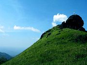
- RanipuramRanipuramRanipuram is a hill station located within Kasargod district of Kerala state, south India. It is located about east of Kanhangad on the Panathoor road branching off at Panathady and lies above sea level adjacent to Bhagamandala forest range.-History:Evidence of pre-settlement traditions exist in...
- A conglomerate of grassy hills near Panathady Town and linked to Kanhangad by Kanhangad-Panathur state highway. - Kottancheri HillsKottancheri HillsKottancheri Hills is a part of the Western Ghats in Kasaragod district of Kerala, south India. This is an area of rain forest near Konnakkad 30 km north- east of Kanhangad. It includes a picnic centre and is ideal for trekking. Talakaveri in the Brahmagiri mountain range of Kodagu is...
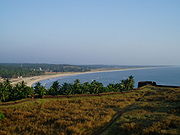
- Located near Talakaveri which is the starting point of the Kaveri river. It is 36 km from Kanhangad Town. - Valiyaparamba Backwaters.
Other tourist attractions are Chandragiri Fort, Anandashramam, Nithyanandashramam, and Kareem forest park - the only man made forest in the Kerala. The forest park is located in Parappa near Nileshwar. The Kerala State Government is planning to set up an IT park in Kasaragod. It will be constructed in 100 acre (0.404686 km²) of revenue land in Cheemeni which is estimated to generate around 50,000 IT jobs.
Pilgrim centres
- Ananthapura Lake Temple an ancient and attractive-looking temple dedicated to Lord Vishnu.
- Madhur Ganapathy Temple is an architecturally impressive structure.
- Mallikarjuna Temple is another temple in the heart of Kasargod Town and is dedicated to Lord Shiva.
- Palakunnu Bhagavathi temple.
- Mallam Temple.
- Mallik Deenar Mosque.
- Bela Church, also known as Our Lady of Sorrows Church, is a Roman Catholic church located 14 km north of Kasaragod and 50 km south of Mangalore. It was built in 1890 and is thus the oldest extant church in the district. This Gothic Revival Roman Catholic church, which is under the Mangalore Diocese, recently celebrated its centenary when it was also renovated. Bela Catholic Parish is also one of the oldest existing parishes of the Diocese of Mangalore. The mother tongue of the Catholics is Konkani.
Fauna and Flora
Kasaragod district surrounded by three forest districts - in the north by Dakshina Kannada (one NP and 2 wildlife sanctuaries), in the east by Kodagu (one NP and two wildlife sancturaies), and in the south by Kannur (one wildlife sanctuary and one elephant corridor). Even then, the forest officials of this district have not sent any proposal to the state forest department or the Central Government for setting up a sanctuary here, although shola, evergreen and mangrove forests exist in abundance.Kasaragod district is very rich in vegetation. Natural vegetation, except in some coastal regions, consists of different types of forests. But in spite of generally favourable climatic conditions, vegetation is not uniform. In restricted regions, with their own micro climate or special edaphic
Edaphic
Edaphic is a nature related to soil. Edaphic qualities may characterize the soil itself, including drainage, texture, or chemical properties such as pH. Edaphic may also characterize organisms, such as plant communities, where it specifies their relationships with soil...
features, plant formations assume different characters. Thus, plant communities, ranging from psammophytes and mangrove
Mangrove
Mangroves are various kinds of trees up to medium height and shrubs that grow in saline coastal sediment habitats in the tropics and subtropics – mainly between latitudes N and S...
s to evergreen forest
Evergreen forest
An temperate evergreen forest is a forest consisting entirely or mainly of evergreen trees that retain green foliage all year round. Such forests exist in the tropics primarily as broadleaf evergreens, and in temperate and boreal latitudes primarily as coniferous evergreens.-Tropical evergreen...
s are seen here.
Ranipuram Wildlife sanctaury (50 km2, proposed)
In Panathady RF, the proposed Ranipuram Wildlife sanctuary / National park of Kanhangad forest range consists of various flora and fauna which are endemic to the Western Ghats and a yet to studied biodiversity hotspot. It merges with the Talacauvery wildlife sanctuary. Ranipuram hill station
Ranipuram
Ranipuram is a hill station located within Kasargod district of Kerala state, south India. It is located about east of Kanhangad on the Panathoor road branching off at Panathady and lies above sea level adjacent to Bhagamandala forest range.-History:Evidence of pre-settlement traditions exist in...
which falls in Panathady reserve forest is an ideal area to notify as a wild life sanctuary/National park. Shola
Shola
Sholas are patches of stunted evergreen tropical and subtropical moist broadleaf forest found in valleys amid rolling grassland in the higher montane regions of South India. These patches of shola forest are found mainly in the valleys and are usually separated from one another by undulating...
forest seen only here in this district. Elephants, leopards, deer, wild dogs, wild boars, macaques, jungle cats, Leopard cats slender loris, porcupines, malabar giant squirrels, malabar civet cat, many species of birds, rare butterflies and medicinal plants are found in these forest.
Most of these highly endangered animals are killed by people due to lack of conversational awareness or to protect their crops. Ranipuram wild life sanctuary will be in contiguous to Talacauvery wildlife sanctuary in Karnataka
Karnataka
Karnataka , the land of the Kannadigas, is a state in South West India. It was created on 1 November 1956, with the passing of the States Reorganisation Act and this day is annually celebrated as Karnataka Rajyotsava...
. If it is declared as a wild life sanctuary, it will enhance the tourism industry of this district along with Ranipuram hill station/Biodiversity park. Declaring it as a wildlife sanctuary is the only way to protect this Westernghat biodiversity hotspot and permanent solution for Encroachment, Poaching, hunting in night, mining, Illegal tree felling which are main threats for this park.
The proposed Munnamkadavu Dam may very useful to create a fresh water and wetland ecosystem and sanctuary for wild crocodile, otter, endangered fish and water birds. Afforestation around the catchment area of dam reservoir will help to create another new wildlife sanctuary here in future and recreate lost wild elephant corridor.
Malom Wildlife Sanctuary (5 km2)
Malom reserve forest of Kanhangad range consists of Tropical rainforest and many wild animals like as rhesus monkey, wild pig, flying squirrels, slender loris, porcupine, and birds like peacock, Malabar hornbill and grey horn bill are seen. Snakes like cobras, python and king cobras reported. It is 28 km away east of Kanhangad in Balal-Kallar panchayath.
Adoor wildlife sanctuary (2 km2)
A Fragmented, Adoor reserve forest which spreads about 2 km2 in Kasaragod district is the home for endangered animals like jungle cat, slender loris, wild pig, porcupine, turtles, peacock, Malabar horn bill, butterflies, medicinal plants and wet evergreen forest. Illicit tree felling, hunting, encroachment are main threats for this sanctuary. It is about 35 km east of Kasaragod town in Adoor-Kuttikol panchayath.
Parappa wildlife sanctuary (2 km2)
A fragmented RF, Parappa reserve forest of Kanhangad range are home for jungle cats, slender loris, wild pig, porcupine, turtles, peacock, Malabar horn bill, butterflies, medicinal plants and wet evergreen forest. Illicit tree felling, hunting, encroachment are main threats for this sanctuary. It is about 22 km East of Chervathur town
Kammadam sacred grove wildlife sanctuary (50 acres)
Kammadam kavu, related with Bhagavathi temple, is the biggest sacred grove of Kerala and rich in wildlife, evergreen forest, orchids, medicinal plants and shrubs. Wild animals like Jungle cat, monitor lizard, civets, fox, bats, snakes, various species of birds and butterflies seen. It is 25 km east of Kanhangad town.
Kareem's Forest park (32 acres)
India's first private sanctuary which spreads across 32 acres (129,499.5 m²) and rich in diverse species of trees, medicinal plants, birds, insets, reptiles, amphibians, small wild animals, microorganisms and so on. People from different walks of life environmentalists, scientists, University and Ayurveda students, and laymen, all over the country visit his forest park for practical experience and study purpose. He is also multiplying and distributing the seeds and saplings of forest trees and medicinal plants and help our mother earth and help the nation to convert waste lands in to thick forests by replicating his efforts without involving additional coasts.
The park is situated at Puliyamkulam, near Parappa. It is 23 km away east of kanhangad town. Frequent bus service available.
Thalangara Children's Park
Located 4 km from Kasargod Town, Thalangara West, is located right next to the Fishing Harbour. Many water birds, spotted snakes, foxes also reported.
...BANGOD bay park
located 5 km away from kasaragod town,a beautiful park near to a mosque and madeena manzil, it is the best place for children's to enjoy and have fun in watergames etc.. this has a very wondurful garden with lovely flowers and many more funs...
National Movement
Kasaragod played a prominent role in the National Movement for the freedom of the country. Mohammed Sherul Sahib and Kandige Krishna Bhat were the frontline leaders of the independence movement. Umesh Rao, K. M. Krishnan Nambiar, Shreesankarji, Naranthatta Raman Nair, A. C. Kannan Nair, T. Gopalan Nair and Meloth Narayanan Nambiar were prominent freedom fighters.The agrarian struggle to end the exploitation and oppression by landlords and chieftains were part of the National Movement. The Kadakom Sathyagraha was started following the arrest of Gandhiji in 1932. The Palayi Harvest Agitation (1941), Cheemeni Estate Struggle (1942), Kayyur Agrarian Riot (1944), Eleri Estate Agitation (1946), Karinthalam Paddy Seizure Revolt (1948) and many other struggles waged by the peasant organisations accelerated the tempo of the freedom movement. Besides the agitation of the peasants, the various struggles unleashed for the uplift of the scheduled castes and tribes also supported and enlivened the National Movement.