
John Muir Trail
Encyclopedia
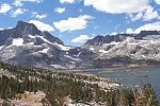
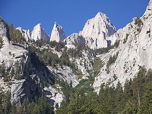
The John Muir Trail is a long-distance trail
in the Sierra Nevada mountain range of California
, running 211 miles (339.6 km) between the northern terminus at Happy Isles
in Yosemite Valley
(37.7317°N 119.5587°W) and the southern terminus located on the summit
of Mount Whitney
(36.5785°N 118.292°W). For almost all of its length, the trail is in the High Sierra
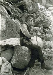
backcountry and wilderness areas. For about 160 miles (257.5 km), the trail, named for naturalist John Muir
, follows the same footpath as the longer Pacific Crest Trail
. It also passes through Kings Canyon National Park
and Sequoia National Park
.
(USGS), is 211 miles (339.6 km). From its northern terminus in Yosemite Valley, the trail runs northeast, passing south of Half Dome
and then on to Tuolumne Meadows. From Tuolumne Meadows the trail turns south, running parallel to the main range of the Sierra Nevada, through Yosemite National Park, Inyo
and Sierra
national forests (including the John Muir Wilderness
and Ansel Adams Wilderness
), passing through Devils Postpile National Monument, Kings Canyon National Park, and ending on Mount Whitney in Sequoia National Park. From the southern terminus of the JMT at the summit of Mount Whitney, an additional 11 miles (17.7 km) hike
on the Mount Whitney Trail
is required to reach the nearest trailhead
at Whitney Portal
, thus making an end-to-end traverse of the trail effectively 220 miles (354.1 km).
es in excess of 11000 feet (3,352.8 m); from north to south, they are: Donohue Pass, Muir Pass
, Mather Pass, Pinchot Pass, Glen Pass
, and Forester Pass
. At 13153 feet (4,009 m), Forester Pass is the highest point along the Pacific Crest Trail and the second-highest pass along the JMT (after Trail Crest on the Mount Whitney Trail).
When the length of the JMT was calculated by the USGS, elevation gain
and loss was not taken into consideration. It is estimated that, when hiking north to south, the amount of ascent of the JMT is just over 46000 feet (14,020.8 m) and the total descent is just over 38000 feet (11,582.4 m), for a total of about 84000 feet (25,603.2 m), or almost 16 miles (25.7 km); however, this does not mean the total length is increased by 16 miles (25.7 km).
 The idea of the trail along the backbone of the High Sierra originated with Theodore Solomons
. Solomons later recalled that the concept originated in his adolescence. "The idea of a crest-parallel trail came to me one day while herding my uncle's cattle in an immense unfenced alfalfa field near Fresno. It was 1884 and I was 14." He began advocating construction of the trail shortly after the Sierra Club
was founded in 1892. John Muir was a founding member and first president of the Sierra Club. Solomons explored the area now known as the Evolution Basin, and traveled extensively throughout the High Sierra, exploring possible trail routes. Joseph Nisbet LeConte
took up the cause in 1898 and the proposed trail was originally called the "High Sierra Trail", although that name was later given to a different trail
, running in the east-west direction. LeConte spent years exploring the canyons and passes of the Kings River
and Kern River
, and climbing peaks along the proposed trail. Along with James S. Hutchinson
and Duncan McDuffie
, he pioneered a high mountain route in 1908 from Yosemite National Park to Kings Canyon, roughly along the route of the modern JMT. In 28 days, they completed a trip of 228 miles through the high mountains, including several previously unexplored sections. In 1914, the Sierra Club appointed a committee to cooperate with the State of California to begin construction of the trail. John Muir died later that year, and the proposed trail was renamed in his honor.
Construction of the JMT began a year after Muir's death in 1915 with a $10,000 grant from the California legislature. State Engineer Wilbut F. McClure was responsible for selecting the final route. He secured the cooperation of the United States Forest Service
, which managed and supervised much of the actual construction. The California state legislature made additional appropriations of $10,000 each in 1917, 1925, 1927 and 1929.
After the Depression began, assistance from the California state government came to an end, and there were still two difficult sections yet to be completed. One was the connection from the Kings River to the Kern River over Forester Pass, at an elevation of 13153 feet (4,009 m). The Forester Pass section was completed in 1932 as the result of a joint effort between the Forest Service and the National Park Service
. The Forest Service completed the final section at Palisade Creek (in the Palisade Group
) in 1938. This section passes by the headwaters of the Middle Fork of the Kings River and over Mather Pass by the "Golden Staircase" to the headwaters of the South Fork of the Kings River. Shortly after, this section was incorporated into newly-created Kings Canyon National Park. The entire project had taken 46 years to complete. William Edward Colby
, the first secretary of the Sierra Club, called the finished trail "a most appropriate memorial to John Muir, who spent many of the best years of his life exploring the region which it will make accessible."
 The primary hiking season is usually from July through September, though snow may linger on the higher passes well into August following heavy snow years. Early season hikers—including Pacific Crest Trail thru-hikers
headed north for Canada
-- have to contend not only with the snowpack
and icy slopes near the passes, but with streams swollen with snowmelt
. Trail conditions are less demanding later in the season after the snowmelt concludes, and the weather generally remains pleasant for hiking through September. Weather during the hiking season is generally sunny and dry, but afternoon thunderstorms are not uncommon. The trail is used primarily by backpackers
and dayhikers, but also by runners
, trail riders
, and pack trains
. Backpackers travelling at a generous pace usually complete the trail within three weeks.
A permit is required to hike the JMT, which is obtained from the national park or forest where the hiker begins the hike. This single permit is valid for the entire hike. Permits can be hard to obtain for JMT thru-hikers. Both ends of the JMT, Yosemite and Whitney Portal have a lottery for wilderness permits. In addition, in Yosemite hikers face competition with other backpackers simply wanting to camp overnight while hiking Half Dome or to Tuolumne Meadows. Backpackers
entering the Sierra backcountry
on multi-day trips are generally required to carry their food in approved hard-sided storage containers known as bear canisters
to protect their food and other scented items from theft by black bears
, which are common in the region.
About 75-90 percent of hikers hike north to south, from Yosemite Valley to Mt. Whitney. There are advantages to starting in Yosemite Valley and hiking south. Although there is a significant net altitude gain this way, starting at a lower altitude allows the hiker time to acclimatize to the elevations of the trail rather than immediately having to tackle a 6,000-foot (1,800 m) climb to the summit of Mount Whitney. In addition, there are several resupply points convenient to the JMT during its northern half (Tuolumne Meadows, Reds Meadow, Vermillion Valley Resort, Muir Trail Ranch), allowing the hiker to carry a lighter food load early in the hike and also to exit the trail easily if problems arise. The southern half of the JMT is more remote and generally higher in elevation, thus making it more appropriate for the second half of the hike when maximum conditioning has been attained.
Long-distance trail
Long-distance trails are the longer recreational trails mainly through rural areas, used for non-motorised recreational travelling ....
in the Sierra Nevada mountain range of California
California
California is a state located on the West Coast of the United States. It is by far the most populous U.S. state, and the third-largest by land area...
, running 211 miles (339.6 km) between the northern terminus at Happy Isles
Happy Isles
Happy Isles is a group of small isles in the Merced River in Yosemite National Park, California, USA. They are located at the easternmost end of the Yosemite Valley floor...
in Yosemite Valley
Yosemite Valley
Yosemite Valley is a glacial valley in Yosemite National Park in the western Sierra Nevada mountains of California, carved out by the Merced River. The valley is about long and up to a mile deep, surrounded by high granite summits such as Half Dome and El Capitan, and densely forested with pines...
(37.7317°N 119.5587°W) and the southern terminus located on the summit
Summit (topography)
In topography, a summit is a point on a surface that is higher in elevation than all points immediately adjacent to it. Mathematically, a summit is a local maximum in elevation...
of Mount Whitney
Mount Whitney
Mount Whitney is the highest summit in the contiguous United States with an elevation of . It is on the boundary between California's Inyo and Tulare counties, west-northwest of the lowest point in North America at Badwater in Death Valley National Park...
(36.5785°N 118.292°W). For almost all of its length, the trail is in the High Sierra
High Sierra
High Sierra is an early heist film and film noir written by W.R. Burnett and John Huston from the novel by Burnett. The movie features Ida Lupino and Humphrey Bogart and was directed by Raoul Walsh on location at Whitney Portal, halfway up Mount Whitney.The screenplay was co-written by Bogart's...
backcountry and wilderness areas. For about 160 miles (257.5 km), the trail, named for naturalist John Muir
John Muir
John Muir was a Scottish-born American naturalist, author, and early advocate of preservation of wilderness in the United States. His letters, essays, and books telling of his adventures in nature, especially in the Sierra Nevada mountains of California, have been read by millions...
, follows the same footpath as the longer Pacific Crest Trail
Pacific Crest Trail
The Pacific Crest Trail is a long-distance mountain hiking and equestrian trail on the Western Seaboard of the United States. The southern terminus is at the California border with Mexico...
. It also passes through Kings Canyon National Park
Kings Canyon National Park
Kings Canyon National Park is a National Park in the southern Sierra Nevada, east of Fresno, California. The park was established in 1940 and covers...
and Sequoia National Park
Sequoia National Park
Sequoia National Park is a national park in the southern Sierra Nevada east of Visalia, California, in the United States. It was established on September 25, 1890. The park spans . Encompassing a vertical relief of nearly , the park contains among its natural resources the highest point in the...
.
Route
The official length of the JMT, as stated by the United States Geological SurveyUnited States Geological Survey
The United States Geological Survey is a scientific agency of the United States government. The scientists of the USGS study the landscape of the United States, its natural resources, and the natural hazards that threaten it. The organization has four major science disciplines, concerning biology,...
(USGS), is 211 miles (339.6 km). From its northern terminus in Yosemite Valley, the trail runs northeast, passing south of Half Dome
Half Dome
Half Dome is a granite dome in Yosemite National Park, located in northeastern Mariposa County, California, at the eastern end of Yosemite Valley — possibly Yosemite's most familiar rock formation. The granite crest rises more than above the valley floor....
and then on to Tuolumne Meadows. From Tuolumne Meadows the trail turns south, running parallel to the main range of the Sierra Nevada, through Yosemite National Park, Inyo
Inyo National Forest
Inyo National Forest is a federally administered forest in the United States. The forest covers parts of the eastern Sierra Nevada of California, and the White Mountains of California and Nevada. It contains two wilderness areas: the John Muir Wilderness and the Ansel Adams Wilderness...
and Sierra
Sierra National Forest
Sierra National Forest is a U.S. National Forest located on the western slope of central Sierra Nevada in the state of California. The forest is known for its mountain scenery and natural resources. Forest headquarters are located in Clovis, California...
national forests (including the John Muir Wilderness
John Muir Wilderness
The John Muir Wilderness is a wilderness area that extends along the crest of the Sierra Nevada of California, USA for , in the Inyo and Sierra National Forests. Established in 1964 by the Wilderness Act and named for naturalist John Muir, it contains...
and Ansel Adams Wilderness
Ansel Adams Wilderness
The Ansel Adams Wilderness is a wilderness area in the Sierra Nevada of California, USA. The wilderness is part of the Sierra and Inyo National Forests. The wilderness spans...
), passing through Devils Postpile National Monument, Kings Canyon National Park, and ending on Mount Whitney in Sequoia National Park. From the southern terminus of the JMT at the summit of Mount Whitney, an additional 11 miles (17.7 km) hike
Hiking
Hiking is an outdoor activity which consists of walking in natural environments, often in mountainous or other scenic terrain. People often hike on hiking trails. It is such a popular activity that there are numerous hiking organizations worldwide. The health benefits of different types of hiking...
on the Mount Whitney Trail
Mount Whitney trail
The Mount Whitney Trail is a trail that climbs Mount Whitney. It starts at Whitney Portal, west of the town of Lone Pine, California. The hike is about round trip, with an elevation gain of over...
is required to reach the nearest trailhead
Trailhead
A trailhead is the point at which a trail begins, where the trail is often intended for hiking, biking, horseback riding, or off-road vehicles...
at Whitney Portal
Whitney Portal, California
Whitney Portal is an unincorporated community in Inyo County, California. It is located west of Lone Pine, at an elevation of 7851 feet . Whitney Portal, as its name suggests, is the gateway to Mount Whitney, the highest point in the contiguous United States; it is the trailhead for the Mount...
, thus making an end-to-end traverse of the trail effectively 220 miles (354.1 km).
Elevation
With the exception of the first 9 miles (14.5 km) at the northern end climbing out of Yosemite Valley, the elevation of the JMT seldom dips below 8000 feet (2,438.4 m). The trail crosses six mountain passMountain pass
A mountain pass is a route through a mountain range or over a ridge. If following the lowest possible route, a pass is locally the highest point on that route...
es in excess of 11000 feet (3,352.8 m); from north to south, they are: Donohue Pass, Muir Pass
Muir Pass
Muir Pass is a mountain pass in the Sierra Nevada of California, United States, in Kings Canyon National Park. It is named for John Muir.The pass is near the midway point of the John Muir Trail, which traverses the pass. It crosses the Goddard Divide between Mount Solomons and Mount Warlow, at an...
, Mather Pass, Pinchot Pass, Glen Pass
Glen Pass
Glen Pass is a mountain pass in the Sierra Nevada Mountains, located in Kings Canyon National Park, eastern Fresno County, California. This pass, on the John Muir Trail, links Rae Lakes at elevation with Charlotte Lake at elevation....
, and Forester Pass
Forester Pass
Forester Pass is a mountain pass in the Sierra Nevada. Located on the Kings-Kern Divide on the boundary between Sequoia National Park and Kings Canyon National Park, Forester Pass connects the drainages of Bubbs Creek and the Kern River...
. At 13153 feet (4,009 m), Forester Pass is the highest point along the Pacific Crest Trail and the second-highest pass along the JMT (after Trail Crest on the Mount Whitney Trail).
When the length of the JMT was calculated by the USGS, elevation gain
Cumulative elevation gain
In running, cycling, and mountaineering, cumulative elevation gain refers to the sum of every gain in elevation throughout an entire trip. It is sometimes also known as cumulative gain or elevation gain, or often in the context of mountain travel, simply gain. Elevation losses are not counted in...
and loss was not taken into consideration. It is estimated that, when hiking north to south, the amount of ascent of the JMT is just over 46000 feet (14,020.8 m) and the total descent is just over 38000 feet (11,582.4 m), for a total of about 84000 feet (25,603.2 m), or almost 16 miles (25.7 km); however, this does not mean the total length is increased by 16 miles (25.7 km).
History
Theodore Solomons
Theodore Seixas Solomons was an explorer and early member of the Sierra Club. From 1892 to 1897 he explored and named the Mount Goddard, Evolution Valley and Evolution Basin region in what is now northern Kings Canyon National Park in eastern California...
. Solomons later recalled that the concept originated in his adolescence. "The idea of a crest-parallel trail came to me one day while herding my uncle's cattle in an immense unfenced alfalfa field near Fresno. It was 1884 and I was 14." He began advocating construction of the trail shortly after the Sierra Club
Sierra Club
The Sierra Club is the oldest, largest, and most influential grassroots environmental organization in the United States. It was founded on May 28, 1892, in San Francisco, California, by the conservationist and preservationist John Muir, who became its first president...
was founded in 1892. John Muir was a founding member and first president of the Sierra Club. Solomons explored the area now known as the Evolution Basin, and traveled extensively throughout the High Sierra, exploring possible trail routes. Joseph Nisbet LeConte
Joseph Nisbet LeConte
Joseph Nisbet LeConte was a noted explorer of the Sierra Nevada. He was also a cartographer, a photographer and a professor of mechanical engineering. He often went by J. N. LeConte in photographs and articles...
took up the cause in 1898 and the proposed trail was originally called the "High Sierra Trail", although that name was later given to a different trail
High Sierra Trail
The High Sierra Trail is a hiking trail in Sequoia National Park, California. The trail crosses the Sierra Nevada from west to east.From the plateau of the Giant Forest at Crescent Meadow the trail travels high on the northern wall of the canyon of the Middle Fork of the Kaweah River to Bearpaw...
, running in the east-west direction. LeConte spent years exploring the canyons and passes of the Kings River
Kings River (California)
The Kings River is a major river of south-central California. About long, it drains an area of the high western Sierra Nevada and the Central Valley. A large alluvial fan has formed where the river's gradient decreases in the Central Valley so the river divides into distributaries...
and Kern River
Kern River
The Kern River is a river in the U.S. state of California, approximately long. It drains an area of the southern Sierra Nevada mountains northeast of Bakersfield. Fed by snowmelt near Mount Whitney, the river passes through scenic canyons in the mountains and is a popular destination for...
, and climbing peaks along the proposed trail. Along with James S. Hutchinson
James S. Hutchinson
James Sather Hutchinson was a lawyer in San Francisco, California, a mountaineer and an environmentalist. He was most noted for being an explorer of the Sierra Nevada....
and Duncan McDuffie
Duncan McDuffie
Duncan McDuffie was a real estate developer, conservationist, and mountaineer based in Berkeley, California, USA.-Visionary developer:...
, he pioneered a high mountain route in 1908 from Yosemite National Park to Kings Canyon, roughly along the route of the modern JMT. In 28 days, they completed a trip of 228 miles through the high mountains, including several previously unexplored sections. In 1914, the Sierra Club appointed a committee to cooperate with the State of California to begin construction of the trail. John Muir died later that year, and the proposed trail was renamed in his honor.
Construction of the JMT began a year after Muir's death in 1915 with a $10,000 grant from the California legislature. State Engineer Wilbut F. McClure was responsible for selecting the final route. He secured the cooperation of the United States Forest Service
United States Forest Service
The United States Forest Service is an agency of the United States Department of Agriculture that administers the nation's 155 national forests and 20 national grasslands, which encompass...
, which managed and supervised much of the actual construction. The California state legislature made additional appropriations of $10,000 each in 1917, 1925, 1927 and 1929.
After the Depression began, assistance from the California state government came to an end, and there were still two difficult sections yet to be completed. One was the connection from the Kings River to the Kern River over Forester Pass, at an elevation of 13153 feet (4,009 m). The Forester Pass section was completed in 1932 as the result of a joint effort between the Forest Service and the National Park Service
National Park Service
The National Park Service is the U.S. federal agency that manages all national parks, many national monuments, and other conservation and historical properties with various title designations...
. The Forest Service completed the final section at Palisade Creek (in the Palisade Group
Palisades (California Sierra)
The Palisades are a group of peaks in the central part of the Sierra Nevada in the US state of California. They are located about southwest of the town of Big Pine, California...
) in 1938. This section passes by the headwaters of the Middle Fork of the Kings River and over Mather Pass by the "Golden Staircase" to the headwaters of the South Fork of the Kings River. Shortly after, this section was incorporated into newly-created Kings Canyon National Park. The entire project had taken 46 years to complete. William Edward Colby
William Edward Colby
right|225pxWilliam Edward Colby was an American lawyer, conservationist, and first Secretary of the Sierra Club.-Early life and education:...
, the first secretary of the Sierra Club, called the finished trail "a most appropriate memorial to John Muir, who spent many of the best years of his life exploring the region which it will make accessible."
Hiking
Thru-hiking
Thru-hiking is the process of hiking a long-distance trail from end to end. The term is most commonly associated with the Appalachian Trail, but is also used for other lengthy trails and long distance hikes, including the Pacific Crest Trail and the Continental Divide Trail. Thru-hiking is also...
headed north for Canada
Canada
Canada is a North American country consisting of ten provinces and three territories. Located in the northern part of the continent, it extends from the Atlantic Ocean in the east to the Pacific Ocean in the west, and northward into the Arctic Ocean...
-- have to contend not only with the snowpack
Snowpack
Snowpack forms from layers of snow that accumulate in geographic regions and high altitudes where the climate includes cold weather for extended periods during the year. Snowpacks are an important water resource that feed streams and rivers as they melt. Snowpacks are the drinking water source for...
and icy slopes near the passes, but with streams swollen with snowmelt
Snowmelt
In hydrology, snowmelt is surface runoff produced from melting snow. It can also be used to describe the period or season during which such runoff is produced. Water produced by snowmelt is an important part of the annual water cycle in many parts of the world, in some cases contributing high...
. Trail conditions are less demanding later in the season after the snowmelt concludes, and the weather generally remains pleasant for hiking through September. Weather during the hiking season is generally sunny and dry, but afternoon thunderstorms are not uncommon. The trail is used primarily by backpackers
Backpacking (wilderness)
Backpacking combines the activities of hiking and camping for an overnight stay in backcountry wilderness...
and dayhikers, but also by runners
Trail running
Trail running is a variant on running that differs markedly from road running and track running. Trail running generally takes place on hiking trails, most commonly single track trails, although fire roads are not uncommon. A distinguishing characteristic of the trails is that they are often...
, trail riders
Trail riding
Trail riding sometimes called horse or pony trekking is riding outdoors on natural trails and roads as opposed to riding in an enclosed area such as a riding arena. The term may encompass those who travel on horses, on mountain bikes, or on motorcycles and other motorized all-terrain vehicles...
, and pack trains
Packhorse
.A packhorse or pack horse refers generally to an equid such as a horse, mule, donkey or pony used for carrying goods on their backs, usually carried in sidebags or panniers. Typically packhorses are used to cross difficult terrain, where the absence of roads prevents the use of wheeled vehicles. ...
. Backpackers travelling at a generous pace usually complete the trail within three weeks.
A permit is required to hike the JMT, which is obtained from the national park or forest where the hiker begins the hike. This single permit is valid for the entire hike. Permits can be hard to obtain for JMT thru-hikers. Both ends of the JMT, Yosemite and Whitney Portal have a lottery for wilderness permits. In addition, in Yosemite hikers face competition with other backpackers simply wanting to camp overnight while hiking Half Dome or to Tuolumne Meadows. Backpackers
Backpacking (wilderness)
Backpacking combines the activities of hiking and camping for an overnight stay in backcountry wilderness...
entering the Sierra backcountry
Backcountry
A backcountry area in general terms is a geographical region that is:* isolated* remote* undeveloped* difficult to accessThe term may apply to various regions that are reasonably close to urban areas but are:* not immediately accessible by car...
on multi-day trips are generally required to carry their food in approved hard-sided storage containers known as bear canisters
Bear-resistant food storage container
Bear-resistant food storage containers, commonly called bear canisters or simply bear cans, are usually hard-sided containers used by backpackers to protect their food from theft by bears...
to protect their food and other scented items from theft by black bears
American black bear
The American black bear is a medium-sized bear native to North America. It is the continent's smallest and most common bear species. Black bears are omnivores, with their diets varying greatly depending on season and location. They typically live in largely forested areas, but do leave forests in...
, which are common in the region.
About 75-90 percent of hikers hike north to south, from Yosemite Valley to Mt. Whitney. There are advantages to starting in Yosemite Valley and hiking south. Although there is a significant net altitude gain this way, starting at a lower altitude allows the hiker time to acclimatize to the elevations of the trail rather than immediately having to tackle a 6,000-foot (1,800 m) climb to the summit of Mount Whitney. In addition, there are several resupply points convenient to the JMT during its northern half (Tuolumne Meadows, Reds Meadow, Vermillion Valley Resort, Muir Trail Ranch), allowing the hiker to carry a lighter food load early in the hike and also to exit the trail easily if problems arise. The southern half of the JMT is more remote and generally higher in elevation, thus making it more appropriate for the second half of the hike when maximum conditioning has been attained.
See also
- Ecology of the Sierra Nevada
- Long-distance trails in the United StatesLong-distance trails in the United StatesThe following is a list of long-distance trails in the United States:- See also :*National Millennium Trail project - 16 long-distance trails selected in 2000 as visionary trails that reflect defining aspects America's history and culture...
- Sierra High RouteSierra High RouteThe Sierra High Route is a cross-country hiking route, long, through the Sierra Nevada. It was scouted by Steve Roper and described by him in his book Sierra High Route: Traversing Timberline Country....
External links
- John Muir Trail Documentary in HD (40 minutes that cover the entire trail
- Elevation profile for the JMT with high resolution available
- Information about hiking the John Muir Trail
- John Muir Trail planning info and general long distance hiking tips
- Panoramic photos taken along the JMT
- Journals of many JMT hikes
- Story about an unsuccessful unsupported JMT thru-run
- A personal account of a JMT thru-hike completed in September 2007
- A free set of JMT Topo Maps
- Video account of a backpacking trip along the JMT
- Video account of a JMT thru-hike in Summer 2011