
High Sierra Trail
Encyclopedia
The High Sierra Trail is a hiking
trail
in Sequoia National Park
, California
. The trail crosses the Sierra Nevada from west to east.
From the plateau of the Giant Forest
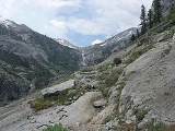
at Crescent Meadow the trail travels high on the northern wall of the canyon of the Middle Fork of the Kaweah River
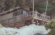
to Bearpaw Meadow. This first 11.4 miles (18.3 km) of the trail is a popular though strenuous two day round trip hike. The "Bearpaw High Sierra Camp" (a simple tent hotel) located here dates back to 1934.
 Leaving the meadow the trail climbs through the Hamilton Lakes Basin to Kaweah Gap
which at 10700 feet (3,261 m) it is one of the lowest passes over the Great Western Divide
within the park. From this pass the route descends into Big Arroyo and then climbs to the Chagoopa Plateau only to drop again into the Kern River
Canyon. After following along the Kern River it turns east and climbs parallel to Wallace Creek to the junction with the John Muir Trail
and Pacific Crest Trail
48.9 miles (78.7 km) from the Crescent Meadow. This is considered to be the end of the High Sierra Trail but hikers may wish to continue on the John Muir Trail 12.6 miles (20.3 km) to the summit of Mount Whitney
.
For those wishing to complete the crossing of the High Sierra the Mount Whitney Trail
branches to the east from the John Muir Trail 2.4 miles (3.9 km) south of Mount Whitney's summit and descends to Whitney Portal located at the end of the road from Lone Pine, California
. From Crescent Meadow to Whitney Portal the trail is 72.2 miles (116.2 km) long and is often hiked in 6 to 7 days or more. It is occasionally performed in even less time by experts.
Work began on the High Sierra Trail in 1928 and it was the first Sierra trail built solely for recreational purposes.
Users should check with park rangers before planning a trip with riding or pack stock. At least one section of the trail is closed to stock and grazing is limited in many areas.
Hiking
Hiking is an outdoor activity which consists of walking in natural environments, often in mountainous or other scenic terrain. People often hike on hiking trails. It is such a popular activity that there are numerous hiking organizations worldwide. The health benefits of different types of hiking...
trail
Trail
A trail is a path with a rough beaten or dirt/stone surface used for travel. Trails may be for use only by walkers and in some places are the main access route to remote settlements...
in Sequoia National Park
Sequoia National Park
Sequoia National Park is a national park in the southern Sierra Nevada east of Visalia, California, in the United States. It was established on September 25, 1890. The park spans . Encompassing a vertical relief of nearly , the park contains among its natural resources the highest point in the...
, California
California
California is a state located on the West Coast of the United States. It is by far the most populous U.S. state, and the third-largest by land area...
. The trail crosses the Sierra Nevada from west to east.
From the plateau of the Giant Forest
Giant Forest
The Giant Forest, famed for its giant sequoia trees, is within Sequoia National Park. This montane forest, situated at over above mean sea level in the western Sierra Nevada of California, covers an area of...
at Crescent Meadow the trail travels high on the northern wall of the canyon of the Middle Fork of the Kaweah River
Kaweah River
The Kaweah River in the U.S. state of California flows westward from the foothills of the Sierra Nevada into the Central Valley. It rises in forks in the southern Sierra Nevada inside Sequoia National Park, the longest of which is the Middle Fork, about long...
to Bearpaw Meadow. This first 11.4 miles (18.3 km) of the trail is a popular though strenuous two day round trip hike. The "Bearpaw High Sierra Camp" (a simple tent hotel) located here dates back to 1934.
Kaweah Gap
The Kaweah Gap is the lowest east-west pass through the Great Western Divide, in Sequoia National Park, California, USA. The High Sierra Trail is routed through this pass....
which at 10700 feet (3,261 m) it is one of the lowest passes over the Great Western Divide
Great Western Divide
The Great Western Divide is a Sierra Nevada mountain range that forms part of the border between the Kings Canyon and Sequoia National Parks. The High Sierra Trail crosses the range at Kaweah Gap from Sequoia National Park.- References :...
within the park. From this pass the route descends into Big Arroyo and then climbs to the Chagoopa Plateau only to drop again into the Kern River
Kern River
The Kern River is a river in the U.S. state of California, approximately long. It drains an area of the southern Sierra Nevada mountains northeast of Bakersfield. Fed by snowmelt near Mount Whitney, the river passes through scenic canyons in the mountains and is a popular destination for...
Canyon. After following along the Kern River it turns east and climbs parallel to Wallace Creek to the junction with the John Muir Trail
John Muir Trail
The John Muir Trail is a long-distance trail in the Sierra Nevada mountain range of California, running between the northern terminus at Happy Isles in Yosemite Valley and the southern terminus located on the summit of Mount Whitney . For almost all of its length, the trail is in the High Sierra...
and Pacific Crest Trail
Pacific Crest Trail
The Pacific Crest Trail is a long-distance mountain hiking and equestrian trail on the Western Seaboard of the United States. The southern terminus is at the California border with Mexico...
48.9 miles (78.7 km) from the Crescent Meadow. This is considered to be the end of the High Sierra Trail but hikers may wish to continue on the John Muir Trail 12.6 miles (20.3 km) to the summit of Mount Whitney
Mount Whitney
Mount Whitney is the highest summit in the contiguous United States with an elevation of . It is on the boundary between California's Inyo and Tulare counties, west-northwest of the lowest point in North America at Badwater in Death Valley National Park...
.
For those wishing to complete the crossing of the High Sierra the Mount Whitney Trail
Mount Whitney trail
The Mount Whitney Trail is a trail that climbs Mount Whitney. It starts at Whitney Portal, west of the town of Lone Pine, California. The hike is about round trip, with an elevation gain of over...
branches to the east from the John Muir Trail 2.4 miles (3.9 km) south of Mount Whitney's summit and descends to Whitney Portal located at the end of the road from Lone Pine, California
Lone Pine, California
Lone Pine is a census-designated place in Inyo County, California, United States. Lone Pine is located south-southeast of Independence, at an elevation of 3727 feet . The population was 2,035 at the 2010 census, up from 1,655 at the 2000 census. The town is located in the Owens Valley, near the...
. From Crescent Meadow to Whitney Portal the trail is 72.2 miles (116.2 km) long and is often hiked in 6 to 7 days or more. It is occasionally performed in even less time by experts.
Work began on the High Sierra Trail in 1928 and it was the first Sierra trail built solely for recreational purposes.
Users should check with park rangers before planning a trip with riding or pack stock. At least one section of the trail is closed to stock and grazing is limited in many areas.