

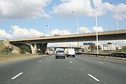
Johannesburg freeways
Encyclopedia
Sea level
Mean sea level is a measure of the average height of the ocean's surface ; used as a standard in reckoning land elevation...
, far from the coast or any major bodies of water. There are 10 freeways in the Greater Johannesburg Metropolitan Area
Greater Johannesburg Metropolitan Area
The Greater Johannesburg Metropolitan Area is the name of the area surrounding the city of Johannesburg, in South Africa. It includes Johannesburg and the areas of the East Rand and West Rand. It is often referred to as the Witwatersrand, or Rand, after a low mountain range that runs through the...
: the N1
N1 (South Africa)
The N1 is a South African National Route, running from Cape Town to Beit Bridge on the border with Zimbabwe. It is also the main road link between Johannesburg and Cape Town, and forms the first section of the famed Cape to Cairo Road....
, N3
N3 (South Africa)
The N3 is a National Route in South Africa, connecting Johannesburg and Durban, respectively South Africa's largest and third-largest cities. Johannesburg is the financial and commercial heartland of South Africa, while Durban is South Africa's key port and one of the busiest ports in the Southern...
, N12
N12 (South Africa)
The N12 is a National Route in South Africa. It is maintained by the South African National Roads Agency.- Route :The road starts in George in the Western Cape and ends in Witbank in Mpumalanga. The road runs roughly from south to north, however, once it passes Kimberley in the Northern Cape, it...
, N14
N14 (South Africa)
The N14 is a South African National Route, running from Springbok in the Northern Cape to Pretoria. It passes through Upington, Kuruman, Vryburg, Krugersdorp and Centurion....
, N17
N17 (South Africa)
The N17 is a South African National Route, designed in the 1980s as an international link between Johannesburg and Swaziland at Oshoek/Ngwenya. It passes through Springs, Bethal and Ermelo....
, R21
R21 (Gauteng)
The R21 is a major north-south Regional Route in eastern Gauteng Province, South Africa. Built in the early 1970's, it remains the only other freeway that links Pretoria with Johannesburg, via the R24...
, R24
R24 (Gauteng)
The R24 is a major East-West Regional Route in the Greater Johannesburg Metropolitan Area that links OR Tambo International Airport with Rustenburg via Johannesburg, Krugersdorp and Magaliesburg....
, R59
R59 (Free State)
The R59 is a Regional Route in South Africa that connects Hertzogville with Alberton via Parys and Vereeniging.-External links:*...
, M1
M1 (Johannesburg)
The M1 De Villiers Graaff motorway is a major freeway in Johannesburg, South Africa. The highway connects the southern areas with the city centre and extends further north through Sandton...
and M2
M2 (Johannesburg)
The M2 is a major highway in Johannesburg, South Africa. It is named the Francois Oberholzer Freeway. It runs just to the South of the Central Business District eastwards where it connects with the N3 . The north-south M1 intersects with the M2 just to the east of the CBD....
. In addition, three new freeways are planned: the G5, G9 and G14. Freeways are sometimes called highways or motorways colloquially.
The N1, N3, and N12 form the Johannesburg Ring Road
Johannesburg Ring Road
The Johannesburg Ring Road is Africa's most famous beltway. It is made up of a subset of the freeways that circle the city of Johannesburg, South Africa and services the Greater Johannesburg Metropolitan Area. Construction on the Ring Road began in the late 1960s...
around the city. The N14 connects the West Rand
West Rand
The West Rand is the name of the urban western part of the Witwatersrand that is functionally merged with the Johannesburg conurbation. This area became settled by Europeans after a gold-bearing reef discovered in 1886 and sparked the gold rush that gave rise to the establishment of...
with Pretoria
Pretoria
Pretoria is a city located in the northern part of Gauteng Province, South Africa. It is one of the country's three capital cities, serving as the executive and de facto national capital; the others are Cape Town, the legislative capital, and Bloemfontein, the judicial capital.Pretoria is...
, and could possibly form part of a future Johannesburg second outer ring road. The N17 connects the Johannesburg
Johannesburg
Johannesburg also known as Jozi, Jo'burg or Egoli, is the largest city in South Africa, by population. Johannesburg is the provincial capital of Gauteng, the wealthiest province in South Africa, having the largest economy of any metropolitan region in Sub-Saharan Africa...
Central Business District
Central Business District (Johannesburg)
The Central Business District, commonly called Johannesburg CBD, is one of the main business centres of Johannesburg, South Africa. It is the most dense collection of skyscrapers in Africa, however due to white flight and urban blight, many of the buildings are unoccupied as tenants have left for...
and southern parts of the city with Springs
Springs, Gauteng
Springs is a city on the East Rand in the Gauteng province of South Africa.It lies 50 km east of Johannesburg. The name of the city derives from the large number of springs in the area; it has a population of more than 200,000, and is situated at 5,340 ft a.s.l...
on the East Rand and the province of Mpumalanga
Mpumalanga
Mpumalanga , is a province of South Africa. The name means east or literally "the place where the sun rises" in Swazi, Xhosa, Ndebele and Zulu. Mpumalanga lies in eastern South Africa, north of KwaZulu-Natal and bordering Swaziland and Mozambique. It constitutes 6.5% of South Africa's land area...
. The R21 connects the East Rand and OR Tambo International Airport with Pretoria. The R24 connects central Johannesburg to the airport. The R59 connects Johannesburg with Vereeniging
Vereeniging, Gauteng
Vereeniging is a city in Gauteng province, South Africa. It is also one of the constituent parts of the Vaal Triangle region and was formerly situated in the Transvaal province...
in the Vaal Triangle
Vaal Triangle
The Vaal Triangle is a triangular area of land formed by Vereeniging, Vanderbijlpark and Sasolburg - together they comprise a substantial urban complex in South Africa...
. The M1 runs the length of the city north-south, from Soweto
Soweto
Soweto is a lower-class-populated urban area of the city of Johannesburg in Gauteng, South Africa, bordering the city's mining belt in the south. Its name is an English syllabic abbreviation for South Western Townships...
to Buccleuch, where it becomes the N1. The Johannesburg-Pretoria highway is also called the Ben Schoeman Highway. The M2 runs the length of the central part of the city east-west, from Germiston
Germiston, Gauteng
Germiston is a city in the East Rand of Gauteng in South Africa. Germiston is now the seat of the Ekurhuleni Metropolitan Municipality which includes much of the East Rand, and is also considered part of Greater Johannesburg.-History:...
to Main Reef Road.
The N1 between Johannesburg and Pretoria is now becoming severely overloaded. Reports suggest that the road carries 160,000 vehicles a day between the two cities. The road is heavily congested as traffic enters Johannesburg in the mornings and leaves at night, as many people work in Johannesburg but live in Pretoria. As a result, the Gauteng Provincial Government has put in motion plans to alleviate heavy traffic congestion, which is likely to worsen. One plan that is scheduled to be completed before South Africa hosts the 2010 FIFA World Cup
2010 FIFA World Cup
The 2010 FIFA World Cup was the 19th FIFA World Cup, the world championship for men's national association football teams. It took place in South Africa from 11 June to 11 July 2010...
is the Gautrain
Gautrain
Gautrain is an mass rapid transit railway system in Gauteng Province, South Africa, which links Johannesburg, Pretoria, and OR Tambo International Airport...
: a rapid rail
Rail transport
Rail transport is a means of conveyance of passengers and goods by way of wheeled vehicles running on rail tracks. In contrast to road transport, where vehicles merely run on a prepared surface, rail vehicles are also directionally guided by the tracks they run on...
system with a north-south line between Johannesburg and Pretoria, and an east-west line between OR Tambo International Airport and Sandton
Sandton, Gauteng
Sandton is a wealthy area situated within the metro of Johannesburg, Gauteng, South Africa. The name comes from the combination of two of its suburbs, Sandown and Bryanston...
.
The Star and Engineering News report that three new freeways have been planned for Johannesburg:
- The G9, linking the northern part of Johannesburg with the western part of Pretoria, aligned along the existing R80 axis known as the Mabopane Freeway. It will run parallel to the N1 and will intersect with the N14.
- The G5, which will link the R21 with the new G9, crossing the N1 at the Olifantsfontein interchange.
- The G14 will provide a new link between the existing M2 and OR Tambo International Airport via Germiston.
In addition, there are plans afoot to extend the N17 from its end in Johannesburg central, to Krugersdorp, which will allow motorists to traverse the metropolitan area in under an hour in free-flowing traffic.