

Jabal al-Tair Island
Encyclopedia
Jabal al-Tair Island is a roughly oval volcanic
island northwest of the constricted Bab al-Mandab passage at the mouth of the Red Sea
, about half way between Yemen
and Eritrea
. From 1996 until it erupted in 2007 Yemen maintained two watchtower
s and a small military base
on the island.
After 124 years of dormancy, the volcano that created the island erupted on 30 September 2007.
115 kilometres (71.5 mi) to the east and Eritrea
about 150 km (93 mi) south west. It is about 82 kilometres (51 mi) from the Yemeni Kamaran Island; the Saudi Arabia
n Farasan Islands
lie to the north east.
 The island comprises the basalt
ic stratovolcano
Jabal al-Tair (Tair Mountain; , literally, "Bird Mountain") rising from seabed some 1200 metres (3,937 ft) below the surface of the Red Sea, continuing for 244 m (801 feet) above the surface up to the summit of the crater
. The volcano was considered "recently
extinct" as of 1982.
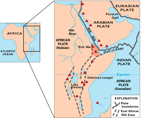
It was the northernmost known Holocene
volcano in the Red Sea, with one central vent, Jebel Duchan. It lies in the volcanic and geologically active region of the Red Sea Rift
, the divergent boundary
between the African Plate
and the Arabian Plate
.
In 1900 the British Admiralty described the island as having no natural water supply
, and having a high conical peak rising above a basalt bluff some 300 feet (91.4 m) above a gradual littoral
. The prominent profile made it an ideal landmark for Red Sea shipping, and the steep drop-off below sea level meant that it might be safely run for.
The island has no settled population, but some parts of the island have allowed for the seasonal presence of fishermen.
was an important navigational marker for the shipping lanes that passed nearby. Historically, the Ottoman Empire
controlled the Red Sea islands, and granted a French
company a lighthouse
concession. British
forces occupied the island in 1915, but sovereignty was deliberately left indeterminate. After a period of French-British operation the lighthouse concession passed to a British company, then to Yemen.
Sovereignty of the island was long disputed among Ethiopia
, Eritrea
, and Yemen. Under a 1962 agreement, lighthouses were maintained on the island at the cost of shippers. In 1973, Yemen had notified Ethiopia of its intent to perform an aerial survey, and an ambiguous response by Ethiopia was later a point of contention; Ethiopia designated the islands in the area as having "no recognized owner".
The dispute, after Eritrea's 1993 independence from Ethiopia, erupted into the 1995 Hanish islands crisis regarding the Hanish Islands
and Zuqar Island
.
A 1998-99 international case at the Permanent Court of Arbitration
awarded various islands to Eritrea and Yemen respectively.
Yemen maintained a military base on the island from the dispute with Eritrea in 1996 until the 2007 eruption. There are or were two watchtowers for control and observation of the large warships, cargo ships, and oil tankers that pass by.
 The volcano
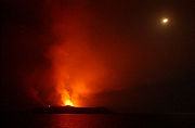
erupted at 7 p.m. local time on 30 September 2007, throwing lava
and ash hundreds of meters into the air. Subsequently, at least one stream of lava was seen flowing down into the sea. It was reported that 29 Yemeni soldiers (around 50 according to one report) were evacuated from the island shortly before the eruption, but 8 were unaccounted for. Several bodies were recovered from the water.
It was reported that the western part of the island, where the Yemeni military base was, had collapsed.
Yemeni authorities requested help from a nearby NATO naval force, and the nearest ship, a United States Naval vessel USS Bainbridge, was reported to be aiding the Yemeni coastguard.
Other ships from NATO Standing NRF Maritime Group 1
assisted in the rescue and recovery effort, including the HMCS Toronto
; the Bainbridge and Toronto each rescued one survivor. The Portuguese
frigate
NRP Álvares Cabral and the Dutch
frigate HNLMS Evertsen
were first on the scene.
Both survivors were rescued after over 20 hours in the water, just as the task force was preparing to close down its search. A Canadian officer described a "spectacular backdrop of erupting lava and shooting flames" faced by search parties in small boats.
 Several minor earthquakes ranging from 2 to 3.6 on the moment magnitude scale
were reported near the island in the two weeks before the eruption.
Earlier documented eruptions of this volcano include several reported in the 18th and 19th centuries, the most recent (before 2007) in 1883, and possibly one in 1332.
A Yemeni government geologist
expects the volcano to "take time to calm down",
but shipping, including tankers carrying 3 million barrels of oil, that pass through the Red Sea daily, have not been affected.
In December 2007 it was reported that activity on the island had increased and fishermen were warned to avoid the area.
Volcano
2. Bedrock3. Conduit 4. Base5. Sill6. Dike7. Layers of ash emitted by the volcano8. Flank| 9. Layers of lava emitted by the volcano10. Throat11. Parasitic cone12. Lava flow13. Vent14. Crater15...
island northwest of the constricted Bab al-Mandab passage at the mouth of the Red Sea
Red Sea
The Red Sea is a seawater inlet of the Indian Ocean, lying between Africa and Asia. The connection to the ocean is in the south through the Bab el Mandeb strait and the Gulf of Aden. In the north, there is the Sinai Peninsula, the Gulf of Aqaba, and the Gulf of Suez...
, about half way between Yemen
Yemen
The Republic of Yemen , commonly known as Yemen , is a country located in the Middle East, occupying the southwestern to southern end of the Arabian Peninsula. It is bordered by Saudi Arabia to the north, the Red Sea to the west, and Oman to the east....
and Eritrea
Eritrea
Eritrea , officially the State of Eritrea, is a country in the Horn of Africa. Eritrea derives it's name from the Greek word Erethria, meaning 'red land'. The capital is Asmara. It is bordered by Sudan in the west, Ethiopia in the south, and Djibouti in the southeast...
. From 1996 until it erupted in 2007 Yemen maintained two watchtower
Watchtower
A watchtower is a type of fortification used in many parts of the world. It differs from a regular tower in that its primary use is military, and from a turret in that it is usually a freestanding structure. Its main purpose is to provide a high, safe place from which a sentinel or guard may...
s and a small military base
Military base
A military base is a facility directly owned and operated by or for the military or one of its branches that shelters military equipment and personnel, and facilitates training and operations. In general, a military base provides accommodations for one or more units, but it may also be used as a...
on the island.
After 124 years of dormancy, the volcano that created the island erupted on 30 September 2007.
Geography
The island is roughly oval, about 3 kilometres (1.9 mi) long, and 3.9 square kilometres (1.5 sq mi) in area. It lies nearly half way between YemenYemen
The Republic of Yemen , commonly known as Yemen , is a country located in the Middle East, occupying the southwestern to southern end of the Arabian Peninsula. It is bordered by Saudi Arabia to the north, the Red Sea to the west, and Oman to the east....
115 kilometres (71.5 mi) to the east and Eritrea
Eritrea
Eritrea , officially the State of Eritrea, is a country in the Horn of Africa. Eritrea derives it's name from the Greek word Erethria, meaning 'red land'. The capital is Asmara. It is bordered by Sudan in the west, Ethiopia in the south, and Djibouti in the southeast...
about 150 km (93 mi) south west. It is about 82 kilometres (51 mi) from the Yemeni Kamaran Island; the Saudi Arabia
Saudi Arabia
The Kingdom of Saudi Arabia , commonly known in British English as Saudi Arabia and in Arabic as as-Sa‘ūdiyyah , is the largest state in Western Asia by land area, constituting the bulk of the Arabian Peninsula, and the second-largest in the Arab World...
n Farasan Islands
Farasan Islands
Farasan Islands is a large coral island group in the Red Sea, belonging to Saudi Arabia. It is located some 40 km offshore from Jizan, in the far southwestern part of the country. It is located at around . It is a protected area and was home to the extinct Arabian gazelle and, in winter, migratory...
lie to the north east.
Basalt
Basalt is a common extrusive volcanic rock. It is usually grey to black and fine-grained due to rapid cooling of lava at the surface of a planet. It may be porphyritic containing larger crystals in a fine matrix, or vesicular, or frothy scoria. Unweathered basalt is black or grey...
ic stratovolcano
Stratovolcano
A stratovolcano, also known as a composite volcano, is a tall, conical volcano built up by many layers of hardened lava, tephra, pumice, and volcanic ash. Unlike shield volcanoes, stratovolcanoes are characterized by a steep profile and periodic, explosive eruptions...
Jabal al-Tair (Tair Mountain; , literally, "Bird Mountain") rising from seabed some 1200 metres (3,937 ft) below the surface of the Red Sea, continuing for 244 m (801 feet) above the surface up to the summit of the crater
Volcanic crater
A volcanic crater is a circular depression in the ground caused by volcanic activity. It is typically a basin, circular in form within which occurs a vent from which magma erupts as gases, lava, and ejecta. A crater can be of large dimensions, and sometimes of great depth...
. The volcano was considered "recently
Holocene
The Holocene is a geological epoch which began at the end of the Pleistocene and continues to the present. The Holocene is part of the Quaternary period. Its name comes from the Greek words and , meaning "entirely recent"...
extinct" as of 1982.
It was the northernmost known Holocene
Holocene
The Holocene is a geological epoch which began at the end of the Pleistocene and continues to the present. The Holocene is part of the Quaternary period. Its name comes from the Greek words and , meaning "entirely recent"...
volcano in the Red Sea, with one central vent, Jebel Duchan. It lies in the volcanic and geologically active region of the Red Sea Rift
Red Sea Rift
The Red Sea Rift is a spreading center between two tectonic plates, the African Plate and the Arabian Plate. It extends down the length of the Red Sea, stretching from the southern end of the Dead Sea Transform to a triple junction with the Aden Ridge and the East African Rift in the Afar...
, the divergent boundary
Divergent boundary
In plate tectonics, a divergent boundary or divergent plate boundary is a linear feature that exists between two tectonic plates that are moving away from each other. Divergent boundaries within continents initially produce rifts which produce rift valleys...
between the African Plate
African Plate
The African Plate is a tectonic plate which includes the continent of Africa, as well as oceanic crust which lies between the continent and various surrounding ocean ridges.-Boundaries:...
and the Arabian Plate
Arabian Plate
The Arabian Plate is one of three tectonic plates which have been moving northward over millions of years and colliding with the Eurasian Plate...
.
In 1900 the British Admiralty described the island as having no natural water supply
Water resources
Water resources are sources of water that are useful or potentially useful. Uses of water include agricultural, industrial, household, recreational and environmental activities. Virtually all of these human uses require fresh water....
, and having a high conical peak rising above a basalt bluff some 300 feet (91.4 m) above a gradual littoral
Littoral
The littoral zone is that part of a sea, lake or river that is close to the shore. In coastal environments the littoral zone extends from the high water mark, which is rarely inundated, to shoreline areas that are permanently submerged. It always includes this intertidal zone and is often used to...
. The prominent profile made it an ideal landmark for Red Sea shipping, and the steep drop-off below sea level meant that it might be safely run for.
The island has no settled population, but some parts of the island have allowed for the seasonal presence of fishermen.
History
In the past, the island, formerly known as Saiban,was an important navigational marker for the shipping lanes that passed nearby. Historically, the Ottoman Empire
Ottoman Empire
The Ottoman EmpireIt was usually referred to as the "Ottoman Empire", the "Turkish Empire", the "Ottoman Caliphate" or more commonly "Turkey" by its contemporaries...
controlled the Red Sea islands, and granted a French
France
The French Republic , The French Republic , The French Republic , (commonly known as France , is a unitary semi-presidential republic in Western Europe with several overseas territories and islands located on other continents and in the Indian, Pacific, and Atlantic oceans. Metropolitan France...
company a lighthouse
Lighthouse
A lighthouse is a tower, building, or other type of structure designed to emit light from a system of lamps and lenses or, in older times, from a fire, and used as an aid to navigation for maritime pilots at sea or on inland waterways....
concession. British
United Kingdom
The United Kingdom of Great Britain and Northern IrelandIn the United Kingdom and Dependencies, other languages have been officially recognised as legitimate autochthonous languages under the European Charter for Regional or Minority Languages...
forces occupied the island in 1915, but sovereignty was deliberately left indeterminate. After a period of French-British operation the lighthouse concession passed to a British company, then to Yemen.
Sovereignty of the island was long disputed among Ethiopia
Ethiopia
Ethiopia , officially known as the Federal Democratic Republic of Ethiopia, is a country located in the Horn of Africa. It is the second-most populous nation in Africa, with over 82 million inhabitants, and the tenth-largest by area, occupying 1,100,000 km2...
, Eritrea
Eritrea
Eritrea , officially the State of Eritrea, is a country in the Horn of Africa. Eritrea derives it's name from the Greek word Erethria, meaning 'red land'. The capital is Asmara. It is bordered by Sudan in the west, Ethiopia in the south, and Djibouti in the southeast...
, and Yemen. Under a 1962 agreement, lighthouses were maintained on the island at the cost of shippers. In 1973, Yemen had notified Ethiopia of its intent to perform an aerial survey, and an ambiguous response by Ethiopia was later a point of contention; Ethiopia designated the islands in the area as having "no recognized owner".
The dispute, after Eritrea's 1993 independence from Ethiopia, erupted into the 1995 Hanish islands crisis regarding the Hanish Islands
Hanish Islands
The Hanish Islands are an island group in the Red Sea. Most of them are a part of Yemen, but before 1998–1999 they were claimed by Eritrea as well. After a long trial with an international court under the guidance of Dr...
and Zuqar Island
Zuqar Island
Zuqar Island is an island belonging to Yemen in the Red Sea. It lies between the coasts of mainland Yemen and Eritrea, near the Bab-el-Mandeb straits which connect the Red Sea to the Gulf of Aden...
.
A 1998-99 international case at the Permanent Court of Arbitration
Permanent Court of Arbitration
The Permanent Court of Arbitration , is an international organization based in The Hague in the Netherlands.-History:The court was established in 1899 as one of the acts of the first Hague Peace Conference, which makes it the oldest institution for international dispute resolution.The creation of...
awarded various islands to Eritrea and Yemen respectively.
Yemen maintained a military base on the island from the dispute with Eritrea in 1996 until the 2007 eruption. There are or were two watchtowers for control and observation of the large warships, cargo ships, and oil tankers that pass by.
2007 eruption
Volcano
2. Bedrock3. Conduit 4. Base5. Sill6. Dike7. Layers of ash emitted by the volcano8. Flank| 9. Layers of lava emitted by the volcano10. Throat11. Parasitic cone12. Lava flow13. Vent14. Crater15...
erupted at 7 p.m. local time on 30 September 2007, throwing lava
Lava
Lava refers both to molten rock expelled by a volcano during an eruption and the resulting rock after solidification and cooling. This molten rock is formed in the interior of some planets, including Earth, and some of their satellites. When first erupted from a volcanic vent, lava is a liquid at...
and ash hundreds of meters into the air. Subsequently, at least one stream of lava was seen flowing down into the sea. It was reported that 29 Yemeni soldiers (around 50 according to one report) were evacuated from the island shortly before the eruption, but 8 were unaccounted for. Several bodies were recovered from the water.
It was reported that the western part of the island, where the Yemeni military base was, had collapsed.
Yemeni authorities requested help from a nearby NATO naval force, and the nearest ship, a United States Naval vessel USS Bainbridge, was reported to be aiding the Yemeni coastguard.
Other ships from NATO Standing NRF Maritime Group 1
Standing NRF Maritime Group 1
Standing NATO Maritime Group One is one of NATO's standing maritime Immediate Reaction Forces. Prior to 1 January 2005 it was known as Standing Naval Force Atlantic...
assisted in the rescue and recovery effort, including the HMCS Toronto
HMCS Toronto (FFH 333)
HMCS Toronto is a that has served in the Canadian Forces since 1993.Toronto is the fourth ship in her class which is the name for the Canadian Patrol Frigate Project. She is the second vessel to carry the designation ....
; the Bainbridge and Toronto each rescued one survivor. The Portuguese
Portuguese Navy
The Portuguese Navy is the naval branch of the Portuguese Armed Forces which, in cooperation and integrated with the other branches of the Portuguese military, is charged with the military defence of Portugal....
frigate
Vasco da Gama class frigate
The Vasco da Gama class is a class of frigates of the Portuguese Navy. Named in honor of the Portuguese explorer Vasco da Gama, the ships are based on the German MEKO 200 design, and are Portugal's major surface ships...
NRP Álvares Cabral and the Dutch
Royal Netherlands Navy
The Koninklijke Marine is the navy of the Netherlands. In the mid-17th century the Dutch Navy was the most powerful navy in the world and it played an active role in the wars of the Dutch Republic and later those of the Batavian Republic and the Kingdom of the Netherlands...
frigate HNLMS Evertsen
HNLMS Evertsen (F805)
HNLMS Evertsen is the fourth De Zeven Provinciën class frigate of the Royal Netherlands Navy.Hr Ms Evertsen visited South Africa in late 2007 as part of a NATO task force on a friendship visit....
were first on the scene.
Both survivors were rescued after over 20 hours in the water, just as the task force was preparing to close down its search. A Canadian officer described a "spectacular backdrop of erupting lava and shooting flames" faced by search parties in small boats.
Moment magnitude scale
The moment magnitude scale is used by seismologists to measure the size of earthquakes in terms of the energy released. The magnitude is based on the seismic moment of the earthquake, which is equal to the rigidity of the Earth multiplied by the average amount of slip on the fault and the size of...
were reported near the island in the two weeks before the eruption.
Earlier documented eruptions of this volcano include several reported in the 18th and 19th centuries, the most recent (before 2007) in 1883, and possibly one in 1332.
A Yemeni government geologist
Geologist
A geologist is a scientist who studies the solid and liquid matter that constitutes the Earth as well as the processes and history that has shaped it. Geologists usually engage in studying geology. Geologists, studying more of an applied science than a theoretical one, must approach Geology using...
expects the volcano to "take time to calm down",
but shipping, including tankers carrying 3 million barrels of oil, that pass through the Red Sea daily, have not been affected.
In December 2007 it was reported that activity on the island had increased and fishermen were warned to avoid the area.