
Ixmiquilpan, Hidalgo
Encyclopedia
Ixmiquilpan is a city and one of the 84 municipalities of Hidalgo
, in central-eastern Mexico
. It is located on the Mexico City
/Nuevo Laredo
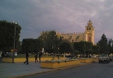
Highway at km 170 in the central west part of the state of Hidalgo. The town of Ixmiquilpan is noted for its parish church, Church of San Miguel Arcangel, which contains a large series of murals done in the 16th century by native artists depicting Eagle
and Jaguar warriors in battle, along with other pre-Hispanic imagery.
 The first ethnic group to settle in the Mezquital Valley in Hidalgo state were a group of Otomies, who called themselves Hñahñus. They named this area Zutcani or Zetcat, which means place of verdolagas or pigweed. They were well established here by the time the Toltecs arrived to establish the city of Tollan
. These Otomies would be subjugated by the Toltecs then later by the Aztec Empire. Both these peoples spoke Nahuatl
and renamed the area Itzmiquilpan (later spelled Ixmiquilpan), which means “place where the verdolagas cut like flint knives. Under the Aztecs, these Otomies were not just a tributary people but also provided soldiers as allies in the Aztecs’ many wars. This gave them a certain amount of autonomy within the Aztec Empire. This notion of autonomy would continue into the Colonial period when communities such as Orizabita and San Juanico called themselves “republics.”
After the Conquest, the first Spanish arrived here headed by Pedro Rodríguez de Escobar, who were sent by Pedro de Alvarado
as scouts. The Augustinian monks who accompanied these soldiers founded the town of Ixmiquilpan, with the founding of the church and monastery of San Miguel Arcangel in 1550. The town grew over time, and by the early 17th century, it was decided to build the first bridge over the Tula River
, to connect Ixmiquilpan with the newer settlement of Barrio de la Otra Banda, today Barrio de Progreso. The project was undertaken by Captain Miguel Cuevas y Dávales and inaugurated in 1655.
Another important church, the Chapel of Nuestra Señora del Carmen was built by Patricio Joseph Tovar. It was built in what was called the Tlazintla neighborhood, now called Del Carmen. Construction of the church betan in 1752 and completed in 1772.
In 1779, Diego Alarcón de Ocaña was named mayor of the town, who introduced a potable water system, among a number of other projects of social benefit. For this reason, one of the main roads is named after here, and there was a statue of him on the main plaza. This statue was destroyed by an earthquake.
During the Mexican War of Independence
, insurgent forces under Ignacio López Rayón
made camp here and also defeated royalist forces in the nearby village of Tamaleras, now called López Rayón. In 1854, a local uprising, especially in the communities of Orizabita and Remedios was caused by excessive taxes which Ixmiquilpan authorities levied. These were led by Sotero Lozano, who was called a bandit. This leader was most active in the towns of Actopan and Cardonal, his hometown.
Another bridge over the Tula River was constructed in 1912 in the Barrio Del Maye.
President Venustiano Carranza
came to Ixmiquilpan in 1918 to inaugurate the rail line between Pachuca
and here, along with the Nith train station. The rail line through here was planned by Englishman Richard Honey, who came to Ixmiquilpan with his family to settle. The rail line was supposed to run from Pachuca to Tampico
, Tamaulipas
but it was built only as far as this town. However, Honey did manage to built the “Iron Bridge” over the Tula River in the village of Tasquillo which became part of the Camino Real as well.
While here, he also signed a convention to construct a canal now called Debodhe to divert water from the Tula River for agricultural purposes. General Alvaro Obregon
also came here while campaigning for a second term as president of Mexico
. During the presidency of Lázaro Cárdenas
, who also visited Ixmiquilpan on several occasions, the Tecolote Dam as well as the El Morelos and El Moros Canals were built, to replace the old Debodhe canal. Later the Capula Dam would be built as well as a canal that brought drainage waters from the Valley of Mexico
, which was also used for irrigation purposes. At the end of the 1930s the irrigation capacity of the valley was expanded again with the Maye Dam and the Felipe Angels Dam.
In the 1940s the Mexico City/Laredo highway was built through Ixmiquilpan which gave the town more connection with the outside world. A short time later the municipal market
was inaugurated in 1942 to meet the needs of the growing community. This market was originally on the main plaza but was moved to the Jose Maria Morelos neighborhood in 1969.
In 1951, by presidential decree, the Patrimonio Indígena del Valle de Mezquital (Valley of Mezquital Indigenous Heritage) was created in Ixmiquilpan by President Miguel Alemán Valez and state governor D. Quintín Rueda Villagran. The primary function of this organization is to promote the economy and the education of the Otomies of this region. One of its first projects was to build the Justo Sierra Secondary School in the town. Prior to this school’s construction, youths had to travel to Pachuca or event Mexico City for a secondary education.
By 1969, many urbanization projects, such as the municipal market, paved streets and streetlights had been accomplished. Another project from this time was the remodeling of the main plaza and the installation of the Diana, the Huntress
fountain in the center of the plaza. From the 1940s to the 1960s the town of Ixmiquilpan improved its infrastructure considerably with the installation of the public health clinic, expansion of the main park, a sports center, a municipal library, the remodeling of the Hidalgo Theatre, the establishment of the Ñañhu or Otomi Cultural Museum and installation of radio and television broadcast. Not only did this improved the socioeconomic status of those living here, the population quintupled.
by Mexican Federal Highway 85
, it was an important commercial strategic spot even before the Spanish conquest. Its population is mainly Otomi
, regionally called Ñhañhu. According to town chronicler José Antonio Ramírez Guerrero, Ixmiquilpan has taken steps to participate in the Pueblos Mágicos programs, which are sponsored by the Mexican government's Tourism Secretary. The town qualifies for its history, surrounding landscapes and the Otomí culture that is strongly present here. However, a number of improvements are still needed in the town’s infrastructure, especially in the way of sanitation and services for tourists.
 After the arrival of Augustinian monks shortly after the Spanish Conquest of Mexico, this church and its now former monastery were built by Fray Andrés de la Mata de Barrios in 1550. The church is dedicated to the Archangel Michael and was built using Indian labor pressed into service by the monks. This church is typical of the fortress-style churches built by the Augustinians in the 16th century. The facade is Plateresque
style with paired columns and with a window in the choir area. The bell tower is annexed and joined with the facade. It has a crown and bell gable
s.
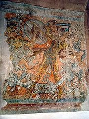
However, what makes the church fairly unique are its murals with overt pre-Hispanic themes. Imagery that is repeated here is that of holy war, with Eagle and Jaguar warriors as well as images associated with the sun and moon gods. The Jaguar and Eagle warriors were some of the armies that the Spanish fought during the Conquest, who wore resplendent apparel. Few explicit pictorial references to these warriors were permitted afterwards. The murals at Ixmiquilpan are an exception. The murals here appear in series of polychrome frescos, which have structure in a large and coherent way. Traditional monastic murals of that time where monochromatic and devoted to Biblical subjects. Some of these more traditional murals can be seen in the church’s sacristy.
The significance of the murals have been debated, especially since they are found so prominently in a Christian church of early in the colonial period. Mostly likely these images were at least partially reinterpreted with Christian themes. Many combine indigenous images with themes from the European Renaissance. The father sun figure in Otomí mythology, Zidada Hyadi (Venerable Sun) was identified with Jesus (Zidada Hesu) and the moon goddess (Zinänä) with the Virgin Mary As for the war images, The 1570s here were characterized by near-constant battles with the nomadic Chichimecas, which was finally ended with a decisive battle wonde by the Otomis. That battle was also views as a triumph of Christianity over paganism
.
Upon entering the church, one can see underneath the choir, fragments of murals showing Eagle and Jaguar warriors dialoguing, indicated by Aztec speech scrolls. Inside the nave is a large sequence of battle murals in enormous friezes that extend from under the choir long both sides. On the south wall, Eagle, Jaguar and Coyote warriors are dressed in animal skins, robes and feathered helmets, all fighting one another with obsidian
swords and other weapons. The scenes depict decapitations and the dragging of prisoners against a landscape rich in foliage. Along the north wall, these warriors battle supernatural creatures such as a centaur which wears a headdress of quetzal
feathers and figures of pregnant women emerging from acanthus buds.
This church was declared a national monument in 1933.
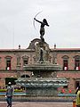 In the center of the main plaza is a fountain, which contains a sculpture of Diana, the Huntress. This sculpture was the original Diana that was created by Olabuibel in 1942 and placed on Paseo de la Reforma
in Mexico City. In 1944, a group known as the “League of Decency” headed by Soledad Orozco de Avila Camacho, wife of president Manuel Avila Camacho
, decided that the Diana statue, such was indecent due to the fact that it was nude. It was removed from Reforma and put in Chapultepec Park before it came to Ixmiquilpan and placed in the fountain there in 1970. The Diana statue that is currently in Mexico City is a second version cast by Olaguibel and placed in the same place in Mexico City.
trees marking the entrances. There used to be stone plaques that recorded the history of the bridges construction, and above one of them a statue of the Archangel Michael subduing the devil with his sword, but these have disappeared recently. It is part of a road that used to be called El Camino Real de Ixmiquilpan and is now known as Progreso Street. It was the Camino Real because it was the principle road connecting the towns of Tasquillo, Zimapan, Alfajayucan and Ixmiquilpan with the Bajio territory to the west. Until the construction of the Mexico City/Laredo highway, this was the major road of the area.
Aside from the San Miguel Church, the Chapel of Nuestra Señora del Carmen is one of the most important churches here. It has a pink stone facade, and inside there are tall wood altarpieces and large oil paintings. Its small atrium used to have a large number of cypress trees but these were cut down recently.
The Municipal Palace and the Hidalgo Theater next to it were built at the iniative of Mayor Marín Yánez, between 1906 and 1910 in preparation for the Centennial of Mexico’s Independence. A local story states that when the Palace was inaugurated, a small pot filled with gold coins was interred in one of the portals. In 1949, during the first remodeling of the building, this pot was found but no one knows what happened to the coins.
The Universidad Tecnológica del Valle de Mezquital is sponsored by the state of Hidalgo and located in a number of communities and based in Ixmiquilpan. Its mission is to provide technical and economically important skills to the people of the state as well as promote university-level studies in many areas.
had always been an important, solemn commemoration in the Church of the Archangel Michael, in recent years, a re-enactment of Good Friday
has been added, which is a procession from the Barrio of San Miguel to the church. Another important festival is that of the Holy Cross of Maye on the third of May. On this day descends the cross kept at the chapel on Deshitzo Mountain. This cross is the one that is brought up to the chapel on Deshitzo on 21 or 22 October in a procession that starts at the Maye Church and goes five km up the mountain to leave the cross and celebrate a Mass.
The Feast of the Santo Niño de Atocha
is celebrated in Barrio Progreso the last Sunday in January. It is one of the most representative celebrations of the municipality and draws pilgrims from other parts of the state and elsewhere. The festival lasts two or three days, depending on the economy and includes amusement rides, traditional dances, sporting and cultural events.
The Lord of Jalpan (Señor de Jalpan) has two dates associated with him. The first is a festival that is held on the 13th of June, which draws bands devoted to wind instruments, and has become an important economic contributor in recent years. The other event is a procession that has been held on the 7th of September since 1946. This is a very traditional procession with candles, flower-adorned arches, dancers, songs and fireworks. The procession begins at about 8pm and wanders the streets of Ixmiquilpan until about 2 in the morning.
A secular parade particular to Ixmiquilpan takes place on the 21 of March. All the schools participate in the event creating floats and then marching around the town, dancing and playing instruments.
The climate and topography of the municipal divide into two parts. The land is beautiful and many take hiking trips for fun since the climate is almost perfect. This is causing an increaing number of tourism to this particular area. Many buses departing from Mexico City arrive to this destination and visitors spend time in the so famaous water parks throughout the community. One well know park is El Parque Acuatico De Dios Padre. This particular park offers transportation, hotels, camping and services for tourists that come from Mexico City. Many immigrants that migrated to the U.S. in the 1980s as the result in shortages of farm labor in California are from this particular area. Now in their late 20's, many have now obtained a higher education in the U.S. and are now returnig to their homeland in Ixmiquilpan. This has let to new entreneurship in the area. Small businesses of tourism and hotels can now be found across the city. The southern portion is dry with green areas only where there is irrigation. It is relatively flat. The north in squarely in the Mezquital Valley and is considerably higher, wetter and more mountainous. A mountain ridge separates the two sections. The highest elevations are found at the La Palma, Thito, Muñeca, Guadril, Temboo, Dexitzo and Daxhie Mountains. These and other mountains have forests which contain pine, oak, walnut and a number of other trees. The dry areas contain vegetation such as mesquite
, nopal
, palms and other plants adapted to arid areas. Much of the agriculture in the municipality occurs in the relatively flat south which relies on irrigation due to the lack of rainfall. Main crops are corn, beans, animal feed and tomatoes. Livestock raised includes cattle, pigs, sheep, goats, turkeys and bees. There is some fishing in the north, where water is abundant, but it is mostly for auto-consumption.
 Almost a third of the population of the municipality still speaks an indigenous language, and this is almost exclusively Otomí
. This is especially true in the smaller communities such as San Alberto, located in one of the lower portions of the Mezquital Valley off the highway between Ixmiquilpan and El Progreso, near the Tula River. It is a village of about 700 people, all of whom speak Otomi and a number speak little or no Spanish. They are farmers, living off the harvests of corn, beans and other staples. It is a poor town, with roads in disrepair and no streetlights. While the village has been converting this fresh water and hot springs here into bathing pools to attract tourism, many of their young people go to the United States to work and send back money.ref name="ñañu">
The cuisine of this area is dependent on what is grown here. The pigweed which used to be the base of Ixmiquilpan’s Otomi name, is eaten with nopales and in other mixtures. Edible insects such as butterfly larvae, honey ants, nopal beetles, escamoles
, mequite, nopal and corn worms are all used here in tacos, roasted, in omelets and other ways. The maguey flower, called gualumbo, is sautéed with epazote
, onion and chile. Catfish and barbacoa
are also staples here.
The municipality contains a number of spas which take advantage of the streams and springs that are heated by the volcanic activity of the Trans-Mexican Volcanic Belt
which runs through here. Many of these waters have a high mineral content and are claimed to have curative powers. Some of these spas are Tephé, Te-Pathé, Dios Padre, Parque Ecoturistico EcoAlberto, Balenario Valle Paraíso, Pueblo Nuevo, Balneario Mague Blanco, El Dauthi and Puerta de Oeste. There is also a natural reserve located to the north of the town on State Highway 27, which exuberant vegetation, waterfalls and rock formations, where camping and other outdoor activities are possible.
While the majority of the municipality’s population (83%) are Catholic, other denominations have a definite presence, especially those called “evangelicals.” In the village of San Nicolás, there have been religious conflicts between traditional Catholics and evangelicals since 1991. In 2001, nine evangelical families were expelled from the town. Tensions rose again in 2006, when Catholics opposed the construction of an evangelical church in the area, and tried to tear down the building under construction. In the community of Cantinela, a number of Catholic religious images were found torched. Local and state authorities have had to intervene on a number of occasions.
Municipalities of Hidalgo
The Mexican state of Hidalgois made up of 84 municipalities :...
, in central-eastern Mexico
Mexico
The United Mexican States , commonly known as Mexico , is a federal constitutional republic in North America. It is bordered on the north by the United States; on the south and west by the Pacific Ocean; on the southeast by Guatemala, Belize, and the Caribbean Sea; and on the east by the Gulf of...
. It is located on the Mexico City
Mexico City
Mexico City is the Federal District , capital of Mexico and seat of the federal powers of the Mexican Union. It is a federal entity within Mexico which is not part of any one of the 31 Mexican states but belongs to the federation as a whole...
/Nuevo Laredo
Nuevo Laredo
Nuevo Laredo is a city located in the Municipality of Nuevo Laredo in the Mexican state of Tamaulipas. The city lies on the banks of the Río Grande, across from the United States city of Laredo, Texas. The 2010 census population of the city was 373,725. Nuevo Laredo is part of the Laredo-Nuevo...
Highway at km 170 in the central west part of the state of Hidalgo. The town of Ixmiquilpan is noted for its parish church, Church of San Miguel Arcangel, which contains a large series of murals done in the 16th century by native artists depicting Eagle
Eagle warrior
Eagle warriors or eagle knights were a special class of infantry soldier in the Aztec army, one of the two leading military orders in Aztec society. These military orders were made up of the bravest soldiers of noble birth and those who had taken the greatest number of prisoners in battle. Of...
and Jaguar warriors in battle, along with other pre-Hispanic imagery.
History
Tollan
Tollan, Tolan, or Tolán is a name used for the capital cities of two empires of Pre-Columbian Mesoamerica; first for Teotihuacan, and later for the Toltec capital, Tula-Hidalgo, both in Mexico...
. These Otomies would be subjugated by the Toltecs then later by the Aztec Empire. Both these peoples spoke Nahuatl
Nahuatl
Nahuatl is thought to mean "a good, clear sound" This language name has several spellings, among them náhuatl , Naoatl, Nauatl, Nahuatl, Nawatl. In a back formation from the name of the language, the ethnic group of Nahuatl speakers are called Nahua...
and renamed the area Itzmiquilpan (later spelled Ixmiquilpan), which means “place where the verdolagas cut like flint knives. Under the Aztecs, these Otomies were not just a tributary people but also provided soldiers as allies in the Aztecs’ many wars. This gave them a certain amount of autonomy within the Aztec Empire. This notion of autonomy would continue into the Colonial period when communities such as Orizabita and San Juanico called themselves “republics.”
After the Conquest, the first Spanish arrived here headed by Pedro Rodríguez de Escobar, who were sent by Pedro de Alvarado
Pedro de Alvarado
Pedro de Alvarado y Contreras was a Spanish conquistador and governor of Guatemala. He participated in the conquest of Cuba, in Juan de Grijalva's exploration of the coasts of Yucatan and the Gulf of Mexico, and in the conquest of Mexico led by Hernan Cortes...
as scouts. The Augustinian monks who accompanied these soldiers founded the town of Ixmiquilpan, with the founding of the church and monastery of San Miguel Arcangel in 1550. The town grew over time, and by the early 17th century, it was decided to build the first bridge over the Tula River
Tula River
Rio Tula is a river in Hidalgo state in central Mexico. It runs through the ancient town of Tula....
, to connect Ixmiquilpan with the newer settlement of Barrio de la Otra Banda, today Barrio de Progreso. The project was undertaken by Captain Miguel Cuevas y Dávales and inaugurated in 1655.
Another important church, the Chapel of Nuestra Señora del Carmen was built by Patricio Joseph Tovar. It was built in what was called the Tlazintla neighborhood, now called Del Carmen. Construction of the church betan in 1752 and completed in 1772.
In 1779, Diego Alarcón de Ocaña was named mayor of the town, who introduced a potable water system, among a number of other projects of social benefit. For this reason, one of the main roads is named after here, and there was a statue of him on the main plaza. This statue was destroyed by an earthquake.
During the Mexican War of Independence
Mexican War of Independence
The Mexican War of Independence was an armed conflict between the people of Mexico and the Spanish colonial authorities which started on 16 September 1810. The movement, which became known as the Mexican War of Independence, was led by Mexican-born Spaniards, Mestizos and Amerindians who sought...
, insurgent forces under Ignacio López Rayón
Ignacio López Rayón
Ignacio López Rayón led the revolutionary government of his country after Miguel Hidalgo's death, during the first years of the Mexican War of Independence....
made camp here and also defeated royalist forces in the nearby village of Tamaleras, now called López Rayón. In 1854, a local uprising, especially in the communities of Orizabita and Remedios was caused by excessive taxes which Ixmiquilpan authorities levied. These were led by Sotero Lozano, who was called a bandit. This leader was most active in the towns of Actopan and Cardonal, his hometown.
Another bridge over the Tula River was constructed in 1912 in the Barrio Del Maye.
President Venustiano Carranza
Venustiano Carranza
Venustiano Carranza de la Garza, was one of the leaders of the Mexican Revolution. He ultimately became President of Mexico following the overthrow of the dictatorial Huerta regime in the summer of 1914 and during his administration the current constitution of Mexico was drafted...
came to Ixmiquilpan in 1918 to inaugurate the rail line between Pachuca
Pachuca
Pachuca, formally Pachuca de Soto is the capital of the Mexican state of Hidalgo. It is located in the south-central part of the state. Pachuca de Soto is also the name of the municipality of which the city serves as municipal seat...
and here, along with the Nith train station. The rail line through here was planned by Englishman Richard Honey, who came to Ixmiquilpan with his family to settle. The rail line was supposed to run from Pachuca to Tampico
Tampico
Tampico is a city and port in the state of Tamaulipas, in the country of Mexico. It is located in the southeastern part of the state, directly north across the border from Veracruz. Tampico is the third largest city in Tamaulipas, and counts with a population of 309,003. The Metropolitan area of...
, Tamaulipas
Tamaulipas
Tamaulipas officially Estado Libre y Soberano de Tamaulipas is one of the 31 states which, with the Federal District, comprise the 32 Federal Entities of Mexico. It is divided in 43 municipalities and its capital city is Ciudad Victoria. The capital city was named after Guadalupe Victoria, the...
but it was built only as far as this town. However, Honey did manage to built the “Iron Bridge” over the Tula River in the village of Tasquillo which became part of the Camino Real as well.
While here, he also signed a convention to construct a canal now called Debodhe to divert water from the Tula River for agricultural purposes. General Alvaro Obregon
Álvaro Obregón
General Álvaro Obregón Salido was the President of Mexico from 1920 to 1924. He was assassinated in 1928, shortly after winning election to another presidential term....
also came here while campaigning for a second term as president of Mexico
President of Mexico
The President of the United Mexican States is the head of state and government of Mexico. Under the Constitution, the president is also the Supreme Commander of the Mexican armed forces...
. During the presidency of Lázaro Cárdenas
Lázaro Cárdenas
Lázaro Cárdenas del Río was President of Mexico from 1934 to 1940.-Early life:Lázaro Cárdenas was born on May 21, 1895 in a lower-middle class family in the village of Jiquilpan, Michoacán. He supported his family from age 16 after the death of his father...
, who also visited Ixmiquilpan on several occasions, the Tecolote Dam as well as the El Morelos and El Moros Canals were built, to replace the old Debodhe canal. Later the Capula Dam would be built as well as a canal that brought drainage waters from the Valley of Mexico
Valley of Mexico
The Valley of Mexico is a highlands plateau in central Mexico roughly coterminous with the present-day Distrito Federal and the eastern half of the State of Mexico. Surrounded by mountains and volcanoes, the Valley of Mexico was a centre for several pre-Columbian civilizations, including...
, which was also used for irrigation purposes. At the end of the 1930s the irrigation capacity of the valley was expanded again with the Maye Dam and the Felipe Angels Dam.
In the 1940s the Mexico City/Laredo highway was built through Ixmiquilpan which gave the town more connection with the outside world. A short time later the municipal market
Traditional fixed markets in Mexico
Traditional fixed markets in Mexico go by a variety of names such as "mercados públicos" , "mercados municipales" or even more often simply "mercados"...
was inaugurated in 1942 to meet the needs of the growing community. This market was originally on the main plaza but was moved to the Jose Maria Morelos neighborhood in 1969.
In 1951, by presidential decree, the Patrimonio Indígena del Valle de Mezquital (Valley of Mezquital Indigenous Heritage) was created in Ixmiquilpan by President Miguel Alemán Valez and state governor D. Quintín Rueda Villagran. The primary function of this organization is to promote the economy and the education of the Otomies of this region. One of its first projects was to build the Justo Sierra Secondary School in the town. Prior to this school’s construction, youths had to travel to Pachuca or event Mexico City for a secondary education.
By 1969, many urbanization projects, such as the municipal market, paved streets and streetlights had been accomplished. Another project from this time was the remodeling of the main plaza and the installation of the Diana, the Huntress
Diana (mythology)
In Roman mythology, Diana was the goddess of the hunt and moon and birthing, being associated with wild animals and woodland, and having the power to talk to and control animals. She was equated with the Greek goddess Artemis, though she had an independent origin in Italy...
fountain in the center of the plaza. From the 1940s to the 1960s the town of Ixmiquilpan improved its infrastructure considerably with the installation of the public health clinic, expansion of the main park, a sports center, a municipal library, the remodeling of the Hidalgo Theatre, the establishment of the Ñañhu or Otomi Cultural Museum and installation of radio and television broadcast. Not only did this improved the socioeconomic status of those living here, the population quintupled.
The town
It is considered the heart of the Mezquital Valley of Mexico. Located 158 km. from Mexico CityMexico City
Mexico City is the Federal District , capital of Mexico and seat of the federal powers of the Mexican Union. It is a federal entity within Mexico which is not part of any one of the 31 Mexican states but belongs to the federation as a whole...
by Mexican Federal Highway 85
Mexican Federal Highway 85
Mexico's Federal Highway 85 connects Mexico City with the U.S. border at Nuevo Laredo, Tamaulipas. It is the original route of the Inter-American Highway. Highway 85 runs through Monterrey, Nuevo León; Ciudad Victoria, Tamaulipas; Ciudad Valles, San Luis Potosí; and Pachuca, Hidalgo...
, it was an important commercial strategic spot even before the Spanish conquest. Its population is mainly Otomi
Otomi people
The Otomi people . Smaller Otomi populations exist in the states of Puebla, Mexico, Tlaxcala, Michoacán and Guanajuato. The Otomi language belonging to the Oto-Pamean branch of the Oto-Manguean language family is spoken in many different varieties some of which are not mutually intelligible.One of...
, regionally called Ñhañhu. According to town chronicler José Antonio Ramírez Guerrero, Ixmiquilpan has taken steps to participate in the Pueblos Mágicos programs, which are sponsored by the Mexican government's Tourism Secretary. The town qualifies for its history, surrounding landscapes and the Otomí culture that is strongly present here. However, a number of improvements are still needed in the town’s infrastructure, especially in the way of sanitation and services for tourists.
Church of San Miguel Arcangel
Plateresque
Plateresque, meaning "in the manner of a silversmith" , was an artistic movement, especially architectural, traditionally held to be exclusive to Spain and its territories, which appeared between the late Gothic and early Renaissance in the late 15th century, and spread over the next two centuries...
style with paired columns and with a window in the choir area. The bell tower is annexed and joined with the facade. It has a crown and bell gable
Gable
A gable is the generally triangular portion of a wall between the edges of a sloping roof. The shape of the gable and how it is detailed depends on the structural system being used and aesthetic concerns. Thus the type of roof enclosing the volume dictates the shape of the gable...
s.
However, what makes the church fairly unique are its murals with overt pre-Hispanic themes. Imagery that is repeated here is that of holy war, with Eagle and Jaguar warriors as well as images associated with the sun and moon gods. The Jaguar and Eagle warriors were some of the armies that the Spanish fought during the Conquest, who wore resplendent apparel. Few explicit pictorial references to these warriors were permitted afterwards. The murals at Ixmiquilpan are an exception. The murals here appear in series of polychrome frescos, which have structure in a large and coherent way. Traditional monastic murals of that time where monochromatic and devoted to Biblical subjects. Some of these more traditional murals can be seen in the church’s sacristy.
The significance of the murals have been debated, especially since they are found so prominently in a Christian church of early in the colonial period. Mostly likely these images were at least partially reinterpreted with Christian themes. Many combine indigenous images with themes from the European Renaissance. The father sun figure in Otomí mythology, Zidada Hyadi (Venerable Sun) was identified with Jesus (Zidada Hesu) and the moon goddess (Zinänä) with the Virgin Mary As for the war images, The 1570s here were characterized by near-constant battles with the nomadic Chichimecas, which was finally ended with a decisive battle wonde by the Otomis. That battle was also views as a triumph of Christianity over paganism
Paganism
Paganism is a blanket term, typically used to refer to non-Abrahamic, indigenous polytheistic religious traditions....
.
Upon entering the church, one can see underneath the choir, fragments of murals showing Eagle and Jaguar warriors dialoguing, indicated by Aztec speech scrolls. Inside the nave is a large sequence of battle murals in enormous friezes that extend from under the choir long both sides. On the south wall, Eagle, Jaguar and Coyote warriors are dressed in animal skins, robes and feathered helmets, all fighting one another with obsidian
Obsidian use in Mesoamerica
Obsidian is a naturally formed volcanic glass that was an important part of the material culture of Pre-Columbian Mesoamerica. Obsidian was a highly integrated part of daily and ritual life, and its widespread and varied use may be a significant contributor to Mesoamerica's lack of metallurgy...
swords and other weapons. The scenes depict decapitations and the dragging of prisoners against a landscape rich in foliage. Along the north wall, these warriors battle supernatural creatures such as a centaur which wears a headdress of quetzal
Quetzal
Quetzals are strikingly colored birds in the trogon family . They are found in forests and woodlands, especially in humid highlands, with the five species from the genus Pharomachrus being exclusively Neotropical, while the single Euptilotis species is almost entirely restricted to western Mexico...
feathers and figures of pregnant women emerging from acanthus buds.
This church was declared a national monument in 1933.
The Diana fountain
Paseo de la Reforma
Paseo de la Reforma is a wide avenue that runs in a straight line, cutting diagonally across Mexico City. It was designed by Ferdinand von Rosenzweig in the 1860s and modeled after the great boulevards of Europe, such as Vienna's Ringstrasse or the Champs-Élysées in Paris...
in Mexico City. In 1944, a group known as the “League of Decency” headed by Soledad Orozco de Avila Camacho, wife of president Manuel Avila Camacho
Manuel Ávila Camacho
Manuel Ávila Camacho served as the President of Mexico from 1940 to 1946.Manuel Ávila was born in the city of Teziutlán, a small town in Puebla, to middle-class parents, Manuel Ávila Castillo and Eufrosina Camacho Bello. He had several siblings, among them sister María Jovita Ávila Camacho and...
, decided that the Diana statue, such was indecent due to the fact that it was nude. It was removed from Reforma and put in Chapultepec Park before it came to Ixmiquilpan and placed in the fountain there in 1970. The Diana statue that is currently in Mexico City is a second version cast by Olaguibel and placed in the same place in Mexico City.
Other sites of interest
The Bridge of San Miguel or La Otra Banda was the first built here in the 17th century. It was built of stone with large arches, and on each side of the river there are Moctezuma cypressTaxodium mucronatum
Taxodium mucronatum, also known as Montezuma Cypress, Sabino, or Ahuehuete is a species of Taxodium native to much of Mexico , and also the Rio Grande Valley in southernmost Texas, USA as well as Huehuetenango Department in Guatemala...
trees marking the entrances. There used to be stone plaques that recorded the history of the bridges construction, and above one of them a statue of the Archangel Michael subduing the devil with his sword, but these have disappeared recently. It is part of a road that used to be called El Camino Real de Ixmiquilpan and is now known as Progreso Street. It was the Camino Real because it was the principle road connecting the towns of Tasquillo, Zimapan, Alfajayucan and Ixmiquilpan with the Bajio territory to the west. Until the construction of the Mexico City/Laredo highway, this was the major road of the area.
Aside from the San Miguel Church, the Chapel of Nuestra Señora del Carmen is one of the most important churches here. It has a pink stone facade, and inside there are tall wood altarpieces and large oil paintings. Its small atrium used to have a large number of cypress trees but these were cut down recently.
The Municipal Palace and the Hidalgo Theater next to it were built at the iniative of Mayor Marín Yánez, between 1906 and 1910 in preparation for the Centennial of Mexico’s Independence. A local story states that when the Palace was inaugurated, a small pot filled with gold coins was interred in one of the portals. In 1949, during the first remodeling of the building, this pot was found but no one knows what happened to the coins.
The Universidad Tecnológica del Valle de Mezquital is sponsored by the state of Hidalgo and located in a number of communities and based in Ixmiquilpan. Its mission is to provide technical and economically important skills to the people of the state as well as promote university-level studies in many areas.
Festivals
While Holy WeekHoly Week
Holy Week in Christianity is the last week of Lent and the week before Easter...
had always been an important, solemn commemoration in the Church of the Archangel Michael, in recent years, a re-enactment of Good Friday
Good Friday
Good Friday , is a religious holiday observed primarily by Christians commemorating the crucifixion of Jesus Christ and his death at Calvary. The holiday is observed during Holy Week as part of the Paschal Triduum on the Friday preceding Easter Sunday, and may coincide with the Jewish observance of...
has been added, which is a procession from the Barrio of San Miguel to the church. Another important festival is that of the Holy Cross of Maye on the third of May. On this day descends the cross kept at the chapel on Deshitzo Mountain. This cross is the one that is brought up to the chapel on Deshitzo on 21 or 22 October in a procession that starts at the Maye Church and goes five km up the mountain to leave the cross and celebrate a Mass.
The Feast of the Santo Niño de Atocha
Santo Niño de Atocha
The Santo Niño de Atocha is a Roman Catholic depiction of the Child Jesus and is popular in the Hispanic cultures of Spain, Mexico, Philippines and the southwestern United States, especially New Mexico.-History:...
is celebrated in Barrio Progreso the last Sunday in January. It is one of the most representative celebrations of the municipality and draws pilgrims from other parts of the state and elsewhere. The festival lasts two or three days, depending on the economy and includes amusement rides, traditional dances, sporting and cultural events.
The Lord of Jalpan (Señor de Jalpan) has two dates associated with him. The first is a festival that is held on the 13th of June, which draws bands devoted to wind instruments, and has become an important economic contributor in recent years. The other event is a procession that has been held on the 7th of September since 1946. This is a very traditional procession with candles, flower-adorned arches, dancers, songs and fireworks. The procession begins at about 8pm and wanders the streets of Ixmiquilpan until about 2 in the morning.
A secular parade particular to Ixmiquilpan takes place on the 21 of March. All the schools participate in the event creating floats and then marching around the town, dancing and playing instruments.
The municipality
The municipality of Ixmiquilpan consists of the town of Ixmiquilpan and 145 other recognized communities, which cover an area of 565.3 km². The largest communities outside of the seat are Panales, el Tephé, Maguey Blanco, Orizabita, el Alberto, Dios Padre, Julián Villagrán and Tatzadhó. The municipality borders with the municipalities of Zimapán, Nicolás Flores, Cardonal, Santiago de Anaya, San Salvador, Chilcuautla and Tasquillo. The total population of the municipality is 73,903, with 24,341, or almost a third speaking an indigenous language.The climate and topography of the municipal divide into two parts. The land is beautiful and many take hiking trips for fun since the climate is almost perfect. This is causing an increaing number of tourism to this particular area. Many buses departing from Mexico City arrive to this destination and visitors spend time in the so famaous water parks throughout the community. One well know park is El Parque Acuatico De Dios Padre. This particular park offers transportation, hotels, camping and services for tourists that come from Mexico City. Many immigrants that migrated to the U.S. in the 1980s as the result in shortages of farm labor in California are from this particular area. Now in their late 20's, many have now obtained a higher education in the U.S. and are now returnig to their homeland in Ixmiquilpan. This has let to new entreneurship in the area. Small businesses of tourism and hotels can now be found across the city. The southern portion is dry with green areas only where there is irrigation. It is relatively flat. The north in squarely in the Mezquital Valley and is considerably higher, wetter and more mountainous. A mountain ridge separates the two sections. The highest elevations are found at the La Palma, Thito, Muñeca, Guadril, Temboo, Dexitzo and Daxhie Mountains. These and other mountains have forests which contain pine, oak, walnut and a number of other trees. The dry areas contain vegetation such as mesquite
Mesquite
Mesquite is a leguminous plant of the Prosopis genus found in northern Mexico through the Sonoran Desert and Chihuahuan Deserts, and up into the Southwestern United States as far north as southern Kansas, west to the Colorado Desert in California,and east to the eastern fifth of Texas, where...
, nopal
Nopal
Nopales are a vegetable made from the young cladode segments of prickly pear, carefully peeled to remove the spines. These fleshy pads are flat and about hand-sized. They can be purple or green...
, palms and other plants adapted to arid areas. Much of the agriculture in the municipality occurs in the relatively flat south which relies on irrigation due to the lack of rainfall. Main crops are corn, beans, animal feed and tomatoes. Livestock raised includes cattle, pigs, sheep, goats, turkeys and bees. There is some fishing in the north, where water is abundant, but it is mostly for auto-consumption.
Otomi language
Otomi is an Oto-Manguean language and one of the indigenous languages of Mexico, spoken by approximately 240,000 indigenous Otomi people in the central altiplano region of Mexico. The language is spoken in many different dialects, some of which are not mutually intelligible, therefore it is in...
. This is especially true in the smaller communities such as San Alberto, located in one of the lower portions of the Mezquital Valley off the highway between Ixmiquilpan and El Progreso, near the Tula River. It is a village of about 700 people, all of whom speak Otomi and a number speak little or no Spanish. They are farmers, living off the harvests of corn, beans and other staples. It is a poor town, with roads in disrepair and no streetlights. While the village has been converting this fresh water and hot springs here into bathing pools to attract tourism, many of their young people go to the United States to work and send back money.ref name="ñañu">
The cuisine of this area is dependent on what is grown here. The pigweed which used to be the base of Ixmiquilpan’s Otomi name, is eaten with nopales and in other mixtures. Edible insects such as butterfly larvae, honey ants, nopal beetles, escamoles
Escamoles
Escamoles are the larvae of ants of the genus Liometopum, harvested from the roots of the agave or maguey plant in Mexico. In some forms of Mexican cuisine, escamoles are considered a delicacy and are sometimes referred to as "insect caviar"...
, mequite, nopal and corn worms are all used here in tacos, roasted, in omelets and other ways. The maguey flower, called gualumbo, is sautéed with epazote
Epazote
Epazote, wormseed, Jesuit's tea, Mexican tea, Paico or Herba Sancti Mariæ is an herb native to Central America, South America, and southern Mexico....
, onion and chile. Catfish and barbacoa
Barbacoa
Barbacoa is a form of cooking meat that originated in the Caribbean with the Taíno people, from which the term "barbecue" derives. In contemporary Mexico it generally refers to meats or a whole sheep slow-cooked over an open fire, or more traditionally, in a hole dug in the ground covered with...
are also staples here.
The municipality contains a number of spas which take advantage of the streams and springs that are heated by the volcanic activity of the Trans-Mexican Volcanic Belt
Trans-Mexican volcanic belt
The Trans-Mexican Volcanic Belt also known as the Transvolcanic Belt and locally as the Sierra Nevada , is a volcanic belt that extends 900 km from west to east across central-southern Mexico...
which runs through here. Many of these waters have a high mineral content and are claimed to have curative powers. Some of these spas are Tephé, Te-Pathé, Dios Padre, Parque Ecoturistico EcoAlberto, Balenario Valle Paraíso, Pueblo Nuevo, Balneario Mague Blanco, El Dauthi and Puerta de Oeste. There is also a natural reserve located to the north of the town on State Highway 27, which exuberant vegetation, waterfalls and rock formations, where camping and other outdoor activities are possible.
While the majority of the municipality’s population (83%) are Catholic, other denominations have a definite presence, especially those called “evangelicals.” In the village of San Nicolás, there have been religious conflicts between traditional Catholics and evangelicals since 1991. In 2001, nine evangelical families were expelled from the town. Tensions rose again in 2006, when Catholics opposed the construction of an evangelical church in the area, and tried to tear down the building under construction. In the community of Cantinela, a number of Catholic religious images were found torched. Local and state authorities have had to intervene on a number of occasions.