
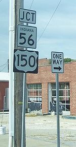
Indiana State Road 56
Encyclopedia
State Road 56 in the U.S. state
of Indiana
is a route that travels the south central part of the state from west to east.
 The western terminus of SR 56 is near Hazleton
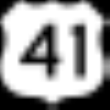
at U.S. Route 41
. SR 56 heads northeast to Hazleton. After Hazleton SR 56 turns southeast then back northeast, until State Road 65
(SR 65). Where SR 56 heads east towards Petersburg
, in Petersburg SR 56 is Concurrenct
with State Road 57
(SR 57), until the intersection
with State Road 61
(SR 61). SR 56 leaves Petersburg concurrent with SR 61 heading south, until SR 56 turns east. South of Otwell
SR 56 has an intersection with State Road 257
. SR 56 enters Jasper
on the west side and then has an intersection with U.S. Route 231, the two routes are concurrent until they leave Jasper on the north side of town. North of Jasper SR 56 turns east towards Paoli
passing through French Lick
. East of Paoli SR 56 heads towards Salem
passing through an intersection with State Road 337
. SR 56 and State Road 60
have a concurrency from the west side of Salem to downtown Salem. SR 56 leaves Salem heading northeast, then turning east near the southern terminus of State Road 39
(SR 39). After SR 39, SR 56 passing over Interstate 65
(I-65). Then SR 56 enters Scottsburg
where SR 56 has an intersection with U.S. Route 31. After leaving Scottsburg, SR 56 has a concurrency with State Road 203
and State Road 3
. Then SR 56 heads toward Hanover
where SR 56 and State Road 62
(SR 62) has a concurrency. East of Hanover SR 62 turns north and SR 56 heads east. East of the intersection with SR 62, SR 56 has an intersection with State Road 256
(SR 256). Then SR 56 enters Madison
where SR 56 has an intersection with the southern terminus of State Road 7
and a concurrency with U.S. Route 421
. East of Madison SR 56 parallels the Ohio River
. Then in Vevay
SR 56 has an intersection with the southern terminus of State Road 129
and the western terminus of State Road 156
(SR 156). After Vevay SR 56 heads north-northeast toward Aurora
passing through intersection with State Road 250
, SR 156, and State Road 262
, passing through the town of Rising Sun
. The northern terminus SR 56 is at an intersection with U.S. Route 50
and State Road 350
.
takes. In 1930 the east terminus of SR 56 was Lawrenceburg
at U.S. Route 52, this route is now part of State Road 1
.
U.S. state
A U.S. state is any one of the 50 federated states of the United States of America that share sovereignty with the federal government. Because of this shared sovereignty, an American is a citizen both of the federal entity and of his or her state of domicile. Four states use the official title of...
of Indiana
Indiana
Indiana is a US state, admitted to the United States as the 19th on December 11, 1816. It is located in the Midwestern United States and Great Lakes Region. With 6,483,802 residents, the state is ranked 15th in population and 16th in population density. Indiana is ranked 38th in land area and is...
is a route that travels the south central part of the state from west to east.
Route description
Hazleton, Indiana
Hazleton is a town in White River Township, Gibson County, Indiana, United States. The population was 263 at the 2010 census.- History :Hazleton is the second oldest town in Gibson county after Princeton. It was named in honor of Gervas Hazleton, the second settler in the county to permanently...
at U.S. Route 41
U.S. Route 41 in Indiana
In the U.S. state of Indiana, U.S. Route 41 is a north–south highway that is parallel to the Illinois state line. It enters the state south of Evansville. North of Evansville, it becomes a 4-Lane divided highway passing around Vincennes and traveling North to Terre Haute. In Terre Haute, it...
. SR 56 heads northeast to Hazleton. After Hazleton SR 56 turns southeast then back northeast, until State Road 65
Indiana State Road 65
State Road 65 crosses in four counties in the southwest portion of the U.S. State of Indiana.-Route description:State Road 65 begins at State Road 66 west of Evansville. It arcs to the northwest to the town of Cynthiana and State Road 68, then proceeds north through Owensville to State Road 64...
(SR 65). Where SR 56 heads east towards Petersburg
Petersburg, Indiana
Petersburg is a city in Washington Township, Pike County, Indiana, United States. The population was 2,383 at the 2010 census. The city is the county seat of Pike County.Petersburg is part of the Jasper Micropolitan Statistical Area.-Geography:...
, in Petersburg SR 56 is Concurrenct
Concurrency (road)
A concurrency, overlap, or coincidence in a road network is an instance of one physical road bearing two or more different highway, motorway, or other route numbers...
with State Road 57
Indiana State Road 57
State Road 57 in the U.S. State of Indiana is a north–south, largely two-lane road in the southwestern portion of the state.-Route description:...
(SR 57), until the intersection
Intersection (road)
An intersection is a road junction where two or more roads either meet or cross at grade . An intersection may be 3-way - a T junction or fork, 4-way - a crossroads, or 5-way or more...
with State Road 61
Indiana State Road 61
State Road 61 is a north–south route that runs through portions of three counties in the southwest part of the U.S. State of Indiana.-Route description:...
(SR 61). SR 56 leaves Petersburg concurrent with SR 61 heading south, until SR 56 turns east. South of Otwell
Otwell, Indiana
Otwell is an unincorporated town in Jefferson Township, Pike County, Indiana, USA. It has a population of 434 as of the 2010 census.-Geography:...
SR 56 has an intersection with State Road 257
Indiana State Road 257
State Road 257 is a 31-mile route in Daviess and Pike counties in the U.S. State of Indiana.-Route description:State Road 257 begins in the small town of Stendal. It winds north to pass through Pikeville, Velpen and Otwell. It terminates in Washington....
. SR 56 enters Jasper
Jasper, Indiana
- Strassenfest :The Jasper Strassenfest is a four-day event held annually during the first weekend in August. The "Fest" is a celebration between Jasper and its German sister-city Pfaffenweiler, a small village in southwest Germany. Many citizens of Pfaffenweiler travel to Jasper around this time...
on the west side and then has an intersection with U.S. Route 231, the two routes are concurrent until they leave Jasper on the north side of town. North of Jasper SR 56 turns east towards Paoli
Paoli, Indiana
Paoli is a town in Paoli Township, Orange County, Indiana, United States. The population was 3,844 at the 2000 census. The town is the county seat of Orange County.-History:...
passing through French Lick
French Lick, Indiana
French Lick is a town in French Lick Township, Orange County, Indiana, United States. The population was 1,807 at the 2010 census. In early 2006 the French Lick Resort Casino, the state's tenth casino in the modern legalized era, opened drawing national attention to the small town.- History :French...
. East of Paoli SR 56 heads towards Salem
Salem, Indiana
Salem is a city in Washington Township, Washington County, Indiana, United States. Salem serves as the county seat, and its downtown area is on the National Register of Historic Places...
passing through an intersection with State Road 337
Indiana State Road 337
State Road 337 in the U.S. State of Indiana is divided into a northern section and a southern section.-Southern section:The southern section is about long. Starting at State Road 64 in Depauw it runs along rolling hills toward Corydon. The Harrison County Hospital is located on the stretch next to...
. SR 56 and State Road 60
Indiana State Road 60
State Road 60 in the U.S. State of Indiana is a mostly rural, two-lane highway in the southeastern portion of the state, covering a distance of about .-Route description:...
have a concurrency from the west side of Salem to downtown Salem. SR 56 leaves Salem heading northeast, then turning east near the southern terminus of State Road 39
Indiana State Road 39
State Road 39 in the U.S. State of Indiana is the name of two distinct north–south highways in the state of Indiana.-Southern section:Located in south-central Indiana, the shorter southern section of State Road 39 begins at State Road 56 west of Scottsburg. It runs north and passes through...
(SR 39). After SR 39, SR 56 passing over Interstate 65
Interstate 65 in Indiana
In the U.S. state of Indiana, Interstate 65 traverses the state from south to north. The Indiana portion begins near Louisville, Kentucky and travels north, passing through Columbus, Indianapolis, Lafayette. Interstate 65 terminates near Gary on the Indiana Toll Road. Interstate 65 covers 261.27...
(I-65). Then SR 56 enters Scottsburg
Scottsburg, Indiana
Scottsburg is a city in Vienna Township, Scott County, Indiana, United States, about north of Louisville, Kentucky. The population was 6,747 at the 2010 census. The city is the county seat of Scott County. As of 2010, William H...
where SR 56 has an intersection with U.S. Route 31. After leaving Scottsburg, SR 56 has a concurrency with State Road 203
Indiana State Road 203
State Road 203 is a 14-mile north–south highway in the U.S. state of Indiana that runs mostly in Scott County.-Route description:At the south end, State Road 203 begins just within Clark County at its parent route State Road 3 and passes north through the town of Lexington...
and State Road 3
Indiana State Road 3
State Road 3 in the U.S. State of Indiana is a discontinuous state road running through east central Indiana from near the Michigan state line to near the Ohio River...
. Then SR 56 heads toward Hanover
Hanover, Indiana
Hanover is a town in Hanover Township, Jefferson County, Indiana, along the Ohio River. The population was 3,546 at the 2010 census. Hanover is the home of Hanover College, a small Presbyterian liberal arts college. Hanover is also the home of Southwestern High School...
where SR 56 and State Road 62
Indiana State Road 62
State Road 62 in the U.S. State of Indiana is an east–west route that runs from the Illinois state line in the southwest corner of Indiana to the Louisville, Kentucky area, then northeast toward the Cincinnati, Ohio area.-Route description:...
(SR 62) has a concurrency. East of Hanover SR 62 turns north and SR 56 heads east. East of the intersection with SR 62, SR 56 has an intersection with State Road 256
Indiana State Road 256
State Road 256 in the U.S. State of Indiana runs mostly through Scott and Jefferson counties, with short portions in Jackson and Washington counties. The western terminus is Indiana 39. The eastern terminus is Indiana 56 near Madison....
(SR 256). Then SR 56 enters Madison
Madison, Indiana
As of the census of 2000, there were 12,004 people, 5,092 households, and 3,085 families residing in the city. The population density was 1,402.9 people per square mile . There were 5,597 housing units at an average density of 654.1 per square mile...
where SR 56 has an intersection with the southern terminus of State Road 7
Indiana State Road 7
State Road 7 in the U.S. State of Indiana is located in southeast Indiana. It runs from northwest-to-southeast connecting the cities of Columbus and Madison.-Route description:...
and a concurrency with U.S. Route 421
U.S. Route 421 in Indiana
U.S. Route 421 enters Indiana from Kentucky, proceeding northwest to Indianapolis, joining Interstate 465, then continuing northwest to Michigan City....
. East of Madison SR 56 parallels the Ohio River
Ohio River
The Ohio River is the largest tributary, by volume, of the Mississippi River. At the confluence, the Ohio is even bigger than the Mississippi and, thus, is hydrologically the main stream of the whole river system, including the Allegheny River further upstream...
. Then in Vevay
Vevay, Indiana
Vevay is a town in and the county seat of Jefferson Township, Switzerland County, Indiana, United States, along the Ohio River. The population was 1,683 at the 2010 census.-History:...
SR 56 has an intersection with the southern terminus of State Road 129
Indiana State Road 129
State Road 129 is a north–south road in the southeastern part of the U.S. state of Indiana. It traverses Switzerland and Ripley counties connecting Vevay to Batesville.-Route description:...
and the western terminus of State Road 156
Indiana State Road 156
State Road 156 in the U.S. State of Indiana is part of the Ohio River Scenic Route in Switzerland and Ohio counties. It skirts the Ohio River, always staying within a mile of the shore throughout its .-Route description:...
(SR 156). After Vevay SR 56 heads north-northeast toward Aurora
Aurora, Indiana
Aurora is a city in Lawrenceburg and Center townships of Dearborn County, Indiana, United States, along the Ohio River. The population was 3,965 at the 2000 census.-Geography:Aurora is located at ....
passing through intersection with State Road 250
Indiana State Road 250
State Road 250 in the U.S. State of Indiana is a secondary route that runs from U.S. Route 50 in Brownstown eastward toward the Ohio River at State Road 156 in Patriot in southeast Indiana. Towns include Uniontown, Paris Crossing, Canaan, and East Enterprise...
, SR 156, and State Road 262
Indiana State Road 262
State Road 262 is a short, highway in the southeastern portion of the U.S. state of Indiana.-Route description:State Road 262 begins at U.S. Route 50 near Dillsboro in Dearborn County. Going south, it crosses State Road 62 after only a few hundred feet, then runs southeast. After a few miles, it...
, passing through the town of Rising Sun
Rising Sun, Indiana
Rising Sun is a city in Randolph Township, Ohio County, Indiana, along the Ohio River. The population was 2,304 at the 2010 census. The city is the county seat of Ohio County.-History:...
. The northern terminus SR 56 is at an intersection with U.S. Route 50
U.S. Route 50 in Indiana
In the U.S. state of Indiana, U.S. Route 50 is a major east–west route. It enters Indiana from Illinois and leaves Indiana into Ohio.- Route description :...
and State Road 350
Indiana State Road 350
State Road 350 in the U.S. state of Indiana is an east–west state highway in the southeastern corner of Indiana. The road's western terminus is at U.S. Route 421 in Osgood. Its eastern terminus is at U.S. Route 50 in Aurora.-Route description:...
.
History
In the western part of Indiana SR 56 originally followed the same routing at current State Road 64Indiana State Road 64
State Road 64 in the U.S. State of Indiana is an east–west highway that crosses most of the southern portion of the state, covering a distance of about .-Route description:...
takes. In 1930 the east terminus of SR 56 was Lawrenceburg
Lawrenceburg, Indiana
Lawrenceburg is a city in Dearborn County, Indiana, United States. The population was 5,042 at the 2010 census. The city is the county seat of Dearborn County...
at U.S. Route 52, this route is now part of State Road 1
Indiana State Road 1
State Road 1 is a north–south state highway in the eastern portion of the U.S. state of Indiana. Its southern terminus is at U.S. Highway 50 in east-central Dearborn County, just east of Lawrenceburg. Its northern terminus is at U.S...
.