
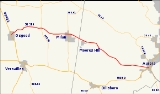
Indiana State Road 350
Encyclopedia
State Road 350 in the U.S. state
of Indiana
is an east–west state highway
in the southeastern corner of Indiana
. The road's western terminus is at U.S. Route 421
in Osgood
. Its eastern terminus is at U.S. Route 50
in Aurora
.
. After SR 129, SR 350 heads southeast, passsing near Pierceville
. After Pierceville, SR 350 heads east until Milan
where SR 350 has an intersection
with State Road 101
. Then SR 350 heads southeast towards Aurora, passing through Wilmington
.
U.S. state
A U.S. state is any one of the 50 federated states of the United States of America that share sovereignty with the federal government. Because of this shared sovereignty, an American is a citizen both of the federal entity and of his or her state of domicile. Four states use the official title of...
of Indiana
Indiana
Indiana is a US state, admitted to the United States as the 19th on December 11, 1816. It is located in the Midwestern United States and Great Lakes Region. With 6,483,802 residents, the state is ranked 15th in population and 16th in population density. Indiana is ranked 38th in land area and is...
is an east–west state highway
State highway
State highway, state road or state route can refer to one of three related concepts, two of them related to a state or provincial government in a country that is divided into states or provinces :#A...
in the southeastern corner of Indiana
Indiana
Indiana is a US state, admitted to the United States as the 19th on December 11, 1816. It is located in the Midwestern United States and Great Lakes Region. With 6,483,802 residents, the state is ranked 15th in population and 16th in population density. Indiana is ranked 38th in land area and is...
. The road's western terminus is at U.S. Route 421
U.S. Route 421
U.S. Route 421 is a spur route of U.S. 21. It runs for from Michigan City, Indiana, at U.S. 20, to Fort Fisher in North Carolina. The highway goes through the cities of Indianapolis, Indiana, Lexington, Kentucky, Boone, North Carolina, Winston-Salem, North Carolina, Greensboro, North Carolina and...
in Osgood
Osgood, Indiana
Osgood is a town in Center Township, Ripley County, Indiana, United States. The population was 1,624 at the 2010 census. In 1999, the community received a $23 million bequest from the Gilmore and Golda Reynolds Foundation, which was established by two lifelong Osgood residents to assist the town...
. Its eastern terminus is at U.S. Route 50
U.S. Route 50
U.S. Route 50 is a major east–west route of the U.S. Highway system, stretching just over from Ocean City, Maryland on the Atlantic Ocean to West Sacramento, California. Until 1972, when it was replaced by Interstate Highways west of the Sacramento area, it extended to San Francisco, near...
in Aurora
Aurora, Indiana
Aurora is a city in Lawrenceburg and Center townships of Dearborn County, Indiana, United States, along the Ohio River. The population was 3,965 at the 2000 census.-Geography:Aurora is located at ....
.
Route description
From Osgood SR 350 heads Northeast toward State Road 129Indiana State Road 129
State Road 129 is a north–south road in the southeastern part of the U.S. state of Indiana. It traverses Switzerland and Ripley counties connecting Vevay to Batesville.-Route description:...
. After SR 129, SR 350 heads southeast, passsing near Pierceville
Pierceville, Indiana
Pierceville is an unincorporated town in Franklin Township, Ripley County, Indiana....
. After Pierceville, SR 350 heads east until Milan
Milan, Indiana
Milan is a town in Franklin and Washington townships, Ripley County, Indiana, United States. The population was 1,899 at the 2010 census.The town's name is pronounced differently from the English name for the Italian city of the same name....
where SR 350 has an intersection
Intersection (road)
An intersection is a road junction where two or more roads either meet or cross at grade . An intersection may be 3-way - a T junction or fork, 4-way - a crossroads, or 5-way or more...
with State Road 101
Indiana State Road 101
State Road 101 in the U.S. state of Indiana is a north–south state highway in the eastern portion of Indiana that exists in four sections with a combined length of .-First section:...
. Then SR 350 heads southeast towards Aurora, passing through Wilmington
Wilmington, Indiana
Wilmington is an unincorporated town in Hogan Township, Dearborn County, Indiana....
.