

Indian Road Network
Encyclopedia
India has a road network of over 3.314 million kilometres (2.059 million miles) of roadway, making it the third largest road network in the world. At 0.66 km of highway per square kilometer of land the density of India’s highway network is slightly higher than that of the United States (0.65) and far higher than that of China's (0.16) or Brazil's (0.20). As of 2002, only 47.3% of the network consisted of paved roads.
India, in its past, had not allocated resources to build or maintain its road network. This has changed in the last 15 years, with major efforts currently underway to modernize the country's road infrastructure. India plans to spend approximately 70 Billion by 2013 to modernize its highway network.
As of October 2011, India had completed and placed in use over 14,000 kilometers of recently built 4-lane highways connecting many of its major manufacturing centers, commercial and cultural centers.
Some of the major projects that are being implemented include the National Highways Development Project
, Yamuna Expressway
and the Mumbai-Pune Expressway.
According to recent estimates by Goldman Sachs, India
will need to invest 1.7 trillion on infrastructure projects over the next decade to boost economic growth. In an effort to accomplish this, the government of India
is attempting to promote foreign investment in road projects by offering financial incentives such as toll rights to developers.
 The first evidence of road development in the Indian subcontinent
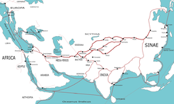
can be traced back to approximately 4000 BC from the ancient cities of Harrapa and Mohenjodaro of the Indus Valley Civilization
. Around the 1st Century AD, the ancient Silk Road
came into being, which passed through northern India
and China
.
 Ruling emperors and monarchs of ancient India constructed numerous brick roads in the cities. One of the most famous highways of medieval India is the Grand Trunk Road
. The Grand Trunk Road began in Sonargaon
near Dhaka in Bangladesh and ended at Peshawar
in modern-day Pakistan. In India, it linked several important cities from Kolkata
in the east to Amritsar
in the west, while passing through the cities of Patna
, Varanasi
, Kanpur, Agra
, Delhi
, Panipat
, Pipli
, Ambala
, Rajpura
, Ludhiana, and Jalandhar
. During the colonial period in the 19th century, the British upgraded the existing highway network and built roads in many treacherous areas such as the Western Ghats
.
The National Highways are the backbone of the road infrastructure in India. State Highways and Major District Roads constitute the secondary system of road infrastructure of India.
 Access-controlled expressways of India
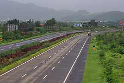
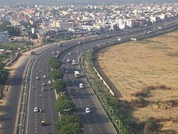
made up approximately 200 km (124.3 mi) of the Indian National Highway System in 2009, increasing to over 600 kilometers by 2011.,, These high-speed roads are four-lane or six-lane. India expects about 3,530 kilometers of expressways to come up by 2014 from the projects under construction. The government has drawn up an ambitious target to lay 18,637 kilometer network of brand new expressways by 2022.
Indian Expressways are access controlled
, feature a divider in the center and have four or six-lanes along with a shoulder on either side. Usually no two-wheelers, three-wheelers or tractor vehicles are allowed on these roads. Speeds of 120 km/h (74.6 mph) can be maintained on these roads due to separate merging lanes and the lack of speed breakers so as to ensure smooth travel. Most of the existing expressways in India are toll roads.

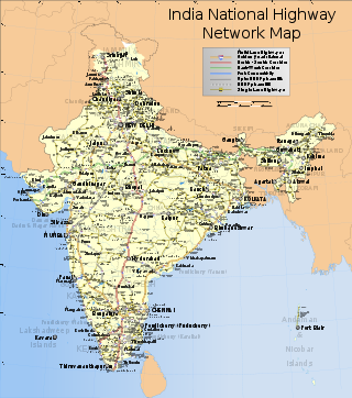 These are main highways running through the length and breadth of the country connecting major ports, state capitals, large industrial and tourist centres, etc. National Highways in India are designated as NH followed by the highway number. Indian national highways are further classified based on the width of carriageway of the highway. Generally, in case of a single lane, the lane width is of 3.75 meters, while in case of multi-lane National Highways, each of the lanes have a width of 3.5 meters.
As of February 2008, out of the total length of 7 thousand kilometers of completed highways, 14% had four or more lane
s and about 59% had 2-lanes or are double-laned, while the rest (27%) of the National Highway network had single or intermediate lane. In addition, by 2008, India had awarded numerous contracts on a public–private partnership and build-operate-transfer
model to expand its nationwide road network.
As of September 2011, India had completed and placed in use the following newly built highways:
The above 14,277 kilometers of highways connect most of the major manufacturing centers, commercial and cultural cities of India.
The National Highways Authority of India
(NHAI) is the authority responsible for the development, maintenance and management of National Highways entrusted to it. As of 2008, the NHAI is undertaking the developmental activities under National Highways Development Project (NHDP)
in phases. In addition to implementation of NHDP, the NHAI is also responsible for implementing other projects on National Highways, primarily road connectivity
to major ports in India.
The Ministry of State for Surface Transport in India administers the national highway system, and state highways and other state roads are maintained by state public works departments. The central and state governments share responsibilities for road building and maintaining Indian roads.
(PMGSY) (or "Prime Minister Rural Roads Scheme"), was launched in December 2000 by the Indian government to provide connectivity to unconnected rural habitations.these roads are constructed and maintained by the village panchayats.Their total length in 2005 was 26,50,000 km,which was about 80 percent
of all types of roads in india .
Due to decades of bureaucratic and procedural difficulties, the road network has suffered long delays. Recently however, political leaders in India are making efforts to prioritize the modernization and expansion of the road network. However, there are still other environmental, logistical, and local issues contributing to delay in development of the road infrastructure. For instance, although the government itself owns a wide corridor around the center of roads called the Right of Way (ROW), over many years, poor and landless people have built houses and other property along the roadside. Farmers whose fields adjoined the road had their crops encroach up to the side of the road. Further, other resources are located along roadsides, whether they be trees, pathways to water resources, streams that were used for their water, etc.
According to a 2007 report, trucking goods from Gurgaon
to the port in Mumbai
can take up to 10 days. Taxes and bribes are common between state borders; Transparency International estimates that truckers pay annually 5 billion in bribes. India also has the largest number of road fatalities in the world with 118,000 deaths in 2008.
The World Health Organization compilation of road network safety data for major economies found India to have the highest number of road fatalities in the World, with 105,000 road-accident caused deaths in 2006. However, adjusted for India's larger population, the accident and fatalities rates are similar to major economies. Over 2004-2007, India had a road fatality rate of 132 deaths per million citizens, compared to 131 deaths per million citizens in the United States. Non-fatal accident rates reported on Indian roads was 429 accidents per million citizens, compared to 412 accidents per million citizens in China, and 1101 accidents per million citizens in the United States. The report notes that not all accidents in India and China are reported and recorded.
A 2005 research article found Indian cities as extremely congested — the average bus speed is 6–10 km/h in many large cities. Because of the congestion in Indian roads the fuel efficiency of the vehicles is also very low. This increases the overall fuel consumption per equivalent kilometer travelled, besides resulting in heavy pollution since the engines run very inefficiently at such low speeds. Pollutants from poor road network and resultant poor fuel efficiencies include hydrocarbons, NOx, SOx, methane, carbon monoxide and carbon dioxide - all of which cause health problems, adverse climate effects and related environmental damage.
Due to rising prices of petroleum
, being a non-renewable resource
, some have urged the Indian government to focus instead on improving public transport like the Indian Railways
and rapid transit
systems.
India's recent efforts to build modern highways and improve its road network has made a significant difference in trucking logistics. According to DHL, a global logistics company, the average time to truck shipments from New Delhi to Bengaluru (Bangalore), a 2000+ kilometer journey, had dropped in 2008, to about five days. By 2010, the average time to complete a road trip from New Delhi to Mumbai, a 1400+ kilometer journey, had dropped to about 35 hours. In contrast, a similar journey takes about half the time in China, and one third in European Union countries.
In a 2010 report, KPMG
- one of the world's largest audit and advisory services company - noted marked improvements in Indian road network and logistics efficiencies in recent years. The report also identified the competitive challenges faced by India. Some findings of this report include:
The KPMG report also notes that India's road network logistics and transportation bottlenecks hinder its GDP growth by one to two percent (US$16 billion - US$32 billion). In India's 2010 per capita income basis, this is equivalent to a loss of about 10 million new jobs every year.
Poor rural roads and traffic congestion inside the cities remains a challenge in India. The planned addition of over 12,000 kilometers of expressways in the next 10 years may help address some of such issues.
The constraints and issues with Indian road network differ from one state to another. Some states, such as Gujarat, have remarkably better road network than others. In a 2011 report, The Economist notes that Gujarat's infrastructure competes with Guangdong in China, and with double digit growth rates, Gujarat continues to outpace growth in other Indian states. Beyond better road networks, The Economist article claims the state government of Gujarat has kept red tape to a minimum, does not ask for bribes, and does not interfere with entrepreneurial corporations. The state, the article claims has less onerous labour laws, reliable electricity and effective bureaucracy.
India, in its past, had not allocated resources to build or maintain its road network. This has changed in the last 15 years, with major efforts currently underway to modernize the country's road infrastructure. India plans to spend approximately 70 Billion by 2013 to modernize its highway network.
As of October 2011, India had completed and placed in use over 14,000 kilometers of recently built 4-lane highways connecting many of its major manufacturing centers, commercial and cultural centers.
Some of the major projects that are being implemented include the National Highways Development Project
National Highways Development Project
The National Highways Development Project is a project to upgrade, rehabilitate and widen major highways in India to a higher standard. The project was implemented in 1998. "National Highways" account for only about 2% of the total length of roads, but carry about 40% of the total traffic across...
, Yamuna Expressway
Yamuna Expressway
Yamuna Expressway , formerly known as Taj Expressway project was conceived with the idea of reducing the travel time between Noida and Agra...
and the Mumbai-Pune Expressway.
According to recent estimates by Goldman Sachs, India
India
India , officially the Republic of India , is a country in South Asia. It is the seventh-largest country by geographical area, the second-most populous country with over 1.2 billion people, and the most populous democracy in the world...
will need to invest 1.7 trillion on infrastructure projects over the next decade to boost economic growth. In an effort to accomplish this, the government of India
Government of India
The Government of India, officially known as the Union Government, and also known as the Central Government, was established by the Constitution of India, and is the governing authority of the union of 28 states and seven union territories, collectively called the Republic of India...
is attempting to promote foreign investment in road projects by offering financial incentives such as toll rights to developers.
History
Indian subcontinent
The Indian subcontinent, also Indian Subcontinent, Indo-Pak Subcontinent or South Asian Subcontinent is a region of the Asian continent on the Indian tectonic plate from the Hindu Kush or Hindu Koh, Himalayas and including the Kuen Lun and Karakoram ranges, forming a land mass which extends...
can be traced back to approximately 4000 BC from the ancient cities of Harrapa and Mohenjodaro of the Indus Valley Civilization
Indus Valley Civilization
The Indus Valley Civilization was a Bronze Age civilization that was located in the northwestern region of the Indian subcontinent, consisting of what is now mainly modern-day Pakistan and northwest India...
. Around the 1st Century AD, the ancient Silk Road
Silk Road
The Silk Road or Silk Route refers to a historical network of interlinking trade routes across the Afro-Eurasian landmass that connected East, South, and Western Asia with the Mediterranean and European world, as well as parts of North and East Africa...
came into being, which passed through northern India
India
India , officially the Republic of India , is a country in South Asia. It is the seventh-largest country by geographical area, the second-most populous country with over 1.2 billion people, and the most populous democracy in the world...
and China
China
Chinese civilization may refer to:* China for more general discussion of the country.* Chinese culture* Greater China, the transnational community of ethnic Chinese.* History of China* Sinosphere, the area historically affected by Chinese culture...
.
Grand Trunk Road
The Grand Trunk Road also formerly known as Uttarapatha, Shah Rah-e-Azam or Sadak-e-Azam or Badshahi Sadak is one of South Asia's oldest and longest major roads...
. The Grand Trunk Road began in Sonargaon
Sonargaon
Sonargaon is the ancient capital of Isa Khan's kingdom in Bengal. It is located near the current-day city of Narayanganj, Bangladesh....
near Dhaka in Bangladesh and ended at Peshawar
Peshawar
Peshawar is the capital of Khyber-Pakhtunkhwa and the administrative center and central economic hub for the Federally Administered Tribal Areas of Pakistan....
in modern-day Pakistan. In India, it linked several important cities from Kolkata
Kolkata
Kolkata , formerly known as Calcutta, is the capital of the Indian state of West Bengal. Located on the east bank of the Hooghly River, it was the commercial capital of East India...
in the east to Amritsar
Amritsar
Amritsar is a city in the northern part of India and is the administrative headquarters of Amritsar district in the state of Punjab, India. The 2001 Indian census reported the population of the city to be over 1,500,000, with that of the entire district numbering 3,695,077...
in the west, while passing through the cities of Patna
Patna
Paṭnā , is the capital of the Indian state of Bihar and the second largest city in Eastern India . Patna is one of the oldest continuously inhabited places in the world...
, Varanasi
Varanasi
-Etymology:The name Varanasi has its origin possibly from the names of the two rivers Varuna and Assi, for the old city lies in the north shores of the Ganga bounded by its two tributaries, the Varuna and the Asi, with the Ganges being to its south...
, Kanpur, Agra
Agra
Agra a.k.a. Akbarabad is a city on the banks of the river Yamuna in the northern state of Uttar Pradesh, India, west of state capital, Lucknow and south from national capital New Delhi. With a population of 1,686,976 , it is one of the most populous cities in Uttar Pradesh and the 19th most...
, Delhi
Delhi
Delhi , officially National Capital Territory of Delhi , is the largest metropolis by area and the second-largest by population in India, next to Mumbai. It is the eighth largest metropolis in the world by population with 16,753,265 inhabitants in the Territory at the 2011 Census...
, Panipat
Panipat
Panipat بَنِبَت is an ancient and historic city in Panipat district, Haryana state, India. It is 90 km north from Delhi and 169 km south of Chandigarh on NH-1. The three battles fought at the city were turning points in Indian history. The city is famous in India by the name of "City of...
, Pipli
Pipli
Pipli is a small village in Gaighata, North 24 Parganas, West Bengal, India.The village is near the Ichamati River which acts as a border between India and Bangladesh. Pipli has two primary schools.-Google Map:-Source:...
, Ambala
Ambala
Ambala is a city and a municipal corporation in Ambala district in the state of Haryana, India, located on the border of the states of Haryana and Punjab in India. Politically; Ambala has two sub-areas: Ambala Cantt and Ambala City, approximately 3 kilometers apart from each other...
, Rajpura
Rajpura
Rajpura is a city and a municipal council in Patiala district in the Indian state of Punjab.-Geography:Rajpura is located at . It has an average elevation of 259 metres ....
, Ludhiana, and Jalandhar
Jalandhar
Jalandhar is a city in Jalandhar District in the state of Punjab, India. It is located 144 km northwest of the state capital, Chandigarh...
. During the colonial period in the 19th century, the British upgraded the existing highway network and built roads in many treacherous areas such as the Western Ghats
Western Ghats
The Western Ghats, Western Ghauts or the Sahyādri is a mountain range along the western side of India. It runs north to south along the western edge of the Deccan Plateau, and separates the plateau from a narrow coastal plain along the Arabian Sea. The Western Ghats block rainfall to the Deccan...
.
Statistics
In general, roads in India are primarily bitumen-based macadamized roads. However, a few of the National Highways have concrete roads too. In some locations, such as in Kanpur, British-built concrete roads are still in use. Concrete roads were less popular prior to 1990s because of low availability of cement then. However, with large supplies of cement in the country and the virtues of concrete roads, they are once again gaining popularity. Concrete roads are weather-proof and require lower maintenance compared to bituminous roads.| Class | Length (km) |
|---|---|
| National Highways/Expressways | 66,754 |
| State Highways | 128,000 |
| Major district roads | 470,000 |
| Rural & other roads | 2,650,000 |
| Total (approx) | 3,314,754 |
| Class | Percent (%) |
|---|---|
| Paved Roads (% of 2 lane roads) | 34 |
| Paved Roads (% of 4 lane roads) | 1 |
| Paved Roads (% of total road network) | 47.3 |
The National Highways are the backbone of the road infrastructure in India. State Highways and Major District Roads constitute the secondary system of road infrastructure of India.
Expressways
India
India , officially the Republic of India , is a country in South Asia. It is the seventh-largest country by geographical area, the second-most populous country with over 1.2 billion people, and the most populous democracy in the world...
made up approximately 200 km (124.3 mi) of the Indian National Highway System in 2009, increasing to over 600 kilometers by 2011.,, These high-speed roads are four-lane or six-lane. India expects about 3,530 kilometers of expressways to come up by 2014 from the projects under construction. The government has drawn up an ambitious target to lay 18,637 kilometer network of brand new expressways by 2022.
Indian Expressways are access controlled
Limited-access road
A limited-access road known by various terms worldwide, including limited-access highway, dual-carriageway and expressway, is a highway or arterial road for high-speed traffic which has many or most characteristics of a controlled-access highway , including limited or no access to adjacent...
, feature a divider in the center and have four or six-lanes along with a shoulder on either side. Usually no two-wheelers, three-wheelers or tractor vehicles are allowed on these roads. Speeds of 120 km/h (74.6 mph) can be maintained on these roads due to separate merging lanes and the lack of speed breakers so as to ensure smooth travel. Most of the existing expressways in India are toll roads.
National Highways
As of February 2008, out of the total length of 7 thousand kilometers of completed highways, 14% had four or more lane
Lane
A lane is a part of the roadway within a road marked out for use by a single line of vehicles in such a way as to control and guide drivers for the purpose of reducing traffic conflicts. Most public roads have at least two lanes, one for traffic in each direction, separated by Lane markings...
s and about 59% had 2-lanes or are double-laned, while the rest (27%) of the National Highway network had single or intermediate lane. In addition, by 2008, India had awarded numerous contracts on a public–private partnership and build-operate-transfer
Build-Operate-Transfer
Build-own-operate-transfer or build-operate-transfer is a form of project financing, wherein a private entity receives a concession from the private or public sector to finance, design, construct, and operate a facility stated in the concession contract...
model to expand its nationwide road network.
As of September 2011, India had completed and placed in use the following newly built highways:
- 5,829 kilometers of its 4-lane Golden QuadrilateralGolden QuadrilateralThe Golden Quadrilateral is a highway network connecting India's four largest metropolises: Delhi, Mumbai, Chennai and Kolkata, thus forming a quadrilateral of sorts. Four other top ten metropolises: Bangalore, Pune, Ahmedabad, and Surat, are also served by the network...
highway, - 5,831 kilometers of its 4-lane North–South and East–West Corridor highway,
- 330 kilometers of 4-lane port connectivity highways,
- 1,342 kilometers of 4-lane inter-capital highways,
- 945 kilometers of 4-lane bypass and other national highways.
The above 14,277 kilometers of highways connect most of the major manufacturing centers, commercial and cultural cities of India.
The National Highways Authority of India
National Highways Authority of India
The National Highways Authority of India is an autonomous agency of the Government of India, responsible for management of a network of over 60,000 km of National Highways in India...
(NHAI) is the authority responsible for the development, maintenance and management of National Highways entrusted to it. As of 2008, the NHAI is undertaking the developmental activities under National Highways Development Project (NHDP)
National Highways Development Project
The National Highways Development Project is a project to upgrade, rehabilitate and widen major highways in India to a higher standard. The project was implemented in 1998. "National Highways" account for only about 2% of the total length of roads, but carry about 40% of the total traffic across...
in phases. In addition to implementation of NHDP, the NHAI is also responsible for implementing other projects on National Highways, primarily road connectivity
Landscape connectivity
Landscape connectivity is "the degree to which the landscape facilitates or impedes movement among resource patches" It has two components:*Structural connectivity: the spatial structure of a landscape and can be described from map elements...
to major ports in India.
| Lanes | Length (km) | Percentage |
|---|---|---|
| Single Lane / Intermediate lane | 18,350 | 27% |
| Double lane | 39,079 | 59% |
| Four Lane/Six lane/Eight Lane | 9,325 | 14% |
| Total | 66,754 | 100% |
State Highways
The State Highways provide linkages with the National Highways, district headquarters, important towns, tourist centres and minor ports and carry the traffic along major centers within the state. These arterial routes provides connectivity to important towns and cities within the state with National Highways or State Highways of the neighboring states. Their total length is about 137,712 km.The Ministry of State for Surface Transport in India administers the national highway system, and state highways and other state roads are maintained by state public works departments. The central and state governments share responsibilities for road building and maintaining Indian roads.
District road
These are important roads within a district connecting areas of production with markets and connecting these with each other or with the State Highways & National Highways. It also connects Taluka headquarters and rural areas to District headquarters within the state.| State/UT | Single lane (km) | Intermediate lane (km) | Double lane (km) | Multilane (km) | Total (km) |
|---|---|---|---|---|---|
| Kerala | 18900 | ||||
| Tamil Nadu | 4,797 | 757 | 1,761 | 47 | 7,362 |
Rural and other roads
The rural roads in India forms a substantial portion of the Indian road network. For the development of these rural roads, Pradhan Mantri Gram Sadak YojanaPradhan Mantri Gram Sadak Yojana
The Pradhan Mantri Gram Sadak Yojana or PMGSY is a nationwide plan in India to provide good all-weather road connectivity to unconnected villages...
(PMGSY) (or "Prime Minister Rural Roads Scheme"), was launched in December 2000 by the Indian government to provide connectivity to unconnected rural habitations.these roads are constructed and maintained by the village panchayats.Their total length in 2005 was 26,50,000 km,which was about 80 percent
of all types of roads in india .
Issues
The main roads in India are under huge pressure and in great need of modernization in order to handle the increased requirements of the Indian economy. In addition to maintenance, the expansion of the network and widening of existing roads is becoming increasingly important. This would then enable the roads to handle increased traffic, and also allow for a corresponding increase in the average movement speed on India's roads. Presently, lane capacity is low and only about 16% of India's roads are four lanes or above. In addition, approximately a quarter of all India's highways are congested, in some cases reducing truck and bus speeds to 30-40 km/h (19-25 mph). Road maintenance remains under-funded, and some 40 percent of villages in India lack access to all-weather roads.Due to decades of bureaucratic and procedural difficulties, the road network has suffered long delays. Recently however, political leaders in India are making efforts to prioritize the modernization and expansion of the road network. However, there are still other environmental, logistical, and local issues contributing to delay in development of the road infrastructure. For instance, although the government itself owns a wide corridor around the center of roads called the Right of Way (ROW), over many years, poor and landless people have built houses and other property along the roadside. Farmers whose fields adjoined the road had their crops encroach up to the side of the road. Further, other resources are located along roadsides, whether they be trees, pathways to water resources, streams that were used for their water, etc.
According to a 2007 report, trucking goods from Gurgaon
Gurgaon
Gurgaon is the second largest city in the Indian state of Haryana. Gurgaon is the industrial and financial center of Haryana. It is located 30 km south of national capital New Delhi, about 10 kilometers from Dwarka Sub City and 268 km south of Chandigarh, the state capital...
to the port in Mumbai
Mumbai
Mumbai , formerly known as Bombay in English, is the capital of the Indian state of Maharashtra. It is the most populous city in India, and the fourth most populous city in the world, with a total metropolitan area population of approximately 20.5 million...
can take up to 10 days. Taxes and bribes are common between state borders; Transparency International estimates that truckers pay annually 5 billion in bribes. India also has the largest number of road fatalities in the world with 118,000 deaths in 2008.
The World Health Organization compilation of road network safety data for major economies found India to have the highest number of road fatalities in the World, with 105,000 road-accident caused deaths in 2006. However, adjusted for India's larger population, the accident and fatalities rates are similar to major economies. Over 2004-2007, India had a road fatality rate of 132 deaths per million citizens, compared to 131 deaths per million citizens in the United States. Non-fatal accident rates reported on Indian roads was 429 accidents per million citizens, compared to 412 accidents per million citizens in China, and 1101 accidents per million citizens in the United States. The report notes that not all accidents in India and China are reported and recorded.
A 2005 research article found Indian cities as extremely congested — the average bus speed is 6–10 km/h in many large cities. Because of the congestion in Indian roads the fuel efficiency of the vehicles is also very low. This increases the overall fuel consumption per equivalent kilometer travelled, besides resulting in heavy pollution since the engines run very inefficiently at such low speeds. Pollutants from poor road network and resultant poor fuel efficiencies include hydrocarbons, NOx, SOx, methane, carbon monoxide and carbon dioxide - all of which cause health problems, adverse climate effects and related environmental damage.
Due to rising prices of petroleum
Petroleum
Petroleum or crude oil is a naturally occurring, flammable liquid consisting of a complex mixture of hydrocarbons of various molecular weights and other liquid organic compounds, that are found in geologic formations beneath the Earth's surface. Petroleum is recovered mostly through oil drilling...
, being a non-renewable resource
Non-renewable resource
A non-renewable resource is a natural resource which cannot be produced, grown, generated, or used on a scale which can sustain its consumption rate, once depleted there is no more available for future needs. Also considered non-renewable are resources that are consumed much faster than nature...
, some have urged the Indian government to focus instead on improving public transport like the Indian Railways
Indian Railways
Indian Railways , abbreviated as IR , is a departmental undertaking of Government of India, which owns and operates most of India's rail transport. It is overseen by the Ministry of Railways of the Government of India....
and rapid transit
Rapid transit
A rapid transit, underground, subway, elevated railway, metro or metropolitan railway system is an electric passenger railway in an urban area with a high capacity and frequency, and grade separation from other traffic. Rapid transit systems are typically located either in underground tunnels or on...
systems.
Efforts in India to address issues related to road network
India's recent efforts to build modern highways and improve its road network has made a significant difference in trucking logistics. According to DHL, a global logistics company, the average time to truck shipments from New Delhi to Bengaluru (Bangalore), a 2000+ kilometer journey, had dropped in 2008, to about five days. By 2010, the average time to complete a road trip from New Delhi to Mumbai, a 1400+ kilometer journey, had dropped to about 35 hours. In contrast, a similar journey takes about half the time in China, and one third in European Union countries.
In a 2010 report, KPMG
KPMG
KPMG is one of the largest professional services networks in the world and one of the Big Four auditors, along with Deloitte, Ernst & Young and PwC. Its global headquarters is located in Amstelveen, Netherlands....
- one of the world's largest audit and advisory services company - noted marked improvements in Indian road network and logistics efficiencies in recent years. The report also identified the competitive challenges faced by India. Some findings of this report include:
- The average road speed in India has increased to 30-40 kilometers per hour. The worldwide average road speed, which includes China, ranges between 60-80 kilometers per hour.
- Four lane road network in India has increased to 7,000 kilometers. China, in comparison, has 34,000 kilometers of equivalent quality four lane roads.
- Average surface freight costs have dropped to US$0.07 per kilometer. Japan, in comparison, has average surface freight costs of US$0.037 per kilometer.
The KPMG report also notes that India's road network logistics and transportation bottlenecks hinder its GDP growth by one to two percent (US$16 billion - US$32 billion). In India's 2010 per capita income basis, this is equivalent to a loss of about 10 million new jobs every year.
Poor rural roads and traffic congestion inside the cities remains a challenge in India. The planned addition of over 12,000 kilometers of expressways in the next 10 years may help address some of such issues.
The constraints and issues with Indian road network differ from one state to another. Some states, such as Gujarat, have remarkably better road network than others. In a 2011 report, The Economist notes that Gujarat's infrastructure competes with Guangdong in China, and with double digit growth rates, Gujarat continues to outpace growth in other Indian states. Beyond better road networks, The Economist article claims the state government of Gujarat has kept red tape to a minimum, does not ask for bribes, and does not interfere with entrepreneurial corporations. The state, the article claims has less onerous labour laws, reliable electricity and effective bureaucracy.
See also
- World Bank's Research Report on "Rural Roads - A Lifeline for Villages in India"
- India Transport - Roadways and Other Infrastructure
- India Infrastructure - Projects Status Database published by the Government of India
- National Highways Development ProjectNational Highways Development ProjectThe National Highways Development Project is a project to upgrade, rehabilitate and widen major highways in India to a higher standard. The project was implemented in 1998. "National Highways" account for only about 2% of the total length of roads, but carry about 40% of the total traffic across...
- List of National Highways in India
- List of National Highways in India (by Highway Number)
- List of State Highways in India under implementation - a 2010 status report by the Government of India
- Border Roads OrganisationBorder Roads OrganisationThe Border Roads Organisation maintains roads that serve the borders areas of India. It is staffed with a combination of Border Roads Engineering Service officers from the General Reserve Engineer Force and officers from the Corps of Engineers of the Indian Army. The organisation develops and...
- National Highways Authority of IndiaNational Highways Authority of IndiaThe National Highways Authority of India is an autonomous agency of the Government of India, responsible for management of a network of over 60,000 km of National Highways in India...
- Transport in IndiaTransport in IndiaTransport in the Republic of India is an important part of the nation's economy. Since the economic liberalisation of the 1990s, development of infrastructure within the country has progressed at a rapid pace, and today there is a wide variety of modes of transport by land, water and air...