

Inca Trail to Machu Picchu
Encyclopedia

Andes
The Andes is the world's longest continental mountain range. It is a continual range of highlands along the western coast of South America. This range is about long, about to wide , and of an average height of about .Along its length, the Andes is split into several ranges, which are separated...
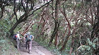
mountain range, the trail passes through several types of Andean environments including cloud forest
Cloud forest
A cloud forest, also called a fog forest, is a generally tropical or subtropical evergreen montane moist forest characterized by a persistent, frequent or seasonal low-level cloud cover, usually at the canopy level. Cloud forests often exhibit an abundance of mosses covering the ground and...
and alpine tundra
Alpine tundra
Alpine tundra is a natural region that does not contain trees because it is at high altitude. Alpine tundra is distinguished from arctic tundra, because alpine soils are generally better drained than arctic soils...
. Settlements, tunnels, and many Incan ruins are located along the trail before ending the terminus at the Sun Gate on Machu Picchu
Machu Picchu
Machu Picchu is a pre-Columbian 15th-century Inca site located above sea level. It is situated on a mountain ridge above the Urubamba Valley in Peru, which is northwest of Cusco and through which the Urubamba River flows. Most archaeologists believe that Machu Picchu was built as an estate for...
mountain. The two longer routes require an ascent to beyond 3660 metres (12,007.9 ft) above sea level, which can result in altitude sickness
Altitude sickness
Altitude sickness—also known as acute mountain sickness , altitude illness, hypobaropathy, or soroche—is a pathological effect of high altitude on humans, caused by acute exposure to low partial pressure of oxygen at high altitude...
.
Concern about overuse leading to erosion has led the Peruvian government to place a limit on the number of people who may hike this trail per season, and to sharply limit the companies that can provide guides. As a result, advance booking is mandatory. A maximum of 500 people, including guides and porters, are permitted to begin the trail every day. As a result, the high season books out very quickly.
The trail is closed every February for cleaning.
Classic trail
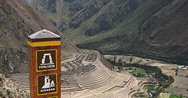
It starts from one of two points: 88 km (55 miles) or 82 km (51 miles) from Cuzco on the Urubamba River at approximately 2800 metres (9,186.4 ft) altitude.
Both of these trail segments meet above the Inca ruins of Patallacta (aka Llaqtapata), a site used for religious and ceremonial functions, crop production, and housing for soldiers from the nearby hilltop site of Willkaraqay, an ancient pre-Inca site first inhabited around 500 BC.
The trail undulates, but overall ascends along Rio Cusichca (aka River Kusichca aka "happy river").
At the small village of Wayllabamba the trail intersects with the "Mollepata Trail" at 3000 metres (9,842.5 ft)
Small, permanent settlements are located adjacent to the trail, and Wayllabamba has approximately 400 inhabitants (130 families) spread along this portion of the trail. Pack animals—horses, mules, donkeys, and llamas—are allowed.
At Wayllabamba the trail to Machu Picchu turns west and begins ascending along a tributary of the Cusichca. Because of previous damage caused by hooves, pack animals are not allowed on the remainder of the trail. For the same reason, metal-tipped trekking poles are not allowed on the trail.
Habitat
* Habitat , a place where a species lives and grows*Human habitat, a place where humans live, work or play** Space habitat, a space station intended as a permanent settlement...
s, one of which is a cloud forest containing Polylepis
Polylepis
Polylepis is a genus containing about twenty species of shrubs or trees native to the mid- and high-elevation regions of the tropical Andes. This group is unique in the rose family in that it is predominantly wind-pollinated. They are usually gnarled in shape, but in certain areas some trees are...
trees. The campsite at Llulluchapampa is located on this stretch of trail at 3800 metres (12,467.2 ft). The pass itself is located at 4215 m (13,828.7 ft). above sea level, and is the highest point on this, the "Classic" trail.
After crossing the pass the trail drops steeply into the Pacaymayu River drainage. At a distance of 2.1 km and 600 m below the pass is the campground Pacaymayu.
Tambo (Incan structure)
A Tambo was an Incan structure built for administrative and military purposes. Found along Incan roads, tambos typically carried supplies, served as lodging for itinerant state personnel, and were depositories of quipu-based accounting records.Different types of tambos existed; those that served...
of Runkuraqay, which overlooks the valley. The site was heavily restored in the late 1990s.
The trail continues to ascend, passing a small lake named Laguna Cochapata in an area that is recognized as deer habitat. This site had been used as a camp site. As with other sites that were being degraded due to overuse, camping is no longer allowed. The trail reaches the pass at an altitude of 3,950 m.
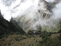
The Trail continues through high cloud forest, undulating, sometimes steeply while affording increasingly dramatic viewpoints of mountains and dropoffs. A long Inca tunnel and a viewpoint overlooking two valleys: the Urubamba and Aobamba, are passed.

Hiram Bingham discovered the site, but left most of it covered with vegetation. The Fejos team named the site, and uncovered the remainder. Design of the site closely follows the natural contours, and includes five fountains and an altar, which was probably used for llama sacrifice.
The trail then descends approximately 1000 metres including an irregular staircase of from 1300 to 1500 steps, some of which were carved into solid granite. Vegetation becomes more dense, lush, and "jungle" like with an accompanying increase in butterflies and birds. A second Incan tunnel is along this section of trail.
Even before passing through the tunnel there are views down to the Urubamba River
Urubamba River
The Urubamba River is a river in Peru. A partially navigable headwater of the Amazon River, it rises in the Andes to the south-east of Cuzco near the Puno Region border, where it is called the Vilcanota River . In the Sacred Valley, between Písac and Ollantaytambo, it is also called the Wilcamayu...
, the first since leaving the river at Patallacta. The number of these views increases. After the tunnel the town of Aguas Calientes
Aguas Calientes, Peru
Aguas Calientes is the colloquial name for "Hot Springs", a town in Peru on the Urubamba River. It is best known as the closest access point to the sacred historical site of Machu Picchu , which is away, about 1.5 hours walk. There are many hotels and restaurants for tourists, as well as natural...
can be seen, and trains running along the river can be heard. As the trail nears Intipata, it affords views of the "Two Day" Inca Trail (aka "Camino Real de los Inkas" or "One Day Inca Trail"). A small spur of the trail leads directly to Wiñay Wayna
Wiñay Wayna
Wiñay Wayna is an Inca ruin along the Inca Trail to Machu Picchu. It is built into a steep hillside overlooking the Urubamba River. The site consists of upper and lower house complexes connected by a staircase and fountain structures...
, while the main route continues to Intipata.
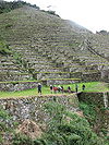
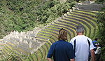
Intipata (sunny place aka Yunkapata) is a recently uncovered extensive set of agricultural terraces which follow the convex shape of the terrain. Potatoes, maize
Maize
Maize known in many English-speaking countries as corn or mielie/mealie, is a grain domesticated by indigenous peoples in Mesoamerica in prehistoric times. The leafy stalk produces ears which contain seeds called kernels. Though technically a grain, maize kernels are used in cooking as a vegetable...
, fruit, and sweet potato
Sweet potato
The sweet potato is a dicotyledonous plant that belongs to the family Convolvulaceae. Its large, starchy, sweet-tasting, tuberous roots are an important root vegetable. The young leaves and shoots are sometimes eaten as greens. Of the approximately 50 genera and more than 1,000 species of...
were grown here.
From Wiñay Wayna the trail undulates along below the crest of the east slope of the mountain named Machu Picchu. The steep stairs leading to Intipunku (sun gate) are reached after approximately 3 km. Reaching the crest of this ridge reveals the grandeur of the ruins of Machu Picchu, which lie below. A short downhill walk is the final section of the trail.
See also
- Iperu, tourist information and assistanceIperu, tourist information and assistanceIperú, Tourist Information and Assistance, or simply iperú is the free tourism office provided by the Peruvian government through the Commission for the Promotion of Export and Tourism Peru and the National Institute for Defense Competition and Protection of...
- Lares trekLares trekThe Lares trek is a two or three day high altitude hike in Cusco Peru starting near the village of Lares, approximately 40 miles north of Cusco and 35 miles east of Machu Picchu. The Lares Valley lies to the east of the Urubamba range, traversing part of the Sacred Valley. Reaching the start of...
, one of the alternative routes to Machu Picchu - Tourism in PeruTourism in PeruTourism in Peru make up the nation's third largest industry, behind fishing and mining. Tourism is directed towards archeological monuments, ecotourism in the Peruvian Amazon, cultural tourism in colonial cities, gastronomic tourism, adventure tourism, and beach tourism. According to a Peruvian...
Further reading
- Moseley, Michael 1992. The Incas and their Ancestors: The archaeology of Peru. Thames and Hudson, New York.
- Hyslop, John, 1984. Inka Road System. Academic Press, New York.
- Inca: Lords of Gold and Glory. Virginia: Time-Life Books, 1992.
- Andean World: Indigenous History: Culture and Consciousness by Kenneth Adrien.
- Footprints Cusco and The Inca Trail Handbook by Peter FrostPeter Frost (archaeologist)Peter Frost is a British writer, photographer, and archaeologist who spent much of his time exploring Peru and wrote several books about the country. While leading a National Geographic expedition, Frost discovered the pre-Inca site of Qoriwayrachina....
and Ben Box - Jenkins, David "A Network Analysis of Inka Roads, Administrative Centers and Storage Facilities." Ethnohistory, 48:655-685 (Fall, 2001).
External links
- Inca Trail Tips and useful Information Details about the Inca Trail to Machu Picchu
- Site Qhapaq Ñan, the Great Inca Road - 6000 km on foot across the Andes
- View a portion of the Inca Trail, leading to Machu Picchu, in Google Earth
- Detailed description of the historic sites along the classic Inca Trail