

Iapetus Suture
Encyclopedia
The Iapetus Suture is one of several major geological faults caused by the collision of several ancient land masses forming a suture
. It represents in part the remains of what was once the Iapetus Ocean
. Iapetus was the father of Atlas in Greek mythology, making his an appropriate name for what used to be called the 'Proto-Atlantic Ocean'. When the Atlantic ocean opened, in the Cretaceous period, it took a slightly different line from that of the Iapetus suture, with some originally Laurentian rocks being left behind in north-west Europe and other, Avalonian, rocks remaining as part of Newfoundland.
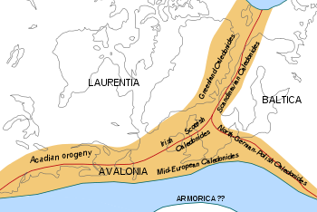
approximately 600 million years ago and was bordered by several paleocontinents: Laurentia
, Ganderia, Carolinia, Avalonia
, and Baltica
. During a series of geological events, the Salinic orogeny and Caledonian orogeny
all three land masses began to converge upon each other slowly diminishing the ocean by subducting the oceanic crust. By the end of the Silurian period
, approximately 420 million years ago, the ocean had disappeared. The geological fault zone resulting from the continental collision is known as the Iapetus Suture, named after the ocean it replaced.
The closure of Iapetus involved a complex and protracted collisional history of numerous micro-continents, volcanic arcs and back-arc basins that were accreted to Laurentia
and Avalonia between the Early Ordovician
and Late Silurian
. The notion of a single suture zone in a complex orogen such as the Appalachian/Caledonian is unrealistic as several temporal and spatial distinct suture zones are present.
. It is readily visible in present-day Niarbyl
on the southwest coast of Isle of Man
. The fault is manifested by two major rock groups
which abut each other, both deposited by their respective, aforementioned continents - the Manx Group to the south/east and the Dalby Group to the north/west. The Niarbyl fault is evidence of two paleocontinents colliding: Avalonia
on which present-day England
is located and Laurentia which contains both present-day North America
and Scotland
.
The fault is visible close to the shoreline downhill from the Niarbyl Cafe and Visitor Centre in Niarbyl.
. The Iapetus Suture runs from the Solway Firth
to Lindisfarne
.
Suture (geology)
In structural geology, a suture is a major fault zone through an orogen or mountain range. Sutures separate terranes, tectonic units that have different plate tectonic, metamorphic and paleogeographic histories...
. It represents in part the remains of what was once the Iapetus Ocean
Iapetus Ocean
The Iapetus Ocean was an ocean that existed in the Neoproterozoic and Paleozoic eras of the geologic timescale . The Iapetus Ocean was situated in the southern hemisphere, between the paleocontinents of Laurentia, Baltica and Avalonia...
. Iapetus was the father of Atlas in Greek mythology, making his an appropriate name for what used to be called the 'Proto-Atlantic Ocean'. When the Atlantic ocean opened, in the Cretaceous period, it took a slightly different line from that of the Iapetus suture, with some originally Laurentian rocks being left behind in north-west Europe and other, Avalonian, rocks remaining as part of Newfoundland.
Background
The Iapetus Ocean was an ancient ocean which existed in the Southern HemisphereSouthern Hemisphere
The Southern Hemisphere is the part of Earth that lies south of the equator. The word hemisphere literally means 'half ball' or "half sphere"...
approximately 600 million years ago and was bordered by several paleocontinents: Laurentia
Laurentia
Laurentia is a large area of continental craton, which forms the ancient geological core of the North American continent...
, Ganderia, Carolinia, Avalonia
Avalonia
Avalonia was a microcontinent in the Paleozoic era. Crustal fragments of this former microcontinent underlie south-west Great Britain, and the eastern coast of North America. It is the source of many of the older rocks of Western Europe, Atlantic Canada, and parts of the coastal United States...
, and Baltica
Baltica
Baltica is a name applied by geologists to a late-Proterozoic, early-Palaeozoic continent that now includes the East European craton of northwestern Eurasia. Baltica was created as an entity not earlier than 1.8 billion years ago. Before this time, the three segments/continents that now comprise...
. During a series of geological events, the Salinic orogeny and Caledonian orogeny
Caledonian orogeny
The Caledonian orogeny is a mountain building era recorded in the northern parts of the British Isles, the Scandinavian Mountains, Svalbard, eastern Greenland and parts of north-central Europe. The Caledonian orogeny encompasses events that occurred from the Ordovician to Early Devonian, roughly...
all three land masses began to converge upon each other slowly diminishing the ocean by subducting the oceanic crust. By the end of the Silurian period
Silurian
The Silurian is a geologic period and system that extends from the end of the Ordovician Period, about 443.7 ± 1.5 Mya , to the beginning of the Devonian Period, about 416.0 ± 2.8 Mya . As with other geologic periods, the rock beds that define the period's start and end are well identified, but the...
, approximately 420 million years ago, the ocean had disappeared. The geological fault zone resulting from the continental collision is known as the Iapetus Suture, named after the ocean it replaced.
The closure of Iapetus involved a complex and protracted collisional history of numerous micro-continents, volcanic arcs and back-arc basins that were accreted to Laurentia
Laurentia
Laurentia is a large area of continental craton, which forms the ancient geological core of the North American continent...
and Avalonia between the Early Ordovician
Ordovician
The Ordovician is a geologic period and system, the second of six of the Paleozoic Era, and covers the time between 488.3±1.7 to 443.7±1.5 million years ago . It follows the Cambrian Period and is followed by the Silurian Period...
and Late Silurian
Silurian
The Silurian is a geologic period and system that extends from the end of the Ordovician Period, about 443.7 ± 1.5 Mya , to the beginning of the Devonian Period, about 416.0 ± 2.8 Mya . As with other geologic periods, the rock beds that define the period's start and end are well identified, but the...
. The notion of a single suture zone in a complex orogen such as the Appalachian/Caledonian is unrealistic as several temporal and spatial distinct suture zones are present.
The Iapetus suture in Canada
The Early Ordovician (Taconic) Baie Verte Line in Newfoundland and Quebec marks the boundary between the continental margin of Laurentia and Iapetan oceanic rocks, while the Early Ordovician (Penobscot) GRUB Line defines the contact between the vestiges of Iapetus and Ganderia. The Middle Ordovician Red Indian Line is considered the main Iapetan suture zone in that it separates peri-Laurentian and peri-Gondwanan oceanic elements. The Dog Bay Line is a younger feature in the Appalachians and delineates the terminal Iapetan suture in Newfoundland as it marks the Early Silurian (Salinic) collisional zone between Ganderia and Laurentia.The Iapetus Suture in Ireland
The estuary of the River Shannon (Ireland's largest river) follows the line of the Iapetus suture on the west coast. The suture reaches the east coast at Clogherhead in County Louth. Ireland's crust (and sedimentary rocks) to the north-west of the suture originally derives from Laurentia (proto-North America), while the crust to the south-east is Avalonian ('European').Niarbyl Fault (The Iapetus Suture in the Isle of Man)
The Niarbyl Fault is an exposed section of the Iapetus Suture as it crosses through the Irish SeaIrish Sea
The Irish Sea separates the islands of Ireland and Great Britain. It is connected to the Celtic Sea in the south by St George's Channel, and to the Atlantic Ocean in the north by the North Channel. Anglesey is the largest island within the Irish Sea, followed by the Isle of Man...
. It is readily visible in present-day Niarbyl
Niarbyl, Isle of Man
thumb|right|250px|View to the south across Niarbyl Bay of the southwest coastline of Isle of Man and [[Calf of Man]].Niarbyl, which means "the tail" in Manx for the way it extends into the Irish Sea, is a settlement along the southwest coast of Isle of Man between Port Erin and Peel...
on the southwest coast of Isle of Man
Isle of Man
The Isle of Man , otherwise known simply as Mann , is a self-governing British Crown Dependency, located in the Irish Sea between the islands of Great Britain and Ireland, within the British Isles. The head of state is Queen Elizabeth II, who holds the title of Lord of Mann. The Lord of Mann is...
. The fault is manifested by two major rock groups
Group (stratigraphy)
A group in stratigraphy is a lithostratigraphic unit, a part of the geologic record or rock column that consists of defined rock strata. Groups are divided into formations and are sometimes themselves grouped into "supergroups"....
which abut each other, both deposited by their respective, aforementioned continents - the Manx Group to the south/east and the Dalby Group to the north/west. The Niarbyl fault is evidence of two paleocontinents colliding: Avalonia
Avalonia
Avalonia was a microcontinent in the Paleozoic era. Crustal fragments of this former microcontinent underlie south-west Great Britain, and the eastern coast of North America. It is the source of many of the older rocks of Western Europe, Atlantic Canada, and parts of the coastal United States...
on which present-day England
England
England is a country that is part of the United Kingdom. It shares land borders with Scotland to the north and Wales to the west; the Irish Sea is to the north west, the Celtic Sea to the south west, with the North Sea to the east and the English Channel to the south separating it from continental...
is located and Laurentia which contains both present-day North America
North America
North America is a continent wholly within the Northern Hemisphere and almost wholly within the Western Hemisphere. It is also considered a northern subcontinent of the Americas...
and Scotland
Scotland
Scotland is a country that is part of the United Kingdom. Occupying the northern third of the island of Great Britain, it shares a border with England to the south and is bounded by the North Sea to the east, the Atlantic Ocean to the north and west, and the North Channel and Irish Sea to the...
.
The fault is visible close to the shoreline downhill from the Niarbyl Cafe and Visitor Centre in Niarbyl.
The Iapetus Suture in Britain
The Caledonian orogeny united the northern and southern portions of present-day Great BritainGreat Britain
Great Britain or Britain is an island situated to the northwest of Continental Europe. It is the ninth largest island in the world, and the largest European island, as well as the largest of the British Isles...
. The Iapetus Suture runs from the Solway Firth
Solway Firth
The Solway Firth is a firth that forms part of the border between England and Scotland, between Cumbria and Dumfries and Galloway. It stretches from St Bees Head, just south of Whitehaven in Cumbria, to the Mull of Galloway, on the western end of Dumfries and Galloway. The Isle of Man is also very...
to Lindisfarne
Lindisfarne
Lindisfarne is a tidal island off the north-east coast of England. It is also known as Holy Island and constitutes a civil parish in Northumberland...
.