
.gif)
Hurricane Rick (1997)
Encyclopedia
Hurricane Rick was the last hurricane in the 1997 Pacific hurricane season
, the last named storm to form in the eastern Pacific, the second-last named storm of the season, and the second latest hurricane ever to make landfall
in Mexico
. Rick was a short-lived Category 2 hurricane on the Saffir-Simpson Hurricane Scale
that weakened before making landfall in Mexico on November 10. It hit almost a month after the more powerful Hurricane Pauline
made landfall in the same country. Most of the damage associated with Pauline was exacerbated by the weaker Rick, which struck during rebuilding efforts.
Damage from Rick was fairly minor. As Rick was heading towards Mexico, the people on the coastline evacuated due to the impact of Pauline making them more prepared to deal with another hurricane, leading to no casualties.
that left Africa on October 15. While crossing the Atlantic, the wave was mainly tracked by continuity due to its lack or organization. After entering the Pacific, part of it developed cloudiness on November 5 when it was south of the Gulf of Tehuantepec
. Organization and a circulation developed, and satellite tracking began on November 6. The disturbance became better organized and formed into Tropical Depression Nineteen-E on November 7.
At first moving northwest
, the depression was turned north by a trough
. Around noon on November 8, when it was about 375 miles (603.5 km) southwest of Acapulco
, the depression was upgraded to Tropical Storm Rick. The storm developed a cold central dense overcast, turned northeast, and became a hurricane on November 9. An eye
appeared that day, accompanied by a well-center visible on Acapulco radar
. The hurricane reached its peak intensity of 100 mi/h and 973 mbar, making it a low-end Category 2 on the Saffir-Simpson Hurricane Scale
; However, some sources disagree, saying that Rick was a Category 3 major hurricane at its peak. After weakening to 85 mi/h, it made landfall on Oaxaca
on November 10. Around the time of landfall, hurricane force winds extended 35 miles (56.3 km) and tropical storm force winds extended 115 miles (185.1 km) from the center, respectively. Rick continued to weaken while moving parallel to Mexico's coast along the Gulf of Tehuantepec before dissipating into a convectionless swirl of clouds over Chiapas
on November 11.
.jpg) The pre-Rick tropical depression was a threat to Mexico. Hours before upgrading, Mexican officials issued a tropical storm watch for the area between Lázaro Cárdenas, Michoacán
The pre-Rick tropical depression was a threat to Mexico. Hours before upgrading, Mexican officials issued a tropical storm watch for the area between Lázaro Cárdenas, Michoacán
and Puerto Escondido, Oaxaca. Three hours before Rick was upgraded to a hurricane, the watch was upgraded to a warning and a hurricane watch was issued and shortly afterward raised to a warning. On November 9, the hurricane warning was extended to Zihuatanejo
and Huatulco
; warnings for areas west of Zihuatanejo and Lázaro Cárdenas were dropped at the same time. However, warnings for areas west of and including Acapulco remained until lifted three hours later. On November 10, warnings were extended from Punta Maldonado to Tapachula
; all warnings west of Punta Maldonado were dropped at that time. Then, Mexico's Interior Ministry declared a state of emergency
along the Oaxaca
coast. Six hours later, the warnings were downgraded to tropical storm warnings. These warnings remained until they were dropped when Rick was downgraded to a depression.
The people in the coastal areas, most of which were already affected by the more catastrophic Pauline a month ago, were ready for Rick. All major ports along the coast were closed ahead of time in preparation, as well as airports in Huatulco and Puerto Escondido where power failures occurred because of Hurricane Rick. One hundred and thirty Red Cross workers, including twenty that were based in Mexico, who were in the area in the aftermath of Pauline, kept in the area to handle the second hurricane. Many people from Puerto Ángel
, Huatulco
, and Puerto Escondido (where National Operations Director Bernardino Heredia was overseeing recovery efforts) beach areas were evacuated. During the Puerto Ángel evacuation, helicopters landed carrying soldier and rifles, which one tourist likened to a third-world revolution. In Chiapas
, officials watched for flooding along the rivers and upstream river valleys, where the rains from three previous systems caused the ground to saturate and in the state capital of Tuxtla Gutiérrez
, families were evacuated due to rising rivers.
 The damage from Rick was minor in comparison to Pauline
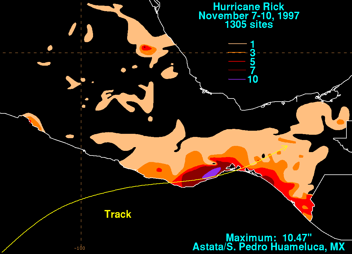
. In Oaxaca, the hurricane was responsible for dumping 10 inches (254 mm) of rain onto the state, which in turn resulted in mudslides and flash floods in areas earlier ravaged by Pauline. These rains also resulted in the sea level rising three feet above normal levels due to high waves generated during its passage. The hurricane was also responsible for rendering bridges and roads unpassable in the state, which had only recently been repaired after they were damaged by two prior hurricanes: 1995's Hurricane Roxanne
in the Atlantic and Pauline, which had weakened bridges a month prior, allowing Rick to topple them, including a bridge near Puerto Escondido which left a 15 feet (4.6 m) deep gap in the road. Among the major roads that were cut off were a mountain road from Puerto Angel to Oaxaca City, a route used to link the coast with Mexico City
, and a route from Puerto Escondido with Acapulco. A total of 10.47 inches (265.9 mm) of rainfall, the highest total caused by Rick, was recorded in Astata/San Pedro Huameluca, which was near the point where the hurricane made landfall. Telephone communications and traffic were cut off to many villages in the wake of the hurricane.
Although Rick was much weaker than Pauline, there were some areas where Rick's impact was greater than that of Pauline's. One such place was the village of El Tomatal, located 10 miles (16.1 km) southeast of Puerto Escondido. There, eight houses were destroyed and roofs were torn off of many others, which residents attributed to more rain than in Pauline, even though the winds were roughly equal.
Although there were no casualties, the hurricane caused more than 2000 people to become homeless. Most of what Pauline had left behind was destroyed by Rick, which one resident said was like "Pauline came to harvest the corn, and Rick came to harvest the peanuts."
In the United States
, Rick had a temporary economic impact when, during its time off the shore of Chiapas and Oaxaca, it caused the price of coffee to rise 4.7 percent to $1.5685 per pound on the Coffee, Sugar and Cocoa Exchange
in New York, the highest total it reached since October 16. Mexico is the United States's largest source of coffee imports and Oaxaca and Chiapas are the largest coffee growing regions in Mexico. Like the impact in El Tomatal, Rick's effects were much worse than Pauline's because Rick threatened the coffee crop when the beans were more susceptible to winds that could blow them off.
in 1957, Tara
in 1961, Iwa
in 1982, Nora in 1991, Sergio
in 2006, and Kenneth in 2011. Rick was the second one of these to make landfall, although it was the third weakest of them, just slightly stronger than Nina and Iwa (Tara's central pressure is unknown). Rick is also the second-latest hurricane in official records to have hit either coast of Mexico, behind only Tara.
1997 Pacific hurricane season
The 1997 Pacific hurricane season was a very active hurricane season. With hundreds of deaths and billions of dollars in damage, this season was the costliest and one of the deadliest Pacific hurricane seasons. This was due to a strong El Niño...
, the last named storm to form in the eastern Pacific, the second-last named storm of the season, and the second latest hurricane ever to make landfall
Landfall (meteorology)
Landfall is the event of a tropical cyclone or a waterspout coming onto land after being over water. When a waterspout makes landfall it is reclassified as a tornado, which can then cause damage inland...
in Mexico
Mexico
The United Mexican States , commonly known as Mexico , is a federal constitutional republic in North America. It is bordered on the north by the United States; on the south and west by the Pacific Ocean; on the southeast by Guatemala, Belize, and the Caribbean Sea; and on the east by the Gulf of...
. Rick was a short-lived Category 2 hurricane on the Saffir-Simpson Hurricane Scale
Saffir-Simpson Hurricane Scale
The Saffir–Simpson Hurricane Scale , or the Saffir–Simpson Hurricane Wind Scale , classifies hurricanes — Western Hemisphere tropical cyclones that exceed the intensities of tropical depressions and tropical storms — into five categories distinguished by the intensities of their sustained winds...
that weakened before making landfall in Mexico on November 10. It hit almost a month after the more powerful Hurricane Pauline
Hurricane Pauline
Hurricane Pauline was one of the strongest and deadliest Pacific hurricanes to make landfall on Mexico. The sixteenth tropical storm, eighth hurricane, and seventh major hurricane of the 1997 Pacific hurricane season, Pauline developed out of a tropical wave on October 5 about 250 miles ...
made landfall in the same country. Most of the damage associated with Pauline was exacerbated by the weaker Rick, which struck during rebuilding efforts.
Damage from Rick was fairly minor. As Rick was heading towards Mexico, the people on the coastline evacuated due to the impact of Pauline making them more prepared to deal with another hurricane, leading to no casualties.
Meteorological history
Hurricane Rick's ultimate origin was a tropical waveTropical wave
Tropical waves, easterly waves, or tropical easterly waves, also known as African easterly waves in the Atlantic region, are a type of atmospheric trough, an elongated area of relatively low air pressure, oriented north to south, which move from east to west across the tropics causing areas of...
that left Africa on October 15. While crossing the Atlantic, the wave was mainly tracked by continuity due to its lack or organization. After entering the Pacific, part of it developed cloudiness on November 5 when it was south of the Gulf of Tehuantepec
Gulf of Tehuantepec
Gulf of Tehuantepec is a large body of water on the Pacific coast of the Isthmus of Tehuantepec, southeastern Mexico, at . Most of the hurricanes that form in the Eastern Pacific organize in or near this body of water...
. Organization and a circulation developed, and satellite tracking began on November 6. The disturbance became better organized and formed into Tropical Depression Nineteen-E on November 7.
At first moving northwest
Boxing the compass
Boxing the compass is the action of naming all thirty-two points of the compass in clockwise order. Such names are formed by the initials of the cardinal directions and their intermediate ordinal directions, and are very handy to refer to a heading in a general or colloquial fashion, without...
, the depression was turned north by a trough
Trough (meteorology)
A trough is an elongated region of relatively low atmospheric pressure, often associated with fronts.Unlike fronts, there is not a universal symbol for a trough on a weather chart. The weather charts in some countries or regions mark troughs by a line. In the United States, a trough may be marked...
. Around noon on November 8, when it was about 375 miles (603.5 km) southwest of Acapulco
Acapulco
Acapulco is a city, municipality and major sea port in the state of Guerrero on the Pacific coast of Mexico, southwest from Mexico City. Acapulco is located on a deep, semi-circular bay and has been a port since the early colonial period of Mexico’s history...
, the depression was upgraded to Tropical Storm Rick. The storm developed a cold central dense overcast, turned northeast, and became a hurricane on November 9. An eye
Eye (cyclone)
The eye is a region of mostly calm weather found at the center of strong tropical cyclones. The eye of a storm is a roughly circular area and typically 30–65 km in diameter. It is surrounded by the eyewall, a ring of towering thunderstorms where the second most severe weather of a cyclone...
appeared that day, accompanied by a well-center visible on Acapulco radar
Weather radar
Weather radar, also called weather surveillance radar and Doppler weather radar, is a type of radar used to locate precipitation, calculate its motion, estimate its type . Modern weather radars are mostly pulse-Doppler radars, capable of detecting the motion of rain droplets in addition to the...
. The hurricane reached its peak intensity of 100 mi/h and 973 mbar, making it a low-end Category 2 on the Saffir-Simpson Hurricane Scale
Saffir-Simpson Hurricane Scale
The Saffir–Simpson Hurricane Scale , or the Saffir–Simpson Hurricane Wind Scale , classifies hurricanes — Western Hemisphere tropical cyclones that exceed the intensities of tropical depressions and tropical storms — into five categories distinguished by the intensities of their sustained winds...
; However, some sources disagree, saying that Rick was a Category 3 major hurricane at its peak. After weakening to 85 mi/h, it made landfall on Oaxaca
Oaxaca
Oaxaca , , officially Estado Libre y Soberano de Oaxaca is one of the 31 states which, along with the Federal District, comprise the 32 federative entities of Mexico. It is divided into 571 municipalities; of which 418 are governed by the system of customs and traditions...
on November 10. Around the time of landfall, hurricane force winds extended 35 miles (56.3 km) and tropical storm force winds extended 115 miles (185.1 km) from the center, respectively. Rick continued to weaken while moving parallel to Mexico's coast along the Gulf of Tehuantepec before dissipating into a convectionless swirl of clouds over Chiapas
Chiapas
Chiapas officially Estado Libre y Soberano de Chiapas is one of the 31 states that, with the Federal District, comprise the 32 Federal Entities of Mexico. It is divided in 118 municipalities and its capital city is Tuxtla Gutierrez. Other important cites in Chiapas include San Cristóbal de las...
on November 11.
Preparations
Lázaro Cárdenas, Michoacán
Lázaro Cárdenas is a port city that with its surrounding municipality is located in the southern part of the Mexican state of Michoacán. It was formerly known as Los Llanitos, but changed its name as a tribute to Lázaro Cárdenas del Río, a Michoacán-born politician who was president of Mexico from...
and Puerto Escondido, Oaxaca. Three hours before Rick was upgraded to a hurricane, the watch was upgraded to a warning and a hurricane watch was issued and shortly afterward raised to a warning. On November 9, the hurricane warning was extended to Zihuatanejo
Zihuatanejo
Zihuatanejo or Ixtapa-Zihuatanejo, is the fourth-largest city in the Mexican state of Guerrero. Politically the city belongs to the municipality of Zihuatanejo de Azueta in the western part of Guerrero, but both are commonly referred to as Zihuatanejo...
and Huatulco
Huatulco
Huatulco , centered on the town of La Crucecita, is a tourist development in Mexico. It is located on the Pacific coast in the state of Oaxaca. Huatulco's tourism industry is centered on its nine bays thus the name Bahias de Huatulco but has since been unofficially shortened to simply Huatulco...
; warnings for areas west of Zihuatanejo and Lázaro Cárdenas were dropped at the same time. However, warnings for areas west of and including Acapulco remained until lifted three hours later. On November 10, warnings were extended from Punta Maldonado to Tapachula
Tapachula
Tapachula is a town and with a hot, humid climate in the Mexican state of Chiapas. It is located in southern part of the state on the Soconusco coastal plain, near the border with Guatemala, at 14.91° N 92.27° W...
; all warnings west of Punta Maldonado were dropped at that time. Then, Mexico's Interior Ministry declared a state of emergency
State of emergency
A state of emergency is a governmental declaration that may suspend some normal functions of the executive, legislative and judicial powers, alert citizens to change their normal behaviours, or order government agencies to implement emergency preparedness plans. It can also be used as a rationale...
along the Oaxaca
Oaxaca
Oaxaca , , officially Estado Libre y Soberano de Oaxaca is one of the 31 states which, along with the Federal District, comprise the 32 federative entities of Mexico. It is divided into 571 municipalities; of which 418 are governed by the system of customs and traditions...
coast. Six hours later, the warnings were downgraded to tropical storm warnings. These warnings remained until they were dropped when Rick was downgraded to a depression.
The people in the coastal areas, most of which were already affected by the more catastrophic Pauline a month ago, were ready for Rick. All major ports along the coast were closed ahead of time in preparation, as well as airports in Huatulco and Puerto Escondido where power failures occurred because of Hurricane Rick. One hundred and thirty Red Cross workers, including twenty that were based in Mexico, who were in the area in the aftermath of Pauline, kept in the area to handle the second hurricane. Many people from Puerto Ángel
Puerto Ángel
Puerto Ángel is a small coastal town in the Mexican state of Oaxaca located in the municipality of San Pedro Pochutla. It, along with San Agustinillo and Playa Zipolite are known as the "Riviera Oaxaqueña. It is located 9 km south of city of Pochutla fifty km west of Huatulco and eighty km...
, Huatulco
Huatulco
Huatulco , centered on the town of La Crucecita, is a tourist development in Mexico. It is located on the Pacific coast in the state of Oaxaca. Huatulco's tourism industry is centered on its nine bays thus the name Bahias de Huatulco but has since been unofficially shortened to simply Huatulco...
, and Puerto Escondido (where National Operations Director Bernardino Heredia was overseeing recovery efforts) beach areas were evacuated. During the Puerto Ángel evacuation, helicopters landed carrying soldier and rifles, which one tourist likened to a third-world revolution. In Chiapas
Chiapas
Chiapas officially Estado Libre y Soberano de Chiapas is one of the 31 states that, with the Federal District, comprise the 32 Federal Entities of Mexico. It is divided in 118 municipalities and its capital city is Tuxtla Gutierrez. Other important cites in Chiapas include San Cristóbal de las...
, officials watched for flooding along the rivers and upstream river valleys, where the rains from three previous systems caused the ground to saturate and in the state capital of Tuxtla Gutiérrez
Tuxtla Gutiérrez
Tuxtla Gutiérrez is the capital and largest city of the Mexican state of Chiapas. It is considered to be the state’s most modern city, with most of its public buildings dating from the 20th century. One exception to this is the San Marcos Cathedral which began as a Dominican parish church built in...
, families were evacuated due to rising rivers.
Impact
Hurricane Pauline
Hurricane Pauline was one of the strongest and deadliest Pacific hurricanes to make landfall on Mexico. The sixteenth tropical storm, eighth hurricane, and seventh major hurricane of the 1997 Pacific hurricane season, Pauline developed out of a tropical wave on October 5 about 250 miles ...
. In Oaxaca, the hurricane was responsible for dumping 10 inches (254 mm) of rain onto the state, which in turn resulted in mudslides and flash floods in areas earlier ravaged by Pauline. These rains also resulted in the sea level rising three feet above normal levels due to high waves generated during its passage. The hurricane was also responsible for rendering bridges and roads unpassable in the state, which had only recently been repaired after they were damaged by two prior hurricanes: 1995's Hurricane Roxanne
Hurricane Roxanne
Hurricane Roxanne caused extensive flooding in Mexico due to its erratic movement. The seventeenth storm, tenth hurricane, and the fifth and final major hurricane of the very active 1995 Atlantic hurricane season, Roxanne developed in the southwestern Caribbean Sea from an area of low pressure on...
in the Atlantic and Pauline, which had weakened bridges a month prior, allowing Rick to topple them, including a bridge near Puerto Escondido which left a 15 feet (4.6 m) deep gap in the road. Among the major roads that were cut off were a mountain road from Puerto Angel to Oaxaca City, a route used to link the coast with Mexico City
Mexico City
Mexico City is the Federal District , capital of Mexico and seat of the federal powers of the Mexican Union. It is a federal entity within Mexico which is not part of any one of the 31 Mexican states but belongs to the federation as a whole...
, and a route from Puerto Escondido with Acapulco. A total of 10.47 inches (265.9 mm) of rainfall, the highest total caused by Rick, was recorded in Astata/San Pedro Huameluca, which was near the point where the hurricane made landfall. Telephone communications and traffic were cut off to many villages in the wake of the hurricane.
Although Rick was much weaker than Pauline, there were some areas where Rick's impact was greater than that of Pauline's. One such place was the village of El Tomatal, located 10 miles (16.1 km) southeast of Puerto Escondido. There, eight houses were destroyed and roofs were torn off of many others, which residents attributed to more rain than in Pauline, even though the winds were roughly equal.
Although there were no casualties, the hurricane caused more than 2000 people to become homeless. Most of what Pauline had left behind was destroyed by Rick, which one resident said was like "Pauline came to harvest the corn, and Rick came to harvest the peanuts."
In the United States
United States
The United States of America is a federal constitutional republic comprising fifty states and a federal district...
, Rick had a temporary economic impact when, during its time off the shore of Chiapas and Oaxaca, it caused the price of coffee to rise 4.7 percent to $1.5685 per pound on the Coffee, Sugar and Cocoa Exchange
Coffee, Sugar and Cocoa Exchange
The Coffee, Sugar and Cocoa Exchange was founded in 1882 as the Coffee Exchange in the City of New York. Sugar futures were added in 1914, and, on September 28, 1979, the New York Coffee and Sugar Exchange merged with the New York Cocoa Exchange to form CSCE...
in New York, the highest total it reached since October 16. Mexico is the United States's largest source of coffee imports and Oaxaca and Chiapas are the largest coffee growing regions in Mexico. Like the impact in El Tomatal, Rick's effects were much worse than Pauline's because Rick threatened the coffee crop when the beans were more susceptible to winds that could blow them off.
Records
Rick was one of only seven known hurricanes to form in the East Pacific in November. The others were NinaHurricane Nina (1957)
Hurricane Nina was the final tropical storm and hurricane of the 1957 Pacific hurricane season and the last storm to form during the active Central Pacific hurricane season this year. This storm was named "Nina" because during this time, hurricanes in this basin were given names from the typhoon...
in 1957, Tara
Hurricane Tara (1961)
Hurricane Tara, also known as Cyclone Tara, was one of the deadliest Pacific hurricanes on record. The final tropical cyclone of the 1961 Pacific hurricane season, Tara formed on November 10 about 230 mi off the coast of Mexico...
in 1961, Iwa
Hurricane Iwa
Hurricane Iwa, taken from the Hawaiian language name for the frigatebird , was at the time the costliest hurricane to affect the state of Hawaii. Iwa was the twenty-third tropical storm and the twelfth and final hurricane of the 1982 Pacific hurricane season. It developed from an active trough of...
in 1982, Nora in 1991, Sergio
Hurricane Sergio (2006)
Hurricane Sergio was the second strongest Pacific hurricane in the month of November on record, just after 2011's Kenneth. The nineteenth named storm and eleventh hurricane of the 2006 Pacific hurricane season, Sergio developed from a tropical wave on November 13 about 460 miles south of...
in 2006, and Kenneth in 2011. Rick was the second one of these to make landfall, although it was the third weakest of them, just slightly stronger than Nina and Iwa (Tara's central pressure is unknown). Rick is also the second-latest hurricane in official records to have hit either coast of Mexico, behind only Tara.
See also
- List of Pacific hurricanes
- Timeline of the 1997 Pacific hurricane seasonTimeline of the 1997 Pacific hurricane seasonThe 1997 Pacific hurricane season was the most active season since the 1994 season, producing 24 tropical depressions, 19 of which became tropical storms or hurricanes. The season officially started on May 15, 1997 in the Eastern Pacific—designated as the area east of 140°W—and on June 1, 1997...
- Hurricane PaulineHurricane PaulineHurricane Pauline was one of the strongest and deadliest Pacific hurricanes to make landfall on Mexico. The sixteenth tropical storm, eighth hurricane, and seventh major hurricane of the 1997 Pacific hurricane season, Pauline developed out of a tropical wave on October 5 about 250 miles ...
- 1997 Pacific hurricane season1997 Pacific hurricane seasonThe 1997 Pacific hurricane season was a very active hurricane season. With hundreds of deaths and billions of dollars in damage, this season was the costliest and one of the deadliest Pacific hurricane seasons. This was due to a strong El Niño...
- Other storms with the same nameTropical Storm RickThe name Rick has been used for three tropical cyclones in the Eastern Pacific Ocean and one tropical cyclone in the Western Pacific.It is used on the six-year lists in the Eastern Pacific:...