
Hurricane Iwa
Encyclopedia
Hurricane Iwa, taken from the Hawaiian language
name for the frigatebird
(iwa, lit. "Thief"), was at the time the costliest hurricane to affect the state of Hawaii
. Iwa was the twenty-third tropical storm and the twelfth and final hurricane of the 1982 Pacific hurricane season
. It developed from an active trough
of low pressure near the equator
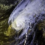
on November 19. The storm moved erratically northward until becoming a hurricane on November 23 when it began accelerating to the northeast in response to strong upper-level flow from the north. Iwa passed within 25 miles of the island of Kauai
with peak winds of 90 mph (145 km/h) on November 23 (November 24 Coordinated Universal Time
), and the next day it became extratropical
to the northeast of the state.
The hurricane devastated the islands of Niihau
, Kauai
, and Oahu
with wind gusts exceeding 100 mph (160 km/h) and rough seas exceeding 30 feet (9 m) in height. The first significant hurricane to hit the Hawaiian Islands
since statehood in 1959, Iwa severely damaged or destroyed 2,345 buildings, including 1,927 houses, leaving 500 people homeless. Damage throughout the state totaled $312 million (1982 USD, $ USD
). One person was killed from the high seas, and three deaths were indirectly related to the hurricane's aftermath.
of low pressure persisted along the equator
in the middle of November, with westerly surface winds and windspread convection located along the trough from 140° W to 140° E. An organized circulation developed near Palmyra Atoll
on November 18, and steadily developed as it drifted westward. Though very late in the season, warm temperatures to the south of the Hawaiian Islands
due to the strongest El Nino in many years allowed the disturbance to develop into Tropical Storm Iwa on November 19 while located about 970 miles (1,760 km) southwest of the southernmost point in Hawaii
. The storm tracked slowly northward after forming and initially remained a weak tropical storm. After turning to the northeast, Iwa began slowly intensifying, and on November 23 after turning to the north-northwest Iwa strengthened into a hurricane while located 580 miles (930 km) southwest of the southern tip of Hawaii.
Shortly after becoming a hurricane, Iwa turned and accelerated to the northeast in response to strong upper level flow to its north. The hurricane possessed sufficient moisture, instability, and upper divergence for continued intensification, and Iwa reached peak winds of 90 mph (145 km/h) late on November 23 while located 245 miles (395 km) southwest of Waimea
on the island of Kauai
. Its forward speed increased to 30 to 40 mph, and Iwa passed just north of the island of Kauai on November 23 (November 24 in UTC). The right semicircle of the storm extended across Kauai and Oahu
, with gusts from 100 to 120 mph (161 to 193 km/h). After passing Hawaii
, the convection of Iwa rapidly deteriorated as it gradually lost tropical characteristics
. Late on November 24, the hurricane degenerated into a tropical storm, and on November 25 Iwa became an extratropical cyclone
while located about 600 miles (965 km) northeast of Hawaii.
and Oahu
. The acceleration of the hurricane concentrated the energy of its swells, resulting in high waves and storm surge
across the Hawaiian Islands, though primarily near the path of the center. It is estimated the storm surge reached eight feet (two meters) on the south coast of Kauai. There, the surge reached 900 feet (275 m) inland, exceeding a 100-year flood
event for the area. The heaviest rainfall reported from the island chain was from the Intake Wainiha 1086 site, where 20.33 inches (516 mm) was measured. Possible tornadoes were reported in association with a rain squall in Oahu. Waves on the coast of Oahu reached 16.4 feet in height (3 m), and waves on southern Kauai surpassed 30 feet (9 m) in height.
During the worst of the storm, 5,800 people were evacuated from shoreline areas of Kauai
to temporary shelters. Strong waves sank or grounded several small vessels on the southwestern coast of Kauai, with 44 of the 45 boats at Port Allen
being sunk. The worst of the damage from the hurricane occurred in Poipu
, where the rough surf destroyed or severely damaged several exposed luxury hotels and condominiums. Elsewhere on the island, damage was greatest in areas where there was no protective barrier reef offshore. Several small aircraft were damaged at Lihue airport from the winds, including many overturned small planes. The winds destroyed several buildings across the island, including one of Kauai's oldest churches and a warehouse. Additionally, the winds destroyed the roof of a bank. Strong winds initially left the entire island of Kauai without power. Highway 56 on the east side of the island was obstructed by fallen telephone poles, forcing residents to drive on the unpaved, red dirt cane roads usually reserved for hauling sugar cane from the fields. Rising waters washed out multiple roads near the coastline. The strong winds destroyed nearly all papaya
and banyan
trees on the island. The hurricane destroyed or greatly damaged 1,907 homes on the island and caused minor damage to 2,983 others, leaving one-eighth of the island's homes unlivable.
Rough seas killed a person on a Navy Destroyer the USS Goldsborough DDG-20 in Pearl Harbor
when the seaman hit a stanchion
, with four others injured on the ship. One of the four injured was swept overboard two miles (three kilometers) from the harbor. Prior to the arrival of the hurricane, around 1,000 evacuated the low-lying coastline to shelters.
Rough waves destroyed four and damaged two deep-water communication cables
between Oahu and Kauai. In Oahu
, damage from wind and surf was heaviest on the southwest coast between Nānākuli
and Mākaha
. The storm surge washed sand into streets in Waikīkī
and flooded cars in areas of basement parking. Wind damage was greatest in areas where winds blew from southerly directions off of mountains. The winds damaged several small aircraft and a Douglas DC-3
plane in Honolulu
. Gusty winds shattered glass windows in the Honolulu International Airport
, injuring several passengers. Some flights in and out of the Honolulu airport were delayed, while other domestic airports were temporarily closed. The passage of the hurricane damaged at least 6,391 homes, 21 hotels, and two condominium buildings on the island. Additionally, 418 buildings, including 30 businesses, were destroyed on Oahu.
Surf damage was reported throughout the Hawaiian islands. 120 people were treated for injuries, though most were minor. An estimated 500 people throughout Hawaii were left homeless due to the hurricane. Damage on the private island of Niihau
was severe. An aerial survey indicated 20 homes were destroyed and 160 were damaged, indicating that the hurricane affected nearly all of the island's 226 residents. Reportedly no one was injured on Niihau. At the time, Hurricane Iwa was the costliest storm to hit the state of Hawaii, with damage totaling $312 million (1982 USD, $ USD
).
George Ariyoshi
declared the islands of Kauai and Niihau as disaster areas and began filing papers for a federal disaster declaration. On November 28, five days after the hurricane struck, President
Ronald Reagan
declared the islands of Kauai, Niihau, and Oahu as a disaster area. The declaration allocated federal funds to aid the affected citizens. The state Department of Education decided to close all schools on Kauai indefinitely.
The thousands of Hawaiians without power celebrated Thanksgiving
by cooking turkeys on outdoor grills or smokers. Army
and Air Force
planes delivered 20,000 Thanksgiving rations to the thousands left in temporary shelters. The United States military also airlifted generators to Kauai due to several days of power outages. By a week after the hurricane, utility crews restored power to nearly all major areas in Oahu, while 5,000 remained without power in Kauai. By around a month after the hurricane passed the island, utilities were restored to most of the entire island. All roads and highways were cleared, as well. One 25th Infantry Division soldier at Schofield Barracks died while cleaning up after the hurricane. Two people died in a traffic accident due to malfunctioning traffic lights. Following the storm, significant redevelopment occurred in Poipu
, where the hurricane flooded areas several hundred feet inland. Hurricane Iniki
struck the same area ten years later. Officials estimate a hurricane similar to Iwa striking Oahu in 1992 could cause up to $7.5 billion in damage (USD).
The Central Pacific Hurricane Center
retired the name Iwa subsequent to the storm and replaced it with Io. Due to low amounts of tropical activity in the central Pacific Ocean
, the name Io has not since been used. Iwa was the first retired hurricane in the Central Pacific since the modern system of using Hawaiian naming began in the early 1980s, and it remains one of only four to be retired as of 2007.
Hawaiian language
The Hawaiian language is a Polynesian language that takes its name from Hawaii, the largest island in the tropical North Pacific archipelago where it developed. Hawaiian, along with English, is an official language of the state of Hawaii...
name for the frigatebird
Frigatebird
The frigatebirds are a family, Fregatidae, of seabirds. There are five species in the single genus Fregata. They are also sometimes called Man of War birds or Pirate birds. Since they are related to the pelicans, the term "frigate pelican" is also a name applied to them...
(iwa, lit. "Thief"), was at the time the costliest hurricane to affect the state of Hawaii
Hawaii
Hawaii is the newest of the 50 U.S. states , and is the only U.S. state made up entirely of islands. It is the northernmost island group in Polynesia, occupying most of an archipelago in the central Pacific Ocean, southwest of the continental United States, southeast of Japan, and northeast of...
. Iwa was the twenty-third tropical storm and the twelfth and final hurricane of the 1982 Pacific hurricane season
1982 Pacific hurricane season
The 1982 Pacific hurricane season officially started May 15, 1982 in the eastern Pacific, and June 1, 1982 in the central Pacific, and lasted until November 30, 1982. These dates conventionally delimit the period of each year when most tropical cyclones form in the northeastern Pacific Ocean.The...
. It developed from an active trough
Trough (meteorology)
A trough is an elongated region of relatively low atmospheric pressure, often associated with fronts.Unlike fronts, there is not a universal symbol for a trough on a weather chart. The weather charts in some countries or regions mark troughs by a line. In the United States, a trough may be marked...
of low pressure near the equator
Equator
An equator is the intersection of a sphere's surface with the plane perpendicular to the sphere's axis of rotation and containing the sphere's center of mass....
on November 19. The storm moved erratically northward until becoming a hurricane on November 23 when it began accelerating to the northeast in response to strong upper-level flow from the north. Iwa passed within 25 miles of the island of Kauai
Kauai
Kauai or Kauai, known as Tauai in the ancient Kaua'i dialect, is geologically the oldest of the main Hawaiian Islands. With an area of , it is the fourth largest of the main islands in the Hawaiian archipelago, and the 21st largest island in the United States. Known also as the "Garden Isle",...
with peak winds of 90 mph (145 km/h) on November 23 (November 24 Coordinated Universal Time
Coordinated Universal Time
Coordinated Universal Time is the primary time standard by which the world regulates clocks and time. It is one of several closely related successors to Greenwich Mean Time. Computer servers, online services and other entities that rely on having a universally accepted time use UTC for that purpose...
), and the next day it became extratropical
Extratropical cyclone
Extratropical cyclones, sometimes called mid-latitude cyclones or wave cyclones, are a group of cyclones defined as synoptic scale low pressure weather systems that occur in the middle latitudes of the Earth having neither tropical nor polar characteristics, and are connected with fronts and...
to the northeast of the state.
The hurricane devastated the islands of Niihau
Niihau
Niihau or Niihau is the seventh largest of the inhabited Hawaiian Islands in the U.S. state of Hawaii, having an area of . Niihau lies southwest of Kauai across the Kaulakahi Channel. Several intermittent playa lakes provide wetland habitats for the Hawaiian Coot, the Black-winged Stilt, and the...
, Kauai
Kauai
Kauai or Kauai, known as Tauai in the ancient Kaua'i dialect, is geologically the oldest of the main Hawaiian Islands. With an area of , it is the fourth largest of the main islands in the Hawaiian archipelago, and the 21st largest island in the United States. Known also as the "Garden Isle",...
, and Oahu
Oahu
Oahu or Oahu , known as "The Gathering Place", is the third largest of the Hawaiian Islands and most populous of the islands in the U.S. state of Hawaii. The state capital Honolulu is located on the southeast coast...
with wind gusts exceeding 100 mph (160 km/h) and rough seas exceeding 30 feet (9 m) in height. The first significant hurricane to hit the Hawaiian Islands
Hawaiian Islands
The Hawaiian Islands are an archipelago of eight major islands, several atolls, numerous smaller islets, and undersea seamounts in the North Pacific Ocean, extending some 1,500 miles from the island of Hawaii in the south to northernmost Kure Atoll...
since statehood in 1959, Iwa severely damaged or destroyed 2,345 buildings, including 1,927 houses, leaving 500 people homeless. Damage throughout the state totaled $312 million (1982 USD, $ USD
United States dollar
The United States dollar , also referred to as the American dollar, is the official currency of the United States of America. It is divided into 100 smaller units called cents or pennies....
). One person was killed from the high seas, and three deaths were indirectly related to the hurricane's aftermath.
Meteorological history
A very active troughTrough (meteorology)
A trough is an elongated region of relatively low atmospheric pressure, often associated with fronts.Unlike fronts, there is not a universal symbol for a trough on a weather chart. The weather charts in some countries or regions mark troughs by a line. In the United States, a trough may be marked...
of low pressure persisted along the equator
Equator
An equator is the intersection of a sphere's surface with the plane perpendicular to the sphere's axis of rotation and containing the sphere's center of mass....
in the middle of November, with westerly surface winds and windspread convection located along the trough from 140° W to 140° E. An organized circulation developed near Palmyra Atoll
Palmyra Atoll
Palmyra Atoll is an essentially unoccupied equatorial Northern Pacific atoll administered as an unorganized incorporated territory by the United States federal government...
on November 18, and steadily developed as it drifted westward. Though very late in the season, warm temperatures to the south of the Hawaiian Islands
Hawaiian Islands
The Hawaiian Islands are an archipelago of eight major islands, several atolls, numerous smaller islets, and undersea seamounts in the North Pacific Ocean, extending some 1,500 miles from the island of Hawaii in the south to northernmost Kure Atoll...
due to the strongest El Nino in many years allowed the disturbance to develop into Tropical Storm Iwa on November 19 while located about 970 miles (1,760 km) southwest of the southernmost point in Hawaii
Ka Lae
Ka Lae , also known as South Point, is the southernmost point of the Big Island of Hawaii and of the 50 United States. The Ka Lae area is registered as a National Historic Landmark District under the name South Point Complex...
. The storm tracked slowly northward after forming and initially remained a weak tropical storm. After turning to the northeast, Iwa began slowly intensifying, and on November 23 after turning to the north-northwest Iwa strengthened into a hurricane while located 580 miles (930 km) southwest of the southern tip of Hawaii.
Shortly after becoming a hurricane, Iwa turned and accelerated to the northeast in response to strong upper level flow to its north. The hurricane possessed sufficient moisture, instability, and upper divergence for continued intensification, and Iwa reached peak winds of 90 mph (145 km/h) late on November 23 while located 245 miles (395 km) southwest of Waimea
Waimea, Kauai County, Hawaii
Waimea is a census-designated place in Kauai County, Hawaii, United States. The population was 1,787 at the 2000 census...
on the island of Kauai
Kauai
Kauai or Kauai, known as Tauai in the ancient Kaua'i dialect, is geologically the oldest of the main Hawaiian Islands. With an area of , it is the fourth largest of the main islands in the Hawaiian archipelago, and the 21st largest island in the United States. Known also as the "Garden Isle",...
. Its forward speed increased to 30 to 40 mph, and Iwa passed just north of the island of Kauai on November 23 (November 24 in UTC). The right semicircle of the storm extended across Kauai and Oahu
Oahu
Oahu or Oahu , known as "The Gathering Place", is the third largest of the Hawaiian Islands and most populous of the islands in the U.S. state of Hawaii. The state capital Honolulu is located on the southeast coast...
, with gusts from 100 to 120 mph (161 to 193 km/h). After passing Hawaii
Hawaii
Hawaii is the newest of the 50 U.S. states , and is the only U.S. state made up entirely of islands. It is the northernmost island group in Polynesia, occupying most of an archipelago in the central Pacific Ocean, southwest of the continental United States, southeast of Japan, and northeast of...
, the convection of Iwa rapidly deteriorated as it gradually lost tropical characteristics
Tropical cyclone
A tropical cyclone is a storm system characterized by a large low-pressure center and numerous thunderstorms that produce strong winds and heavy rain. Tropical cyclones strengthen when water evaporated from the ocean is released as the saturated air rises, resulting in condensation of water vapor...
. Late on November 24, the hurricane degenerated into a tropical storm, and on November 25 Iwa became an extratropical cyclone
Extratropical cyclone
Extratropical cyclones, sometimes called mid-latitude cyclones or wave cyclones, are a group of cyclones defined as synoptic scale low pressure weather systems that occur in the middle latitudes of the Earth having neither tropical nor polar characteristics, and are connected with fronts and...
while located about 600 miles (965 km) northeast of Hawaii.
Impact
Hurricane Iwa produced estimated gusts reaching 120 mph (193 km/h) across KauaiKauai
Kauai or Kauai, known as Tauai in the ancient Kaua'i dialect, is geologically the oldest of the main Hawaiian Islands. With an area of , it is the fourth largest of the main islands in the Hawaiian archipelago, and the 21st largest island in the United States. Known also as the "Garden Isle",...
and Oahu
Oahu
Oahu or Oahu , known as "The Gathering Place", is the third largest of the Hawaiian Islands and most populous of the islands in the U.S. state of Hawaii. The state capital Honolulu is located on the southeast coast...
. The acceleration of the hurricane concentrated the energy of its swells, resulting in high waves and storm surge
Storm surge
A storm surge is an offshore rise of water associated with a low pressure weather system, typically tropical cyclones and strong extratropical cyclones. Storm surges are caused primarily by high winds pushing on the ocean's surface. The wind causes the water to pile up higher than the ordinary sea...
across the Hawaiian Islands, though primarily near the path of the center. It is estimated the storm surge reached eight feet (two meters) on the south coast of Kauai. There, the surge reached 900 feet (275 m) inland, exceeding a 100-year flood
100-year flood
A one-hundred-year flood is calculated to be the level of flood water expected to be equaled or exceeded every 100 years on average. The 100-year flood is more accurately referred to as the 1% annual exceedance probability flood, since it is a flood that has a 1% chance of being equaled or exceeded...
event for the area. The heaviest rainfall reported from the island chain was from the Intake Wainiha 1086 site, where 20.33 inches (516 mm) was measured. Possible tornadoes were reported in association with a rain squall in Oahu. Waves on the coast of Oahu reached 16.4 feet in height (3 m), and waves on southern Kauai surpassed 30 feet (9 m) in height.
During the worst of the storm, 5,800 people were evacuated from shoreline areas of Kauai
Kauai
Kauai or Kauai, known as Tauai in the ancient Kaua'i dialect, is geologically the oldest of the main Hawaiian Islands. With an area of , it is the fourth largest of the main islands in the Hawaiian archipelago, and the 21st largest island in the United States. Known also as the "Garden Isle",...
to temporary shelters. Strong waves sank or grounded several small vessels on the southwestern coast of Kauai, with 44 of the 45 boats at Port Allen
Port Allen Airport
Port Allen Airport is a regional airport of the State of Hawai'i. It is located southwest of the unincorporated town of Hanapepe on the south shore of the island of Kaua'i...
being sunk. The worst of the damage from the hurricane occurred in Poipu
Poipu, Hawaii
Poipū is a census-designated place in Kauai County on the southern side of the island of Kauai in the U.S. state of Hawaii. The population was 1,075 at the 2000 census...
, where the rough surf destroyed or severely damaged several exposed luxury hotels and condominiums. Elsewhere on the island, damage was greatest in areas where there was no protective barrier reef offshore. Several small aircraft were damaged at Lihue airport from the winds, including many overturned small planes. The winds destroyed several buildings across the island, including one of Kauai's oldest churches and a warehouse. Additionally, the winds destroyed the roof of a bank. Strong winds initially left the entire island of Kauai without power. Highway 56 on the east side of the island was obstructed by fallen telephone poles, forcing residents to drive on the unpaved, red dirt cane roads usually reserved for hauling sugar cane from the fields. Rising waters washed out multiple roads near the coastline. The strong winds destroyed nearly all papaya
Papaya
The papaya , papaw, or pawpaw is the fruit of the plant Carica papaya, the sole species in the genus Carica of the plant family Caricaceae...
and banyan
Banyan
A banyan is a fig that starts its life as an epiphyte when its seeds germinate in the cracks and crevices on a host tree...
trees on the island. The hurricane destroyed or greatly damaged 1,907 homes on the island and caused minor damage to 2,983 others, leaving one-eighth of the island's homes unlivable.
Rough seas killed a person on a Navy Destroyer the USS Goldsborough DDG-20 in Pearl Harbor
Pearl Harbor
Pearl Harbor, known to Hawaiians as Puuloa, is a lagoon harbor on the island of Oahu, Hawaii, west of Honolulu. Much of the harbor and surrounding lands is a United States Navy deep-water naval base. It is also the headquarters of the U.S. Pacific Fleet...
when the seaman hit a stanchion
Stanchion
A stanchion is an upright bar or post, often providing support for some other object.* An architectural term applied to the upright iron bars in windows that pass through the eyes of the saddle bars or horizontal irons to steady the leadlight. A stanchion is an upright bar or post, often...
, with four others injured on the ship. One of the four injured was swept overboard two miles (three kilometers) from the harbor. Prior to the arrival of the hurricane, around 1,000 evacuated the low-lying coastline to shelters.
Rough waves destroyed four and damaged two deep-water communication cables
Southern Cross Cable
The Southern Cross Cable, operated by Bermuda company Southern Cross Cables Limited, is a trans-Pacific network of telecommunications cables commissioned in 2000....
between Oahu and Kauai. In Oahu
Oahu
Oahu or Oahu , known as "The Gathering Place", is the third largest of the Hawaiian Islands and most populous of the islands in the U.S. state of Hawaii. The state capital Honolulu is located on the southeast coast...
, damage from wind and surf was heaviest on the southwest coast between Nānākuli
Nanakuli, Hawai'i
Nānākuli is a census-designated place in the Waianae District on the Island of Oahu, City & County of Honolulu, Hawaii, United States. In Hawaiian, nānā kuli means literally "look at knee". The population was 10,814 at the 2000 census.- Geography :...
and Mākaha
Makaha, Hawai'i
thumb|280px|Historically, Mākaha was an [[ahupua'a|ahupuaʻa]], or area of land ruled by chief or king and managed by the members of the [[alii|alii]]Mākaha is a census-designated place in Honolulu County, Hawaii, United States...
. The storm surge washed sand into streets in Waikīkī
Waikiki
Waikiki is a neighborhood of Honolulu, in the City and County of Honolulu, on the south shore of the island of Oahu, in Hawaii. Waikiki Beach is the shoreline fronting Waikīkī....
and flooded cars in areas of basement parking. Wind damage was greatest in areas where winds blew from southerly directions off of mountains. The winds damaged several small aircraft and a Douglas DC-3
Douglas DC-3
The Douglas DC-3 is an American fixed-wing propeller-driven aircraft whose speed and range revolutionized air transport in the 1930s and 1940s. Its lasting impact on the airline industry and World War II makes it one of the most significant transport aircraft ever made...
plane in Honolulu
Honolulu, Hawaii
Honolulu is the capital and the most populous city of the U.S. state of Hawaii. Honolulu is the southernmost major U.S. city. Although the name "Honolulu" refers to the urban area on the southeastern shore of the island of Oahu, the city and county government are consolidated as the City and...
. Gusty winds shattered glass windows in the Honolulu International Airport
Honolulu International Airport
Honolulu International Airport is the principal aviation gateway of the City & County of Honolulu and the State of Hawaii and is identified as one of the busiest airports in the United States, with traffic now exceeding 21 million passengers a year and rising.It is located in the Honolulu...
, injuring several passengers. Some flights in and out of the Honolulu airport were delayed, while other domestic airports were temporarily closed. The passage of the hurricane damaged at least 6,391 homes, 21 hotels, and two condominium buildings on the island. Additionally, 418 buildings, including 30 businesses, were destroyed on Oahu.
Surf damage was reported throughout the Hawaiian islands. 120 people were treated for injuries, though most were minor. An estimated 500 people throughout Hawaii were left homeless due to the hurricane. Damage on the private island of Niihau
Niihau
Niihau or Niihau is the seventh largest of the inhabited Hawaiian Islands in the U.S. state of Hawaii, having an area of . Niihau lies southwest of Kauai across the Kaulakahi Channel. Several intermittent playa lakes provide wetland habitats for the Hawaiian Coot, the Black-winged Stilt, and the...
was severe. An aerial survey indicated 20 homes were destroyed and 160 were damaged, indicating that the hurricane affected nearly all of the island's 226 residents. Reportedly no one was injured on Niihau. At the time, Hurricane Iwa was the costliest storm to hit the state of Hawaii, with damage totaling $312 million (1982 USD, $ USD
United States dollar
The United States dollar , also referred to as the American dollar, is the official currency of the United States of America. It is divided into 100 smaller units called cents or pennies....
).
Aftermath
Three days after Hurricane Iwa passed the state, GovernorGovernor of Hawaii
The Governor of Hawaii is the chief executive of the state of Hawaii and its various agencies and departments, as provided in the Hawaii State Constitution Article V, Sections 1 through 6. It is a directly elected position, votes being cast by popular suffrage of residents of the state...
George Ariyoshi
George Ariyoshi
George Ryoichi Ariyoshi , served as the third Governor of Hawaii from 1974 to 1986. He is a member of the Democratic Party. He assumed the governorship when John A. Burns was declared incapacitated. When he was elected, Ariyoshi became the first American of Asian descent to be elected governor of...
declared the islands of Kauai and Niihau as disaster areas and began filing papers for a federal disaster declaration. On November 28, five days after the hurricane struck, President
President of the United States
The President of the United States of America is the head of state and head of government of the United States. The president leads the executive branch of the federal government and is the commander-in-chief of the United States Armed Forces....
Ronald Reagan
Ronald Reagan
Ronald Wilson Reagan was the 40th President of the United States , the 33rd Governor of California and, prior to that, a radio, film and television actor....
declared the islands of Kauai, Niihau, and Oahu as a disaster area. The declaration allocated federal funds to aid the affected citizens. The state Department of Education decided to close all schools on Kauai indefinitely.
The thousands of Hawaiians without power celebrated Thanksgiving
Thanksgiving
Thanksgiving Day is a holiday celebrated primarily in the United States and Canada. Thanksgiving is celebrated each year on the second Monday of October in Canada and on the fourth Thursday of November in the United States. In Canada, Thanksgiving falls on the same day as Columbus Day in the...
by cooking turkeys on outdoor grills or smokers. Army
United States Army
The United States Army is the main branch of the United States Armed Forces responsible for land-based military operations. It is the largest and oldest established branch of the U.S. military, and is one of seven U.S. uniformed services...
and Air Force
United States Air Force
The United States Air Force is the aerial warfare service branch of the United States Armed Forces and one of the American uniformed services. Initially part of the United States Army, the USAF was formed as a separate branch of the military on September 18, 1947 under the National Security Act of...
planes delivered 20,000 Thanksgiving rations to the thousands left in temporary shelters. The United States military also airlifted generators to Kauai due to several days of power outages. By a week after the hurricane, utility crews restored power to nearly all major areas in Oahu, while 5,000 remained without power in Kauai. By around a month after the hurricane passed the island, utilities were restored to most of the entire island. All roads and highways were cleared, as well. One 25th Infantry Division soldier at Schofield Barracks died while cleaning up after the hurricane. Two people died in a traffic accident due to malfunctioning traffic lights. Following the storm, significant redevelopment occurred in Poipu
Poipu, Hawaii
Poipū is a census-designated place in Kauai County on the southern side of the island of Kauai in the U.S. state of Hawaii. The population was 1,075 at the 2000 census...
, where the hurricane flooded areas several hundred feet inland. Hurricane Iniki
Hurricane Iniki
Hurricane Iniki was the most powerful hurricane to strike the U.S. state of Hawaii in recorded history. Forming on September 5 during the strong El Niño of 1991–1994, Iniki was one of eleven Central Pacific tropical cyclones during the 1992 season. It attained tropical storm status on...
struck the same area ten years later. Officials estimate a hurricane similar to Iwa striking Oahu in 1992 could cause up to $7.5 billion in damage (USD).
The Central Pacific Hurricane Center
Central Pacific Hurricane Center
The Central Pacific Hurricane Center of the United States National Weather Service is the official body responsible for tracking and issuing tropical cyclone warnings, watches, advisories, discussions, and statements for the Central North Pacific Basin...
retired the name Iwa subsequent to the storm and replaced it with Io. Due to low amounts of tropical activity in the central Pacific Ocean
Pacific Ocean
The Pacific Ocean is the largest of the Earth's oceanic divisions. It extends from the Arctic in the north to the Southern Ocean in the south, bounded by Asia and Australia in the west, and the Americas in the east.At 165.2 million square kilometres in area, this largest division of the World...
, the name Io has not since been used. Iwa was the first retired hurricane in the Central Pacific since the modern system of using Hawaiian naming began in the early 1980s, and it remains one of only four to be retired as of 2007.
See also
- List of Pacific hurricanes
- List of Hawaii hurricanes
- List of retired Pacific hurricane names