
Hurricane Isbell
Encyclopedia
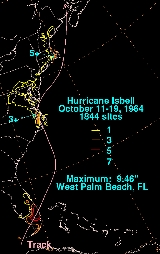
Hurricane Isbell was the strongest U.S. landfalling hurricane of the 1964 Atlantic hurricane season
. It became a tropical depression east of Nicaragua
on October 8. It then strengthened into a tropical storm and later into a hurricane on October 13 before making landfall in western Cuba
. In the Gulf of Mexico, on October 14, it strengthened into a major hurricane before making landfall in southwest Florida
as a Category 2 hurricane. After entering the Atlantic
, it headed towards North Carolina and made landfall on October 16 just before weakening to an extratropical storm with winds under hurricane force at 45 mph (70 km/h). It then dissipated the following day. It caused $20 million (1964 USD) ($120 million in 2005 USD) in damage, most of it being from crop damage or tornadic
activity. In addition to damage, it caused 6 deaths.
in early October. Evidence of a tropical disturbance originated over the western Caribbean during October 7 and October 8 at the very end of this frontal trough. The system developed and a weak tropical depression formed on October 8 as it started to move slowly to the northwest. On October 12, it stalled its northwestern progress and made a small loop, followed by a northeastward turn. Lack of inflow and possible earlier land interaction kept the depression fairly weak, but it was able to strengthen 5 mph (10 km/h) further from its original strength later that day, and then reached tropical storm strength on October 13 and was designated as Tropical Storm Isbell.
Isbell reached hurricane intensity around 18 UTC
on October 13 shortly after reaching tropical storm status earlier that day. A few hours after being upgraded, the storm made landfall in the extreme western portion of Cuba. It then crossed western Cuba
, entered the southeast Gulf of Mexico, and began to strengthen into a Category 3
hurricane.
Isbell reached its peak strength, with winds of 125 mph (205 km/h), southwest of Key West
. Subsequently, Isbell weakened and made landfall in Florida near Everglades City as a Category 2 hurricane on October 14. Maintaining intensity across the southern Florida peninsula, Isbell maintained hurricane status as it reached the western Atlantic
that night, but the storm began to steadily weaken while moving north. It maintained its hurricane force winds until October 16. Isbell became extratropical, with winds of 45 mph (70 km/h), shortly before its final landfall near Morehead City, North Carolina
on October 16, and dissipated the next day after moving inland.
Numerous hurricane warnings and watches were issued prior to landfall in Florida. Advisories were broadcast and issued warning of the possibility of heavy rains and winds, isolated small hail, and possible isolated tornadoes from 4 to 10 PM CST October 14, 1964. The aviation severe weather forecast also notified people that within an area south and east of a line from sixty miles southwest of Miami
north to Gainesville
, as well as to 40 miles north of Daytona Beach
, 3/4 inch maximum hail, gusts of up to 85 km/h, and one to two tornadoes were possible on October 14. Flood warnings were also issued, with predictions of flooding 4 feet above flood stage. Emergency preparations at Key West
's weather office were made. On October 13, 1964, in the morning hours the office alerted city, county, and military officials. In the afternoon, they completed office preparations and scheduling, they also checked equipment. Later, gale warning
s and hurricane watches were issued for the lower Florida Keys
. Hurricane warnings were issued for the Dry Tortugas
. Even later the gale warnings and hurricane watches for the lower Florida Keys were upgraded to hurricane warnings. On the 14th, they requested radio stations to stay on the air, relayed hourly reports, and lowered the hurricane warnings for the lower keys.
Hurricane warnings were issued along the North Carolina coast south of Morehead City
. Hurricane watches were issued north of Morehead City
. Some tidal flooding was also forecast. People were warned to tune to television and radio broadcasts.
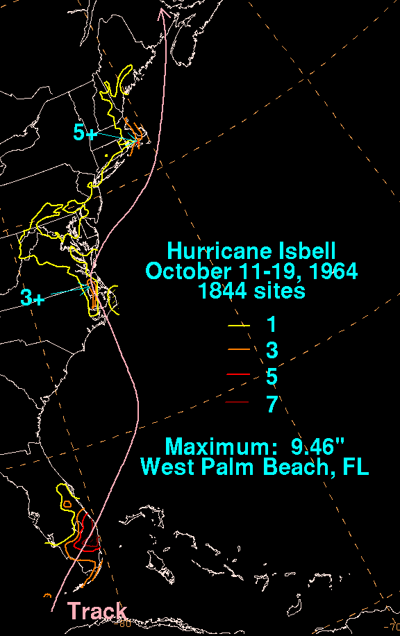 Isbell caused $20 million (1964 USD ($120 million 2005 USD)) in damage; most of it was from crop damage or tornadic
activity. The hurricane also caused 6 deaths.
); however, no information on wind speeds in far western Cuba was available due to the relatively small size of the storm and the sparse population of the region.
In the Guane
area, which was most strongly affected, heavy damage and three fatalities occurred. All of the fatalities were from housing collapses. Four total deaths were reported. Hundreds of homes were also destroyed, and crops were ruined. The local tobacco crop industry was heavily affected, and several tobacco warehouses were destroyed.
, a tornado demolished 12 house trailers, tore off the roof of a church during Mass
, and a house was blown across a road. No one in the congregation was injured.
1 person was reported dead, due to a heart attack while boarding up for the hurricane, 37 injured, and 12 hospitalized. 1 house was also reported destroyed, 33 with major damage and 631 with minor damage. 66 trailers were reported destroyed, and 88 were reported to have major damage. 90 mph (145 km/h) winds affected the state.
, 4.55 inches in Inman-Gramlang, 4.28 inches in Greer
, 3.90 inches in Kinstree, and 3.84 inches in Orangeburg
.
Gusts up to 65 mph (105 km/h) were reported in Elizabeth City, North Carolina
on October 16, but no significant wind damage was reported. Considerable weakening occurred before landfall, causing only fairly minor damage and some beach erosion. Direct damage was primarily to low-lying areas.
However, six or more tornadoes occurred after landfall. They demolished trailers, unroofed homes and other buildings in several North Carolina communities. President Lyndon B. Johnson
declared some counties in North Carolina as disaster areas. The most affected area was Boynton Beach where 20 house trailers were destroyed and 22 people were injured.
Crop damage was reported from the storm. Flash flood
ing and large damage to peanut
s occurred at landfall, due to wet soil. Isbell was not retired due to the lack of major damage. However, the name had not been used since then, as the tropical cyclone naming lists were changed in 1979.
1964 Atlantic hurricane season
The 1964 Atlantic hurricane season officially began on June 15, 1964, and lasted until November 15, 1964. These dates conventionally delimit the period of each year when most tropical cyclones form in the Atlantic basin...
. It became a tropical depression east of Nicaragua
Nicaragua
Nicaragua is the largest country in the Central American American isthmus, bordered by Honduras to the north and Costa Rica to the south. The country is situated between 11 and 14 degrees north of the Equator in the Northern Hemisphere, which places it entirely within the tropics. The Pacific Ocean...
on October 8. It then strengthened into a tropical storm and later into a hurricane on October 13 before making landfall in western Cuba
Cuba
The Republic of Cuba is an island nation in the Caribbean. The nation of Cuba consists of the main island of Cuba, the Isla de la Juventud, and several archipelagos. Havana is the largest city in Cuba and the country's capital. Santiago de Cuba is the second largest city...
. In the Gulf of Mexico, on October 14, it strengthened into a major hurricane before making landfall in southwest Florida
Florida
Florida is a state in the southeastern United States, located on the nation's Atlantic and Gulf coasts. It is bordered to the west by the Gulf of Mexico, to the north by Alabama and Georgia and to the east by the Atlantic Ocean. With a population of 18,801,310 as measured by the 2010 census, it...
as a Category 2 hurricane. After entering the Atlantic
Atlantic Ocean
The Atlantic Ocean is the second-largest of the world's oceanic divisions. With a total area of about , it covers approximately 20% of the Earth's surface and about 26% of its water surface area...
, it headed towards North Carolina and made landfall on October 16 just before weakening to an extratropical storm with winds under hurricane force at 45 mph (70 km/h). It then dissipated the following day. It caused $20 million (1964 USD) ($120 million in 2005 USD) in damage, most of it being from crop damage or tornadic
Tornado
A tornado is a violent, dangerous, rotating column of air that is in contact with both the surface of the earth and a cumulonimbus cloud or, in rare cases, the base of a cumulus cloud. They are often referred to as a twister or a cyclone, although the word cyclone is used in meteorology in a wider...
activity. In addition to damage, it caused 6 deaths.
Meteorological history
An old diffused frontal trough entered the western Caribbean SeaCaribbean Sea
The Caribbean Sea is a sea of the Atlantic Ocean located in the tropics of the Western hemisphere. It is bounded by Mexico and Central America to the west and southwest, to the north by the Greater Antilles, and to the east by the Lesser Antilles....
in early October. Evidence of a tropical disturbance originated over the western Caribbean during October 7 and October 8 at the very end of this frontal trough. The system developed and a weak tropical depression formed on October 8 as it started to move slowly to the northwest. On October 12, it stalled its northwestern progress and made a small loop, followed by a northeastward turn. Lack of inflow and possible earlier land interaction kept the depression fairly weak, but it was able to strengthen 5 mph (10 km/h) further from its original strength later that day, and then reached tropical storm strength on October 13 and was designated as Tropical Storm Isbell.
Isbell reached hurricane intensity around 18 UTC
Coordinated Universal Time
Coordinated Universal Time is the primary time standard by which the world regulates clocks and time. It is one of several closely related successors to Greenwich Mean Time. Computer servers, online services and other entities that rely on having a universally accepted time use UTC for that purpose...
on October 13 shortly after reaching tropical storm status earlier that day. A few hours after being upgraded, the storm made landfall in the extreme western portion of Cuba. It then crossed western Cuba
Cuba
The Republic of Cuba is an island nation in the Caribbean. The nation of Cuba consists of the main island of Cuba, the Isla de la Juventud, and several archipelagos. Havana is the largest city in Cuba and the country's capital. Santiago de Cuba is the second largest city...
, entered the southeast Gulf of Mexico, and began to strengthen into a Category 3
Saffir-Simpson Hurricane Scale
The Saffir–Simpson Hurricane Scale , or the Saffir–Simpson Hurricane Wind Scale , classifies hurricanes — Western Hemisphere tropical cyclones that exceed the intensities of tropical depressions and tropical storms — into five categories distinguished by the intensities of their sustained winds...
hurricane.
Isbell reached its peak strength, with winds of 125 mph (205 km/h), southwest of Key West
Key West, Florida
Key West is a city in Monroe County, Florida, United States. The city encompasses the island of Key West, the part of Stock Island north of U.S. 1 , Sigsbee Park , Fleming Key , and Sunset Key...
. Subsequently, Isbell weakened and made landfall in Florida near Everglades City as a Category 2 hurricane on October 14. Maintaining intensity across the southern Florida peninsula, Isbell maintained hurricane status as it reached the western Atlantic
Atlantic Ocean
The Atlantic Ocean is the second-largest of the world's oceanic divisions. With a total area of about , it covers approximately 20% of the Earth's surface and about 26% of its water surface area...
that night, but the storm began to steadily weaken while moving north. It maintained its hurricane force winds until October 16. Isbell became extratropical, with winds of 45 mph (70 km/h), shortly before its final landfall near Morehead City, North Carolina
Morehead City, North Carolina
Morehead City is a port city in Carteret County, North Carolina, United States. The population was 8,661 at the 2010 census. Morehead City celebrated the 150th anniversary of its founding on May 5, 2007...
on October 16, and dissipated the next day after moving inland.
Preparations
In Cuba thousands were evacuated due to flooding lowlands.Numerous hurricane warnings and watches were issued prior to landfall in Florida. Advisories were broadcast and issued warning of the possibility of heavy rains and winds, isolated small hail, and possible isolated tornadoes from 4 to 10 PM CST October 14, 1964. The aviation severe weather forecast also notified people that within an area south and east of a line from sixty miles southwest of Miami
Miami, Florida
Miami is a city located on the Atlantic coast in southeastern Florida and the county seat of Miami-Dade County, the most populous county in Florida and the eighth-most populous county in the United States with a population of 2,500,625...
north to Gainesville
Gainesville, Florida
Gainesville is the largest city in, and the county seat of, Alachua County, Florida, United States as well as the principal city of the Gainesville, Florida Metropolitan Statistical Area . The preliminary 2010 Census population count for Gainesville is 124,354. Gainesville is home to the sixth...
, as well as to 40 miles north of Daytona Beach
Daytona Beach, Florida
Daytona Beach is a city in Volusia County, Florida, USA. According to 2008 U.S. Census Bureau estimates, the city has a population of 64,211. Daytona Beach is a principal city of the Deltona – Daytona Beach – Ormond Beach, Florida Metropolitan Statistical Area, which the census bureau estimated had...
, 3/4 inch maximum hail, gusts of up to 85 km/h, and one to two tornadoes were possible on October 14. Flood warnings were also issued, with predictions of flooding 4 feet above flood stage. Emergency preparations at Key West
Key West
Key West is an island in the Straits of Florida on the North American continent at the southernmost tip of the Florida Keys. Key West is home to the southernmost point in the Continental United States; the island is about from Cuba....
's weather office were made. On October 13, 1964, in the morning hours the office alerted city, county, and military officials. In the afternoon, they completed office preparations and scheduling, they also checked equipment. Later, gale warning
Gale warning
A gale warning is a warning issued by weather services in maritime locations about the existence of winds of gale force or above or the imminent occurrence of gales at sea...
s and hurricane watches were issued for the lower Florida Keys
Florida Keys
The Florida Keys are a coral archipelago in southeast United States. They begin at the southeastern tip of the Florida peninsula, about south of Miami, and extend in a gentle arc south-southwest and then westward to Key West, the westernmost of the inhabited islands, and on to the uninhabited Dry...
. Hurricane warnings were issued for the Dry Tortugas
Dry Tortugas
The Dry Tortugas are a small group of islands, located at the end of the Florida Keys, USA, about west of Key West, and west of the Marquesas Keys, the closest islands. Still further west is the Tortugas Bank, which is completely submerged. The first Europeans to discover the islands were the...
. Even later the gale warnings and hurricane watches for the lower Florida Keys were upgraded to hurricane warnings. On the 14th, they requested radio stations to stay on the air, relayed hourly reports, and lowered the hurricane warnings for the lower keys.
Hurricane warnings were issued along the North Carolina coast south of Morehead City
Morehead City, North Carolina
Morehead City is a port city in Carteret County, North Carolina, United States. The population was 8,661 at the 2010 census. Morehead City celebrated the 150th anniversary of its founding on May 5, 2007...
. Hurricane watches were issued north of Morehead City
Morehead City, North Carolina
Morehead City is a port city in Carteret County, North Carolina, United States. The population was 8,661 at the 2010 census. Morehead City celebrated the 150th anniversary of its founding on May 5, 2007...
. Some tidal flooding was also forecast. People were warned to tune to television and radio broadcasts.
Impact
Tornado
A tornado is a violent, dangerous, rotating column of air that is in contact with both the surface of the earth and a cumulonimbus cloud or, in rare cases, the base of a cumulus cloud. They are often referred to as a twister or a cyclone, although the word cyclone is used in meteorology in a wider...
activity. The hurricane also caused 6 deaths.
Cuba
70 mph (110 km/h) gusts were reported as far east as Boyeros Airport in the capital of Havana, along with a lowest recorded pressure of 979 mbar (hPaPascal (unit)
The pascal is the SI derived unit of pressure, internal pressure, stress, Young's modulus and tensile strength, named after the French mathematician, physicist, inventor, writer, and philosopher Blaise Pascal. It is a measure of force per unit area, defined as one newton per square metre...
); however, no information on wind speeds in far western Cuba was available due to the relatively small size of the storm and the sparse population of the region.
In the Guane
Guane
Guane is a municipality and city in the Pinar del Río Province of Cuba.The municipality is divided into the barrios of Cabo de San Antonio y La Fe, Catalina, Cortés, Hato de Guane, Isabel Rubio , Juan Gómez, La Grifa, Las Martinas, Los Acostas, Manuel Lazo , Portales, Pueblo, Punta de la Sierra,...
area, which was most strongly affected, heavy damage and three fatalities occurred. All of the fatalities were from housing collapses. Four total deaths were reported. Hundreds of homes were also destroyed, and crops were ruined. The local tobacco crop industry was heavily affected, and several tobacco warehouses were destroyed.
Florida
Isbell produced numerous small and dangerous tornadoes as it passed Florida. An eyewitness account said that tornadoes from Isbell "caused as much damage as the hurricane did." Another eyewitness also noted that severe rains occurred during the early portions of the storm, but that eventually it died down to fairly light rain. In Eau GallieEau Gallie, Florida
Eau Gallie was a city in Brevard County, Florida from 1857 until 1969 when citizens voted to merge with neighboring Melbourne, Florida. It is now a small district in the north part of the city, near the Eau Gallie Causeway. William Henry Gleason founded the city. From 1874 to 1878 it served as the...
, a tornado demolished 12 house trailers, tore off the roof of a church during Mass
Mass
Mass can be defined as a quantitive measure of the resistance an object has to change in its velocity.In physics, mass commonly refers to any of the following three properties of matter, which have been shown experimentally to be equivalent:...
, and a house was blown across a road. No one in the congregation was injured.
1 person was reported dead, due to a heart attack while boarding up for the hurricane, 37 injured, and 12 hospitalized. 1 house was also reported destroyed, 33 with major damage and 631 with minor damage. 66 trailers were reported destroyed, and 88 were reported to have major damage. 90 mph (145 km/h) winds affected the state.
Carolinas and Mid-Atlantic States
Isbell had widespread rains throughout the Carolinas and Mid-Atlantic including these totals of 5.14 inches in ColumbiaColumbia, South Carolina
Columbia is the state capital and largest city in the U.S. state of South Carolina. The population was 129,272 according to the 2010 census. Columbia is the county seat of Richland County, but a portion of the city extends into neighboring Lexington County. The city is the center of a metropolitan...
, 4.55 inches in Inman-Gramlang, 4.28 inches in Greer
Greer, South Carolina
Greer is a city in Greenville and Spartanburg counties in the U.S. state of South Carolina, between the cities of Greenville and Spartanburg. The population was 25,515 at the 2010 census. It is projected to hit 30,000 within 4 years. Each day, more than three times that number of people pass...
, 3.90 inches in Kinstree, and 3.84 inches in Orangeburg
Orangeburg, South Carolina
Orangeburg, also known as "The Garden City," is the principal city in and the county seat of Orangeburg County, South Carolina, United States. The city is also the fifth oldest city in the state of South Carolina. The city population was 12,765 at the 2000 census, within a Greater Orangeburg...
.
Gusts up to 65 mph (105 km/h) were reported in Elizabeth City, North Carolina
Elizabeth City, North Carolina
Elizabeth City is a city in Pasquotank County and Camden County in the State of North Carolina. With a population of 18,683 at the 2010 census, Elizabeth City is the county seat of Pasquotank County....
on October 16, but no significant wind damage was reported. Considerable weakening occurred before landfall, causing only fairly minor damage and some beach erosion. Direct damage was primarily to low-lying areas.
However, six or more tornadoes occurred after landfall. They demolished trailers, unroofed homes and other buildings in several North Carolina communities. President Lyndon B. Johnson
Lyndon B. Johnson
Lyndon Baines Johnson , often referred to as LBJ, was the 36th President of the United States after his service as the 37th Vice President of the United States...
declared some counties in North Carolina as disaster areas. The most affected area was Boynton Beach where 20 house trailers were destroyed and 22 people were injured.
Crop damage was reported from the storm. Flash flood
Flash flood
A flash flood is a rapid flooding of geomorphic low-lying areas—washes, rivers, dry lakes and basins. It may be caused by heavy rain associated with a storm, hurricane, or tropical storm or meltwater from ice or snow flowing over ice sheets or snowfields...
ing and large damage to peanut
Peanut
The peanut, or groundnut , is a species in the legume or "bean" family , so it is not a nut. The peanut was probably first cultivated in the valleys of Peru. It is an annual herbaceous plant growing tall...
s occurred at landfall, due to wet soil. Isbell was not retired due to the lack of major damage. However, the name had not been used since then, as the tropical cyclone naming lists were changed in 1979.