
Hood Mountain
Encyclopedia
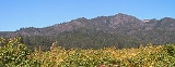
Mount Hood, also known as Hood Mountain is a mountain near the southeastern edge of Santa Rosa, California
at the northeast of the Sonoma Valley
and attains a height of 2733 feet (833 m). The originally name was Mount Wilikos, an Indian name meaning "willows."
Most of the drainage from Mount Hood contributes to the headwaters of Sonoma Creek
. A prominent feature is the extensive rock face visible on the upper half of the mountain as viewed from State Route 12. The habitat
s on the mountain include mixed oak forest, pygmy forest
, chaparral
and riparian zone
s. In prehistoric times the slopes of Mount Hood were inhabited by a division of the Yuki tribe
. Most of Mount Hood is within the Hood Mountain Regional Park maintained by Sonoma County. Mount Hood is part of the inner coast Mayacamas Range, and lies mostly within Sonoma County, with a part of the mountain geographically within Napa County. Mount Hood affords overlooks of the Pacific Ocean
, San Francisco Bay
and "a spectacular view east to the Sierra Nevada Range."
 Mount Hood is most easily accessed via State Route 12, which runs along the bottomland of the Sonoma Valley and connects the town of Sonoma
to the city of Santa Rosa
. Closest viewing areas of Mount Hood from the valley floor are from the village of Kenwood
, from the intersection of State Route 12 with Pythian Road, and from the community of Oakmont, the easternmost neighborhood of Santa Rosa. From these viewing locations a volcanic rocky outcrop near the peak of Mount Hood, also known as Gunsight Point, is prominent on the Mayacmas ridgeline, along with Bald Mountain, within Sugarloaf Ridge State Park
, itself located approximately three miles east.
Mount Hood is also visible from the floor of the Napa Valley as well as eastern slopes above that valley. From the summit there are expansive views westerly to Annadel State Park
and beyond to Sonoma Mountain
. On clear days there are distant views westerly to the Pacific Ocean and easterly to the Sierra Nevada Mountains.
 The base of Mount Hood consists of soils of the Goulding-Toomes-Guenoc association, which are well-drained gently to very steep loam
s and clay
-loams situated upon upland formations. The upper reaches consist of the Kidd-Forward-Cohasset association, which group ranges from well-drained to excessively drained moderate to very steep gravel
ly and stony loams. Specific soil map patches on the upper slopes include Boomer loam on some 15 to 30 percent slopes; Goulding cobbly clay loam on 15 to 30 percent slopes; Henneke gravelly loam on some 5 to 30 percent slopes; Henneke gravelly loam on 30 to 75 percent slopes; and rock land on 15 to 75 percent slopes.
Considering the steepness of much of the terrain there is a remarkable lack of erosion, primarily because human access has been historically low, and vegetative cover has been kept intact. The headwaters of Santa Rosa Creek
rise on the northern slopes of Mount Hood, whereas the central and eastern portions of the mountain contribute to the watershed of Sonoma Creek
which rises in the Sugarloaf area. Hood Creek and Graywood Creek, draining portions of Mount Hood, are smaller tributaries that feed Sonoma Creek. Precipitation amounts to approximately 30 inches (76.2 cm) per annum on Mount Hood.
s in the Mount Hood area including:
In addition there are is a specialized habitat on the upper western face consisting of extensive rock outcrop
s, which can be considered a variant of the chaparral habitat with small forest
pockets.
 The mixed oak woodland habitat dominates the lower elevations with Coast live oak
, Douglas fir, California Buckeye
and Bigleaf Maple
forming the majority of the canopy. The understory is sparse, particularly of the deep ravine areas such as Hood Creek riparian zones. Some Toyon
, Poison oak
and Hollyleaf cherry
are found beneath the canopy. At mid-level elevations there are also considerable numbers of Tanbark oak and Pacific Madrone
contributing to the canopy.
Chaparral areas are dominated by several varieties of manzanita
, including notably Arctostaphylos
manzanita 'Mount Hood'. There is also a considerable abundance of poison oak and coyote brush present in these exposed rocky thin soil habitats. Fire risk is naturally greatest in this ecosystem, and some evidence of fires are seen at an estimated age of twenty years past.
There are sizable pygmy forest areas on the west facing slopes and more level inner plateaus of Mount Hood. Here the predominant species are Sargent Cypress
, various Arctostaphylos species and coyote brush. The Sargent Cypress were formerly misidentified as Mendocino Cypress (Cupressus pygmaea), which would be far out of their native range here. The height of the pygmy forest is ten to fifteen feet (3 – 5 m) and these patches of relatively dense thickets extend for about a half to one and a half miles (one to two kilometers) in patch size.
The riparian zones tend to occur in deep heavily forested ravine
areas that are highly shaded. These typically steep woodlands have a high percentage of California laurel trees, understory fern
s and toyons. Several of the streams such as Sonoma Creek, Hood Creek and Santa Rosa Creek
are generally year-round flowing, except for the very highest reaches (e.g. above 2,200 feet (671 m)). Considerable bird life occurs in the Mount Hood environment, but particularly in the riparian zones Scrub Jay, woodpecker
s and junco
s are apparent.
Mountain lions, bobcat
s and rattlesnake
s may be found throughout the area, with the snakes preferring west facing sun-exposed rocky slopes.
Trails leading from the first two trailheads involve relatively direct climbs of about 2,000 vertical feet (610 m) to the summit
, whereas trails from the Los Alamos Road trailhead take a longer route to the summit but involve about the same vertical rise.
The Goodspeed/Nattkemper Trail, which climbs to the summit from the Adobe Canyon Road trailhead, offers the most direct access to the summit and to Gunsight Rock, from which distant views to the south and west are available. From the Los Alamos Road trailhead, the Hood Mountain Trail descends to and crosses Santa Rosa Creek
, then climbs via an easily walked fireroad to the summit, passing through the pygmy forest
on the northwest side of the mountain. The Summit Trail branches from the Hood Mountain Trail at about 1,400 feet (427 m) elevation and offers a more rugged hike to the summit. From the Pythian Road trailhead, the Lower and Upper Johnson Ridge trails climb relatively directly to the Hood Mountain Trail and on to the summit. The Pythian Road trailhead also provides good access to the pygmy forest
via the Panorama Ranch Trail.
There is no potable water supplied within the Mount Hood area except at the parking lot at the Pythian Road trailhead. Overnight camping
is not permitted, but dogs on leash
es are allowed.
Santa Rosa, California
Santa Rosa is the county seat of Sonoma County, California, United States. The 2010 census reported a population of 167,815. Santa Rosa is the largest city in California's Wine Country and fifth largest city in the San Francisco Bay Area, after San Jose, San Francisco, Oakland, and Fremont and 26th...
at the northeast of the Sonoma Valley
Sonoma Valley
Sonoma Valley is the birthplace of the California wine industry and often called The Valley of the Moon. Sonoma Valley is home to some of the earliest vineyards and wineries in the state, some of which survived the phylloxera epidemic of the 1870s and the impact of Prohibition...
and attains a height of 2733 feet (833 m). The originally name was Mount Wilikos, an Indian name meaning "willows."
Most of the drainage from Mount Hood contributes to the headwaters of Sonoma Creek
Sonoma Creek
Sonoma Creek is a stream in northern California. It is one of two principal drainages of southern Sonoma County, California, with headwaters rising in the rugged hills of Sugarloaf Ridge State Park and discharging to San Pablo Bay, the northern arm of San Francisco Bay. The watershed drained by...
. A prominent feature is the extensive rock face visible on the upper half of the mountain as viewed from State Route 12. The habitat
Habitat
* Habitat , a place where a species lives and grows*Human habitat, a place where humans live, work or play** Space habitat, a space station intended as a permanent settlement...
s on the mountain include mixed oak forest, pygmy forest
Pygmy forest
A pygmy forest is a forest which, for pedological and geological reasons, contains only miniature trees. Pygmy forests may occur over various world locations with notable occurrences being noted in the literature of the: California coastal terraces and inner coastal mountains of Northern...
, chaparral
Chaparral
Chaparral is a shrubland or heathland plant community found primarily in the U.S. state of California and in the northern portion of the Baja California peninsula, Mexico...
and riparian zone
Riparian zone
A riparian zone or riparian area is the interface between land and a river or stream. Riparian is also the proper nomenclature for one of the fifteen terrestrial biomes of the earth. Plant habitats and communities along the river margins and banks are called riparian vegetation, characterized by...
s. In prehistoric times the slopes of Mount Hood were inhabited by a division of the Yuki tribe
Yuki tribe
The Yuki are a Native American people from the zone of Round Valley, in what today is part of the territory of Mendocino County, Northern California. Yuki tribes are thought to have settled as far south as Hood Mountain in present-day Sonoma County...
. Most of Mount Hood is within the Hood Mountain Regional Park maintained by Sonoma County. Mount Hood is part of the inner coast Mayacamas Range, and lies mostly within Sonoma County, with a part of the mountain geographically within Napa County. Mount Hood affords overlooks of the Pacific Ocean
Pacific Ocean
The Pacific Ocean is the largest of the Earth's oceanic divisions. It extends from the Arctic in the north to the Southern Ocean in the south, bounded by Asia and Australia in the west, and the Americas in the east.At 165.2 million square kilometres in area, this largest division of the World...
, San Francisco Bay
San Francisco Bay
San Francisco Bay is a shallow, productive estuary through which water draining from approximately forty percent of California, flowing in the Sacramento and San Joaquin rivers from the Sierra Nevada mountains, enters the Pacific Ocean...
and "a spectacular view east to the Sierra Nevada Range."
Area setting
Sonoma, California
Sonoma is a historically significant city in Sonoma Valley, Sonoma County, California, USA, surrounding its historic town plaza, a remnant of the town's Mexican colonial past. It was the capital of the short-lived California Republic...
to the city of Santa Rosa
Santa Rosa, California
Santa Rosa is the county seat of Sonoma County, California, United States. The 2010 census reported a population of 167,815. Santa Rosa is the largest city in California's Wine Country and fifth largest city in the San Francisco Bay Area, after San Jose, San Francisco, Oakland, and Fremont and 26th...
. Closest viewing areas of Mount Hood from the valley floor are from the village of Kenwood
Kenwood, California
Kenwood, California is an unincorporated town and census-designated place in Sonoma County, California, United States, located on Sonoma Highway between the cities Santa Rosa and Sonoma. It lies east of Sonoma Creek in the upper part of Sonoma Valley, a region sometimes called the Valley of the...
, from the intersection of State Route 12 with Pythian Road, and from the community of Oakmont, the easternmost neighborhood of Santa Rosa. From these viewing locations a volcanic rocky outcrop near the peak of Mount Hood, also known as Gunsight Point, is prominent on the Mayacmas ridgeline, along with Bald Mountain, within Sugarloaf Ridge State Park
Sugarloaf Ridge State Park
Sugarloaf Ridge State Park is a state park in Northern California, U.S.A.. Located in the Mayacamas Mountains north of Kenwood, the park straddles the boundary between Sonoma and Napa counties...
, itself located approximately three miles east.
Mount Hood is also visible from the floor of the Napa Valley as well as eastern slopes above that valley. From the summit there are expansive views westerly to Annadel State Park
Annadel State Park
Annadel State Park is a state park of California, USA, situated at the northern edge of Sonoma Valley and offering many recreational activities within its property...
and beyond to Sonoma Mountain
Sonoma Mountain
Sonoma Mountain is a prominent landform within the Sonoma Mountains of southern Sonoma County, California. At elevation of , Sonoma Mountain offers expansive views of the Pacific Ocean to the west and the Sonoma Valley to the east...
. On clear days there are distant views westerly to the Pacific Ocean and easterly to the Sierra Nevada Mountains.
Geology and hydrology
Loam
Loam is soil composed of sand, silt, and clay in relatively even concentration . Loam soils generally contain more nutrients and humus than sandy soils, have better infiltration and drainage than silty soils, and are easier to till than clay soils...
s and clay
Clay
Clay is a general term including many combinations of one or more clay minerals with traces of metal oxides and organic matter. Geologic clay deposits are mostly composed of phyllosilicate minerals containing variable amounts of water trapped in the mineral structure.- Formation :Clay minerals...
-loams situated upon upland formations. The upper reaches consist of the Kidd-Forward-Cohasset association, which group ranges from well-drained to excessively drained moderate to very steep gravel
Gravel
Gravel is composed of unconsolidated rock fragments that have a general particle size range and include size classes from granule- to boulder-sized fragments. Gravel can be sub-categorized into granule and cobble...
ly and stony loams. Specific soil map patches on the upper slopes include Boomer loam on some 15 to 30 percent slopes; Goulding cobbly clay loam on 15 to 30 percent slopes; Henneke gravelly loam on some 5 to 30 percent slopes; Henneke gravelly loam on 30 to 75 percent slopes; and rock land on 15 to 75 percent slopes.
Considering the steepness of much of the terrain there is a remarkable lack of erosion, primarily because human access has been historically low, and vegetative cover has been kept intact. The headwaters of Santa Rosa Creek
Santa Rosa Creek
Santa Rosa Creek is a 22 mile long stream in Sonoma County, California which rises on Hood Mountain and discharges to the Laguna de Santa Rosa by way of the Santa Rosa Flood Control Channel...
rise on the northern slopes of Mount Hood, whereas the central and eastern portions of the mountain contribute to the watershed of Sonoma Creek
Sonoma Creek
Sonoma Creek is a stream in northern California. It is one of two principal drainages of southern Sonoma County, California, with headwaters rising in the rugged hills of Sugarloaf Ridge State Park and discharging to San Pablo Bay, the northern arm of San Francisco Bay. The watershed drained by...
which rises in the Sugarloaf area. Hood Creek and Graywood Creek, draining portions of Mount Hood, are smaller tributaries that feed Sonoma Creek. Precipitation amounts to approximately 30 inches (76.2 cm) per annum on Mount Hood.
Ecology
There are several distinct habitatHabitat
* Habitat , a place where a species lives and grows*Human habitat, a place where humans live, work or play** Space habitat, a space station intended as a permanent settlement...
s in the Mount Hood area including:
- Mixed oakOakAn oak is a tree or shrub in the genus Quercus , of which about 600 species exist. "Oak" may also appear in the names of species in related genera, notably Lithocarpus...
woodlandWoodlandEcologically, a woodland is a low-density forest forming open habitats with plenty of sunlight and limited shade. Woodlands may support an understory of shrubs and herbaceous plants including grasses. Woodland may form a transition to shrubland under drier conditions or during early stages of... - ChaparralChaparralChaparral is a shrubland or heathland plant community found primarily in the U.S. state of California and in the northern portion of the Baja California peninsula, Mexico...
- Pygmy forestPygmy forestA pygmy forest is a forest which, for pedological and geological reasons, contains only miniature trees. Pygmy forests may occur over various world locations with notable occurrences being noted in the literature of the: California coastal terraces and inner coastal mountains of Northern...
- Riparian zoneRiparian zoneA riparian zone or riparian area is the interface between land and a river or stream. Riparian is also the proper nomenclature for one of the fifteen terrestrial biomes of the earth. Plant habitats and communities along the river margins and banks are called riparian vegetation, characterized by...
In addition there are is a specialized habitat on the upper western face consisting of extensive rock outcrop
Outcrop
An outcrop is a visible exposure of bedrock or ancient superficial deposits on the surface of the Earth. -Features:Outcrops do not cover the majority of the Earth's land surface because in most places the bedrock or superficial deposits are covered by a mantle of soil and vegetation and cannot be...
s, which can be considered a variant of the chaparral habitat with small forest
Forest
A forest, also referred to as a wood or the woods, is an area with a high density of trees. As with cities, depending where you are in the world, what is considered a forest may vary significantly in size and have various classification according to how and what of the forest is composed...
pockets.
Coast Live Oak
Quercus agrifolia, the Coast Live Oak, is an evergreen oak , native to the California Floristic Province. It grows west of the Sierra Nevada from Mendocino County, California, south to northern Baja California in Mexico. It is classified in the red oak section Quercus agrifolia, the Coast Live Oak,...
, Douglas fir, California Buckeye
Aesculus californica
Aesculus californica is a species of buckeye that is native [ |] to California and southwest Oregon [Jackson, County], and the only buckeye native to these states.-Description:...
and Bigleaf Maple
Bigleaf Maple
Acer macrophyllum is a large deciduous tree in the genus Acer.It can grow to be up to 35 m tall, but more commonly grows 15 m to 20 m tall. It is native to western North America, mostly near the Pacific coast, from southernmost Alaska to southern California...
forming the majority of the canopy. The understory is sparse, particularly of the deep ravine areas such as Hood Creek riparian zones. Some Toyon
Toyon
Heteromeles arbutifolia , and commonly known as Toyon, is a common perennial shrub native to California down to Baja California....
, Poison oak
Poison oak
Poison oak may refer to* Toxicodendron diversilobum, grows on West Coast of North America* Toxicodendron pubescens, grows in the Eastern United Statesdamnnnnn tissss is terribleee...
and Hollyleaf cherry
Prunus ilicifolia
Prunus ilicifolia is an evergreen shrub to tree, producing edible cherries, with shiny and spiny toothed leaves similar in appearance to holly...
are found beneath the canopy. At mid-level elevations there are also considerable numbers of Tanbark oak and Pacific Madrone
Pacific Madrone
Arbutus menziesii, commonly known as the Pacific Madrone, is a species of Arbutus found on the west coast of North America, from British Columbia to California...
contributing to the canopy.
Chaparral areas are dominated by several varieties of manzanita
Manzanita
Manzanita is a common name for many species of the genus Arctostaphylos. They are evergreen shrubs or small trees present in the chaparral biome of western North America, where they occur from southern British Columbia, Washington to California, Arizona and New Mexico in the United States, and...
, including notably Arctostaphylos
Arctostaphylos
Arctostaphylos is a genus of plants comprised by the manzanitas and bearberries. They are shrubs or small trees.There are about 60 species of Arctostaphylos, ranging from ground-hugging arctic, coastal, and mountain species to small trees up to 6 m tall. Most are evergreen , with small oval...
manzanita 'Mount Hood'. There is also a considerable abundance of poison oak and coyote brush present in these exposed rocky thin soil habitats. Fire risk is naturally greatest in this ecosystem, and some evidence of fires are seen at an estimated age of twenty years past.
There are sizable pygmy forest areas on the west facing slopes and more level inner plateaus of Mount Hood. Here the predominant species are Sargent Cypress
Cupressus sargentii
Cupressus sargentii is a species of conifer in the Cupressaceae family known by the common name Sargent's cypress. It is endemic to California, where it is known from Mendocino county southwards to Santa Barbara county. This taxon is limited to the Coast Range mountains. Like Mcnab Cypress, it...
, various Arctostaphylos species and coyote brush. The Sargent Cypress were formerly misidentified as Mendocino Cypress (Cupressus pygmaea), which would be far out of their native range here. The height of the pygmy forest is ten to fifteen feet (3 – 5 m) and these patches of relatively dense thickets extend for about a half to one and a half miles (one to two kilometers) in patch size.
The riparian zones tend to occur in deep heavily forested ravine
Ravine
A ravine is a landform narrower than a canyon and is often the product of streamcutting erosion. Ravines are typically classified as larger in scale than gullies, although smaller than valleys. A ravine is generally a fluvial slope landform of relatively steep sides, on the order of twenty to...
areas that are highly shaded. These typically steep woodlands have a high percentage of California laurel trees, understory fern
Fern
A fern is any one of a group of about 12,000 species of plants belonging to the botanical group known as Pteridophyta. Unlike mosses, they have xylem and phloem . They have stems, leaves, and roots like other vascular plants...
s and toyons. Several of the streams such as Sonoma Creek, Hood Creek and Santa Rosa Creek
Santa Rosa Creek
Santa Rosa Creek is a 22 mile long stream in Sonoma County, California which rises on Hood Mountain and discharges to the Laguna de Santa Rosa by way of the Santa Rosa Flood Control Channel...
are generally year-round flowing, except for the very highest reaches (e.g. above 2,200 feet (671 m)). Considerable bird life occurs in the Mount Hood environment, but particularly in the riparian zones Scrub Jay, woodpecker
Woodpecker
Woodpeckers are near passerine birds of the order Piciformes. They are one subfamily in the family Picidae, which also includes the piculets and wrynecks. They are found worldwide and include about 180 species....
s and junco
Junco
A Junco , genus Junco, is a small North American bird. Junco systematics are still confusing after decades of research, with various authors accepting between three and twelve species...
s are apparent.
Mountain lions, bobcat
Bobcat
The bobcat is a North American mammal of the cat family Felidae, appearing during the Irvingtonian stage of around 1.8 million years ago . With twelve recognized subspecies, it ranges from southern Canada to northern Mexico, including most of the continental United States...
s and rattlesnake
Rattlesnake
Rattlesnakes are a group of venomous snakes of the genera Crotalus and Sistrurus of the subfamily Crotalinae . There are 32 known species of rattlesnake, with between 65-70 subspecies, all native to the Americas, ranging from southern Alberta and southern British Columbia in Canada to Central...
s may be found throughout the area, with the snakes preferring west facing sun-exposed rocky slopes.
Hiking
Trails leading to the summit of Mount Hood begin at three locations:- Along Adobe Canyon Road within Sugarloaf Ridge State ParkSugarloaf Ridge State ParkSugarloaf Ridge State Park is a state park in Northern California, U.S.A.. Located in the Mayacamas Mountains north of Kenwood, the park straddles the boundary between Sonoma and Napa counties...
, on the southeast side of the mountain - At the end of Pythian Road, on the west side
- At the end of Los Alamos Road, on the north side
Trails leading from the first two trailheads involve relatively direct climbs of about 2,000 vertical feet (610 m) to the summit
Summit (topography)
In topography, a summit is a point on a surface that is higher in elevation than all points immediately adjacent to it. Mathematically, a summit is a local maximum in elevation...
, whereas trails from the Los Alamos Road trailhead take a longer route to the summit but involve about the same vertical rise.
The Goodspeed/Nattkemper Trail, which climbs to the summit from the Adobe Canyon Road trailhead, offers the most direct access to the summit and to Gunsight Rock, from which distant views to the south and west are available. From the Los Alamos Road trailhead, the Hood Mountain Trail descends to and crosses Santa Rosa Creek
Santa Rosa Creek
Santa Rosa Creek is a 22 mile long stream in Sonoma County, California which rises on Hood Mountain and discharges to the Laguna de Santa Rosa by way of the Santa Rosa Flood Control Channel...
, then climbs via an easily walked fireroad to the summit, passing through the pygmy forest
Pygmy forest
A pygmy forest is a forest which, for pedological and geological reasons, contains only miniature trees. Pygmy forests may occur over various world locations with notable occurrences being noted in the literature of the: California coastal terraces and inner coastal mountains of Northern...
on the northwest side of the mountain. The Summit Trail branches from the Hood Mountain Trail at about 1,400 feet (427 m) elevation and offers a more rugged hike to the summit. From the Pythian Road trailhead, the Lower and Upper Johnson Ridge trails climb relatively directly to the Hood Mountain Trail and on to the summit. The Pythian Road trailhead also provides good access to the pygmy forest
Pygmy forest
A pygmy forest is a forest which, for pedological and geological reasons, contains only miniature trees. Pygmy forests may occur over various world locations with notable occurrences being noted in the literature of the: California coastal terraces and inner coastal mountains of Northern...
via the Panorama Ranch Trail.
There is no potable water supplied within the Mount Hood area except at the parking lot at the Pythian Road trailhead. Overnight camping
Camping
Camping is an outdoor recreational activity. The participants leave urban areas, their home region, or civilization and enjoy nature while spending one or several nights outdoors, usually at a campsite. Camping may involve the use of a tent, caravan, motorhome, cabin, a primitive structure, or no...
is not permitted, but dogs on leash
Leash
A leash is a rope or similar material attached to the neck or head of an animal for restraint or control...
es are allowed.
See also
- List of Sonoma County Regional Parks facilities
- List of summits in the San Francisco Bay Area
- William Hood HouseWilliam Hood HouseThe William Hood House was built in 1858 by William Hood. Its California Historical Landmark number is 692. It was listed on the National Register of Historic Places on February 6, 1998.The house was built from bricks that were made on the property...