
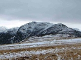
High Spy
Encyclopedia
England
England is a country that is part of the United Kingdom. It shares land borders with Scotland to the north and Wales to the west; the Irish Sea is to the north west, the Celtic Sea to the south west, with the North Sea to the east and the English Channel to the south separating it from continental...
Lake District
Lake District
The Lake District, also commonly known as The Lakes or Lakeland, is a mountainous region in North West England. A popular holiday destination, it is famous not only for its lakes and its mountains but also for its associations with the early 19th century poetry and writings of William Wordsworth...
it is situated on the ridge that separates the Newlands Valley
Newlands Valley
The Newlands Valley is in the Lake District National Park in Cumbria, England. It is regarded as one of the most picturesque and quiet valleys in the national park, even though it is situated very close to the popular tourist town of Keswick and the busy A66 road.The valley forms part of the civil...
from Borrowdale
Borrowdale
Borrowdale is a valley and civil parish in the English Lake District in the Borough of Allerdale in Cumbria, England.Borrowdale lies within the historic county boundaries of Cumberland, and is sometimes referred to as Cumberland Borrowdale in order to distinguish it from another Borrowdale in the...
, eight kilometres south of Keswick
Keswick, Cumbria
Keswick is a market town and civil parish within the Borough of Allerdale in Cumbria, England. It had a population of 4,984, according to the 2001 census, and is situated just north of Derwent Water, and a short distance from Bassenthwaite Lake, both in the Lake District National Park...
.
Topography
The fell reaches a height of 653 metres (2142 feet) and is defended by crags to the east and west as it falls away steeply to the valleys. It is a distinctive fell that has 148 metres of topographic prominenceTopographic prominence
In topography, prominence, also known as autonomous height, relative height, shoulder drop , or prime factor , categorizes the height of the mountain's or hill's summit by the elevation between it and the lowest contour line encircling it and no higher summit...
from the higher adjoining fell of Dale Head
Dale Head
Dale Head is a fell in the northwestern sector of the Lake District, in northern England. It is 753 metres or 2,470 feet above sea level and stands immediately north of Honister Pass, the road between Borrowdale and Buttermere.-Topography:...
and so misses being a Marilyn
Marilyn (hill)
A Marilyn is a mountain or hill in the United Kingdom, Republic of Ireland or Isle of Man with a relative height of at least 150 metres , regardless of absolute height or other merit...
by only two metres. Geologically the fell is made up of Borrowdale Volcanics
Borrowdale Volcanics
The Borrowdale Volcanic Group is a group of igneous rock formations named after the Borrowdale area of the Lake District, in England. They are late Ordovician in age . It is thought that they represent the remains of a volcanic island arc, approximately similar to the island arcs of the west...
. The meaning of the fell's name is obscure but may mean a “look out post” referring to some lost fort in the area. In the past it has been known as Scawdel Fell and Lobstone Band and these names are still used on maps to label other parts of the fell.

Cairn
Cairn is a term used mainly in the English-speaking world for a man-made pile of stones. It comes from the or . Cairns are found all over the world in uplands, on moorland, on mountaintops, near waterways and on sea cliffs, and also in barren desert and tundra areas...
which has been known to be vandalised
Vandalism
Vandalism is the behaviour attributed originally to the Vandals, by the Romans, in respect of culture: ruthless destruction or spoiling of anything beautiful or venerable...
on occasions but always seems to gets rebuilt by other walkers. The top of the fell is relatively flat for a distance of about 2.5 kilometres in a north to south direction and the impressive Eel Crags fall away vertically on the Newlands side of the fell, these crags are popular with rock climbers
Climbing
Climbing is the activity of using one's hands and feet to ascend a steep object. It is done both for recreation and professionally, as part of activities such as maintenance of a structure, or military operations.Climbing activities include:* Bouldering: Ascending boulders or small...
with the quality of the rock being very good. High Spy North Top stands almost a kilometre north of the main top it has a height of 634 metres (2080 feet) and is also classed as a Nuttall, it gives a fine view of Derwent Water
Derwent Water
Derwentwater is one of the principal bodies of water in the Lake District National Park in north west England. It lies wholly within the Borough of Allerdale, in the county of Cumbria....
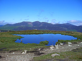
. 600 metres north of the main summit is a small unnamed tarn.
Ascents
High Spy is often climbed as part of the Newlands Horseshoe ridge walk but can be ascended directly despite being defended by crags on both its Newlands and Borrowdale sides. From Borrowdale a path goes from Rosthwaite and climbs through the disused Rigg Head Quarries to reach the colMountain pass
A mountain pass is a route through a mountain range or over a ridge. If following the lowest possible route, a pass is locally the highest point on that route...
linking High Spy to Dale Head and then up the south ridge to the summit passing a small unnamed tarn
Tarn (lake)
A tarn is a mountain lake or pool, formed in a cirque excavated by a glacier. A moraine may form a natural dam below a tarn. A corrie may be called a cirque.The word is derived from the Old Norse word tjörn meaning pond...
just before the top. From this side it is also possible to start from Grange and use an old drove road to get through the barrier of Blea Crag and then approach the summit. A scrambling
Scrambling
Scrambling is a method of ascending rocky faces and ridges. It is an ambiguous term that lies somewhere between hillwalking and rock climbing. It is often distinguished from hillwalking by defining a scramble as a route where hands must be used in the ascent...
route also starts from Grange, going via Hollows Farm it tackles the rocky rake of Nitting Haws directly. From Little Town in the Newlands valley an old mine road zig zags up to the col between the fell and Dale Head to then reach the top by the south ridge.
Mining
The latter route passes the Castlenook leadLead
Lead is a main-group element in the carbon group with the symbol Pb and atomic number 82. Lead is a soft, malleable poor metal. It is also counted as one of the heavy metals. Metallic lead has a bluish-white color after being freshly cut, but it soon tarnishes to a dull grayish color when exposed...
mine at the foot of the fell on the Newlands side, this mine, formerly owned by the Company of Mines Royal, started production in the 1860s and continued until 1918 when cheaper imports led to its closure. There are also signs of trial levels higher up the steep slope.