
High Halstow
Encyclopedia
High Halstow is a village and civil parish on the Hoo Peninsula
in the borough of Medway
in northern Kent
, England
. The parish had a population of 1,781 according to the 2001 census.
Originally known as Hagelstowe, Hagelsto or Agelstow, it was named from an Old English
word denoting a high, holy place. The area has been occupied by Romans, Saxons and Normans.
The village lies on the junction of the ancient roads from Hoo and Cliffe to the Isle of Grain
, now a crossroads to the north of the A228 road. One of the highest points on the Hoo peninsula, at 30 to 50 metres above sea level, the modern village consolidates into a single community the four hamlets of Clinch Street, Fenn Street, Sharnal Street and High Halstow Street.
of 1086, and was built on the highest point of the Hoo Peninsula, overlooking the rivers of the Thames and Medway
.
In the 18th century poverty and malnutrition were widespread across the peninsula, with High Halstow no exception; adult life expectancy was then about 30 years, lessened by ague, or marsh fever, the names for malaria
, which proliferated in the North Kent Marshes
and waterlogged farmland, a stronghold of the mosquito
. The cause of malaria was discovered in 1890, and within five years the number of people falling ill with the disease decreased sharply as farmland and marshes were drained. This task was performed in no small way by Henry Pye, after he moved to the area.
The village remained small until after the Second World War, comprising the church, a school, two shops, a pub, a wheelwright's shop, and an undertaker's, with the village being served by a single policeman. Eventually some of the older houses were demolished and replaced. Churchill Place was developed and in the area behind the church, formerly known as the Square, several modern bungalows replaced five thatched cottages. From 1952 more homes were built in the village to house Isle of Grain
oil refinery employees.
Historically, the main economic activity around High Halstow has been farming, but some of the village's residents gained employment outside the village, at the Royal Naval Armaments Depot
at Lodge Hill, Chattenden, and the Medway Oil and Storage Co at Grain. Chatham Dockyard
and the Short Brothers
seaplane works at Rochester were also traditional employers for the whole area until they shut many years ago.
In 1956 a new school opened, the old school building being demolished along with Hill Farm to make way for additional housing. Building development has continued intermittently, including the new estates of Northwood Park and Heron Fields, development of which began in 1998.
 The village still has its church, a shop and pub (the Red Dog) but has changed beyond recognition in living memory.
The village's cricket club has played in the area for almost 120 years. Ever expanding, the club now has four Saturday sides, one Sunday side and three colts sides. They play their home matches at Rayner's Meadow, which is situated in Christmas Lane, and at the Hundred of Hoo school, Hoo.
. It comprises 270 hectares (667 acres) of grazing marsh, woodland and farmland. Here is the largest heronry in Britain, where some 150-200 pairs nest. A heronry has been in the woods from at least 1947, when it was mentioned in a book on the Hundred of Hoo by Ralph Arnold. Many other birds, such as little egrets, avocets and marsh harriers, can also be seen in the reserve. This site was scheduled for demolition under government proposals for an international London airport in connection with the Thames Gateway
.
Northwood Hill, or Northward, was known once locally as "the Norrards". Beyond it on the marsh is a disused experimental radar
station, now part of the reserve.
Hoo Peninsula
The Hoo Peninsula is a peninsula in England separating the estuaries of the rivers Thames and Medway. It is dominated by a line of sand and clay hills, surrounded by an extensive area of marshland composed of alluvial silt. The name Hoo is the Old English word for spur of land.-History:The Romans...
in the borough of Medway
Medway
Medway is a conurbation and unitary authority in South East England. The Unitary Authority was formed in 1998 when the City of Rochester-upon-Medway amalgamated with Gillingham Borough Council and part of Kent County Council to form Medway Council, a unitary authority independent of Kent County...
in northern Kent
Kent
Kent is a county in southeast England, and is one of the home counties. It borders East Sussex, Surrey and Greater London and has a defined boundary with Essex in the middle of the Thames Estuary. The ceremonial county boundaries of Kent include the shire county of Kent and the unitary borough of...
, England
England
England is a country that is part of the United Kingdom. It shares land borders with Scotland to the north and Wales to the west; the Irish Sea is to the north west, the Celtic Sea to the south west, with the North Sea to the east and the English Channel to the south separating it from continental...
. The parish had a population of 1,781 according to the 2001 census.
Originally known as Hagelstowe, Hagelsto or Agelstow, it was named from an Old English
Old English language
Old English or Anglo-Saxon is an early form of the English language that was spoken and written by the Anglo-Saxons and their descendants in parts of what are now England and southeastern Scotland between at least the mid-5th century and the mid-12th century...
word denoting a high, holy place. The area has been occupied by Romans, Saxons and Normans.
The village lies on the junction of the ancient roads from Hoo and Cliffe to the Isle of Grain
Isle of Grain
The Isle of Grain, in the north of Kent, England, is the easternmost point of the Hoo Peninsula. No longer an island, the Isle is almost all marshland and the Grain Marshes are an important habitat for birdlife...
, now a crossroads to the north of the A228 road. One of the highest points on the Hoo peninsula, at 30 to 50 metres above sea level, the modern village consolidates into a single community the four hamlets of Clinch Street, Fenn Street, Sharnal Street and High Halstow Street.
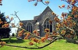
History
The 10th-century church of St Margaret at High Halstow was mentioned in the Domesday BookDomesday Book
Domesday Book , now held at The National Archives, Kew, Richmond upon Thames in South West London, is the record of the great survey of much of England and parts of Wales completed in 1086...
of 1086, and was built on the highest point of the Hoo Peninsula, overlooking the rivers of the Thames and Medway
River Medway
The River Medway, which is almost entirely in Kent, England, flows for from just inside the West Sussex border to the point where it enters the Thames Estuary....
.
In the 18th century poverty and malnutrition were widespread across the peninsula, with High Halstow no exception; adult life expectancy was then about 30 years, lessened by ague, or marsh fever, the names for malaria
Malaria
Malaria is a mosquito-borne infectious disease of humans and other animals caused by eukaryotic protists of the genus Plasmodium. The disease results from the multiplication of Plasmodium parasites within red blood cells, causing symptoms that typically include fever and headache, in severe cases...
, which proliferated in the North Kent Marshes
North Kent Marshes
The North Kent Marshes, located in the north of the county of Kent on the Thames Estuary in south-east England, is one of 22 Environmentally Sensitive Areas recognised by the UK government's Department for Environment, Food and Rural Affairs...
and waterlogged farmland, a stronghold of the mosquito
Mosquito
Mosquitoes are members of a family of nematocerid flies: the Culicidae . The word Mosquito is from the Spanish and Portuguese for little fly...
. The cause of malaria was discovered in 1890, and within five years the number of people falling ill with the disease decreased sharply as farmland and marshes were drained. This task was performed in no small way by Henry Pye, after he moved to the area.
The village remained small until after the Second World War, comprising the church, a school, two shops, a pub, a wheelwright's shop, and an undertaker's, with the village being served by a single policeman. Eventually some of the older houses were demolished and replaced. Churchill Place was developed and in the area behind the church, formerly known as the Square, several modern bungalows replaced five thatched cottages. From 1952 more homes were built in the village to house Isle of Grain
Isle of Grain
The Isle of Grain, in the north of Kent, England, is the easternmost point of the Hoo Peninsula. No longer an island, the Isle is almost all marshland and the Grain Marshes are an important habitat for birdlife...
oil refinery employees.
Historically, the main economic activity around High Halstow has been farming, but some of the village's residents gained employment outside the village, at the Royal Naval Armaments Depot
Royal Naval Armaments Depot
A Royal Naval Armament Depot was a group of armament depots dedicated to supplying the needs of the Royal Navy as well as the Royal Air Force, British Army and foreign/commonwealth governments; they were sister depots of Royal Naval Cordite Factories, Royal Naval Torpedo and Royal Naval Mine Depots...
at Lodge Hill, Chattenden, and the Medway Oil and Storage Co at Grain. Chatham Dockyard
Chatham Dockyard
Chatham Dockyard, located on the River Medway and of which two-thirds is in Gillingham and one third in Chatham, Kent, England, came into existence at the time when, following the Reformation, relations with the Catholic countries of Europe had worsened, leading to a requirement for additional...
and the Short Brothers
Short Brothers
Short Brothers plc is a British aerospace company, usually referred to simply as Shorts, that is now based in Belfast, Northern Ireland. Founded in 1908, Shorts was the first company in the world to make production aircraft and was a manufacturer of flying boats during the 1920s, 1930s, and 1940s...
seaplane works at Rochester were also traditional employers for the whole area until they shut many years ago.
In 1956 a new school opened, the old school building being demolished along with Hill Farm to make way for additional housing. Building development has continued intermittently, including the new estates of Northwood Park and Heron Fields, development of which began in 1998.
The village's cricket club has played in the area for almost 120 years. Ever expanding, the club now has four Saturday sides, one Sunday side and three colts sides. They play their home matches at Rayner's Meadow, which is situated in Christmas Lane, and at the Hundred of Hoo school, Hoo.
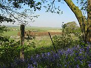
Northwood Hill RSPB Reserve
Northwood Hill RSPB Reserve lies to the north of the village, between High Halstow and CoolingCooling, Kent
Cooling is a village and civil parish on the Hoo Peninsula, overlooking the North Kent Marshes. According to the 2001 census the parish had a population of 209....
. It comprises 270 hectares (667 acres) of grazing marsh, woodland and farmland. Here is the largest heronry in Britain, where some 150-200 pairs nest. A heronry has been in the woods from at least 1947, when it was mentioned in a book on the Hundred of Hoo by Ralph Arnold. Many other birds, such as little egrets, avocets and marsh harriers, can also be seen in the reserve. This site was scheduled for demolition under government proposals for an international London airport in connection with the Thames Gateway
Thames Gateway
The Thames Gateway is an area of land stretching east from inner east London on both sides of the River Thames and the Thames Estuary. The area, which includes much brownfield land, has been designated a national priority for urban regeneration, taking advantage of the development opportunities...
.
Northwood Hill, or Northward, was known once locally as "the Norrards". Beyond it on the marsh is a disused experimental radar
Radar
Radar is an object-detection system which uses radio waves to determine the range, altitude, direction, or speed of objects. It can be used to detect aircraft, ships, spacecraft, guided missiles, motor vehicles, weather formations, and terrain. The radar dish or antenna transmits pulses of radio...
station, now part of the reserve.