
Thames Gateway
Encyclopedia
The Thames Gateway is an area of land stretching 70 kilometres (43.5 mi) east from inner east London on both sides of the River Thames
and the Thames Estuary
. The area, which includes much brownfield land
, has been designated a national priority for urban regeneration, taking advantage of the development opportunities realised by the completion of the High Speed 1 (officially known as the Channel Tunnel Rail Link) rail line. It stretches from Westferry in Tower Hamlets
to the Isle of Sheppey
and extends across three of the regions of England
. The development is delivered through regional development agencies, special purpose development corporations and local partnerships.
.
The area of brownfield land, farmland and marsh has been seen by successive governments and planners as having potential to act as a catalyst for the regeneration and growth and for the social advancement of the area, helping to alleviate some of the growth pressures on London and the South East. The government also believes that new private sector housing will reduce house price inflation. However, parts of the area are already densely populated with little scope for housing developments: Southend-on-Sea, for example, is the eighth most densely-populated district in the country outside London and further expansion is not possible owing to the river at the south, and its position in a conurbation that stretches almost to London already
: the London Development Agency
(LDA - part of the Greater London Authority
), the East of England
Development Agency (EEDA) and the South East England
Development Agency (SEEDA), as well as the national regeneration agency, English Partnerships
.
The Thames Gateway project aims to improve the economy of the region through the development of marshland, farmland and brownfield land, utilising major transport infrastructure provision, and through the renaissance of existing urban conurbations. Comparisons may be drawn with developments east of Paris
along the Marne
valley, but here a much greater area of land will be used.
. There have been substantial housing schemes at Chafford Hundred
, Chatham and Greenhithe
and there is a large shopping centre at Bluewater.
, which are recognised as an Environmentally Sensitive Area
by the Department for Environment, Food and Rural Affairs
and are largely covered by Sites of Special Scientific Interest. There are also fears of increased erosion. Opponents of development have argued that promoting the ecological significance of the area by increasing public accessibility to threatened marshes and wetlands, with improved transport corridors, will cause further erosion.
Proposals for a large international airport on Cliffe Marshes were dropped from the government's white paper on air transport in 2003 after they were rejected by local residents, the local council, as well as conservation charities such as the RSPB. The plan, which would have required the raising the ground level by 15 m. was also rejected by the Confederation of British Industry
as too expensive. However there is a judicial review underway looking at other options for airport expansion including the possibility of a floating airport off the Isle of Sheppey
.
The north of Kent
has historically been a marshland area and is under great pressure by developers. In addition to the great variety of wildlife found on and along the Thames, these marshes offer invaluable natural flood protection for London area, ever under threat of flooding. A current threat discussed at a public inquiry beginning in April 2007 is a rail freight depot proposed at Howbury near Slade Green
by ProLogis. This proposal implies development on an area of Crayford Marshes north of the present train sheds. The London Development Agency perceives some strategic merit in the proposals, although local councillors are not convinced that the depot would truly encourage train movements as an alternative to road haulage. This scepticism arises partly because the railways in the area are heavily used by scheduled passenger trains, to the extent that Crossrail
trains seem unlikely to progress to Dartford unless new tracks were laid to boost local rail capacity.
Dave Wardle, of the Environment Agency
, believes that "London and the Thames Estuary currently have one of the best tidal defence systems in the world". The Environment Agency assesses these systems will provide a high standard of protection well beyond 2030. However they also advise that future development in the Thames Gateway must go hand in hand with flood risk management, and take account of future plans for flood protection. The Agency insists it is important that effective flood risk management of the whole Estuary is not prejudiced by early decisions and development on the Gateway.
The Government has addressed some of these environmental concerns by designating the Thames Gateway as the UK's "eco-region", first announced in the 2007 Thames Gateway Delivery Plan. The objective of the "eco-region" is to protect and enhance the sustainability of the Thames Gateway, in terms of environmental quality, carbon reduction, and support for "green" economic development. This vision was elaborated in the 2008 Thames Gateway "eco-region prospectus", and implementation efforts are being led by the Homes and Communities Agency
with support across government and local stakeholders.
River Thames
The River Thames flows through southern England. It is the longest river entirely in England and the second longest in the United Kingdom. While it is best known because its lower reaches flow through central London, the river flows alongside several other towns and cities, including Oxford,...
and the Thames Estuary
Thames Estuary
The Thames Mouth is the estuary in which the River Thames meets the waters of the North Sea.It is not easy to define the limits of the estuary, although physically the head of Sea Reach, near Canvey Island on the Essex shore is probably the western boundary...
. The area, which includes much brownfield land
Brownfield land
Brownfield sites are abandoned or underused industrial and commercial facilities available for re-use. Expansion or redevelopment of such a facility may be complicated by real or perceived environmental contaminations. Cf. Waste...
, has been designated a national priority for urban regeneration, taking advantage of the development opportunities realised by the completion of the High Speed 1 (officially known as the Channel Tunnel Rail Link) rail line. It stretches from Westferry in Tower Hamlets
London Borough of Tower Hamlets
The London Borough of Tower Hamlets is a London borough to the east of the City of London and north of the River Thames. It is in the eastern part of London and covers much of the traditional East End. It also includes much of the redeveloped Docklands region of London, including West India Docks...
to the Isle of Sheppey
Isle of Sheppey
The Isle of Sheppey is an island off the northern coast of Kent, England in the Thames Estuary, some to the east of London. It has an area of . The island forms part of the local government district of Swale...
and extends across three of the regions of England
Regions of England
In England, the region is the highest tier of sub-national division used by central Government. Between 1994 and 2011, the nine regions had an administrative role in the implementation of UK Government policy, and as the areas covered by elected bodies...
. The development is delivered through regional development agencies, special purpose development corporations and local partnerships.
Scope
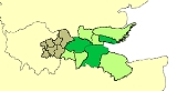
The Thames Gateway comprises sections of 16 different local government districts in three regions:| Region | Districts | 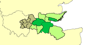 London borough London borough The administrative area of Greater London contains thirty-two London boroughs. Inner London comprises twelve of these boroughs plus the City of London. Outer London comprises the twenty remaining boroughs of Greater London.-Functions:... s (brown), non-metropolitan district Non-metropolitan district Non-metropolitan districts, or colloquially shire districts, are a type of local government district in England. As created, they are sub-divisions of non-metropolitan counties in a so-called "two-tier" arrangement... s (green) and unitary authorities Unitary authority A unitary authority is a type of local authority that has a single tier and is responsible for all local government functions within its area or performs additional functions which elsewhere in the relevant country are usually performed by national government or a higher level of sub-national... (dark green). |
|---|---|
| London Greater London Greater London is the top-level administrative division of England covering London. It was created in 1965 and spans the City of London, including Middle Temple and Inner Temple, and the 32 London boroughs. This territory is coterminate with the London Government Office Region and the London... |
From the North East and South East London sub region, the London boroughs of Barking and Dagenham London Borough of Barking and Dagenham In 1801, the civil parishes that form the modern borough had a total population of 1,937; and the area was characterised by farming, woodland and the fishing fleet at Barking. This last industry employed 1,370 men and boys by 1850, but by the end of the century had ceased to exist; replaced by... , Bexley London Borough of Bexley The London Borough of Bexley lies in south east Greater London, and is a borough referred to as part of Outer London. It has common borders with the London Borough of Bromley to the south, the London Borough of Greenwich to the west, across the River Thames to the north it borders the London... , Havering London Borough of Havering The London Borough of Havering is a London borough in North East London, England and forms part of Outer London. The principal town in Havering is Romford and the other main communities are Hornchurch, Upminster and Rainham. The borough is mainly characterised by suburban development with large... , Lewisham London Borough of Lewisham The London Borough of Lewisham is a London borough in south-east London, England and forms part of Inner London. The principal settlement of the borough is Lewisham... , Greenwich London Borough of Greenwich The London Borough of Greenwich is an Inner London borough in south-east London, England. Taking its name from the historic town of Greenwich, the present borough was formed in 1965 by the amalgamation of the former area of the Metropolitan Borough of Greenwich with part of the Metropolitan... , Newham London Borough of Newham The London Borough of Newham is a London borough formed from the towns of West Ham and East Ham, within East London.It is situated east of the City of London, and is north of the River Thames. According to 2006 estimates, Newham has one of the highest ethnic minority populations of all the... and Tower Hamlets London Borough of Tower Hamlets The London Borough of Tower Hamlets is a London borough to the east of the City of London and north of the River Thames. It is in the eastern part of London and covers much of the traditional East End. It also includes much of the redeveloped Docklands region of London, including West India Docks... |
| East East of England The East of England is one of the nine official regions of England. It was created in 1994 and was adopted for statistics from 1999. It includes the ceremonial counties of Essex, Hertfordshire, Bedfordshire, Cambridgeshire, Norfolk and Suffolk. Essex has the highest population in the region.Its... |
Essex Essex Essex is a ceremonial and non-metropolitan county in the East region of England, and one of the home counties. It is located to the northeast of Greater London. It borders with Cambridgeshire and Suffolk to the north, Hertfordshire to the west, Kent to the South and London to the south west... non-metropolitan districts of Basildon Basildon (district) Basildon is a local government district in south Essex in the East of England, centred around the town of Basildon. The district was formed under the Local Government Act 1972 on 1 April 1974 from the former area of Basildon Urban District and the part of Thurrock Urban District that was within the... , Castle Point Castle Point Castle Point is a local government district and borough in south Essex. The borough comprises the towns of Canvey Island, Hadleigh, South Benfleet, and Thundersley which also provides the site of the council headquarters.-History:... and Rochford Rochford Rochford is a small town in the Rochford district of Essex in the East of England. It is sited about 43 miles from Central London and approximately 21 miles from the Essex county town, Chelmsford... ; and the unitary authorities of Thurrock Thurrock Thurrock is a unitary authority with borough status in the English ceremonial county of Essex. It is part of the London commuter belt and an area of regeneration within the Thames Gateway redevelopment zone. The local authority is Thurrock Council.... and Southend-on-Sea Southend-on-Sea Southend-on-Sea is a unitary authority area, town, and seaside resort in Essex, England. The district has Borough status, and comprises the towns of Chalkwell, Eastwood, Leigh-on-Sea, North Shoebury, Prittlewell, Shoeburyness, Southchurch, Thorpe Bay, and Westcliff-on-Sea. The district is situated... |
| South East South East England South East England is one of the nine official regions of England, designated in 1994 and adopted for statistical purposes in 1999. It consists of Berkshire, Buckinghamshire, East Sussex, Hampshire, Isle of Wight, Kent, Oxfordshire, Surrey and West Sussex... |
Kent Kent Kent is a county in southeast England, and is one of the home counties. It borders East Sussex, Surrey and Greater London and has a defined boundary with Essex in the middle of the Thames Estuary. The ceremonial county boundaries of Kent include the shire county of Kent and the unitary borough of... non-metropolitan districts of Dartford Dartford (borough) Dartford is the name given to a local government district and borough in north west Kent, England, which takes its name from its administrative capital. It borders Thurrock, to the north across the River Thames; to the west lies the London Borough of Bexley; to the south Sevenoaks district; and the... , Gravesham Gravesham Gravesham is a local government district and borough in North West Kent, England. It has borders with the River Thames to the north; the City of Rochester and Medway to the east; the borough of Tonbridge and Malling ; and the boroughs of Sevenoaks and Dartford to the west.Its council is based at... and western parts of Swale Swale Swale is a local government district with borough status in Kent, England. Its council is based in Sittingbourne. The borough is named after the narrow channel called The Swale, a channel that separates the mainland of Kent from the Isle of Sheppey, and which occupies the central part of the... ; and the unitary authority of Medway Medway Medway is a conurbation and unitary authority in South East England. The Unitary Authority was formed in 1998 when the City of Rochester-upon-Medway amalgamated with Gillingham Borough Council and part of Kent County Council to form Medway Council, a unitary authority independent of Kent County... |
Profile
The area accommodates around 1.6 million people and contains some of the most deprived wards in the country, characterised by lack of access to public transport, services, employment and affordable quality housing. Its boundary was drawn to capture the riverside strip that formerly hosted many land extensive industries, serving London and the South East, whose decline has left a legacy of large scale dereliction and contaminated land, such as around TilburyTilbury
Tilbury is a town in the borough of Thurrock, Essex, England. As a settlement it is of relatively recent existence, although it has important historical connections, being the location of a 16th century fort and an ancient cross-river ferry...
.
The area of brownfield land, farmland and marsh has been seen by successive governments and planners as having potential to act as a catalyst for the regeneration and growth and for the social advancement of the area, helping to alleviate some of the growth pressures on London and the South East. The government also believes that new private sector housing will reduce house price inflation. However, parts of the area are already densely populated with little scope for housing developments: Southend-on-Sea, for example, is the eighth most densely-populated district in the country outside London and further expansion is not possible owing to the river at the south, and its position in a conurbation that stretches almost to London already
Administration
The Department for Communities and Local Government is responsible for co-ordinating the project and development will be largely delivered by the three regional development agenciesRegional Development Agency
In the United Kingdom, a regional development agency is a non-departmental public body established for the purpose of development, primarily economic, of one of England's Government Office regions. There is one RDA for each of the NUTS level 1 regions of England...
: the London Development Agency
London Development Agency
The London Development Agency is the Regional Development Agency for Greater London, England. It is a functional body of the Greater London Authority...
(LDA - part of the Greater London Authority
Greater London Authority
The Greater London Authority is the top-tier administrative body for Greater London, England. It consists of a directly elected executive Mayor of London, currently Boris Johnson, and an elected 25-member London Assembly with scrutiny powers...
), the East of England
East of England
The East of England is one of the nine official regions of England. It was created in 1994 and was adopted for statistics from 1999. It includes the ceremonial counties of Essex, Hertfordshire, Bedfordshire, Cambridgeshire, Norfolk and Suffolk. Essex has the highest population in the region.Its...
Development Agency (EEDA) and the South East England
South East England
South East England is one of the nine official regions of England, designated in 1994 and adopted for statistical purposes in 1999. It consists of Berkshire, Buckinghamshire, East Sussex, Hampshire, Isle of Wight, Kent, Oxfordshire, Surrey and West Sussex...
Development Agency (SEEDA), as well as the national regeneration agency, English Partnerships
English Partnerships
English Partnerships was the national regeneration agency for England, performing a similar role on a national level to that fulfilled by Regional Development Agencies on a regional level...
.
The Thames Gateway project aims to improve the economy of the region through the development of marshland, farmland and brownfield land, utilising major transport infrastructure provision, and through the renaissance of existing urban conurbations. Comparisons may be drawn with developments east of Paris
Paris
Paris is the capital and largest city in France, situated on the river Seine, in northern France, at the heart of the Île-de-France region...
along the Marne
Marne
Marne is a department in north-eastern France named after the river Marne which flows through the department. The prefecture of Marne is Châlons-en-Champagne...
valley, but here a much greater area of land will be used.
Redevelopment zones
The development is split into zones each with a different agency responsible for delivery. The zones are:| Region | Zones | Delivery agencies |
|---|---|---|
| London |
|
London Thames Gateway Development Corporation London Thames Gateway Development Corporation The London Thames Gateway Development Corporation is a non-departmental public body sponsored by the Department for Communities and Local Government, with directors appointed by the Secretary of State, including some democratically elected councillors... |
|
Greenwich Peninsula Greenwich Peninsula is an area of South London, England, located in the London Borough of Greenwich.The peninsula is bounded on three sides by a loop of the Thames, between the Isle of Dogs and Silvertown. To the south is the rest of Greenwich, to the south-east is Charlton.The peninsula lies... |
Greenwich Partnership and Bexley Partnership | |
| South East |
Dartford (borough) Dartford is the name given to a local government district and borough in north west Kent, England, which takes its name from its administrative capital. It borders Thurrock, to the north across the River Thames; to the west lies the London Borough of Bexley; to the south Sevenoaks district; and the... and Gravesham Gravesham Gravesham is a local government district and borough in North West Kent, England. It has borders with the River Thames to the north; the City of Rochester and Medway to the east; the borough of Tonbridge and Malling ; and the boroughs of Sevenoaks and Dartford to the west.Its council is based at... ) GRAIN GRAIN is a small international non-profit organisation that works to support small farmers and social movements in their struggles for community-controlled and biodiversity-based food systems. Our support takes the form of independent research and analysis, networking at local, regional and... Medway Medway is a conurbation and unitary authority in South East England. The Unitary Authority was formed in 1998 when the City of Rochester-upon-Medway amalgamated with Gillingham Borough Council and part of Kent County Council to form Medway Council, a unitary authority independent of Kent County... |
Kent Thameside Delivery Board, Medway Renaissance Partnership, Swale Forward |
| East |
Thurrock Thurrock is a unitary authority with borough status in the English ceremonial county of Essex. It is part of the London commuter belt and an area of regeneration within the Thames Gateway redevelopment zone. The local authority is Thurrock Council.... Basildon Basildon is a town located in the Basildon District of the county of Essex, England.It lies east of Central London and south of the county town of Chelmsford... and Castle Point |
Thurrock Thames Gateway Development Corporation, Basildon Renaissance Partnership and Renaissance Southend |
Developments
Before 2003 most conspicuous development was situated west of BecktonBeckton
Beckton is part of the London Borough of Newham, England, located east of Charing Cross.Its boundaries are the A13 trunk road to the north, Barking Creek to the east, the Royal Docks to the south, and Prince Regent Lane to the west. The area around Prince Regent Lane is also known as Custom House...
. There have been substantial housing schemes at Chafford Hundred
Chafford Hundred
Chafford Hundred is a recent UK housing brownfield just outside Greater London between Grays and South Ockendon in the Borough of Thurrock. It is immediately adjacent to Lakeside Shopping Centre and West Thurrock...
, Chatham and Greenhithe
Greenhithe
Greenhithe is a town in Dartford District of Kent, England. It forms part of the civil parish of Swanscombe and Greenhithe.Greenhithe, as it is spelled today, is located where it was possible to build wharves for transshipping corn, wood and other commodities; its largest cargoes were of chalk and...
and there is a large shopping centre at Bluewater.
| Region | Project | Description | Status |
|---|---|---|---|
| London, East, South East | High Speed 1 | High speed rail line linking Stratford Stratford International station Stratford International station is a main line railway and Docklands Light Railway station located in Stratford in the London Borough of Newham in northeast London, United Kingdom... and Ebbsfleet Ebbsfleet International railway station Ebbsfleet International railway station is a railway station in Ebbsfleet Valley, in the Borough of Dartford, Kent, 10 miles outside the eastern boundary of Greater London, England. It is near Dartford and the Bluewater shopping centre to the west and Gravesend to the east. Ebbsfleet International... stations in the Gateway area to central London and continental Europe. |
Fully operational. |
| London | Thames Gateway Bridge Thames Gateway Bridge The Thames Gateway Bridge was a proposed crossing over the River Thames in east London, England. It was first mooted in the 1970s but never came to fruition... |
Road bridge between Beckton and Thamesmead near to the existing Woolwich Ferry Woolwich Ferry The Woolwich Free Ferry is a boat service across the River Thames, London, UK, which is licensed and financed by London River Services, the maritime arm of Transport for London... . Designed to provide segregated bus, tram or DLR carriage. |
Cancelled |
| London | Stratford City Stratford City Westfield Stratford City is a shopping centre in Stratford, London, owned by the Westfield Group. The centre opened on 13 September 2011. With a total retail floor area of , it is one of the largest urban shopping centres in Europe. It is the 3rd largest shopping centre in the United Kingdom by... |
73 hectares (0.73 square km) (180 acre Acre The acre is a unit of area in a number of different systems, including the imperial and U.S. customary systems. The most commonly used acres today are the international acre and, in the United States, the survey acre. The most common use of the acre is to measure tracts of land.The acre is related... ) mixed use site of 100 shops, three large department stores, cafés, schools, hotels, parks and health centres. 11,000 residents and 30,000 workers. Part of the site will be used for the Olympics and will be converted after 2012. |
Under construction. |
| London | East London Transit East London Transit East London Transit is a part-segregated bus rapid transit whose first phase opened in 2010, with an additional phase planned to open in 2013. The scheme has been developed by Transport for London due to the existing and anticipated demand for public transport in northeast London caused by the... |
The East London Transit is an intermodal transport scheme to connect housing developments to rail and tube. | Phase I opened Feb 2010. |
| London | White Hart Triangle | Mainly derelict land close to Plumstead railway station Plumstead railway station Plumstead railway station serves the suburb of Plumstead, in the London Borough of Greenwich, east of Woolwich Arsenal. It is served by Southeastern.... being developed with the aim of creating 2000 new jobs, with funding from the London Development Agency London Development Agency The London Development Agency is the Regional Development Agency for Greater London, England. It is a functional body of the Greater London Authority... and European Union European Union The European Union is an economic and political union of 27 independent member states which are located primarily in Europe. The EU traces its origins from the European Coal and Steel Community and the European Economic Community , formed by six countries in 1958... . |
Currently Under Construction |
| East | London Gateway London Gateway London Gateway is a major new development under construction on the north bank of the River Thames in Thurrock, Essex. It comprises a large new deep-water port, which will be able to handle the biggest container ships in the world, as well as one of Europe’s largest logistics parks, providing... |
The development is a world class port, and a logistics and business park. The port will be developed at Shell Haven Shell Haven Shell Haven was a port on the north bank of the Thames Estuary at the eastern end of Thurrock, Essex, England and then an oil refinery. The refinery closed in 1999 and the site was purchased by DP World who received planning consent in May 2007 for the new London Gateway deep water container port... , a 607 hectare Hectare The hectare is a metric unit of area defined as 10,000 square metres , and primarily used in the measurement of land. In 1795, when the metric system was introduced, the are was defined as being 100 square metres and the hectare was thus 100 ares or 1/100 km2... (6 km2) (1,500 acre Acre The acre is a unit of area in a number of different systems, including the imperial and U.S. customary systems. The most commonly used acres today are the international acre and, in the United States, the survey acre. The most common use of the acre is to measure tracts of land.The acre is related... ) site in Thurrock. The two schemes are expected to create up to 16,500 new jobs. |
Port due to open 2011, business park 2008 |
| East | Southend-on-Sea | The council is using money provided through the scheme to redevelop the town centre and seafront and create a "transport corridor" along the A13. | |
| East | Basildon District Basildon (district) Basildon is a local government district in south Essex in the East of England, centred around the town of Basildon. The district was formed under the Local Government Act 1972 on 1 April 1974 from the former area of Basildon Urban District and the part of Thurrock Urban District that was within the... |
£2 billion major developments planned. These include the regeneration of Basildon, Wickford, Pitsea and Laindon town centres; a new sporting village, a health and education research centre, investment in the Basildon Enterprise Corridor business area, a wetland nature reserves in the Thames Marshes and investment in housing estates such as Craylands, Five Links and Felmores. | |
| South East | Ebbsfleet Valley Ebbsfleet Valley Ebbsfleet Valley is a new town and redevelopment area in Kent, South East England; and part of the Thames Gateway. It is located south west of Gravesend.It is named after the valley of the Ebbsfleet River, which it straddles... |
Ebbsfleet Valley is planned in the area around Ebbsfleet International station. It consists of over 790,000 square metre (8.5 million sq ft) of mixed-use development, including housing, retail, residential, hotel and leisure sites. According to a May 2007 press release from Land Securities, an "iconic landmark for Kent" will be planned here. A 50-metre high sculpture is planned to landmark Ebbsfleet and Ebbsfleet Valley Ebbsfleet Valley Ebbsfleet Valley is a new town and redevelopment area in Kent, South East England; and part of the Thames Gateway. It is located south west of Gravesend.It is named after the valley of the Ebbsfleet River, which it straddles... , estimated to cost £2 million. |
|
| South East | Swanscombe Peninsula Swanscombe Swanscombe is a small town, part of the Borough of Dartford on the north Kent coast in England. It is part of the civil parish of Swanscombe and Greenhithe.-Prehistory:... |
Previously the location of the Swanscombe Cement Works, this 130 hectare Hectare The hectare is a metric unit of area defined as 10,000 square metres , and primarily used in the measurement of land. In 1795, when the metric system was introduced, the are was defined as being 100 square metres and the hectare was thus 100 ares or 1/100 km2... (1.3 square km) (320 acre Acre The acre is a unit of area in a number of different systems, including the imperial and U.S. customary systems. The most commonly used acres today are the international acre and, in the United States, the survey acre. The most common use of the acre is to measure tracts of land.The acre is related... ) site, partly in both Dartford and Gravesham, is planned to have 2,700 homes and 500000 sq ft (46,451.5 m²) of office space. |
|
| South East | The Bridge | Lying close to the Queen Elizabeth II Bridge Queen Elizabeth II Bridge The Queen Elizabeth II Bridge is a high and long cable-stayed road bridge across the River Thames in south east England. It was opened in 1991 by Her Majesty Queen Elizabeth II.... on and around the site of the former Joyce Green Hospital, this 107 hectare Hectare The hectare is a metric unit of area defined as 10,000 square metres , and primarily used in the measurement of land. In 1795, when the metric system was introduced, the are was defined as being 100 square metres and the hectare was thus 100 ares or 1/100 km2... (1 km²) (264 acre Acre The acre is a unit of area in a number of different systems, including the imperial and U.S. customary systems. The most commonly used acres today are the international acre and, in the United States, the survey acre. The most common use of the acre is to measure tracts of land.The acre is related... ) development will have 1.5 million square feet (140,000 m²) of business space and 1500 residences. |
|
| South East | Dartford Northern Gateway | In early 2006 SEEDA South East England Development Agency SEEDA, more officially the South East England Development Agency, is one of a number of regional development agencies in England. It was set up as a non-departmental public body in 1999 to promote the region and to enable a number of more difficult regeneration projects which otherwise might not... (The South East England Development Agency) purchased a 2.6 hectare site on the edge of Dartford which had been used by Unwins, an off-license chain, which went into administration in 2005. They also purchased the neighbouring Matrix Business Centre to protect its future. They intend to develop the site with a mixture of retail and other businesses and housing. It is also the home to The Orchestra of the Thames Gateway, an organisation that has given more than 230 performances in the Gateway area up until the end of 2009. |
|
| South East | Stone Castle | It is located to the north of Bluewater Shopping Centre and will be a mix of residences, a new publicly accessible linear park in St Clement's Valley and a high quality business park set back from St Clement's Way. Phase 1 is known as Waterstone Park, where about 200 of an eventual 650 residences have been built. | |
| South East | Northfleet Embankment | An industrial site of 74 hectares (0.74 km²) with 1.9 km of river frontage. Key sites have been acquired by SEEDA South East England Development Agency SEEDA, more officially the South East England Development Agency, is one of a number of regional development agencies in England. It was set up as a non-departmental public body in 1999 to promote the region and to enable a number of more difficult regeneration projects which otherwise might not... to prepare for the re-development of the area, which could potentially begin once the Northfleet Cement Works moves to the Medway Valley in 2008. |
|
| South East | Chatham Town Centre & Waterfront | Projected to deliver 1500 new homes, plus a variety of other projects, including the Dickens World Dickens World Dickens World is a themed attraction located at Chatham Dockyard in the English county of Kent. Privately funded, it cost £62 million to create, and was opened to the public on 25 May 2007.-The concept:... tourist attraction (opened May 2007); the Great Lines City Park; refurbishment and expansion of the Pentagon shopping centre with 1,4000 square metres of new stores and leisure facilities; a new 'cultural quarter' centred on Medway REACH, a new 2000 seat auditorium Auditorium An auditorium is a room built to enable an audience to hear and watch performances at venues such as theatres. For movie theaters, the number of auditoriums is expressed as the number of screens.- Etymology :... . Funding is being sought for a cable car system across the River Medway River Medway The River Medway, which is almost entirely in Kent, England, flows for from just inside the West Sussex border to the point where it enters the Thames Estuary.... . |
|
| South East | Gillingham Waterfront | 1000 new residences and 200 new jobs are projected to be created on this 32 hectare site by 2010. | |
| South East | Rochester Riverside | Key sites have been acquired by Medway Medway Medway is a conurbation and unitary authority in South East England. The Unitary Authority was formed in 1998 when the City of Rochester-upon-Medway amalgamated with Gillingham Borough Council and part of Kent County Council to form Medway Council, a unitary authority independent of Kent County... Council and other areas are being acquired SEEDA South East England Development Agency SEEDA, more officially the South East England Development Agency, is one of a number of regional development agencies in England. It was set up as a non-departmental public body in 1999 to promote the region and to enable a number of more difficult regeneration projects which otherwise might not... to prepare for the re-development of the area, with 30 hectares being cleared and decontaminated. Proposed plans include 1700 new residences, with building work projected to start in 2008. 2.5 kilometres of new river wall are being constructed, with the site also being raised by 2 metres. |
|
| South East | Strood Riverside | About 500 new homes, improved waterfront access and improved flood defences, with completion projected by 2012. | |
| South East | Temple Waterfront | A 21 hectare site with a possible 600 new homes and part of the waterfront designated for nature conservation. According to Medway Renaissance, the potential for a new railway station is being investigated. |
Environmental implications
The Thames Gateway project proposes removing parts of and building on the North Kent MarshesNorth Kent Marshes
The North Kent Marshes, located in the north of the county of Kent on the Thames Estuary in south-east England, is one of 22 Environmentally Sensitive Areas recognised by the UK government's Department for Environment, Food and Rural Affairs...
, which are recognised as an Environmentally Sensitive Area
Environmentally Sensitive Area
An Environmentally Sensitive Area is a type of designation for an agricultural area which needs special protection because of its landscape, wildlife or historical value. The scheme was introduced in 1987...
by the Department for Environment, Food and Rural Affairs
Department for Environment, Food and Rural Affairs
The Department for Environment, Food and Rural Affairs is the government department responsible for environmental protection, food production and standards, agriculture, fisheries and rural communities in the United Kingdom...
and are largely covered by Sites of Special Scientific Interest. There are also fears of increased erosion. Opponents of development have argued that promoting the ecological significance of the area by increasing public accessibility to threatened marshes and wetlands, with improved transport corridors, will cause further erosion.
Proposals for a large international airport on Cliffe Marshes were dropped from the government's white paper on air transport in 2003 after they were rejected by local residents, the local council, as well as conservation charities such as the RSPB. The plan, which would have required the raising the ground level by 15 m. was also rejected by the Confederation of British Industry
Confederation of British Industry
The Confederation of British Industry is a British not for profit organisation incorporated by Royal charter which promotes the interests of its members, some 200,000 British businesses, a figure which includes some 80% of FTSE 100 companies and around 50% of FTSE 350 companies.-Role:The CBI works...
as too expensive. However there is a judicial review underway looking at other options for airport expansion including the possibility of a floating airport off the Isle of Sheppey
Isle of Sheppey
The Isle of Sheppey is an island off the northern coast of Kent, England in the Thames Estuary, some to the east of London. It has an area of . The island forms part of the local government district of Swale...
.
The north of Kent
Kent
Kent is a county in southeast England, and is one of the home counties. It borders East Sussex, Surrey and Greater London and has a defined boundary with Essex in the middle of the Thames Estuary. The ceremonial county boundaries of Kent include the shire county of Kent and the unitary borough of...
has historically been a marshland area and is under great pressure by developers. In addition to the great variety of wildlife found on and along the Thames, these marshes offer invaluable natural flood protection for London area, ever under threat of flooding. A current threat discussed at a public inquiry beginning in April 2007 is a rail freight depot proposed at Howbury near Slade Green
Slade Green
Slade Green is a place in south- east London closer to the edge of London located in the London Borough of Bexley. It is a suburban development situated east-southeast of Charing Cross and lying south of the River Thames slightly to the west of the River Darenth and River Cray.-History and...
by ProLogis. This proposal implies development on an area of Crayford Marshes north of the present train sheds. The London Development Agency perceives some strategic merit in the proposals, although local councillors are not convinced that the depot would truly encourage train movements as an alternative to road haulage. This scepticism arises partly because the railways in the area are heavily used by scheduled passenger trains, to the extent that Crossrail
Crossrail
Crossrail is a project to build a major new railway link under central London. The name refers to the first of two routes which are the responsibility of Crossrail Ltd. It is based on an entirely new east-west tunnel with a central section from to Liverpool Street station...
trains seem unlikely to progress to Dartford unless new tracks were laid to boost local rail capacity.
Dave Wardle, of the Environment Agency
Environment Agency
The Environment Agency is a British non-departmental public body of the Department for Environment, Food and Rural Affairs and an Assembly Government Sponsored Body of the Welsh Assembly Government that serves England and Wales.-Purpose:...
, believes that "London and the Thames Estuary currently have one of the best tidal defence systems in the world". The Environment Agency assesses these systems will provide a high standard of protection well beyond 2030. However they also advise that future development in the Thames Gateway must go hand in hand with flood risk management, and take account of future plans for flood protection. The Agency insists it is important that effective flood risk management of the whole Estuary is not prejudiced by early decisions and development on the Gateway.
The Government has addressed some of these environmental concerns by designating the Thames Gateway as the UK's "eco-region", first announced in the 2007 Thames Gateway Delivery Plan. The objective of the "eco-region" is to protect and enhance the sustainability of the Thames Gateway, in terms of environmental quality, carbon reduction, and support for "green" economic development. This vision was elaborated in the 2008 Thames Gateway "eco-region prospectus", and implementation efforts are being led by the Homes and Communities Agency
Homes and Communities Agency
The Homes and Communities Agency is the non-departmental public body that funds new affordable housing in England. It was established by the Housing and Regeneration Act 2008 as one of the successor bodies to the Housing Corporation, and became operational on 1 December 2008.-Background:On 17...
with support across government and local stakeholders.
External links
- Thames Gateway News website, updated daily
- Press release of Barker Report on the economic effects of building more houses in south-east England. HM Treasury, 2004. Retrieved 26 December 2005.
- The Future Development of Air Transport in the United Kingdom: South East. Department for Transport (UK), 2001. Retrieved 26 December 2005.
- Clark, Andrew (16 December 2002). Thumbs down to Kent airport. The Guardian (UK national title)
- London Thames Gateway Forum
- Thames Gateway Internet TV
- Thames Gateway London Partnership
- Essex Thames Gateway Information Group
- Wildlife Gateway - Providing a resource for information on development with wildlife in mind
- LDA report on proposed Howbury rail depot
- Thames Gateway South Essex Partnership
- Thames Gateway Kent Partnership
- Greengrid - Connecting green spaces in South Essex
- The Office of the Deputy Prime Minister
- London's 2012 Olympic Bid
- Thames Gateway and the Olympics: Parkland Vision
- Thames Gateway Forum
- Maps of the area
- floating city project in the Thames Estuary
- Medway Renaissance
- SEEDA - the South East England Development AgencySouth East England Development AgencySEEDA, more officially the South East England Development Agency, is one of a number of regional development agencies in England. It was set up as a non-departmental public body in 1999 to promote the region and to enable a number of more difficult regeneration projects which otherwise might not...
- Basildon Renaissance Partnership
- Invest Thames Gateway website
- Thames Gateway Delivery Plan