
Hellas quadrangle
Encyclopedia
The Hellas quadrangle
is one of a series of 30 quadrangle maps of Mars used by the United States Geological Survey
(USGS) Astrogeology Research Program
. The Hellas quadrangle is also referred to as MC-28 (Mars Chart-28).
The Hellas quadrangle covers the area from 240° to 300° west longitude and 30° to 65° south latitude on the planet Mars
. Within the Hellas quadrangle lies the classic features Hellas Planitia
and Promethei Terra
. Many interesting and mysterious features have been discovered in the Hellas quadrangle, including the giant river valleys Dao Vallis,Niger Vallis, Harmakhis, and Reull Vallis—all of which may have contributed water to a lake in the Hellas basin in the distant past.

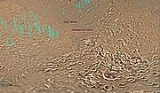
 The Hellas quadrangle contains part of the Hellas Basin, the largest known impact crater on the surface of Mars and the second largest in the solar system. The basin is located in the southern highlands of Mars and is thought to have been formed about 3.9 billion years ago, during the Late Heavy Bombardment. Studies suggest that when an impact created the Hellas Basin, the entire surface of Mars was heated hundreds of degrees, 70 meters of molted rock fell on the planet, and an atmosphere of gaseous rock was formed. This rock atmosphere was 10 times as thick as the Earth's atmosphere. In a few days, the rock would have condensed out and covered the whole planet with an additional 10 m of molten rock. In the Northwest portion of Hellas Planitia
is a strange type of surface called complex banded terrain or taffy-pull terrain. Its process of formation is still largely unknown, although it appears to be due to erosion of hard and soft sediment along with ductile deformation. Ductile deformation results from layers undergoing strain.
Early in the planet's history, it is believed that a giant lake existed in the Hellas Basin. Possible shorelines have been discovered. Glacial features (terminal moraines, drumlins, and eskers) have been found that may have been formed when the water froze.
(LDA's). Recently, research with the Shallow Radar on the Mars Reconnaissance Orbiter
has provided strong evidence that the LDA's are glacier
s that are covered with a thin layer of rocks. Large amounts of water ice are believed to be in the LDA's. Available evidence strongly suggests that the eastern part of Hellas accumulated snow in the past. When the tilt (obliquity) of Mars increases the southern ice cap releases large amounts of water vapor. Climate models predict that when this occurs, water vapor condenses and falls where LDAs are located. The tilt of the earth changes little because our relatively large moon keeps it stable. The two tiny Martian moons do not stabilize their planet, so the rotational axis of Mars undergoes large variations. Lobate Debris Approns may be a major source of water for future Mars colonists. Their major advantage over other sources of Martian water are that they can easily mapped from orbit and they are closer to the equator where manned missions are more likely to land.
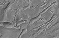
 Much of the surface of Mars is covered by a thick smooth mantle that is thought to be a mixture of ice and dust. This ice-rich mantle, a few yards thick, smoothes the land, but in places it displays a bumpy texture, resembling the surface of a basketball. Because there are few craters on this mantle, the mantle is relatively young. The image at the right shows a good view of this smooth mantle around Niger Vallis
, as observed with HiRISE
.
Changes in Mars's orbit and tilt cause significant changes in the distribution of water ice from polar regions down to latitudes equivalent to Texas. During certain climate periods water vapor leaves polar ice and enters the atmosphere. The water returns to the ground at lower latitudes as deposits of frost or snow mixed generously with dust. The atmosphere of Mars contains a great deal of fine dust particles. Water vapor condenses on the particles, then they fall down to the ground due to the additional weight of the water coating. When ice at the top of the mantling layer goes back into the atmosphere, it leaves behind dust, which insulates the remaining ice.
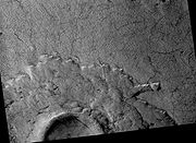
 Dao Vallis begins near a large volcano, called Hadriaca Patera, so it is thought to have received water when hot magma
melted huge amounts of ice in the frozen ground. The partially circular depressions on the left side of the channel in the image to the right suggests that groundwater sapping also contributed water.
 Many areas on Mars, including the Hellas quadrangle, experience the passage of giant dust devils
. A thin coating of fine bright dust covers most of the martian surface. When a dust devil goes by it blows away the coating and exposes the underlying dark surface. Dust devils have been seen from the ground and from orbiting spacecraft. They have even blown the dust off of the solar panels of the two Rover
s on Mars, thereby greatly extending their lives. The twin Rovers were designed to last for 3 months, instead they have lasted more than five years and are still going. The pattern of the tracks have been shown to change every few months.
 The Mars Reconnaissance Orbiter
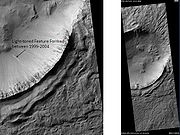
discovered changes on the wall of Penticton Crater
between 1999 and 2004. One interpretation of the changes was that they were caused by water flowing on the surface. A further analysis, published about a year later, revealed that the deposit could have been caused by gravity moving material down slope. The slope where the deposit was sighted was close to the stability limits of dry, unconsolidated materials.
Quadrangle (geography)
In geology or geography, the word "quadrangle" usually refers to a United States Geological Survey 7.5-minute quadrangle map, which are usually named after a local physiographic feature. The shorthand "quad" is also used, especially with the name of the map; for example, "the Ranger Creek, Texas...
is one of a series of 30 quadrangle maps of Mars used by the United States Geological Survey
United States Geological Survey
The United States Geological Survey is a scientific agency of the United States government. The scientists of the USGS study the landscape of the United States, its natural resources, and the natural hazards that threaten it. The organization has four major science disciplines, concerning biology,...
(USGS) Astrogeology Research Program
Astrogeology Research Program
The USGS Astrogeology Science Center has a rich history of participation in space exploration efforts and planetary mapping, starting in 1963 when the Flagstaff Science Center was established by Gene Shoemaker to provide lunar geologic mapping and assist in training astronauts destined for the...
. The Hellas quadrangle is also referred to as MC-28 (Mars Chart-28).
The Hellas quadrangle covers the area from 240° to 300° west longitude and 30° to 65° south latitude on the planet Mars
Mars
Mars is the fourth planet from the Sun in the Solar System. The planet is named after the Roman god of war, Mars. It is often described as the "Red Planet", as the iron oxide prevalent on its surface gives it a reddish appearance...
. Within the Hellas quadrangle lies the classic features Hellas Planitia
Hellas Planitia
Hellas Planitia, also known as the Hellas Impact Basin, is a huge, roughly circular impact basin located in the southern hemisphere of the planet Mars. It is the second or third largest impact crater and the largest visible impact crater known in the Solar System...
and Promethei Terra
Promethei Terra
Promethei Terra is a large Martian region, centered at and covering 3300 km at its broadest extent. It lies to the east of the massive Hellas basin. Like much of the southern part of the planet it is a heavily cratered, highland region. Promethei Terra was named for a classic albedo feature...
. Many interesting and mysterious features have been discovered in the Hellas quadrangle, including the giant river valleys Dao Vallis,Niger Vallis, Harmakhis, and Reull Vallis—all of which may have contributed water to a lake in the Hellas basin in the distant past.
Hellas Basin
Hellas Planitia
Hellas Planitia, also known as the Hellas Impact Basin, is a huge, roughly circular impact basin located in the southern hemisphere of the planet Mars. It is the second or third largest impact crater and the largest visible impact crater known in the Solar System...
is a strange type of surface called complex banded terrain or taffy-pull terrain. Its process of formation is still largely unknown, although it appears to be due to erosion of hard and soft sediment along with ductile deformation. Ductile deformation results from layers undergoing strain.
Early in the planet's history, it is believed that a giant lake existed in the Hellas Basin. Possible shorelines have been discovered. Glacial features (terminal moraines, drumlins, and eskers) have been found that may have been formed when the water froze.
Lobate Debris Aprons
One very important feature common in east Hellas are piles of material surrounding cliffs. The formation is called a Lobate Debris ApronLobate Debris Apron
Lobate debris aprons are geological features on Mars, first seen by the Viking Orbiters, consisting of piles of rock debris below cliffs. These features have a convex topography and a gentle slope from cliffs or escarpments, which suggest flow away from the steep source cliff...
(LDA's). Recently, research with the Shallow Radar on the Mars Reconnaissance Orbiter
Mars Reconnaissance Orbiter
Mars Reconnaissance Orbiter is a NASA multipurpose spacecraft designed to conduct reconnaissance and Exploration of Mars from orbit...
has provided strong evidence that the LDA's are glacier
Glacier
A glacier is a large persistent body of ice that forms where the accumulation of snow exceeds its ablation over many years, often centuries. At least 0.1 km² in area and 50 m thick, but often much larger, a glacier slowly deforms and flows due to stresses induced by its weight...
s that are covered with a thin layer of rocks. Large amounts of water ice are believed to be in the LDA's. Available evidence strongly suggests that the eastern part of Hellas accumulated snow in the past. When the tilt (obliquity) of Mars increases the southern ice cap releases large amounts of water vapor. Climate models predict that when this occurs, water vapor condenses and falls where LDAs are located. The tilt of the earth changes little because our relatively large moon keeps it stable. The two tiny Martian moons do not stabilize their planet, so the rotational axis of Mars undergoes large variations. Lobate Debris Approns may be a major source of water for future Mars colonists. Their major advantage over other sources of Martian water are that they can easily mapped from orbit and they are closer to the equator where manned missions are more likely to land.
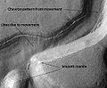
Lineated Floor Deposits
On the floors of some channels are features called lineated floor deposits. They are ridged and grooved materials that seem to deflect around obstacles. They are believed to be ice-rich. Some glaciers on the Earth show such features. Lineated floor deposits may be related to lobate debris aprons, which have been proven to contain large amounts of ice. Reull Vallis, as pictured below, displays these deposits.Ice-rich mantle
Niger Vallis
Niger Vallis is a valley on Mars that appears to have been carved by water. It has been identified as an outflow channel. It merges with Dao Vallis which runs southwestward into Hellas Planitia from the volcanic Hadriacus Mons. Like Dao, it was formed around the Late Noachian and Early Hesperian...
, as observed with HiRISE
HiRISE
High Resolution Imaging Science Experiment is a camera on board the Mars Reconnaissance Orbiter. The 65 kg , $40 million instrument was built under the direction of the University of Arizona's Lunar and Planetary Laboratory by Ball Aerospace & Technologies Corp....
.
Changes in Mars's orbit and tilt cause significant changes in the distribution of water ice from polar regions down to latitudes equivalent to Texas. During certain climate periods water vapor leaves polar ice and enters the atmosphere. The water returns to the ground at lower latitudes as deposits of frost or snow mixed generously with dust. The atmosphere of Mars contains a great deal of fine dust particles. Water vapor condenses on the particles, then they fall down to the ground due to the additional weight of the water coating. When ice at the top of the mantling layer goes back into the atmosphere, it leaves behind dust, which insulates the remaining ice.
Origin of Dao Vallis
Magma
Magma is a mixture of molten rock, volatiles and solids that is found beneath the surface of the Earth, and is expected to exist on other terrestrial planets. Besides molten rock, magma may also contain suspended crystals and dissolved gas and sometimes also gas bubbles. Magma often collects in...
melted huge amounts of ice in the frozen ground. The partially circular depressions on the left side of the channel in the image to the right suggests that groundwater sapping also contributed water.
Dust devil tracks
Dust Devils
Dust Devils is an independently published role-playing game set in the Old West, written by Matt Snyder. It was voted the 2002 Indie RPG of the Year; it also won the Best Synergy of Game and Rules category, as well as placing in the Best Production and Most Innovative Game categories.The game uses...
. A thin coating of fine bright dust covers most of the martian surface. When a dust devil goes by it blows away the coating and exposes the underlying dark surface. Dust devils have been seen from the ground and from orbiting spacecraft. They have even blown the dust off of the solar panels of the two Rover
Mars Exploration Rover
NASA's Mars Exploration Rover Mission is an ongoing robotic space mission involving two rovers, Spirit and Opportunity, exploring the planet Mars...
s on Mars, thereby greatly extending their lives. The twin Rovers were designed to last for 3 months, instead they have lasted more than five years and are still going. The pattern of the tracks have been shown to change every few months.
Evidence for possible recent liquid water
Mars Reconnaissance Orbiter
Mars Reconnaissance Orbiter is a NASA multipurpose spacecraft designed to conduct reconnaissance and Exploration of Mars from orbit...
discovered changes on the wall of Penticton Crater
Penticton Crater
Penticton Crater is an impact crater in the Hellas quadrangle of Mars, located at 38.35° south latitude and 263.35° west longitude. It is 8 km in diameter and was named after a Town in British Columbia, Canada....
between 1999 and 2004. One interpretation of the changes was that they were caused by water flowing on the surface. A further analysis, published about a year later, revealed that the deposit could have been caused by gravity moving material down slope. The slope where the deposit was sighted was close to the stability limits of dry, unconsolidated materials.
Other Craters
Impact craters generally have a rim with ejecta around them, in contrast volcanic craters usually do not have a rim or ejecta deposits. As craters get larger (greater than 10 Km in diameter) they usually have a central peak. The peak is caused by a rebound of the crater floor following the impact. Sometimes craters will display layers. Craters can show us what lies deep under the surface.See also
- Climate of MarsClimate of MarsThe climate of Mars has been an issue of scientific curiosity for centuries, not least because Mars is the only terrestrial planet whose surface can be directly observed in detail from the Earth....
- Water on MarsWater on MarsWater on Mars is a psychedelic rock and electronic music group from Quebec City, Québec, Canada. The music trio is led by Philippe Navarro, guitarist, vocalist, arranger, producer, principal lyricist, and music composer....
- Lobate Debris ApronLobate Debris ApronLobate debris aprons are geological features on Mars, first seen by the Viking Orbiters, consisting of piles of rock debris below cliffs. These features have a convex topography and a gentle slope from cliffs or escarpments, which suggest flow away from the steep source cliff...
- Geology of MarsGeology of MarsThe geology of Mars is the scientific study of the surface, crust, and interior of the planet Mars. It emphasizes the composition, structure, history, and physical processes that shape the planet. It is fully analogous to the field of terrestrial geology. In planetary science, the term geology is...
- Impact craterImpact craterIn the broadest sense, the term impact crater can be applied to any depression, natural or manmade, resulting from the high velocity impact of a projectile with a larger body...
- Pedestal craterPedestal craterIn planetary geology,a pedestal crater is a crater with its ejecta sitting above the surrounding terrain and thereby forming a raised platform. They form when an impact crater ejects material which forms an erosion-resistant layer, thus causing the immediate area to erode more slowly than the rest...
- Scalloped topographyScalloped topographyScalloped topography is common in the mid-latitudes of Mars, between 45° and 60° north and south. It is particularly prominent in the region of Utopia Planitia, , in the northern hemisphere, and in the region of Peneus and Amphitrites Patera in the southern hemisphere...
- VallisVallisVallis is the Latin word for valley. It is used in planetary geology for the naming of landform features on other planets....
- GlacierGlacierA glacier is a large persistent body of ice that forms where the accumulation of snow exceeds its ablation over many years, often centuries. At least 0.1 km² in area and 50 m thick, but often much larger, a glacier slowly deforms and flows due to stresses induced by its weight...