

Mars Reconnaissance Orbiter
Encyclopedia
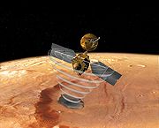
Mars Reconnaissance Orbiter (MRO) is a NASA
multipurpose spacecraft
designed to conduct reconnaissance and Exploration of Mars
from orbit. As MRO entered orbit it joined five other active spacecraft in orbit of or on the planet: Mars Global Surveyor
, Mars Express, Mars Odyssey, and two Mars Exploration Rover
s; a then record for most spacecraft operational in Mars vicinity. The spacecraft was built by Lockheed Martin
under the supervision of the Jet Propulsion Laboratory
. It was launched August 12, 2005, and attained Martian orbit on March 10, 2006. In November 2006, after five months of aerobraking
, it entered its final science orbit and began its primary science phase.
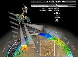
MRO contains a host of scientific instruments such as cameras, spectrometer
s, and radar
, which are used to analyze the landform
s, stratigraphy
, minerals, and ice of Mars. It paves the way for future spacecraft by monitoring daily weather and surface conditions, studying potential landing sites, and hosting a new telecommunications system. MRO's telecommunications system will transfer more data
back to Earth than all previous interplanetary missions combined, and MRO will serve as a highly capable relay satellite for future missions.
The mission is managed by the Jet Propulsion Laboratory
, at California Institute of Technology
, La Canada Flintridge, California
, for the NASA
Science Mission Directorate
, Washington, D.C.
; however, during the proposal process the orbiter lost against what became known as the Mars Exploration Rovers. The orbiter mission was rescheduled for launch in 2005, and NASA
announced its final name, Mars Reconnaissance Orbiter, on October 26, 2000.
MRO is modeled after NASA's highly successful Mars Global Surveyor
to conduct surveillance of Mars from orbit. Early specifications of the satellite included a large camera to take high resolution pictures of Mars. In this regard, Jim Garvin, the Mars exploration program scientist for NASA, proclaimed that MRO would be a "microscope in orbit". The satellite was also to include a visible-near-infrared spectrograph.
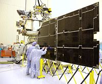
On October 3, 2001, NASA chose Lockheed Martin
as the primary contractor for the spacecraft's fabrication. By the end of 2001 all of the mission's instruments were selected. There were no major setbacks during MRO's construction, and the spacecraft was moved to John F. Kennedy Space Center on May 1, 2005 to prepare it for launch.
 MRO science operations were initially scheduled to last two Earth years, from November 2006 to November 2008. One of the mission's main goals is to map the Martian landscape with its high-resolution cameras in order to choose landing sites for future surface missions. The MRO played an important role in choosing the landing site of the Phoenix Lander
, which explored the Martian Arctic in Green Valley
. The initial site chosen by scientists was imaged with the HiRISE camera and found to be littered with boulders. After analysis with HiRISE and the Mars Odyssey's THEMIS a new site was chosen. Mars Science Laboratory
, a highly maneuverable rover, will also have its landing site inspected. The MRO will also provide critical navigation data during their landings and act as a telecommunications relay.
MRO is using its onboard scientific equipment to study the Martian climate
, weather, atmosphere, and geology, and to search for signs of liquid water in the polar caps and underground. In addition, MRO is looking for the remains of the previously lost Mars Polar Lander
and Beagle 2
spacecraft, and serves as the first step in setting up an Internet protocol
network for the planets in our solar system. After its main science operations are completed, the probe's extended mission is to be the communication and navigation system for landers and rover probes.
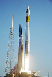 On August 12, 2005, MRO was launched aboard an Atlas V-401
rocket from Space Launch Complex 41 at Cape Canaveral Air Force Station
. The Centaur upper stage
of the rocket completed its burns over a fifty-six minute period and placed MRO in interplanetary transfer orbit
towards Mars.
MRO cruised through interplanetary space for seven and a half months before reaching Mars. While en route most of the scientific instruments and experiments were tested and calibrated. To ensure proper orbital insertion upon reaching Mars, four trajectory
correction maneuvers were planned and a fifth emergency maneuver was discussed. However, only three trajectory correction maneuvers were necessary, saving fuel for MRO's extended mission.
MRO began orbital insertion by approaching Mars on March 10, 2006, and passing above its southern hemisphere at an altitude of 370–400 km (190 mi). All six of MRO's main engines burned for 27 minutes to slow the probe from ~2,900 m/s to ~1,900 m/s (6,500 mph to 4,250 mph). The helium pressurization tank was colder than expected, which reduced the pressure in the fuel tank by about 21 kPa
(3 psi). The reduced pressure caused the engine thrust to be diminished by 2%, but MRO automatically compensated by extending the burn time by 33 seconds.
 Completion of the orbital insertion placed the orbiter in a highly elliptical
polar orbit with a period of approximately 35.5 hours. Shortly after insertion, the periapsis – the point in the orbit closest to Mars – was 3,806 km from the planet's center (426 km from its surface). The apoapsis – the point in the orbit farthest from Mars – was 47,972 km from the planet's center (44,500 km from its surface).
On March 30, 2006, MRO began the process of aerobraking
, a three-step procedure that cuts in half the fuel needed to achieve a lower, more circular orbit with a shorter period. First, during its first five orbits of the planet (one Earth week), MRO used its thrusters to drop the periapsis of its orbit into aerobraking altitude. This altitude depends on the thickness of the atmosphere
because Martian atmospheric density changes with its seasons. Second, while using its thrusters to make minor corrections to its periapsis altitude, MRO maintained aerobraking altitude for 445 planetary orbits (about 5 Earth months) to reduce the apoapsis of the orbit to 450 km (280 mi). This was done in such a way so as to not heat the spacecraft too much, but also dip enough into the atmosphere to slow the spacecraft down. After the process was complete, MRO used its thrusters to move its periapsis out of the edge of the Martian atmosphere on August 30, 2006.
In September 2006 MRO fired its thrusters twice more to fine-tune its final, nearly circular orbit to approximately 250 to 316 km (155 to 196 mi) above the Martian surface. The SHARAD dipole antennas were deployed on September 16. All of the scientific instruments were tested and most were turned off prior to the solar conjunction
which occurred from October 7 to November 6, 2006. After the conjunction ended the "primary science phase" began.
On November 17, 2006 NASA announced the successful test of the MRO as an orbital communications relay. Using the NASA rover "Spirit
" as the point of origin for the transmission, the MRO acted as a relay for transmitting data back to Earth.
 On September 29, 2006, MRO took its first high resolution image from its science orbit. This image is said to resolve items as small as 90 cm (3 feet) in diameter. On October 6, NASA
released detailed pictures from the MRO of Victoria crater along with the Opportunity rover
on the rim above it. In November, problems began to surface in the operation of two MRO spacecraft instruments. A stepping mechanism in the Mars Climate Sounder
(MCS) skipped on multiple occasions resulting in a field of view that is slightly out of position. By December normal operations of the instrument was suspended, although a mitigation strategy allows the instrument to continue making most of its intended observations. Also, an increase in noise and resulting bad pixels has been observed in several CCD
s of the High Resolution Imaging Science Experiment (HiRISE). Operation of this camera with a longer warm-up time has alleviated the issue. However, the cause is still unknown and may return.
HiRISE continues to return images which have enabled discoveries regarding the geology of Mars. Foremost among these is the announcement of banded terrain observations indicating the presence and action of liquid carbon dioxide or water on the surface of Mars in its recent geological past. HiRISE was able to photograph the Phoenix lander
during its parachuted descent to Vastitas Borealis
on May 25, 2008.
The orbiter continued to experience recurring problems in 2009, including four spontaneous resets, culminating in a four-month shut-down of the space craft from August to December. While engineers have not determined the cause of the recurrent resets, they have created new software to help troubleshoot the problem should it recur.
 The High Resolution Imaging Science Experiment camera is a 0.5 m reflecting telescope
, the largest ever carried on a deep space
mission, and has a resolution
of 1 microradian (μrad), or 0.3 m from an altitude of 300 km. In comparison, satellite images of Earth
are generally available with a resolution of 0.5 m, and satellite images on Google Maps
are available to 1 m. HiRISE collects images in three color bands, 400 to 600 nm (blue-green or B-G), 550 to 850 nm (red) and 800 to 1,000 nm (near infrared or NIR).
 Red color images are 20,264 pixel
s across (6 km wide), and B-G and NIR are 4,048 pixels across (1.2 km wide). HiRISE's onboard computer reads these lines in time with the orbiter's ground speed
, and images are potentially unlimited in length. Practically however, their length is limited by the computer's 28 Gigabit
(Gb) memory capacity, and the nominal maximum size is 20,000 × 40,000 pixels (800 megapixels) and 4,000 × 40,000 pixels (160 megapixels) for B-G and NIR images. Each 16.4 Gb image is compressed to 5 Gb before transmission and release to the general public on the HiRISE website in JPEG 2000
format. To facilitate the mapping of potential landing sites, HiRISE can produce stereo pairs
of images from which topography can be calculated to an accuracy of 0.25 m.
HiRISE was built by Ball Aerospace & Technologies Corp.
images (500 to 800 nm) with a pixel
resolution up to about 6 m. CTX is designed to provide context maps for the targeted observations of HiRISE and CRISM, and is also used to mosaic large areas of Mars, monitor a number of locations for changes over time, and to acquire stereo (3D) coverage of key regions and potential future landing sites. The optics of CTX consist of a 350 mm focal length
Maksutov Cassegrain
telescope with a 5,064 pixel wide line array CCD
. The instrument takes pictures 30 km (19 mi) wide and has enough internal memory to store an image 160 km long before loading it into the main computer. The camera was built, and is operated by Malin Space Science Systems
. CTX mapped 50% of Mars by February 2010.
 The Mars Color Imager (MARCI) is a wide-angle, low-resolution camera that views the surface of Mars in five visible and two ultraviolet
bands. Each day, MARCI collects about 84 images and produces a global map with pixel resolutions of 1 to 10 km. This map provides a daily weather report for Mars, helps to characterize its seasonal and annual variations, and maps the presence of water vapor and ozone in its atmosphere. The camera was built and is operated by Malin Space Science Systems
.
 The Compact Reconnaissance Imaging Spectrometer for Mars (CRISM) instrument is a visible
and near infrared (VNIR
) spectrometer
that is used to produce detailed maps of the surface mineralogy
of Mars. It operates from 370 to 3920 nm, measures the spectrum in 544 channels
(each 6.55 nm wide), and has a resolution
of 18 m (59.1 ft) at an altitude of 300 km (186.4 mi). CRISM is being used to identify minerals and chemicals indicative of the past or present existence of water on the surface of Mars. These materials include iron, oxides, phyllosilicates, and carbonates, which have characteristic patterns in their visible-infrared energy.
(MCS) is a spectrometer with one visible/near infrared channel (0.3 to 3.0 μm) and eight far infrared (12 to 50 μm) channels. These channels were selected to measure temperature, pressure, water vapor and dust levels. MCS observes the atmosphere on the horizon of Mars (as viewed from MRO) by breaking it up into vertical slices and taking measurements within each slice in 5 km (3 mi) increments. These measurements are assembled into daily global weather maps to show the basic variables of Martian weather: temperature, pressure, humidity and dust density.
MRO's Shallow Subsurface Radar (SHARAD) experiment is designed to probe the internal structure of the Martian polar ice cap
s. It also gathers planet-wide information about underground layers of ice
, rock
and possibly liquid water that might be accessible from the surface. SHARAD uses HF
radio waves between 15 and 25 MHz, a range that allows it to resolve layers as thin as 7 m (23 ft) to a maximum depth of 1 km (0.621372736649807 mi). It has a horizontal resolution of 0.3 to 3 km (0.186411820994942 to 1.9 ). SHARAD is designed to operate in conjunction with the Mars Express
MARSIS
, which has lower resolution but penetrates to a much greater depth. Both SHARAD and MARSIS were made by the Italian Space Agency
.
The Electra
is a UHF
software defined radio designed to communicate with other spacecraft as they approach, land, and operate on Mars. In addition to protocol controlled inter-spacecraft data links of 1 kbit/s to 2 Mbit/s, Electra also provides Doppler data collection, open loop recording and a highly accurate timing service based on a 5e-13 USO. Doppler information for approaching vehicles can be used for final descent targeting or descent and landing trajectory recreation. Doppler information on landed vehicles will also enable scientists to accurately determine the surface location of Mars landers and rovers. The two MER
spacecraft currently on Mars utilize an earlier generation UHF relay radio providing similar functions through the Mars Odyssey orbiter. The Electra radio has used the MER spacecraft to prove its functionality but it is not scheduled to provide formal relay services until the 2008 arrival of the Phoenix Mars lander
. Because the Electra radio is software defined down to the modem level, new modulation, coding or protocol functions can be added or updated while the MRO spacecraft is in orbit around Mars.
The Optical Navigation Camera images the Martian moons, Phobos
and Deimos
, against background stars to precisely determine MRO's orbit. Although moon imaging is not mission critical, it was included as a technology test for future orbiting and landing of spacecraft. The Optical Navigation Camera was tested successfully in February and March 2006.
in Denver assembled the spacecraft structure and attached the instruments. Instruments were constructed at the Jet Propulsion Laboratory, the University of Arizona
Lunar and Planetary Laboratory
in Tucson, Arizona
, Johns Hopkins University
Applied Physics Laboratory
in Laurel, Maryland
, the Italian Space Agency
in Rome, and Malin Space Science Systems
in San Diego. The total cost of the spacecraft was $720 million USD.
The structure is made of mostly carbon composites and aluminum-honeycombed plates. The titanium
fuel tank takes up most of the volume and mass of the spacecraft and provides most of its structural integrity
. The spacecraft's total mass
is less than 2,180 kg
(4,806 lb
) with an unfueled dry mass
less than 1,031 kg (2,273 lb).
 MRO gets all of its electrical power from two solar panel
s, each of which can move independently around two axes (up-down, or left-right rotation). Each solar panel measures 5.35 × 2.53 m and has 9.5 m2 (102 ft2) covered with 3,744 individual photovoltaic cells. Its high-efficiency triple junction solar cells are able to convert more than 26% of the sun's energy directly into electricity and are connected together to produce a total output of 32 volts. At Mars, the two panels produce 1,000 watt
s of power; in contrast, the panels would generate 3,000 watts in a comparable Earth orbit by being closer to the Sun.
MRO has two nickel-hydrogen rechargeable batteries used to power the spacecraft when it is not facing the sun. Each battery has an energy storage capacity of 50 ampere-hour
s (180 kC). The full range of the batteries cannot be used due to voltage constraints on the spacecraft, but allows the operators to extend the battery life—a valuable capability, given that battery drain is one of the most common causes of long-term satellite failure. Planners anticipate that only 40% of the batteries' capacities will be required during the lifetime of the spacecraft.
, 32-bit, RAD750
processor. This processor is a radiation-hardened
version of a PowerPC
750 or G3
processor with a specially built motherboard
. The RAD750 is a successor to the RAD6000
. This processor may seem underpowered in comparison to a modern PC
processor, but it is extremely reliable, resilient, and can function in solar flare
-ravaged deep space. The operating system software is VxWorks
and has extensive fault protection protocols and monitoring.
Data is stored in a 160 Gb
(20 GB) flash memory module consisting of over 700 memory chips, each with a 256 Mbit
capacity. This memory capacity is not actually that large considering the amount of data to be acquired; for example, a single image from the HiRISE camera can be as large as 28 Gb.
s used to map the position of catalogued star
s, provide NASA with full, three-axis knowledge of the spacecraft orientation and attitude. A primary and backup Miniature Inertial Measurement Unit (MIMU)
, provided by Honeywell
, measures changes to the spacecraft attitude as well as any non-gravitationally induced changes to its linear velocity. Each MIMU is a combination of three accelerometer
s and three ring-laser gyroscope
s. These systems are all critically important to MRO, as it must be able to point its camera to a very high precision in order to take the high-quality pictures that the mission requires. It has also been specifically designed to minimize any vibrations on the spacecraft, so as to allow its instruments to take images without any distortions caused by vibrations.
 The Telecom Subsystem on MRO is the best digital communication system sent into deep space so far and for the first time using capacity approaching turbo-codes. It consists of a very large (3 meter) antenna, which is used to transmit data through the Deep Space Network
via X-band frequencies at 8 GHz, and it demonstrates the use of the at 32 GHz for higher data rates. Maximum transmission speed from Mars is projected to be as high as 6 Mbit/s, a rate ten times higher than previous Mars orbiters. The spacecraft carries two 100-watt X-band amplifier
s (one of which is a backup), one 35-watt Ka-band amplifier, and two Small Deep Space Transponder
s (SDSTs).
Two smaller low-gain antennas are also present for lower-rate communication during emergencies and special events, such as launch and Mars Orbit Insertion. These antennas do not have focusing dishes and can transmit and receive from any direction. They are an important backup system to ensure that MRO can always be reached, even if its main antenna is pointed away from the Earth.
The Ka-band subsystem is used for demonstration purposes. Due to lack of spectrum at 8.41 GHz X-band, future high-rate deep space missions will use 32 GHz Ka-band. NASA Deep Space Network (DSN) has implemented Ka-band receiving capabilities at all three of its complexes (Goldstone, Canberra and Madrid) over its 34-m beam-waveguide (BWG) antenna subnet. MRO Ka-band demonstration will demonstrate viability of Ka-band for deep space operations. During the cruise phase, spacecraft Ka-band telemetry was tracked 36 times by these antennas proving DSN Ka-band reception functionality at all the antennas. During the primary science phase, Ka-band demonstration is assigned two passes a week for Ka-band demonstration purposes. The success of Ka-band during cruise also makes it a viable backup for the X-band subsystem on MRO.
 The spacecraft uses a 1,175 L
(310 US gal
) fuel tank filled with 1187 kg (2617 lb) of hydrazine
monopropellant
. Fuel pressure is regulated by adding pressurized helium gas from an external tank. Seventy percent of the fuel was used for orbital insertion.
MRO has twenty rocket engine thrusters on board. Six large thrusters each produce 170 N (38 lbf
) of thrust for a total of 1,020 N (230 lbf) meant mainly for orbital insertion. These thrusters were originally designed for the Mars Surveyor 2001 Lander
. Six medium thrusters each produce 22 N (5 lbf) of thrust for trajectory correction maneuvers and attitude control during orbit insertion. Finally, eight small thrusters each produce 0.9 N (0.2 lbf) of thrust for attitude control during normal operations.
Four reaction wheels are also used for precise attitude control during activities requiring a highly stable platform, such as high-resolution imaging, in which even small motions can cause blurring of the image. Each wheel is used for one axis of motion. The fourth (skewed) wheel is a backup in case one of the other three wheels fails. Each wheel weighs 10 kg (22 lb) and can be spun as fast as 100 Hz or 6,000 rpm
.
 An article in the journal Science in September 2009, reported that some new craters on Mars have excavated relatively pure water ice. After being exposed, the ice gradually fades as it sublimates away. These new craters were found and dated by the CTX camera, and the identification of the ice was confirmed with the Compact Imaging Spectrometer (CRISM) on board the Mars Reconnaissance Orbiter (MRO). The ice was found in a total of 5 locations. Three of the locations are in the Cebrenia quadrangle
. These locations are 55.57°N 150.62°E; 43.28°N 176.9°E; and 45°N 164.5°E. Two others are in the Diacria quadrangle
: 46.7°N 176.8°E and 46.33°N 176.9°E.>
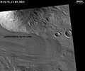 Radar results from SHARAD
suggested that features termed Lobate Debris Apron
s (LDAs) contain large amounts of water ice. Of interest from the days of the Viking
Orbiters, these LDA are aprons of material surrounding cliffs. They have a convex topography and a gentle slope; this suggests flow away from the steep source cliff. In addition, lobate debris aprons can show surface lineations just as rock glaciers on the Earth. SHARAD
has provided strong evidence that the LDAs in Hellas Planitia
are glacier
s that are covered with a thin layer of debris (i.e. rocks and dust); a strong reflection from the top and base of LDAs was observed, suggesting that pure water ice makes up the bulk of the formation (between the two reflections). Based on the experiments of the Phoenix lander and the studies of the Mars Odyssey from orbit, water ice is known to exist a just under the surface of Mars in the far north and south (high latitudes).
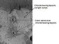 Using data from Mars Global surveyor, Mars Odyssey and the Mars Reconnaissance Orbiter, scientists have found widespread deposits of chloride minerals. Evidence suggests that the deposits were formed from the evaporation of mineral enriched waters. The research suggests that lakes may have been scattered over large areas of the Martian surface. Usually chlorides are the last minerals to come out of solution. Carbonates, sulfates, and silica should precipitate out ahead of them. Sulfates and silica have been found by the Mars Rovers on the surface. Places with chloride minerals may have once held various life forms. Furthermore, such areas could preserve traces of ancient life.
, prehnite
, and chlorite
. Rocks containing carbonate were found around the Isidis basin. Carbonates belong to one class in which life could have developed. Areas around Valles Marineris
were found to contain hydrated silica and hydrated sulfates. The researchers identified hydrated sulfates and ferric minerals in Terra Meridiani and in Valles Marineris
. Other minerals found on Mars were jarosite
, alunite
, hematite
, opal
, and gypsum
. Two to five of the mineral classes were formed with the right pH
and sufficient water to permit life to grow.
on Mars surface or subsurface.
NASA
The National Aeronautics and Space Administration is the agency of the United States government that is responsible for the nation's civilian space program and for aeronautics and aerospace research...
multipurpose spacecraft
Spacecraft
A spacecraft or spaceship is a craft or machine designed for spaceflight. Spacecraft are used for a variety of purposes, including communications, earth observation, meteorology, navigation, planetary exploration and transportation of humans and cargo....
designed to conduct reconnaissance and Exploration of Mars
Exploration of Mars
The exploration of Mars has been an important part of the space exploration programs of the Soviet Union, the United States, Europe, and Japan. Dozens of robotic spacecraft, including orbiters, landers, and rovers, have been launched toward Mars since the 1960s...
from orbit. As MRO entered orbit it joined five other active spacecraft in orbit of or on the planet: Mars Global Surveyor
Mars Global Surveyor
The Mars Global Surveyor was a US spacecraft developed by NASA's Jet Propulsion Laboratory and launched November 1996. It began the United States's return to Mars after a 10-year absence. It completed its primary mission in January 2001 and was in its third extended mission phase when, on 2...
, Mars Express, Mars Odyssey, and two Mars Exploration Rover
Mars Exploration Rover
NASA's Mars Exploration Rover Mission is an ongoing robotic space mission involving two rovers, Spirit and Opportunity, exploring the planet Mars...
s; a then record for most spacecraft operational in Mars vicinity. The spacecraft was built by Lockheed Martin
Lockheed Martin
Lockheed Martin is an American global aerospace, defense, security, and advanced technology company with worldwide interests. It was formed by the merger of Lockheed Corporation with Martin Marietta in March 1995. It is headquartered in Bethesda, Maryland, in the Washington Metropolitan Area....
under the supervision of the Jet Propulsion Laboratory
Jet Propulsion Laboratory
Jet Propulsion Laboratory is a federally funded research and development center and NASA field center located in the San Gabriel Valley area of Los Angeles County, California, United States. The facility is headquartered in the city of Pasadena on the border of La Cañada Flintridge and Pasadena...
. It was launched August 12, 2005, and attained Martian orbit on March 10, 2006. In November 2006, after five months of aerobraking
Aerobraking
Aerobraking is a spaceflight maneuver that reduces the high point of an elliptical orbit by flying the vehicle through the atmosphere at the low point of the orbit . The resulting drag slows the spacecraft...
, it entered its final science orbit and began its primary science phase.
MRO contains a host of scientific instruments such as cameras, spectrometer
Spectrometer
A spectrometer is an instrument used to measure properties of light over a specific portion of the electromagnetic spectrum, typically used in spectroscopic analysis to identify materials. The variable measured is most often the light's intensity but could also, for instance, be the polarization...
s, and radar
Radar
Radar is an object-detection system which uses radio waves to determine the range, altitude, direction, or speed of objects. It can be used to detect aircraft, ships, spacecraft, guided missiles, motor vehicles, weather formations, and terrain. The radar dish or antenna transmits pulses of radio...
, which are used to analyze the landform
Landform
A landform or physical feature in the earth sciences and geology sub-fields, comprises a geomorphological unit, and is largely defined by its surface form and location in the landscape, as part of the terrain, and as such, is typically an element of topography...
s, stratigraphy
Stratigraphy
Stratigraphy, a branch of geology, studies rock layers and layering . It is primarily used in the study of sedimentary and layered volcanic rocks....
, minerals, and ice of Mars. It paves the way for future spacecraft by monitoring daily weather and surface conditions, studying potential landing sites, and hosting a new telecommunications system. MRO's telecommunications system will transfer more data
Data transmission
Data transmission, digital transmission, or digital communications is the physical transfer of data over a point-to-point or point-to-multipoint communication channel. Examples of such channels are copper wires, optical fibres, wireless communication channels, and storage media...
back to Earth than all previous interplanetary missions combined, and MRO will serve as a highly capable relay satellite for future missions.
The mission is managed by the Jet Propulsion Laboratory
Jet Propulsion Laboratory
Jet Propulsion Laboratory is a federally funded research and development center and NASA field center located in the San Gabriel Valley area of Los Angeles County, California, United States. The facility is headquartered in the city of Pasadena on the border of La Cañada Flintridge and Pasadena...
, at California Institute of Technology
California Institute of Technology
The California Institute of Technology is a private research university located in Pasadena, California, United States. Caltech has six academic divisions with strong emphases on science and engineering...
, La Canada Flintridge, California
La Cañada Flintridge, California
La Cañada Flintridge is a small and affluent city in Los Angeles County, California, United States whose population at the 2010 census was 20,246, down from 20,318 at the 2000 census. According to Forbes, as of 2010, La Cañada Flintridge ranks as the 143rd most expensive U.S...
, for the NASA
NASA
The National Aeronautics and Space Administration is the agency of the United States government that is responsible for the nation's civilian space program and for aeronautics and aerospace research...
Science Mission Directorate
Science Mission Directorate
The Science Mission Directorate of the National Aeronautics and Space Administration engages the United States’ science community, sponsors scientific research, and develops and deploys satellites and probes in collaboration with NASA’s partners around the world to answer fundamental questions...
, Washington, D.C.
Pre-launch
MRO was one of two missions being considered for the 2003 Mars launch windowLaunch window
Launch window is a term used in spaceflight to describe a time period in which a particular launch vehicle must be launched. If the rocket does not launch within the "window", it has to wait for the next window....
; however, during the proposal process the orbiter lost against what became known as the Mars Exploration Rovers. The orbiter mission was rescheduled for launch in 2005, and NASA
NASA
The National Aeronautics and Space Administration is the agency of the United States government that is responsible for the nation's civilian space program and for aeronautics and aerospace research...
announced its final name, Mars Reconnaissance Orbiter, on October 26, 2000.
MRO is modeled after NASA's highly successful Mars Global Surveyor
Mars Global Surveyor
The Mars Global Surveyor was a US spacecraft developed by NASA's Jet Propulsion Laboratory and launched November 1996. It began the United States's return to Mars after a 10-year absence. It completed its primary mission in January 2001 and was in its third extended mission phase when, on 2...
to conduct surveillance of Mars from orbit. Early specifications of the satellite included a large camera to take high resolution pictures of Mars. In this regard, Jim Garvin, the Mars exploration program scientist for NASA, proclaimed that MRO would be a "microscope in orbit". The satellite was also to include a visible-near-infrared spectrograph.
On October 3, 2001, NASA chose Lockheed Martin
Lockheed Martin
Lockheed Martin is an American global aerospace, defense, security, and advanced technology company with worldwide interests. It was formed by the merger of Lockheed Corporation with Martin Marietta in March 1995. It is headquartered in Bethesda, Maryland, in the Washington Metropolitan Area....
as the primary contractor for the spacecraft's fabrication. By the end of 2001 all of the mission's instruments were selected. There were no major setbacks during MRO's construction, and the spacecraft was moved to John F. Kennedy Space Center on May 1, 2005 to prepare it for launch.
Mission objectives
Phoenix (spacecraft)
Phoenix was a robotic spacecraft on a space exploration mission on Mars under the Mars Scout Program. The Phoenix lander descended on Mars on May 25, 2008...
, which explored the Martian Arctic in Green Valley
Green Valley (Mars)
Green Valley is a region on Mars within Vastitas Borealis that was chosen as the landing site of NASA's Phoenix lander. It is located at 68.35 degrees north, 233 degrees east. The valley is about 50 kilometres wide but only about 250 metres deep; either it was filled in or was never any deeper than...
. The initial site chosen by scientists was imaged with the HiRISE camera and found to be littered with boulders. After analysis with HiRISE and the Mars Odyssey's THEMIS a new site was chosen. Mars Science Laboratory
Mars Science Laboratory
The Mars Science Laboratory is a National Aeronautics and Space Administration mission with the aim to land and operate a rover named Curiosity on the surface of Mars. The MSL was launched November 26, 2011, at 10:02 EST and is scheduled to land on Mars at Gale Crater between August 6 and 20, 2012...
, a highly maneuverable rover, will also have its landing site inspected. The MRO will also provide critical navigation data during their landings and act as a telecommunications relay.
MRO is using its onboard scientific equipment to study the Martian climate
Climate of Mars
The climate of Mars has been an issue of scientific curiosity for centuries, not least because Mars is the only terrestrial planet whose surface can be directly observed in detail from the Earth....
, weather, atmosphere, and geology, and to search for signs of liquid water in the polar caps and underground. In addition, MRO is looking for the remains of the previously lost Mars Polar Lander
Mars Polar Lander
The Mars Polar Lander, also referred to as the Mars Surveyor '98 Lander, was a 290-kilogram robotic spacecraft lander, launched by NASA on January 3, 1999, to study the soil and climate of Planum Australe, a region near the south pole on Mars, as part of the Mars Surveyor '98 mission...
and Beagle 2
Beagle 2
Beagle 2 was an unsuccessful British landing spacecraft that formed part of the European Space Agency's 2003 Mars Express mission. All contact with it was lost upon its separation from the Mars Express six days before its scheduled entry into the atmosphere...
spacecraft, and serves as the first step in setting up an Internet protocol
Internet Protocol
The Internet Protocol is the principal communications protocol used for relaying datagrams across an internetwork using the Internet Protocol Suite...
network for the planets in our solar system. After its main science operations are completed, the probe's extended mission is to be the communication and navigation system for landers and rover probes.
Launch and orbital insertion
Atlas V
Atlas V is an active expendable launch system in the Atlas rocket family. Atlas V was formerly operated by Lockheed Martin, and is now operated by the Lockheed Martin-Boeing joint venture United Launch Alliance...
rocket from Space Launch Complex 41 at Cape Canaveral Air Force Station
Cape Canaveral Air Force Station
Cape Canaveral Air Force Station is an installation of the United States Air Force Space Command's 45th Space Wing, headquartered at nearby Patrick Air Force Base. Located on Cape Canaveral in the state of Florida, CCAFS is the primary launch head of America's Eastern Range with four launch pads...
. The Centaur upper stage
Centaur (rocket stage)
Centaur is a rocket stage designed for use as the upper stage of space launch vehicles. Centaur boosts its satellite payload to geosynchronous orbit or, in the case of an interplanetary space probe, to or near to escape velocity...
of the rocket completed its burns over a fifty-six minute period and placed MRO in interplanetary transfer orbit
Hohmann transfer orbit
In orbital mechanics, the Hohmann transfer orbit is an elliptical orbit used to transfer between two circular orbits, typically both in the same plane....
towards Mars.
MRO cruised through interplanetary space for seven and a half months before reaching Mars. While en route most of the scientific instruments and experiments were tested and calibrated. To ensure proper orbital insertion upon reaching Mars, four trajectory
Trajectory
A trajectory is the path that a moving object follows through space as a function of time. The object might be a projectile or a satellite, for example. It thus includes the meaning of orbit—the path of a planet, an asteroid or a comet as it travels around a central mass...
correction maneuvers were planned and a fifth emergency maneuver was discussed. However, only three trajectory correction maneuvers were necessary, saving fuel for MRO's extended mission.
MRO began orbital insertion by approaching Mars on March 10, 2006, and passing above its southern hemisphere at an altitude of 370–400 km (190 mi). All six of MRO's main engines burned for 27 minutes to slow the probe from ~2,900 m/s to ~1,900 m/s (6,500 mph to 4,250 mph). The helium pressurization tank was colder than expected, which reduced the pressure in the fuel tank by about 21 kPa
KPA
KPA may refer to:* Kenya Ports Authority* Kiln phosphoric acid, a dry process to produce phosphoric acid at high temperature in a kiln* Kilopascal , a unit of pressure* Known-plaintext attack, a method of cryptanalysis* Korean People's Army...
(3 psi). The reduced pressure caused the engine thrust to be diminished by 2%, but MRO automatically compensated by extending the burn time by 33 seconds.
Elliptic orbit
In astrodynamics or celestial mechanics an elliptic orbit is a Kepler orbit with the eccentricity less than 1; this includes the special case of a circular orbit, with eccentricity equal to zero. In a stricter sense, it is a Kepler orbit with the eccentricity greater than 0 and less than 1 . In a...
polar orbit with a period of approximately 35.5 hours. Shortly after insertion, the periapsis – the point in the orbit closest to Mars – was 3,806 km from the planet's center (426 km from its surface). The apoapsis – the point in the orbit farthest from Mars – was 47,972 km from the planet's center (44,500 km from its surface).
On March 30, 2006, MRO began the process of aerobraking
Aerobraking
Aerobraking is a spaceflight maneuver that reduces the high point of an elliptical orbit by flying the vehicle through the atmosphere at the low point of the orbit . The resulting drag slows the spacecraft...
, a three-step procedure that cuts in half the fuel needed to achieve a lower, more circular orbit with a shorter period. First, during its first five orbits of the planet (one Earth week), MRO used its thrusters to drop the periapsis of its orbit into aerobraking altitude. This altitude depends on the thickness of the atmosphere
Atmosphere of Mars
The atmosphere of Mars is relatively thin and is composed mostly of carbon dioxide . There has been interest in studying its composition since the detection of trace amounts of methane, which may indicate the presence of life on Mars, but may also be produced by a geochemical process, volcanic or...
because Martian atmospheric density changes with its seasons. Second, while using its thrusters to make minor corrections to its periapsis altitude, MRO maintained aerobraking altitude for 445 planetary orbits (about 5 Earth months) to reduce the apoapsis of the orbit to 450 km (280 mi). This was done in such a way so as to not heat the spacecraft too much, but also dip enough into the atmosphere to slow the spacecraft down. After the process was complete, MRO used its thrusters to move its periapsis out of the edge of the Martian atmosphere on August 30, 2006.
In September 2006 MRO fired its thrusters twice more to fine-tune its final, nearly circular orbit to approximately 250 to 316 km (155 to 196 mi) above the Martian surface. The SHARAD dipole antennas were deployed on September 16. All of the scientific instruments were tested and most were turned off prior to the solar conjunction
Solar conjunction
Solar conjunction occurs when a planet or other solar system object is on the opposite side of the sun from the Earth. From an Earth reference, the object will pass between the sun and the Earth. Communication with any spacecraft in solar conjunction will be severely limited due to the sun's...
which occurred from October 7 to November 6, 2006. After the conjunction ended the "primary science phase" began.
On November 17, 2006 NASA announced the successful test of the MRO as an orbital communications relay. Using the NASA rover "Spirit
Spirit rover
Spirit, MER-A , is a robotic rover on Mars, active from 2004 to 2010. It was one of two rovers of NASA's ongoing Mars Exploration Rover Mission. It landed successfully on Mars at 04:35 Ground UTC on January 4, 2004, three weeks before its twin, Opportunity , landed on the other side of the planet...
" as the point of origin for the transmission, the MRO acted as a relay for transmitting data back to Earth.
Events and discoveries
NASA
The National Aeronautics and Space Administration is the agency of the United States government that is responsible for the nation's civilian space program and for aeronautics and aerospace research...
released detailed pictures from the MRO of Victoria crater along with the Opportunity rover
Opportunity rover
Opportunity, MER-B , is a robotic rover on the planet Mars, active since 2004. It is the remaining rover in NASA's ongoing Mars Exploration Rover Mission...
on the rim above it. In November, problems began to surface in the operation of two MRO spacecraft instruments. A stepping mechanism in the Mars Climate Sounder
Mars climate sounder
The Mars climate sounder is a major instrument on the Mars Reconnaissance Orbiter. The Mars Climate Sounder will look both down and horizontally through the atmosphere in order to quantify the global atmosphere’s vertical variations of water vapor, dust and temperature...
(MCS) skipped on multiple occasions resulting in a field of view that is slightly out of position. By December normal operations of the instrument was suspended, although a mitigation strategy allows the instrument to continue making most of its intended observations. Also, an increase in noise and resulting bad pixels has been observed in several CCD
Charge-coupled device
A charge-coupled device is a device for the movement of electrical charge, usually from within the device to an area where the charge can be manipulated, for example conversion into a digital value. This is achieved by "shifting" the signals between stages within the device one at a time...
s of the High Resolution Imaging Science Experiment (HiRISE). Operation of this camera with a longer warm-up time has alleviated the issue. However, the cause is still unknown and may return.
HiRISE continues to return images which have enabled discoveries regarding the geology of Mars. Foremost among these is the announcement of banded terrain observations indicating the presence and action of liquid carbon dioxide or water on the surface of Mars in its recent geological past. HiRISE was able to photograph the Phoenix lander
Phoenix (spacecraft)
Phoenix was a robotic spacecraft on a space exploration mission on Mars under the Mars Scout Program. The Phoenix lander descended on Mars on May 25, 2008...
during its parachuted descent to Vastitas Borealis
Vastitas Borealis
Vastitas Borealis is the largest lowland region of Mars. It is in the northerly latitudes of the planet and encircles the northern polar region. Vastitas Borealis is often simply referred to as the Northern plains or Northern lowlands of Mars. The plains lie 4–5 km below the mean radius of...
on May 25, 2008.
The orbiter continued to experience recurring problems in 2009, including four spontaneous resets, culminating in a four-month shut-down of the space craft from August to December. While engineers have not determined the cause of the recurrent resets, they have created new software to help troubleshoot the problem should it recur.
Instruments
Three cameras, two spectrometers and a radar are included on the orbiter along with two "science-facility instruments", which use data from engineering subsystems to collect science data. Three technology experiments will test and demonstrate new equipment for future missions. It is expected MRO will obtain about 5,000 images a year.HiRISE (camera)
Reflecting telescope
A reflecting telescope is an optical telescope which uses a single or combination of curved mirrors that reflect light and form an image. The reflecting telescope was invented in the 17th century as an alternative to the refracting telescope which, at that time, was a design that suffered from...
, the largest ever carried on a deep space
Outer space
Outer space is the void that exists between celestial bodies, including the Earth. It is not completely empty, but consists of a hard vacuum containing a low density of particles: predominantly a plasma of hydrogen and helium, as well as electromagnetic radiation, magnetic fields, and neutrinos....
mission, and has a resolution
Angular resolution
Angular resolution, or spatial resolution, describes the ability of any image-forming device such as an optical or radio telescope, a microscope, a camera, or an eye, to distinguish small details of an object...
of 1 microradian (μrad), or 0.3 m from an altitude of 300 km. In comparison, satellite images of Earth
Satellite imagery
Satellite imagery consists of photographs of Earth or other planets made by means of artificial satellites.- History :The first images from space were taken on sub-orbital flights. The U.S-launched V-2 flight on October 24, 1946 took one image every 1.5 seconds...
are generally available with a resolution of 0.5 m, and satellite images on Google Maps
Google Maps
Google Maps is a web mapping service application and technology provided by Google, free , that powers many map-based services, including the Google Maps website, Google Ride Finder, Google Transit, and maps embedded on third-party websites via the Google Maps API...
are available to 1 m. HiRISE collects images in three color bands, 400 to 600 nm (blue-green or B-G), 550 to 850 nm (red) and 800 to 1,000 nm (near infrared or NIR).
Pixel
In digital imaging, a pixel, or pel, is a single point in a raster image, or the smallest addressable screen element in a display device; it is the smallest unit of picture that can be represented or controlled....
s across (6 km wide), and B-G and NIR are 4,048 pixels across (1.2 km wide). HiRISE's onboard computer reads these lines in time with the orbiter's ground speed
Ground speed
Ground speed is the speed of an aircraft relative to the ground. Information displayed to passengers through the entertainment system often gives the aircraft groundspeed rather than airspeed....
, and images are potentially unlimited in length. Practically however, their length is limited by the computer's 28 Gigabit
Gigabit
The gigabit is a multiple of the unit bit for digital information or computer storage. The prefix giga is defined in the International System of Units as a multiplier of 109 , and therefore...
(Gb) memory capacity, and the nominal maximum size is 20,000 × 40,000 pixels (800 megapixels) and 4,000 × 40,000 pixels (160 megapixels) for B-G and NIR images. Each 16.4 Gb image is compressed to 5 Gb before transmission and release to the general public on the HiRISE website in JPEG 2000
JPEG 2000
JPEG 2000 is an image compression standard and coding system. It was created by the Joint Photographic Experts Group committee in 2000 with the intention of superseding their original discrete cosine transform-based JPEG standard with a newly designed, wavelet-based method...
format. To facilitate the mapping of potential landing sites, HiRISE can produce stereo pairs
Photogrammetry
Photogrammetry is the practice of determining the geometric properties of objects from photographic images. Photogrammetry is as old as modern photography and can be dated to the mid-nineteenth century....
of images from which topography can be calculated to an accuracy of 0.25 m.
HiRISE was built by Ball Aerospace & Technologies Corp.
CTX (camera)
The Context Camera (CTX) provides grayscaleGrayscale
In photography and computing, a grayscale or greyscale digital image is an image in which the value of each pixel is a single sample, that is, it carries only intensity information...
images (500 to 800 nm) with a pixel
Pixel
In digital imaging, a pixel, or pel, is a single point in a raster image, or the smallest addressable screen element in a display device; it is the smallest unit of picture that can be represented or controlled....
resolution up to about 6 m. CTX is designed to provide context maps for the targeted observations of HiRISE and CRISM, and is also used to mosaic large areas of Mars, monitor a number of locations for changes over time, and to acquire stereo (3D) coverage of key regions and potential future landing sites. The optics of CTX consist of a 350 mm focal length
Focal length
The focal length of an optical system is a measure of how strongly the system converges or diverges light. For an optical system in air, it is the distance over which initially collimated rays are brought to a focus...
Maksutov Cassegrain
Cassegrain reflector
The Cassegrain reflector is a combination of a primary concave mirror and a secondary convex mirror, often used in optical telescopes and radio antennas....
telescope with a 5,064 pixel wide line array CCD
Charge-coupled device
A charge-coupled device is a device for the movement of electrical charge, usually from within the device to an area where the charge can be manipulated, for example conversion into a digital value. This is achieved by "shifting" the signals between stages within the device one at a time...
. The instrument takes pictures 30 km (19 mi) wide and has enough internal memory to store an image 160 km long before loading it into the main computer. The camera was built, and is operated by Malin Space Science Systems
Malin Space Science Systems
Malin Space Science Systems is a San Diego, California company that designs, develops, and operates instruments to fly on unmanned spacecraft. MSSS is headed by chief scientist and CEO Michael C. Malin....
. CTX mapped 50% of Mars by February 2010.
MARCI (camera)
Ultraviolet
Ultraviolet light is electromagnetic radiation with a wavelength shorter than that of visible light, but longer than X-rays, in the range 10 nm to 400 nm, and energies from 3 eV to 124 eV...
bands. Each day, MARCI collects about 84 images and produces a global map with pixel resolutions of 1 to 10 km. This map provides a daily weather report for Mars, helps to characterize its seasonal and annual variations, and maps the presence of water vapor and ozone in its atmosphere. The camera was built and is operated by Malin Space Science Systems
Malin Space Science Systems
Malin Space Science Systems is a San Diego, California company that designs, develops, and operates instruments to fly on unmanned spacecraft. MSSS is headed by chief scientist and CEO Michael C. Malin....
.
CRISM (spectrometer)
Visible spectrum
The visible spectrum is the portion of the electromagnetic spectrum that is visible to the human eye. Electromagnetic radiation in this range of wavelengths is called visible light or simply light. A typical human eye will respond to wavelengths from about 390 to 750 nm. In terms of...
and near infrared (VNIR
VNIR
VNIR is an initialism for visible and near-infrared, a portion of the electromagnetic spectrum having wavelengths between approximately 400 and 1400 nanometers ...
) spectrometer
Spectrometer
A spectrometer is an instrument used to measure properties of light over a specific portion of the electromagnetic spectrum, typically used in spectroscopic analysis to identify materials. The variable measured is most often the light's intensity but could also, for instance, be the polarization...
that is used to produce detailed maps of the surface mineralogy
Mineralogy
Mineralogy is the study of chemistry, crystal structure, and physical properties of minerals. Specific studies within mineralogy include the processes of mineral origin and formation, classification of minerals, their geographical distribution, as well as their utilization.-History:Early writing...
of Mars. It operates from 370 to 3920 nm, measures the spectrum in 544 channels
Channel (digital image)
Color digital images are made of pixels, and pixels are made of combinations of primary colors. A channel in this context is the grayscale image of the same size as a color image, made of just one of these primary colors. For instance, an image from a standard digital camera will have a red, green...
(each 6.55 nm wide), and has a resolution
Angular resolution
Angular resolution, or spatial resolution, describes the ability of any image-forming device such as an optical or radio telescope, a microscope, a camera, or an eye, to distinguish small details of an object...
of 18 m (59.1 ft) at an altitude of 300 km (186.4 mi). CRISM is being used to identify minerals and chemicals indicative of the past or present existence of water on the surface of Mars. These materials include iron, oxides, phyllosilicates, and carbonates, which have characteristic patterns in their visible-infrared energy.
MCS (spectrometer)
The Mars Climate SounderMars climate sounder
The Mars climate sounder is a major instrument on the Mars Reconnaissance Orbiter. The Mars Climate Sounder will look both down and horizontally through the atmosphere in order to quantify the global atmosphere’s vertical variations of water vapor, dust and temperature...
(MCS) is a spectrometer with one visible/near infrared channel (0.3 to 3.0 μm) and eight far infrared (12 to 50 μm) channels. These channels were selected to measure temperature, pressure, water vapor and dust levels. MCS observes the atmosphere on the horizon of Mars (as viewed from MRO) by breaking it up into vertical slices and taking measurements within each slice in 5 km (3 mi) increments. These measurements are assembled into daily global weather maps to show the basic variables of Martian weather: temperature, pressure, humidity and dust density.
SHARAD (radar)
MRO's Shallow Subsurface Radar (SHARAD) experiment is designed to probe the internal structure of the Martian polar ice cap
Ice cap
An ice cap is an ice mass that covers less than 50 000 km² of land area . Masses of ice covering more than 50 000 km² are termed an ice sheet....
s. It also gathers planet-wide information about underground layers of ice
Ice
Ice is water frozen into the solid state. Usually ice is the phase known as ice Ih, which is the most abundant of the varying solid phases on the Earth's surface. It can appear transparent or opaque bluish-white color, depending on the presence of impurities or air inclusions...
, rock
Rock (geology)
In geology, rock or stone is a naturally occurring solid aggregate of minerals and/or mineraloids.The Earth's outer solid layer, the lithosphere, is made of rock. In general rocks are of three types, namely, igneous, sedimentary, and metamorphic...
and possibly liquid water that might be accessible from the surface. SHARAD uses HF
High frequency
High frequency radio frequencies are between 3 and 30 MHz. Also known as the decameter band or decameter wave as the wavelengths range from one to ten decameters . Frequencies immediately below HF are denoted Medium-frequency , and the next higher frequencies are known as Very high frequency...
radio waves between 15 and 25 MHz, a range that allows it to resolve layers as thin as 7 m (23 ft) to a maximum depth of 1 km (0.621372736649807 mi). It has a horizontal resolution of 0.3 to 3 km (0.186411820994942 to 1.9 ). SHARAD is designed to operate in conjunction with the Mars Express
Mars Express
Mars Express is a space exploration mission being conducted by the European Space Agency . The Mars Express mission is exploring the planet Mars, and is the first planetary mission attempted by the agency. "Express" originally referred to the speed and efficiency with which the spacecraft was...
MARSIS
MARSIS
MARSIS is a low frequency, pulse-limited radar sounder and altimeter used on the ESA Mars Express mission...
, which has lower resolution but penetrates to a much greater depth. Both SHARAD and MARSIS were made by the Italian Space Agency
Italian Space Agency
The Italian Space Agency is a government agency established in 1988 to fund, regulate and coordinate space exploration activities in Italy...
.
Engineering instruments
In addition to its imaging equipment, MRO carries a variety of engineering instruments. The Gravity Field Investigation Package measures variations in the Martian gravitational field through variations in the spacecraft's velocity. Velocity changes are detected by measuring doppler shifts in MRO's radio signals received on Earth. The package also includes sensitive onboard accelerometers used to deduce the in situ atmospheric density of Mars during aerobraking.The Electra
Electra (radio)
Electra, more formally the Electra Proximity Payload, is a software-defined radio defined and implemented by the Jet Propulsion Laboratory for use between spacecraft. It is typically used by a lander to communicate with an orbiter that can then communicate with Earth...
is a UHF
Ultra high frequency
Ultra-High Frequency designates the ITU Radio frequency range of electromagnetic waves between 300 MHz and 3 GHz , also known as the decimetre band or decimetre wave as the wavelengths range from one to ten decimetres...
software defined radio designed to communicate with other spacecraft as they approach, land, and operate on Mars. In addition to protocol controlled inter-spacecraft data links of 1 kbit/s to 2 Mbit/s, Electra also provides Doppler data collection, open loop recording and a highly accurate timing service based on a 5e-13 USO. Doppler information for approaching vehicles can be used for final descent targeting or descent and landing trajectory recreation. Doppler information on landed vehicles will also enable scientists to accurately determine the surface location of Mars landers and rovers. The two MER
Mars Exploration Rover
NASA's Mars Exploration Rover Mission is an ongoing robotic space mission involving two rovers, Spirit and Opportunity, exploring the planet Mars...
spacecraft currently on Mars utilize an earlier generation UHF relay radio providing similar functions through the Mars Odyssey orbiter. The Electra radio has used the MER spacecraft to prove its functionality but it is not scheduled to provide formal relay services until the 2008 arrival of the Phoenix Mars lander
Phoenix (spacecraft)
Phoenix was a robotic spacecraft on a space exploration mission on Mars under the Mars Scout Program. The Phoenix lander descended on Mars on May 25, 2008...
. Because the Electra radio is software defined down to the modem level, new modulation, coding or protocol functions can be added or updated while the MRO spacecraft is in orbit around Mars.
The Optical Navigation Camera images the Martian moons, Phobos
Phobos (moon)
Phobos is the larger and closer of the two natural satellites of Mars. Both moons were discovered in 1877. With a mean radius of , Phobos is 7.24 times as massive as Deimos...
and Deimos
Deimos (moon)
Deimos is the smaller and outer of Mars's two moons . It is named after Deimos, a figure representing dread in Greek Mythology. Its systematic designation is '.-Discovery:Deimos was discovered by Asaph Hall, Sr...
, against background stars to precisely determine MRO's orbit. Although moon imaging is not mission critical, it was included as a technology test for future orbiting and landing of spacecraft. The Optical Navigation Camera was tested successfully in February and March 2006.
Structure
Workers at Lockheed Martin Space SystemsLockheed Martin Space Systems
Lockheed Martin Space Systems Company is one of the four major business divisions of Lockheed Martin. It is headquartered in Denver, Colorado with additional sites in Sunnyvale, California; Newtown, Pennsylvania; Huntsville, Alabama; and elsewhere in the US and UK...
in Denver assembled the spacecraft structure and attached the instruments. Instruments were constructed at the Jet Propulsion Laboratory, the University of Arizona
University of Arizona
The University of Arizona is a land-grant and space-grant public institution of higher education and research located in Tucson, Arizona, United States. The University of Arizona was the first university in the state of Arizona, founded in 1885...
Lunar and Planetary Laboratory
Lunar and Planetary Laboratory
The Lunar and Planetary Laboratory is a research center for planetary science located in Tucson, Arizona. It is also a graduate school, constituting the Department of Planetary Sciences at the University of Arizona...
in Tucson, Arizona
Tucson, Arizona
Tucson is a city in and the county seat of Pima County, Arizona, United States. The city is located 118 miles southeast of Phoenix and 60 miles north of the U.S.-Mexico border. The 2010 United States Census puts the city's population at 520,116 with a metropolitan area population at 1,020,200...
, Johns Hopkins University
Johns Hopkins University
The Johns Hopkins University, commonly referred to as Johns Hopkins, JHU, or simply Hopkins, is a private research university based in Baltimore, Maryland, United States...
Applied Physics Laboratory
Applied Physics Laboratory
The Johns Hopkins University Applied Physics Laboratory , located in Howard County, Maryland near Laurel and Columbia, is a not-for-profit, university-affiliated research center employing 4,500 people. APL is primarily a defense contractor. It serves as a technical resource for the Department of...
in Laurel, Maryland
Laurel, Maryland
Laurel is a city in northern Prince George's County, Anne Arundel County, and Howard County, Maryland, United States, located midway between Washington, D.C. and Baltimore. Incorporated in 1870, the city maintains a historic district including its Main Street...
, the Italian Space Agency
Italian Space Agency
The Italian Space Agency is a government agency established in 1988 to fund, regulate and coordinate space exploration activities in Italy...
in Rome, and Malin Space Science Systems
Malin Space Science Systems
Malin Space Science Systems is a San Diego, California company that designs, develops, and operates instruments to fly on unmanned spacecraft. MSSS is headed by chief scientist and CEO Michael C. Malin....
in San Diego. The total cost of the spacecraft was $720 million USD.
The structure is made of mostly carbon composites and aluminum-honeycombed plates. The titanium
Titanium
Titanium is a chemical element with the symbol Ti and atomic number 22. It has a low density and is a strong, lustrous, corrosion-resistant transition metal with a silver color....
fuel tank takes up most of the volume and mass of the spacecraft and provides most of its structural integrity
Structural engineering
Structural engineering is a field of engineering dealing with the analysis and design of structures that support or resist loads. Structural engineering is usually considered a specialty within civil engineering, but it can also be studied in its own right....
. The spacecraft's total mass
Mass
Mass can be defined as a quantitive measure of the resistance an object has to change in its velocity.In physics, mass commonly refers to any of the following three properties of matter, which have been shown experimentally to be equivalent:...
is less than 2,180 kg
Kilogram
The kilogram or kilogramme , also known as the kilo, is the base unit of mass in the International System of Units and is defined as being equal to the mass of the International Prototype Kilogram , which is almost exactly equal to the mass of one liter of water...
(4,806 lb
Pound (mass)
The pound or pound-mass is a unit of mass used in the Imperial, United States customary and other systems of measurement...
) with an unfueled dry mass
Mass ratio
In aerospace engineering, mass ratio is a measure of the efficiency of a rocket. It describes how much more massive the vehicle is with propellant than without; that is, it is the ratio of the rocket's wet mass to its dry mass...
less than 1,031 kg (2,273 lb).
Power systems
Photovoltaic module
A solar panel is a packaged, connected assembly of solar cells, also known as photovoltaic cells...
s, each of which can move independently around two axes (up-down, or left-right rotation). Each solar panel measures 5.35 × 2.53 m and has 9.5 m2 (102 ft2) covered with 3,744 individual photovoltaic cells. Its high-efficiency triple junction solar cells are able to convert more than 26% of the sun's energy directly into electricity and are connected together to produce a total output of 32 volts. At Mars, the two panels produce 1,000 watt
Watt
The watt is a derived unit of power in the International System of Units , named after the Scottish engineer James Watt . The unit, defined as one joule per second, measures the rate of energy conversion.-Definition:...
s of power; in contrast, the panels would generate 3,000 watts in a comparable Earth orbit by being closer to the Sun.
MRO has two nickel-hydrogen rechargeable batteries used to power the spacecraft when it is not facing the sun. Each battery has an energy storage capacity of 50 ampere-hour
Ampere-hour
An ampere-hour or amp-hour is a unit of electric charge, with sub-units milliampere-hour and milliampere second...
s (180 kC). The full range of the batteries cannot be used due to voltage constraints on the spacecraft, but allows the operators to extend the battery life—a valuable capability, given that battery drain is one of the most common causes of long-term satellite failure. Planners anticipate that only 40% of the batteries' capacities will be required during the lifetime of the spacecraft.
Electronic systems
MRO's main computer is a 133 MHz, 10.4 million transistorTransistor
A transistor is a semiconductor device used to amplify and switch electronic signals and power. It is composed of a semiconductor material with at least three terminals for connection to an external circuit. A voltage or current applied to one pair of the transistor's terminals changes the current...
, 32-bit, RAD750
RAD750
The RAD750 is a radiation-hardened single board computer, based on IBM's PowerPC 750. The successor of the RAD6000, the RAD750 is manufactured by BAE Systems Electronic Solutions. It is intended for use in high radiation environments such as experienced on board satellites and spacecraft...
processor. This processor is a radiation-hardened
Radiation hardening
Radiation hardening is a method of designing and testing electronic components and systems to make them resistant to damage or malfunctions caused by ionizing radiation , such as would be encountered in outer space, high-altitude flight, around nuclear reactors, particle accelerators, or during...
version of a PowerPC
PowerPC
PowerPC is a RISC architecture created by the 1991 Apple–IBM–Motorola alliance, known as AIM...
750 or G3
PowerPC G3
The PowerPC 7xx is a family of third generation 32-bit PowerPC microprocessors designed and manufactured by IBM and Motorola . This family is called the PowerPC G3 by its well-known customer Apple Computer...
processor with a specially built motherboard
Motherboard
In personal computers, a motherboard is the central printed circuit board in many modern computers and holds many of the crucial components of the system, providing connectors for other peripherals. The motherboard is sometimes alternatively known as the mainboard, system board, or, on Apple...
. The RAD750 is a successor to the RAD6000
RAD6000
The RAD6000 radiation-hardened single board computer, based on the IBM RISC Single Chip CPU, was manufactured by IBM Federal Systems. IBM Federal Systems was sold to Loral, and by way of acquisition, ended up with Lockheed Martin and is currently a part of BAE Systems...
. This processor may seem underpowered in comparison to a modern PC
Personal computer
A personal computer is any general-purpose computer whose size, capabilities, and original sales price make it useful for individuals, and which is intended to be operated directly by an end-user with no intervening computer operator...
processor, but it is extremely reliable, resilient, and can function in solar flare
Solar flare
A solar flare is a sudden brightening observed over the Sun surface or the solar limb, which is interpreted as a large energy release of up to 6 × 1025 joules of energy . The flare ejects clouds of electrons, ions, and atoms through the corona into space. These clouds typically reach Earth a day...
-ravaged deep space. The operating system software is VxWorks
VxWorks
VxWorks is a real-time operating system developed as proprietary software by Wind River Systems of Alameda, California, USA. First released in 1987, VxWorks is designed for use in embedded systems.- History :...
and has extensive fault protection protocols and monitoring.
Data is stored in a 160 Gb
Gigabit
The gigabit is a multiple of the unit bit for digital information or computer storage. The prefix giga is defined in the International System of Units as a multiplier of 109 , and therefore...
(20 GB) flash memory module consisting of over 700 memory chips, each with a 256 Mbit
Megabit
The megabit is a multiple of the unit bit for digital information or computer storage. The prefix mega is defined in the International System of Units as a multiplier of 106 , and therefore...
capacity. This memory capacity is not actually that large considering the amount of data to be acquired; for example, a single image from the HiRISE camera can be as large as 28 Gb.
Attitude determination
In order to determine the spacecraft's orbit and facilitate maneuvers, sixteen sun sensors – eight primaries and eight backups – are placed around the spacecraft to calibrate solar direction relative to the orbiter's frame. Two star trackers, digital cameraDigital camera
A digital camera is a camera that takes video or still photographs, or both, digitally by recording images via an electronic image sensor. It is the main device used in the field of digital photography...
s used to map the position of catalogued star
Star
A star is a massive, luminous sphere of plasma held together by gravity. At the end of its lifetime, a star can also contain a proportion of degenerate matter. The nearest star to Earth is the Sun, which is the source of most of the energy on Earth...
s, provide NASA with full, three-axis knowledge of the spacecraft orientation and attitude. A primary and backup Miniature Inertial Measurement Unit (MIMU)
Miniature Inertial Measurement Unit (MIMU)
Miniature inertial measurement unit is an inertial measurement unit developed and built by Honeywell International to control and stabilize spacecraft during mission operations. MIMUs can also be configured to perform as an inertial reference unit...
, provided by Honeywell
Honeywell
Honeywell International, Inc. is a major conglomerate company that produces a variety of consumer products, engineering services, and aerospace systems for a wide variety of customers, from private consumers to major corporations and governments....
, measures changes to the spacecraft attitude as well as any non-gravitationally induced changes to its linear velocity. Each MIMU is a combination of three accelerometer
Accelerometer
An accelerometer is a device that measures proper acceleration, also called the four-acceleration. This is not necessarily the same as the coordinate acceleration , but is rather the type of acceleration associated with the phenomenon of weight experienced by a test mass that resides in the frame...
s and three ring-laser gyroscope
Gyroscope
A gyroscope is a device for measuring or maintaining orientation, based on the principles of angular momentum. In essence, a mechanical gyroscope is a spinning wheel or disk whose axle is free to take any orientation...
s. These systems are all critically important to MRO, as it must be able to point its camera to a very high precision in order to take the high-quality pictures that the mission requires. It has also been specifically designed to minimize any vibrations on the spacecraft, so as to allow its instruments to take images without any distortions caused by vibrations.
Telecommunications system
Deep Space Network
The Deep Space Network, or DSN, is a world-wide network of large antennas and communication facilities that supports interplanetary spacecraft missions. It also performs radio and radar astronomy observations for the exploration of the solar system and the universe, and supports selected...
via X-band frequencies at 8 GHz, and it demonstrates the use of the at 32 GHz for higher data rates. Maximum transmission speed from Mars is projected to be as high as 6 Mbit/s, a rate ten times higher than previous Mars orbiters. The spacecraft carries two 100-watt X-band amplifier
Amplifier
Generally, an amplifier or simply amp, is a device for increasing the power of a signal.In popular use, the term usually describes an electronic amplifier, in which the input "signal" is usually a voltage or a current. In audio applications, amplifiers drive the loudspeakers used in PA systems to...
s (one of which is a backup), one 35-watt Ka-band amplifier, and two Small Deep Space Transponder
Small deep space transponder
The Small Deep Space Transponder is a transponder designed by JPL specifically for deep space probes. It unifies a number of communication functions -...
s (SDSTs).
Two smaller low-gain antennas are also present for lower-rate communication during emergencies and special events, such as launch and Mars Orbit Insertion. These antennas do not have focusing dishes and can transmit and receive from any direction. They are an important backup system to ensure that MRO can always be reached, even if its main antenna is pointed away from the Earth.
The Ka-band subsystem is used for demonstration purposes. Due to lack of spectrum at 8.41 GHz X-band, future high-rate deep space missions will use 32 GHz Ka-band. NASA Deep Space Network (DSN) has implemented Ka-band receiving capabilities at all three of its complexes (Goldstone, Canberra and Madrid) over its 34-m beam-waveguide (BWG) antenna subnet. MRO Ka-band demonstration will demonstrate viability of Ka-band for deep space operations. During the cruise phase, spacecraft Ka-band telemetry was tracked 36 times by these antennas proving DSN Ka-band reception functionality at all the antennas. During the primary science phase, Ka-band demonstration is assigned two passes a week for Ka-band demonstration purposes. The success of Ka-band during cruise also makes it a viable backup for the X-band subsystem on MRO.
Propulsion and attitude control
Litér
- External links :*...
(310 US gal
Gallon
The gallon is a measure of volume. Historically it has had many different definitions, but there are three definitions in current use: the imperial gallon which is used in the United Kingdom and semi-officially within Canada, the United States liquid gallon and the lesser used United States dry...
) fuel tank filled with 1187 kg (2617 lb) of hydrazine
Hydrazine
Hydrazine is an inorganic compound with the formula N2H4. It is a colourless flammable liquid with an ammonia-like odor. Hydrazine is highly toxic and dangerously unstable unless handled in solution. Approximately 260,000 tons are manufactured annually...
monopropellant
Monopropellant
Monopropellants are propellants composed of chemicals or mixtures of chemicals which can be stored in a single container with some degree of safety. While stable under defined storage conditions, they react very rapidly under certain other conditions to produce a large volume of energetic gases...
. Fuel pressure is regulated by adding pressurized helium gas from an external tank. Seventy percent of the fuel was used for orbital insertion.
MRO has twenty rocket engine thrusters on board. Six large thrusters each produce 170 N (38 lbf
Pound-force
The pound force is a unit of force in some systems of measurement including English engineering units and British gravitational units.- Definitions :...
) of thrust for a total of 1,020 N (230 lbf) meant mainly for orbital insertion. These thrusters were originally designed for the Mars Surveyor 2001 Lander
Mars Surveyor 2001 Lander
The NASA Mars Surveyor 2001 Lander was a planned Mars probe which was canceled in May 2000 in the wake of the failures of the Mars Climate Orbiter and Mars Polar Lander missions in late 1999...
. Six medium thrusters each produce 22 N (5 lbf) of thrust for trajectory correction maneuvers and attitude control during orbit insertion. Finally, eight small thrusters each produce 0.9 N (0.2 lbf) of thrust for attitude control during normal operations.
Four reaction wheels are also used for precise attitude control during activities requiring a highly stable platform, such as high-resolution imaging, in which even small motions can cause blurring of the image. Each wheel is used for one axis of motion. The fourth (skewed) wheel is a backup in case one of the other three wheels fails. Each wheel weighs 10 kg (22 lb) and can be spun as fast as 100 Hz or 6,000 rpm
Revolutions per minute
Revolutions per minute is a measure of the frequency of a rotation. It annotates the number of full rotations completed in one minute around a fixed axis...
.
Water ice in ice cap measured
Results published in 2009 of radar measurements of the north polar ice cap determined that the volume of water ice in the cap is 821,000 cubic kilometers (197,000 cubic miles), equal to 30% of the Earth's Greenland ice sheet.Ice exposed in new craters
Cebrenia quadrangle
The Cebrenia quadrangle is one of a series of 30 quadrangle maps of Mars used by the United States Geological Survey Astrogeology Research Program. The quadrangle is located in the northeastern portion of Mars’ eastern hemisphere and covers 120° to 180° east longitude and 30° to 65° north latitude...
. These locations are 55.57°N 150.62°E; 43.28°N 176.9°E; and 45°N 164.5°E. Two others are in the Diacria quadrangle
Diacria quadrangle
The Diacria quadrangle is one of a series of 30 quadrangle maps of Mars used by the United States Geological Survey Astrogeology Research Program. The quadrangle is located in the northwestern portion of Mars’ western hemisphere and covers 180° to 240° east longitude and 30° to 65° north latitude...
: 46.7°N 176.8°E and 46.33°N 176.9°E.>
Ice in lobate debris aprons
SHARAD
SHARAD is a subsurface sounding radar embarked on the Mars Reconnaissance Orbiter probe. It complements the MARSIS instrument on Mars Express, providing lower penetration capabilities but much finer resolution .SHARAD is developed under the responsibility of the Italian Space Agency SHARAD (Mars...
suggested that features termed Lobate Debris Apron
Lobate Debris Apron
Lobate debris aprons are geological features on Mars, first seen by the Viking Orbiters, consisting of piles of rock debris below cliffs. These features have a convex topography and a gentle slope from cliffs or escarpments, which suggest flow away from the steep source cliff...
s (LDAs) contain large amounts of water ice. Of interest from the days of the Viking
Viking
The term Viking is customarily used to refer to the Norse explorers, warriors, merchants, and pirates who raided, traded, explored and settled in wide areas of Europe, Asia and the North Atlantic islands from the late 8th to the mid-11th century.These Norsemen used their famed longships to...
Orbiters, these LDA are aprons of material surrounding cliffs. They have a convex topography and a gentle slope; this suggests flow away from the steep source cliff. In addition, lobate debris aprons can show surface lineations just as rock glaciers on the Earth. SHARAD
SHARAD
SHARAD is a subsurface sounding radar embarked on the Mars Reconnaissance Orbiter probe. It complements the MARSIS instrument on Mars Express, providing lower penetration capabilities but much finer resolution .SHARAD is developed under the responsibility of the Italian Space Agency SHARAD (Mars...
has provided strong evidence that the LDAs in Hellas Planitia
Hellas Planitia
Hellas Planitia, also known as the Hellas Impact Basin, is a huge, roughly circular impact basin located in the southern hemisphere of the planet Mars. It is the second or third largest impact crater and the largest visible impact crater known in the Solar System...
are glacier
Glacier
A glacier is a large persistent body of ice that forms where the accumulation of snow exceeds its ablation over many years, often centuries. At least 0.1 km² in area and 50 m thick, but often much larger, a glacier slowly deforms and flows due to stresses induced by its weight...
s that are covered with a thin layer of debris (i.e. rocks and dust); a strong reflection from the top and base of LDAs was observed, suggesting that pure water ice makes up the bulk of the formation (between the two reflections). Based on the experiments of the Phoenix lander and the studies of the Mars Odyssey from orbit, water ice is known to exist a just under the surface of Mars in the far north and south (high latitudes).
Chloride deposits
Other aqueous minerals
In 2009, a group of scientists from the CRISM team reported on 9 to 10 different classes of minerals formed in the presence of water. Different types of clays (also called phyllosilicates) were found in many locations. The physilicates identified included aluminum smectite, iron/magnesium smectite, kaoliniteKaolinite
Kaolinite is a clay mineral, part of the group of industrial minerals, with the chemical composition Al2Si2O54. It is a layered silicate mineral, with one tetrahedral sheet linked through oxygen atoms to one octahedral sheet of alumina octahedra...
, prehnite
Prehnite
Prehnite is a phyllosilicate of calcium and aluminium with the formula: Ca2Al2. Limited Fe3+ substitutes for aluminium in the structure. Prehnite crystallizes in the orthorhombic crystal system, and most oftens forms as stalactitic or botryoidal aggregates, with only just the crests of small...
, and chlorite
Chlorite
The chlorite ion is ClO2−. A chlorite is a compound that contains this group,with chlorine in oxidation state +3. Chlorites are also known as salts of chlorous acid.-Oxidation states:...
. Rocks containing carbonate were found around the Isidis basin. Carbonates belong to one class in which life could have developed. Areas around Valles Marineris
Valles Marineris
Valles Marineris is a system of canyons that runs along the Martian surface east of the Tharsis region...
were found to contain hydrated silica and hydrated sulfates. The researchers identified hydrated sulfates and ferric minerals in Terra Meridiani and in Valles Marineris
Valles Marineris
Valles Marineris is a system of canyons that runs along the Martian surface east of the Tharsis region...
. Other minerals found on Mars were jarosite
Jarosite
Jarosite is a basic hydrous sulfate of potassium and iron with a chemical formula of KFe3+362. This sulfate mineral is formed in ore deposits by the oxidation of iron sulfides...
, alunite
Alunite
Alunite is a sulfate mineral that was first observed in the 15th century in Monti della Tolfa, north of Rome, where it was mined for the manufacture of alum. First called aluminilite by J.C. Delamétherie in 1797, this name was contracted by François Beudant in 1824 to alunite.Distinct crystals of...
, hematite
Hematite
Hematite, also spelled as haematite, is the mineral form of iron oxide , one of several iron oxides. Hematite crystallizes in the rhombohedral system, and it has the same crystal structure as ilmenite and corundum...
, opal
Opal
Opal is an amorphous form of silica related to quartz, a mineraloid form, not a mineral. 3% to 21% of the total weight is water, but the content is usually between 6% to 10%. It is deposited at a relatively low temperature and may occur in the fissures of almost any kind of rock, being most...
, and gypsum
Gypsum
Gypsum is a very soft sulfate mineral composed of calcium sulfate dihydrate, with the chemical formula CaSO4·2H2O. It is found in alabaster, a decorative stone used in Ancient Egypt. It is the second softest mineral on the Mohs Hardness Scale...
. Two to five of the mineral classes were formed with the right pH
PH
In chemistry, pH is a measure of the acidity or basicity of an aqueous solution. Pure water is said to be neutral, with a pH close to 7.0 at . Solutions with a pH less than 7 are said to be acidic and solutions with a pH greater than 7 are basic or alkaline...
and sufficient water to permit life to grow.
Avalanches
The Mars Reconnaissance Orbiter CTX and HiRISE cameras have photographed a number of avalanches off the scarps of the northern polar cap as they were occurring.Flowing salty water
On August 4, 2011, NASA announced that MRO detected what appears to be flowing salty waterSeasonal flows on warm Martian slopes
Observations from NASA's Mars Reconnaissance Orbiter have revealed possible flowing water during the warmest months on Mars. Research suggests that in the past there was liquid water flowing on the surface, creating large areas similar to Earth's oceans. However, the question remains as to where...
on Mars surface or subsurface.
See also
- Geography of Mars
- Colonization of MarsColonization of MarsThe colonization of Mars by humans is the focus of speculation and serious study because the surface conditions and availability of water on Mars make it arguably the most hospitable planet in the solar system other than Earth...
- Exploration of MarsExploration of MarsThe exploration of Mars has been an important part of the space exploration programs of the Soviet Union, the United States, Europe, and Japan. Dozens of robotic spacecraft, including orbiters, landers, and rovers, have been launched toward Mars since the 1960s...
- Mars DirectMars DirectMars Direct is a proposal for a manned mission to Mars. Proponents of the scheme have claimed it to be both cost-effective and that it can be conducted with current technology. It was originally detailed in a research paper by NASA engineers Robert Zubrin and David Baker in 1990, and later expanded...
- Planetary sciencePlanetary sciencePlanetary science is the scientific study of planets , moons, and planetary systems, in particular those of the Solar System and the processes that form them. It studies objects ranging in size from micrometeoroids to gas giants, aiming to determine their composition, dynamics, formation,...
- Lunar Reconnaissance OrbiterLunar Reconnaissance OrbiterThe Lunar Precursor Robotic Program is a program of robotic spacecraft missions which NASA will use to prepare for future human spaceflight missions to the Moon. Two LPRP missions, the Lunar Reconnaissance Orbiter and the Lunar Crater Observation and Sensing Satellite , were launched in June 2009...
- Jet Propulsion Laboratory Science DivisionJet Propulsion Laboratory Science DivisionThe Jet Propulsion Laboratory Science Division investigates physical and chemical processes on the Earth, in the solar system, and throughout the universe. Explorations of space and terrestrial processes lead to understanding of the universe...
External links
- Mars Reconnaissance Orbiter website at NASA
- Mars Reconnaissance Orbiter website at JPL
- Mars Reconnaissance Orbiter images at JPL
- HiRise Image Catalog. The Lunar and Planetary Laboratory at The University of Arizona
- CRISM Real Time Observations Viewer Java Application at The Johns Hopkins University Applied Physics Laboratory
- Mars Reconnaissance Orbiter Mission Profile by NASA's Solar System Exploration
- Mars Reconnaissance Orbiter Reception
- CTX website
- MARCI website
- SHARAD website
- A simulation of the arrival trajectory of the Mars Reconnaissance Orbiter
- HiBlog, the HiRISE Blog. Contains information about MRO.
- Patterns of Mars – 12 High Resolution Photos by HiRISE on www.time.com