

HiRISE
Encyclopedia
Mars Reconnaissance Orbiter
Mars Reconnaissance Orbiter is a NASA multipurpose spacecraft designed to conduct reconnaissance and Exploration of Mars from orbit...
. The 65 kg (143 lb), $40 million (USD) instrument was built under the direction of the University of Arizona
University of Arizona
The University of Arizona is a land-grant and space-grant public institution of higher education and research located in Tucson, Arizona, United States. The University of Arizona was the first university in the state of Arizona, founded in 1885...
's Lunar and Planetary Laboratory
Lunar and Planetary Laboratory
The Lunar and Planetary Laboratory is a research center for planetary science located in Tucson, Arizona. It is also a graduate school, constituting the Department of Planetary Sciences at the University of Arizona...
by Ball Aerospace & Technologies Corp.. It consists of a 0.5 m (19.7 in) aperture reflecting telescope
Reflecting telescope
A reflecting telescope is an optical telescope which uses a single or combination of curved mirrors that reflect light and form an image. The reflecting telescope was invented in the 17th century as an alternative to the refracting telescope which, at that time, was a design that suffered from...
, the largest of any deep space
Deep Space
- Star Trek :* Battle of Deep Space Nine, the first major battle of the Dominion War* Deep Space Nine , space station in the fictional Star Trek universe* Deep Space Nine relaunch, number of novels released since 2000...
mission, which allows it to take pictures of Mars with resolutions up to 0.3 m/pixel (about 1 foot), resolving objects below a meter across.
By 2010, HiRISE mapped about 1 percent of Martian surface at this quality.
History
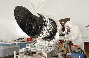
Ball Aerospace was given the responsibility to build the camera and they delivered HiRISE to NASA on December 6, 2004, for integration with the rest of the spacecraft. It was prepared for launch on board the MRO on August 12, 2005, to the cheers of the HiRISE team who were present.

Moon
The Moon is Earth's only known natural satellite,There are a number of near-Earth asteroids including 3753 Cruithne that are co-orbital with Earth: their orbits bring them close to Earth for periods of time but then alter in the long term . These are quasi-satellites and not true moons. For more...
and the Jewel Box cluster. These images helped to calibrate the camera and prepare it for taking pictures of Mars.
On March 10, 2006, MRO achieved Martian orbit and primed HiRISE to acquire some initial images of Mars. The instrument had two opportunities to take pictures of Mars (the first was on March 24, 2006) before MRO entered aerobraking, during which time the camera was turned off for six months. It was turned on successfully September 27, and took its first high-resolution pictures of Mars on September 29.
On October 6, 2006 HiRISE took the first image of Victoria Crater, a site which is also under study by the Opportunity rover
Opportunity rover
Opportunity, MER-B , is a robotic rover on the planet Mars, active since 2004. It is the remaining rover in NASA's ongoing Mars Exploration Rover Mission...
.
In February 2007 seven detectors showed signs of degradation, with one IR channel almost completely degraded, and one other showing advanced signs of degradation. The problems appear to disappear when higher temperatures are used to take pictures with the camera. As of March, the degradation appeared to have stabilized, but the underlying cause remained unknown. Subsequent experiments with the Engineering Model (EM) at Ball Aerospace provided definitive evidence for the cause: contamination in the analog-to-digital converters (ADCs) which results in flipping bits to create the apparent noise or bad data in the images, combined with design flaws leading to delivery of poor analog waveforms to the ADCs. Further work showed that the degradation can be reversed by heating the ADCs.
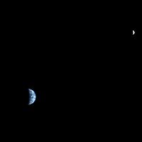
On 2007-10-03, HiRISE was turned toward Earth
Earth
Earth is the third planet from the Sun, and the densest and fifth-largest of the eight planets in the Solar System. It is also the largest of the Solar System's four terrestrial planets...
, and took a picture of it and the Moon
Moon
The Moon is Earth's only known natural satellite,There are a number of near-Earth asteroids including 3753 Cruithne that are co-orbital with Earth: their orbits bring them close to Earth for periods of time but then alter in the long term . These are quasi-satellites and not true moons. For more...
. In a full-resolution color image, Earth was 90 pixels across and the Moon was 24 pixels across from a distance of 142 million km.
On May 25, 2008, HiRISE imaged NASA's Mars Phoenix Lander
Phoenix (spacecraft)
Phoenix was a robotic spacecraft on a space exploration mission on Mars under the Mars Scout Program. The Phoenix lander descended on Mars on May 25, 2008...
parachuting down to Mars. It was the first time that a spacecraft imaged the final descent of another spacecraft onto a planetary body.
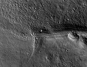
On April 1, 2010, NASA released the first images under the HiWish program in which just plain folk suggested places for HiRISE to photograph. One of the eight locations was Aureum Chaos. The first image below gives a wide view of the area. The next two images are from the HiRISE image.
Purpose

The general public will soon be allowed to request sites for the HiRISE camera to capture. For this reason, and due to the unprecedented access of pictures to the general public, shortly after they have been received and processed, the camera has been given the philosophy, "The People's Camera".
Design
Charge-coupled device
A charge-coupled device is a device for the movement of electrical charge, usually from within the device to an area where the charge can be manipulated, for example conversion into a digital value. This is achieved by "shifting" the signals between stages within the device one at a time...
camera. Because of this, it achieves a resolution
Angular resolution
Angular resolution, or spatial resolution, describes the ability of any image-forming device such as an optical or radio telescope, a microscope, a camera, or an eye, to distinguish small details of an object...
of 1 microradian
Radian
Radian is the ratio between the length of an arc and its radius. The radian is the standard unit of angular measure, used in many areas of mathematics. The unit was formerly a SI supplementary unit, but this category was abolished in 1995 and the radian is now considered a SI derived unit...
, or 0.3 meter at a height of 300 km. (For comparison purposes, satellite images on Google Maps
Google Maps
Google Maps is a web mapping service application and technology provided by Google, free , that powers many map-based services, including the Google Maps website, Google Ride Finder, Google Transit, and maps embedded on third-party websites via the Google Maps API...
are available to 1 meter.) It can image in three color bands, 400–600 nm (blue
Blue
Blue is a colour, the perception of which is evoked by light having a spectrum dominated by energy with a wavelength of roughly 440–490 nm. It is considered one of the additive primary colours. On the HSV Colour Wheel, the complement of blue is yellow; that is, a colour corresponding to an equal...
-green
Green
Green is a color, the perception of which is evoked by light having a spectrum dominated by energy with a wavelength of roughly 520–570 nanometres. In the subtractive color system, it is not a primary color, but is created out of a mixture of yellow and blue, or yellow and cyan; it is considered...
or B-G), 550–850 nm (red
Red
Red is any of a number of similar colors evoked by light consisting predominantly of the longest wavelengths of light discernible by the human eye, in the wavelength range of roughly 630–740 nm. Longer wavelengths than this are called infrared , and cannot be seen by the naked eye...
) and 800–1,000 nm (near infrared or NIR).
HiRISE incorporates a 0.5-meter primary mirror, the largest optical telescope ever sent beyond Earth's orbit. The mass of the instrument is 64.2 kg.
Red color images are at 20,048 pixel
Pixel
In digital imaging, a pixel, or pel, is a single point in a raster image, or the smallest addressable screen element in a display device; it is the smallest unit of picture that can be represented or controlled....
s wide (6 km in a 300 km orbit), and Green-Blue and NIR are at 4,048 pixels wide (1.2 km). HiRISE's onboard computer reads out these lines in time with the orbiter's ground speed
Ground speed
Ground speed is the speed of an aircraft relative to the ground. Information displayed to passengers through the entertainment system often gives the aircraft groundspeed rather than airspeed....
, meaning the images are potentially unlimited in height. Practically this is limited by the onboard computer's 28 Gb
Gigabit
The gigabit is a multiple of the unit bit for digital information or computer storage. The prefix giga is defined in the International System of Units as a multiplier of 109 , and therefore...
memory capacity. The nominal maximum size of red images (compressed to 8 bits per pixel) is about 20,000 × 126,000 pixels, or 2520 megapixels and 4,000 × 126,000 pixels (504 megapixels) for the narrower images of the B-G and NIR bands. A single uncompressed image uses up to 28 Gb. However, these images are transmitted compressed,with a typical max size of 11.2 Gigabits. These images are released to the general public on the HiRISE website via a new format called JPEG 2000
JPEG 2000
JPEG 2000 is an image compression standard and coding system. It was created by the Joint Photographic Experts Group committee in 2000 with the intention of superseding their original discrete cosine transform-based JPEG standard with a newly designed, wavelet-based method...
.
To facilitate the mapping of potential landing sites, HiRISE can produce stereo pairs of images from which the topography can be measured to an accuracy of 0.25 meter.
Images naming conventions
HIRISE images are available to the public, so it can be useful to know how they are named. This is an excerpt from the official documentation:Name:
ppp_oooooo_tttt_ffff_c.IMG
ppp = Mission Phase:
INT = Integration and Testing
CAL = Calibration Observations
ATL = ATLO Observations
KSC = Kennedy Space Center Observations
SVT = Sequence Verification Test
LAU = Launch
CRU = Cruise Observations
APR = Mars Approach Observations
AEB = Aerobraking Phase
TRA = Transition Phase
PSP = Primary Science Orbit (nov 2006-nov 2008)
REL = Relay phase
E01 = 1st Extended Mission Phase if needed
Exx = Additional extended Missions if needed
oooooo = MRO orbit number
tttt = Target code
ffff Filter/CCD designation:
RED0-RED9 - Red filter CCDs
IR10-IR11 – Near-Infrared filter CCDs
BG12-BG13 – Blue-Green filter CCDs
c = Channel number of CCD (0 or 1)
The target code refers to the latitudinal
position of the center of the planned
observation relative to the start of orbit.
The start of orbit is located at the equator
on the descending side (night side) of the
orbit. A target code of 0000 refers to the
start of orbit. The target code increases in
value along the orbit track ranging from 0000
to 3595. This convention allows the file name
ordering to be time sequential. The first
three digits refers to the number of whole
degrees from the start of orbit, the fourth
digit refers to the fractional degrees rounded
to the nearest 0.5 degrees. Values greater
than 3595 identify observations as off-Mars or
special observations.
Examples of target code:
0000 – planned observation at the equator on descending side of orbit.
0900 – planned observation at the south pole.
1800 – planned observation at the equator on the ascending side (day side) of the orbit.
2700 – planned observation at the north pole.
Off-Mars and Special Observations Values:
4000 – Star Observation
4001 – Phobos Observation
4002 – Deimos Observation
4003 – Special Calibration Observation
External links
- HiRISE official website
- HiBlog, the official HiRISE blog
- Help NASA categorize images taken by HiRISE
- Patterns of Mars - 12 High Resolution Photos by HiRISE on www.time.com
- Browse Map of Images from ASUArizona State UniversityArizona State University is a public research university located in the Phoenix Metropolitan Area of the State of Arizona...