

Happy Valley, Tennessee
Encyclopedia
Happy Valley is an unincorporated community
in Blount County
, Tennessee
, United States
, near the Great Smoky Mountains National Park
. Although it is not a census-designated place
, the ZIP Code Tabulation Area
for the ZIP Code
(37878) that serves Happy Valley had a population of 529 as of the 2000 U.S. Census.
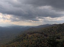
 Happy Valley is situated in a narrow valley of the same name on the northwestern fringe of the Great Smoky Mountains
. Chilhowee Mountain
— an elongate ridge stretching for roughly 35 miles (56.3 km) between the Little Tennessee River
and the Little Pigeon River
watersheds— spans Happy Valley to the north. The valley is walled off to the south by several low ridges— namely Pine Mountain to the southwest and Hatcher Mountain to the southeast— which run roughly parallel to Chilhowee Mountain. Cades Cove
is located opposite Hatcher and Pine Mountain to the south. Happy Valley Ridge provides the valley's eastern barrier, splitting it off from Lake-in-the-Sky and the Top of the World community. Gregory Bald
and the main crest of the western Smokies rises beyond Pine Mountain approximately 3 miles (4.8 km) to the southwest.
Abrams Creek
, which rises in Cades Cove, flows northwestward through the gap between Pine Mountain and Hatcher Mountain. Before it reaches Happy Valley, the creek turns southwestward and flows for several more miles before emptying into the Chilhowee Lake impoundment of the Little Tennessee River. Happy Valley's two major streams— Mill Creek and Bell Branch— are tributaries of Abrams Creek.
Happy Valley Road, which connects U.S. Route 129
with the Look Rock section of Foothills Parkway
, is the only major road access for Happy Valley. The road is accessible immediately southeast of the parkway's terminus along US-129.
 An expedition led by Spanish explorer Juan Pardo
is believed to have passed through Happy Valley in October of 1567. Pardo was attempting to reach the village of Coosa
in northern Georgia via the Tennessee Valley. He left Chiaha
(on Zimmerman's Island, now submerged by Douglas Lake) on October 13, marching southwest across the Foothills of the Great Smokies. He crossed Little River
at what is now Walland
, and camped at Lake-in-the-Sky. From there, he proceeded across Happy Valley en route to the village of Chalahume at the mouth of Abrams Creek.
In the 18th century, Happy Valley was likely part of a Cherokee
trail system connecting the Overhill
towns along the Little Tennessee to the Tuckaleechee Villages in modern Townsend
and tribal hunting grounds in Cades Cove. The Overhill town of Chilhowee
was situated opposite the mouth of Abrams Creek, and likely succeeded the village of Chalahume reported by Pardo. Abrams Creek was named after Old Abraham of Chilhowee, a prominent Overhill chief in the 1780s.
 Happy Valley's first permanent Euro-American settler, Robert Rhea, arrived in the valley sometime around 1823. Rhea was a veteran of the American Revolution
and the War of 1812
, and sought the land as an ideal place to spend his waning years. For nearly 40 years after Rhea's arrival, Happy Valley was known as Rhea's Valley.
In the 1830s, Cades Cove entrepreneur Daniel D. Foute financed the construction of a road connecting his iron forge in Cades Cove with his resort hotel at Montvale Springs. Known as the Cooper Road after its builder, Joe Cooper, the road followed Abrams Creek from Cades Cove into Happy Valley, crossed Chilhowee Mountain at Murray Gap (near Look Rock), and descended to Montvale Springs. Throughout the 19th century and early 20th century, Cades Cove residents used this road to drive cattle back and forth between markets in Maryville
and the grassy balds
atop the western Smokies.
In the years following the American Civil War
(1861–1865), a large number of settlers migrated from Carter County, Tennessee
to Happy Valley. The valley— which had been known as Rhea Valley— obtained the name "Happy Valley" around this time. The name might be rooted in another place named Happy Valley in Carter County, which was the original home of many of the post-Civil War migrants.
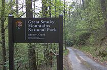 In 1926, conservation groups began buying up land for the creation of the Great Smoky Mountains National Park, which opened in 1934. The park boundary parallels the valley to the south, and includes all of Abrams Creek. A campground and ranger station are now situated at the confluence of Kingfisher Creek and Abrams Creek. Several of the old roads, including the Cooper Road to Cades Cove, the Cane Creek Road to Walland, and the cattle drovers' paths to Gregory Bald, were converted into hiking trails.
In 2006, a group of conservationists known as "Save Chilhowee Mountain" attempted unsuccessfully to block an 80-home development project initiated by Harmony Property Group. Save Chilhowee Mountain argued that drainage from the homes would pollute Abrams Creek, threatening three endangered species of fish. The construction group denied the accusation, claiming it had complied with all local, state, and federal regulations, and had sought technical guidance from independent environmental firms. The group received preliminary approval for construction from the Blount County Planning Commission in May 2006.
Unincorporated area
In law, an unincorporated area is a region of land that is not a part of any municipality.To "incorporate" in this context means to form a municipal corporation, a city, town, or village with its own government. An unincorporated community is usually not subject to or taxed by a municipal government...
in Blount County
Blount County, Tennessee
Blount County is a U.S. county located in the U.S. state of Tennessee. Its population was 123,010 at the United States Census, 2010. The county seat is at Maryville, which is also the county's largest city....
, Tennessee
Tennessee
Tennessee is a U.S. state located in the Southeastern United States. It has a population of 6,346,105, making it the nation's 17th-largest state by population, and covers , making it the 36th-largest by total land area...
, United States
United States
The United States of America is a federal constitutional republic comprising fifty states and a federal district...
, near the Great Smoky Mountains National Park
Great Smoky Mountains National Park
Great Smoky Mountains National Park is a United States National Park and UNESCO World Heritage Site that straddles the ridgeline of the Great Smoky Mountains, part of the Blue Ridge Mountains, which are a division of the larger Appalachian Mountain chain. The border between Tennessee and North...
. Although it is not a census-designated place
Census-designated place
A census-designated place is a concentration of population identified by the United States Census Bureau for statistical purposes. CDPs are delineated for each decennial census as the statistical counterparts of incorporated places such as cities, towns and villages...
, the ZIP Code Tabulation Area
ZIP Code Tabulation Area
ZIP Code Tabulation Areas are statistical entities developed by the United States Census Bureau for tabulating summary statistics from Census 2000. This new entity was developed to overcome the difficulties in precisely defining the land area covered by each ZIP code...
for the ZIP Code
ZIP Code
ZIP codes are a system of postal codes used by the United States Postal Service since 1963. The term ZIP, an acronym for Zone Improvement Plan, is properly written in capital letters and was chosen to suggest that the mail travels more efficiently, and therefore more quickly, when senders use the...
(37878) that serves Happy Valley had a population of 529 as of the 2000 U.S. Census.
Geography
Great Smoky Mountains
The Great Smoky Mountains are a mountain range rising along the Tennessee–North Carolina border in the southeastern United States. They are a subrange of the Appalachian Mountains, and form part of the Blue Ridge Physiographic Province. The range is sometimes called the Smoky Mountains or the...
. Chilhowee Mountain
Chilhowee Mountain
Chilhowee Mountain is a low ridge at the outer edge of the Great Smoky Mountains that stretches between the Little Tennessee River to the west and the Little Pigeon River watershed to the east...
— an elongate ridge stretching for roughly 35 miles (56.3 km) between the Little Tennessee River
Little Tennessee River
The Little Tennessee River is a tributary of the Tennessee River, approximately 135 miles long, in the Appalachian Mountains in the southeastern United States.-Geography:...
and the Little Pigeon River
Little Pigeon River
The Little Pigeon River is the name of several rivers in the United States:*Little Pigeon River in Indiana*Little Pigeon River — three rivers of that name in Michigan*Little Pigeon River in Tennessee...
watersheds— spans Happy Valley to the north. The valley is walled off to the south by several low ridges— namely Pine Mountain to the southwest and Hatcher Mountain to the southeast— which run roughly parallel to Chilhowee Mountain. Cades Cove
Cades Cove
Cades Cove is an isolated valley located in the Tennessee section of Great Smoky Mountains National Park, USA. The valley was home to numerous settlers before the formation of the national park...
is located opposite Hatcher and Pine Mountain to the south. Happy Valley Ridge provides the valley's eastern barrier, splitting it off from Lake-in-the-Sky and the Top of the World community. Gregory Bald
Gregory Bald
Gregory Bald is a mountain on the western fringe of the Great Smoky Mountains. It has an elevation of 4,949 feet above sea level. The mountain's majestic summit makes it a popular hiking destination....
and the main crest of the western Smokies rises beyond Pine Mountain approximately 3 miles (4.8 km) to the southwest.
Abrams Creek
Abrams Falls Trail
The Abrams Falls Trail is an American hiking trail, in the Great Smoky Mountains National Park of Blount County, Tennessee. The trail runs parallel to Abrams Creek and passes Abrams Falls, one of the most voluminous waterfalls in the national park, before terminating at a junction with the Hatcher...
, which rises in Cades Cove, flows northwestward through the gap between Pine Mountain and Hatcher Mountain. Before it reaches Happy Valley, the creek turns southwestward and flows for several more miles before emptying into the Chilhowee Lake impoundment of the Little Tennessee River. Happy Valley's two major streams— Mill Creek and Bell Branch— are tributaries of Abrams Creek.
Happy Valley Road, which connects U.S. Route 129
U.S. Route 129
U.S. Route 129 is an offshoot route of U.S. Route 29, which it intersects near Athens, Georgia. US 129 currently runs for 582 miles from Knoxville, Tennessee, to Chiefland, Florida, at U.S. Route 19 and U.S. Route 98. It passes through the states of Tennessee, North Carolina, Georgia and Florida...
with the Look Rock section of Foothills Parkway
Foothills Parkway
The Foothills Parkway is a national parkway which, if completed, will traverse the foothills of the northern Great Smoky Mountains in East Tennessee, located in the Southeastern United States. The 71-mile parkway will ideally connect U.S...
, is the only major road access for Happy Valley. The road is accessible immediately southeast of the parkway's terminus along US-129.
Early history
Juan Pardo (explorer)
Juan Pardo was a Spanish explorer and conquistador who was active in the later half of the sixteenth century. He led a Spanish expedition through what is now North and South Carolina and into eastern Tennessee. He established Fort San Felipe, South Carolina , and the village of Santa Elena on...
is believed to have passed through Happy Valley in October of 1567. Pardo was attempting to reach the village of Coosa
Coosa chiefdom
The Coosa chiefdom was a powerful Native American paramount chiefdom near what are now Gordon and Murray counties in Georgia, in the United States. It was inhabited from about 1400 until about 1600, and dominated several smaller chiefdoms...
in northern Georgia via the Tennessee Valley. He left Chiaha
Chiaha
Chiaha was a horticultural Native American chiefdom located in the lower French Broad River valley in modern East Tennessee, in the southeastern United States. They lived in raised structures within boundaries of several stable villages. These overlooked the fields of maize, beans, squash, and...
(on Zimmerman's Island, now submerged by Douglas Lake) on October 13, marching southwest across the Foothills of the Great Smokies. He crossed Little River
Little River (Tennessee)
Little River is a scenic river in Tennessee which drains a area containing some of the most spectacular scenery in the southeastern United States. The first of the river are all located within the borders of the Great Smoky Mountains National Park...
at what is now Walland
Walland, Tennessee
Walland is an unincorporated community in Blount County, Tennessee, in the Southeastern United States. Walland is the site of a post office and is the place name associated with zip code 37886, which covers an area beyond the Walland community...
, and camped at Lake-in-the-Sky. From there, he proceeded across Happy Valley en route to the village of Chalahume at the mouth of Abrams Creek.
In the 18th century, Happy Valley was likely part of a Cherokee
Cherokee
The Cherokee are a Native American people historically settled in the Southeastern United States . Linguistically, they are part of the Iroquoian language family...
trail system connecting the Overhill
Overhill Cherokee
The term Overhill Cherokee refers to the former Cherokee settlements located in what is now Tennessee in the southeastern United States. The name was given by 18th century European traders and explorers who had to cross the Appalachian Mountains to reach these settlements when traveling from...
towns along the Little Tennessee to the Tuckaleechee Villages in modern Townsend
Townsend, Tennessee
Townsend is a city in Blount County, Tennessee, in the southeastern United States. The population was 244 at the 2000 census. Townsend is one of three "gateways" to the Great Smoky Mountains National Park and the home of several museums and attractions relating to both the natural and human...
and tribal hunting grounds in Cades Cove. The Overhill town of Chilhowee
Chilhowee (Cherokee town)
Chilhowee was a prehistoric and historic Native American site in Blount County and Monroe County, Tennessee, in the southeastern United States...
was situated opposite the mouth of Abrams Creek, and likely succeeded the village of Chalahume reported by Pardo. Abrams Creek was named after Old Abraham of Chilhowee, a prominent Overhill chief in the 1780s.
Settlement
American Revolutionary War
The American Revolutionary War , the American War of Independence, or simply the Revolutionary War, began as a war between the Kingdom of Great Britain and thirteen British colonies in North America, and ended in a global war between several European great powers.The war was the result of the...
and the War of 1812
War of 1812
The War of 1812 was a military conflict fought between the forces of the United States of America and those of the British Empire. The Americans declared war in 1812 for several reasons, including trade restrictions because of Britain's ongoing war with France, impressment of American merchant...
, and sought the land as an ideal place to spend his waning years. For nearly 40 years after Rhea's arrival, Happy Valley was known as Rhea's Valley.
In the 1830s, Cades Cove entrepreneur Daniel D. Foute financed the construction of a road connecting his iron forge in Cades Cove with his resort hotel at Montvale Springs. Known as the Cooper Road after its builder, Joe Cooper, the road followed Abrams Creek from Cades Cove into Happy Valley, crossed Chilhowee Mountain at Murray Gap (near Look Rock), and descended to Montvale Springs. Throughout the 19th century and early 20th century, Cades Cove residents used this road to drive cattle back and forth between markets in Maryville
Maryville, Tennessee
Maryville is the county seat of Blount County, Tennessee, in the Southeastern United States. The city is located south of Knoxville. Maryville's population was 27,258 at the 2010 census. It is included in the Knoxville Metropolitan Area. Maryville has received a number of accolades for its...
and the grassy balds
Appalachian balds
In the Appalachian Mountains of the eastern United States, balds are mountain summits or crests covered primarily by thick vegetation of native grasses or shrubs occurring in areas where heavy forest growth would be expected....
atop the western Smokies.
In the years following the American Civil War
American Civil War
The American Civil War was a civil war fought in the United States of America. In response to the election of Abraham Lincoln as President of the United States, 11 southern slave states declared their secession from the United States and formed the Confederate States of America ; the other 25...
(1861–1865), a large number of settlers migrated from Carter County, Tennessee
Carter County, Tennessee
Carter County is a county located in the U.S. state of Tennessee. As of 2010, the population was 57,424. Its county seat is Elizabethton.Carter County is part of the Johnson City Metropolitan Statistical Area, which is a component of the Johnson City–Kingsport–Bristol, TN-VA Combined...
to Happy Valley. The valley— which had been known as Rhea Valley— obtained the name "Happy Valley" around this time. The name might be rooted in another place named Happy Valley in Carter County, which was the original home of many of the post-Civil War migrants.
The national park and preservation
In 2006, a group of conservationists known as "Save Chilhowee Mountain" attempted unsuccessfully to block an 80-home development project initiated by Harmony Property Group. Save Chilhowee Mountain argued that drainage from the homes would pollute Abrams Creek, threatening three endangered species of fish. The construction group denied the accusation, claiming it had complied with all local, state, and federal regulations, and had sought technical guidance from independent environmental firms. The group received preliminary approval for construction from the Blount County Planning Commission in May 2006.