
Halfway, Oregon
Encyclopedia
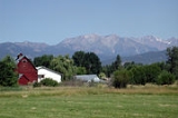
Halfway is a city in Baker County
, Oregon
, United States
. This town took its name from the location of its post office, on the Alexander Stalker ranch, half way between Pine
and Cornucopia
. The population was 337 at the 2000 census, and grew to an estimated 355 by 2009.
and Shoshone
tribes.
It was explored and mapped by Benjamin Bonneville
in the 1830s, and first settled by Euro-Americans in the 1860s. The smaller national forest
s now combined into the local Wallowa–Whitman National Forest were created in 1908.
While a post office was established in 1887, the town was plat
ted in another location in 1907, the post office moved there in 1908, and it incorporated in 1909.
The town has always been primarily a farming and ranching community. There was a small gold rush to nearby Cornucopia
, now a ghost town
, and some timber
industry in the early 20th century. Major employer the Idaho Power Company
now operates three hydroelectric dams on the Snake River
.
Halfway earned a place in the history of the dot-com era
when it received, and accepted in December 1999, an offer to rename itself Half.com, Oregon in exchange for $100,000, computers for the school, and other financial subsidies. Since the company Half.com
was bought by eBay
in February 2001, it has not been made clear whether eBay would honor the numerous financial considerations.
The original financial conditions that led to the city accepting Half.com's offer returned in 2004, when the company owning a promissory note secured by its fairgrounds and improvements demanded payment of over $530,000. Foreclosure of the 83-year-old fairgrounds would endanger the future of the yearly Baker County Fair and the annual rodeo
.
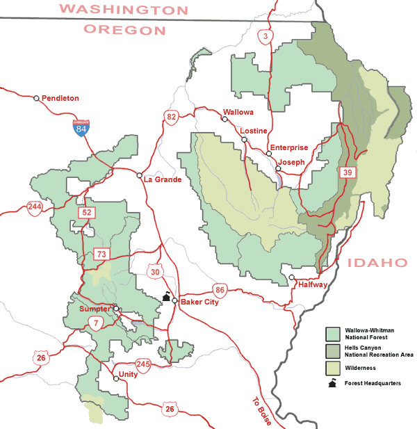 Halfway is located 54 miles (86.9 km) east of Baker City
, along Oregon Route 86
.
According to the United States Census Bureau
, the city has a total area of 0.4 square miles (1 km²), all land.
 As of the census
of 2000, there were 337 people, 159 households, and 86 families residing in the city. The population density
was 789.5 people per square mile (302.6/km²). There were 196 housing units at an average density of 459.1 per square mile (176.0/km²). The racial makeup of the city was 95.25% White, 2.97% Native American, 0.30% from other races
, and 1.48% from two or more races. Hispanic or Latino of any race were 2.08% of the population.
There were 159 households out of which 24.5% had children under the age of 18 living with them, 43.4% were married couples
living together, 9.4% had a female householder with no husband present, and 45.3% were non-families. 39.6% of all households were made up of individuals and 24.5% had someone living alone who was 65 years of age or older. The average household size was 2.12 and the average family size was 2.91.
In the city the population was spread out with 25.2% under the age of 18, 4.5% from 18 to 24, 20.5% from 25 to 44, 26.1% from 45 to 64, and 23.7% who were 65 years of age or older. The median age was 45 years. For every 100 females there were 86.2 males. For every 100 females age 18 and over, there were 81.3 males.
The median income for a household in the city was $17,212, and the median income for a family was $27,813. Males had a median income of $23,750 versus $13,194 for females. The per capita income
for the city was $12,997. About 24.5% of families and 28.3% of the population were below the poverty line, including 40.2% of those under age 18 and 29.5% of those age 65 or over.
, the Idaho Power Company
, and the U.S. Forest Service
, which combined to employ over 125 people.
Baker County, Oregon
Baker County is a county located in the U.S. state of Oregon. It is included in the 8 county definition of Eastern Oregon. It is named for Edward Dickinson Baker, a senator from Oregon who was killed at Ball's Bluff, a battle of the Civil War in Virginia in 1861. It was split from the eastern part...
, Oregon
Oregon
Oregon is a state in the Pacific Northwest region of the United States. It is located on the Pacific coast, with Washington to the north, California to the south, Nevada on the southeast and Idaho to the east. The Columbia and Snake rivers delineate much of Oregon's northern and eastern...
, United States
United States
The United States of America is a federal constitutional republic comprising fifty states and a federal district...
. This town took its name from the location of its post office, on the Alexander Stalker ranch, half way between Pine
Pine, Oregon
Pine is an unincorporated community in Baker County, Oregon, United States. It is located about southeast of the city of Halfway, near Oregon Route 86....
and Cornucopia
Cornucopia, Oregon
Cornucopia is a ghost town of the gold mining boom of the 1880s in Eastern Oregon, United States. The name of the town was chosen since it meant "Horn of Plenty". Gold was discovered in Cornucopia in 1884. The town was platted in 1886. It is located east of Baker City high in the mountains of Pine...
. The population was 337 at the 2000 census, and grew to an estimated 355 by 2009.
History
The area was originally used as hunting territory by the Nez Perce, UmatillaUmatilla (tribe)
The Umatilla are a Sahaptin-speaking Native American group living on the Umatilla Indian Reservation, who traditionally inhabited the Columbia Plateau region of the northwestern United States....
and Shoshone
Shoshone
The Shoshone or Shoshoni are a Native American tribe in the United States with three large divisions: the Northern, the Western and the Eastern....
tribes.
It was explored and mapped by Benjamin Bonneville
Benjamin Bonneville
Benjamin Louis Eulalie de Bonneville was a French-born officer in the United States Army, fur trapper, and explorer in the American West...
in the 1830s, and first settled by Euro-Americans in the 1860s. The smaller national forest
United States National Forest
National Forest is a classification of federal lands in the United States.National Forests are largely forest and woodland areas owned by the federal government and managed by the United States Forest Service, part of the United States Department of Agriculture. Land management of these areas...
s now combined into the local Wallowa–Whitman National Forest were created in 1908.
While a post office was established in 1887, the town was plat
Plat
A plat in the U.S. is a map, drawn to scale, showing the divisions of a piece of land. Other English-speaking countries generally call such documents a cadastral map or plan....
ted in another location in 1907, the post office moved there in 1908, and it incorporated in 1909.
The town has always been primarily a farming and ranching community. There was a small gold rush to nearby Cornucopia
Cornucopia, Oregon
Cornucopia is a ghost town of the gold mining boom of the 1880s in Eastern Oregon, United States. The name of the town was chosen since it meant "Horn of Plenty". Gold was discovered in Cornucopia in 1884. The town was platted in 1886. It is located east of Baker City high in the mountains of Pine...
, now a ghost town
Ghost town
A ghost town is an abandoned town or city. A town often becomes a ghost town because the economic activity that supported it has failed, or due to natural or human-caused disasters such as floods, government actions, uncontrolled lawlessness, war, or nuclear disasters...
, and some timber
Timber
Timber may refer to:* Timber, a term common in the United Kingdom and Australia for wood materials * Timber, Oregon, an unincorporated community in the U.S...
industry in the early 20th century. Major employer the Idaho Power Company
Idaho Power Company
Idaho Power Company is a regulated electrical power utility. Its business involves the purchase, sale, generation, transmission and distribution of electricity in eastern Oregon and southern Idaho. It is a subsidiary of IDACORP, Inc...
now operates three hydroelectric dams on the Snake River
Snake River
The Snake is a major river of the greater Pacific Northwest in the United States. At long, it is the largest tributary of the Columbia River, the largest North American river that empties into the Pacific Ocean...
.
Halfway earned a place in the history of the dot-com era
Dot-com bubble
The dot-com bubble was a speculative bubble covering roughly 1995–2000 during which stock markets in industrialized nations saw their equity value rise rapidly from growth in the more...
when it received, and accepted in December 1999, an offer to rename itself Half.com, Oregon in exchange for $100,000, computers for the school, and other financial subsidies. Since the company Half.com
Half.com
Half.com is a subsidiary of eBay, in which sellers offer items at fixed prices, usually items that have a UPC, ISBN or other kind of SKU, rather than rare, old or collectible items...
was bought by eBay
EBay
eBay Inc. is an American internet consumer-to-consumer corporation that manages eBay.com, an online auction and shopping website in which people and businesses buy and sell a broad variety of goods and services worldwide...
in February 2001, it has not been made clear whether eBay would honor the numerous financial considerations.
The original financial conditions that led to the city accepting Half.com's offer returned in 2004, when the company owning a promissory note secured by its fairgrounds and improvements demanded payment of over $530,000. Foreclosure of the 83-year-old fairgrounds would endanger the future of the yearly Baker County Fair and the annual rodeo
Rodeo
Rodeo is a competitive sport which arose out of the working practices of cattle herding in Spain, Mexico, and later the United States, Canada, South America and Australia. It was based on the skills required of the working vaqueros and later, cowboys, in what today is the western United States,...
.
Geography
Baker City, Oregon
Baker City is a city in and the county seat of Baker County, Oregon, United States. It was named after Edward D. Baker. The population was 9,828 at the 2010 census.-History:...
, along Oregon Route 86
Oregon Route 86
Oregon Route 86 is an Oregon state highway running from Interstate 84 at Baker City to the Idaho state line at Oxbow . OR 86 comprises most of the Baker-Copperfield Highway No. 12 . It is long and runs east–west. OR 86 has an unsigned spur near Halfway, which runs for...
.
According to the United States Census Bureau
United States Census Bureau
The United States Census Bureau is the government agency that is responsible for the United States Census. It also gathers other national demographic and economic data...
, the city has a total area of 0.4 square miles (1 km²), all land.
Demographics
Census
A census is the procedure of systematically acquiring and recording information about the members of a given population. It is a regularly occurring and official count of a particular population. The term is used mostly in connection with national population and housing censuses; other common...
of 2000, there were 337 people, 159 households, and 86 families residing in the city. The population density
Population density
Population density is a measurement of population per unit area or unit volume. It is frequently applied to living organisms, and particularly to humans...
was 789.5 people per square mile (302.6/km²). There were 196 housing units at an average density of 459.1 per square mile (176.0/km²). The racial makeup of the city was 95.25% White, 2.97% Native American, 0.30% from other races
Race (United States Census)
Race and ethnicity in the United States Census, as defined by the Federal Office of Management and Budget and the United States Census Bureau, are self-identification data items in which residents choose the race or races with which they most closely identify, and indicate whether or not they are...
, and 1.48% from two or more races. Hispanic or Latino of any race were 2.08% of the population.
There were 159 households out of which 24.5% had children under the age of 18 living with them, 43.4% were married couples
Marriage
Marriage is a social union or legal contract between people that creates kinship. It is an institution in which interpersonal relationships, usually intimate and sexual, are acknowledged in a variety of ways, depending on the culture or subculture in which it is found...
living together, 9.4% had a female householder with no husband present, and 45.3% were non-families. 39.6% of all households were made up of individuals and 24.5% had someone living alone who was 65 years of age or older. The average household size was 2.12 and the average family size was 2.91.
In the city the population was spread out with 25.2% under the age of 18, 4.5% from 18 to 24, 20.5% from 25 to 44, 26.1% from 45 to 64, and 23.7% who were 65 years of age or older. The median age was 45 years. For every 100 females there were 86.2 males. For every 100 females age 18 and over, there were 81.3 males.
The median income for a household in the city was $17,212, and the median income for a family was $27,813. Males had a median income of $23,750 versus $13,194 for females. The per capita income
Per capita income
Per capita income or income per person is a measure of mean income within an economic aggregate, such as a country or city. It is calculated by taking a measure of all sources of income in the aggregate and dividing it by the total population...
for the city was $12,997. About 24.5% of families and 28.3% of the population were below the poverty line, including 40.2% of those under age 18 and 29.5% of those age 65 or over.
Economy
In 2001, the three largest employers in Halfway were the Pine Eagle School DistrictPine Eagle High School
-Academics:In 2008, 86% of the school's seniors received their high school diploma. Of 22 students, 19 graduated, 2 dropped out, and 1 are still in high school....
, the Idaho Power Company
Idaho Power Company
Idaho Power Company is a regulated electrical power utility. Its business involves the purchase, sale, generation, transmission and distribution of electricity in eastern Oregon and southern Idaho. It is a subsidiary of IDACORP, Inc...
, and the U.S. Forest Service
United States Forest Service
The United States Forest Service is an agency of the United States Department of Agriculture that administers the nation's 155 national forests and 20 national grasslands, which encompass...
, which combined to employ over 125 people.
Notable people
- Babette Beatty, the first Sports Illustrated Swimsuit Issue cover model.
- Barnaby KeeneyBarnaby KeeneyBarnaby Conrad Keeney was president of Brown University from 1955 to 1966 where he was known and loved by the student body for openness and his dry wit...
, former president of Brown University - Robert S. SummersRobert S. SummersRobert Samuel Summers is the former William G. McRoberts Research Professor in the Administration of the Law at the Cornell Law School in Ithaca, NY. Summers retired in 2011.- Biography :Robert Summers was born in Halfway, Oregon in 1933...
, professor at Cornell Law School
External links
- Listing for Halfway in the Oregon Blue BookOregon Blue BookThe Oregon Blue Book is the official directory and fact book for the U.S. state of Oregon copyrighted by the Oregon Secretary of State and published by the Office of the Secretary's Archives Division. As Governor Ted Kulongoski notes in his introduction for the 2005–2006 edition, it "provides...
- Halfway information from Hells CanyonHells CanyonHells Canyon is a wide canyon located along the border of eastern Oregon and western Idaho in the United States. It is North America's deepest river gorge at and part of the Hells Canyon National Recreation Area....
Chamber of Commerce