

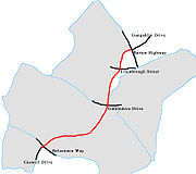
Gungahlin Drive Extension
Encyclopedia
Canberra
Canberra is the capital city of Australia. With a population of over 345,000, it is Australia's largest inland city and the eighth-largest city overall. The city is located at the northern end of the Australian Capital Territory , south-west of Sydney, and north-east of Melbourne...
, Australia
Australia
Australia , officially the Commonwealth of Australia, is a country in the Southern Hemisphere comprising the mainland of the Australian continent, the island of Tasmania, and numerous smaller islands in the Indian and Pacific Oceans. It is the world's sixth-largest country by total area...
. It is 9 kilometres long and extended the previously existing Gungahlin Drive from the Barton Highway
Barton Highway
The Barton Highway is a short highway in New South Wales and the Australian Capital Territory, Australia.The Barton Highway connects Canberra to the Hume Highway at Yass, and it is part of the route from Melbourne to Canberra....
in the district of Gungahlin
Gungahlin
Gungahlin is a name of a district and the northernmost town centre of Canberra, Australia. Gungahlin is situated 10 km north of Canberra's city centre and is one of five satellites of Canberra including Woden, Tuggeranong, Weston Creek and Belconnen. Currently Gungahlin comprises 11 suburbs,...
to the Glenloch Interchange
Glenloch Interchange
Glenloch Interchange is Canberra's only major interchange which connects Tuggeranong Parkway with Parkes Way, William Hovell Drive and Caswell Drive . Following a major reconstruction lasting from 2007 to mid 2008, the interchange now operates without traffic lights...
to connect with Parkes Way
Parkes Way, Canberra
Parkes Way is a road in Canberra, Australia, which runs east-west between Kings Avenue and the Glenloch Interchange. At Glenloch Interchange it intersects with William Hovell Drive, Tuggeranong Parkway and Caswell Drive.The road is a freeway from Glenloch Interchange to the Commonwealth Avenue...
and the Tuggeranong Parkway
Tuggeranong Parkway
The Tuggeranong Parkway is a major dual carriageway link in Canberra, Australia. Often referred to as "The Parkway" by locals, the Tuggeranong Parkway links Civic to the southern Canberra metro district of Tuggeranong, and is a bypass road to the Woden Valley-Weston Creek district of Canberra...
. The extended Gungahlin Drive is 16.2km in length and has a speed limit of 80km/h. While the first stage of the project was completed in 2008 as planned, the majority of the road consisted of only a single lane in each direction. Work commenced in 2009 to construct an additional carriageway
Carriageway
A carriageway consists of a width of road on which a vehicle is not restricted by any physical barriers or separation to move laterally...
where required, to widen the road to two lanes in each direction, including construction of 9 new bridges. This second stage work has now been completed, and the four lane extension was opened on 7 October 2011.
History
The Gungahlin Drive Extension project had its genesis in planning that emphasised the motor car as the primary means of travel in Canberra. This philosophy is shown in planning studies dating from the 1960s.In 1991, the ACT Liberal Government began consultations for a John Dedman Parkway project, which would have gone from the Barton Highway to Belconnen Way. This project was subsequently renamed the Gungahlin Drive Extension, with the road proceeding to the Glenloch Interchange.
This Gungahlin Drive Extension route and the Majura Road upgrading (between the Monaro Highway
Monaro Highway
The Monaro Highway is a state highway in New South Wales, the Australian Capital Territory and Victoria, Australia. The Victorian section was formerly known as the Cann Valley Highway until the 1980s....
and Federal Highway
Federal Highway (Australia)
The Federal Highway is a short highway in New South Wales and the Australian Capital Territory in Australia. It is a part of the Sydney-Canberra National Highway link....
), are two transport routes that are on the drawing board as north-south routes. Some consider the GDE route as a crucial link in Canberra's transport network while others consider it a white elephant and support other transport alternatives, such as light rail between Gungahlin and Civic.
The ACT Labor Government won election in 2001 promising a GDE alignment that would travel west of the Australian Institute of Sport AIS
Australian Institute of Sport
The Australian Institute of Sport is a sports training institution in Australia with world class facilities and support services. The Institute's headquarters is situated in Canberra, the capital city of Australia. The 66.0 hectare site campus is in the northern suburb of Bruce, but some of the...
. However, the Commonwealth Government's National Capital Authority
National Capital Authority
The National Capital Authority is a body of the Australian Government that was established to manage the Commonwealth's interest in the planning and development of Canberra as the capital city of Australia....
decided in December 2002 to support an alignment east of the AIS as the preferred route. On 16 January 2003 the ACT Government fell in with the NCA and decided to investigate options for an Eastern Alignment for GDE in the vicinity of the AIS, as well as reviewing options for the alignment in the Aranda
Aranda, Australian Capital Territory
Aranda is a suburb in the Canberra district of Belconnen. It is the eastern most suburb in Belconnen, located at the western foot of Black Mountain. Bounded on two sides by nature park, the suburb is characterised by its bush setting...
Precinct.
Supporters of natural parkland campaigned to have the road building stopped - staging a number of demonstrations. However the ACT Government determined that the road be built, and subsequently changed the law to prevent further opposition from community groups.
Although the GDE has now been completed, it remains controversial, with the road originally being built to 2-lane standard rather than four; leaving southbound and northbound commuters with lengthy delays each morning and afternoon.
Work commenced in October 2009 to widen the 2 lane sections to 4 lanes as originally planned. The area near the south bound lanes leading into the Glenloch interchange was the first area to be widened as this area bears the heaviest traffic load during peak times.
The road has now been completed to a 4 lane freeway standard.
Exit list
| Gunghalin Drive Extension | |||
| Northbound | Distance to Gunghalin (km) |
Distance to Tugarnong (km) |
Southbound |
| Start Gunghalin Drive Extension | 660 | 4 | End Gunghalin Drive Extension |
 Traffic Lights (clockwise from highway) Traffic Lights (clockwise from highway) Federal Highway Federal Highway (Australia) The Federal Highway is a short highway in New South Wales and the Australian Capital Territory in Australia. It is a part of the Sydney-Canberra National Highway link....  to Watson to WatsonWatson, Australian Capital Territory Watson is a suburb of Canberra, Australia in the North Canberra district. Watson is named after the third Prime Minister of Australia, John Christian Watson. The suburb name was gazetted on 7 April 1960. Streets in Watson are named after Australian judges and other legal professionals... , Goulburn Goulburn, New South Wales Goulburn is a provincial city in the Southern Tablelands of New South Wales, Australia in Goulburn Mulwaree Council Local Government Area. It is located south-west of Sydney on the Hume Highway and above sea-level. On Census night 2006, Goulburn had a population of 20,127 people... and Sydney Sydney Sydney is the most populous city in Australia and the state capital of New South Wales. Sydney is located on Australia's south-east coast of the Tasman Sea. As of June 2010, the greater metropolitan area had an approximate population of 4.6 million people... Parks way to Canberra City Centre Canberra Canberra is the capital city of Australia. With a population of over 345,000, it is Australia's largest inland city and the eighth-largest city overall. The city is located at the northern end of the Australian Capital Territory , south-west of Sydney, and north-east of Melbourne... ,  |
|||
Protests
When the Gungahlin Drive Extension plans were made public, there were protests by various groups in order to stop or delay work on the road. The main protests came from a group called "Save The Ridge". This group were angry about the destruction of the floraFlora
Flora is the plant life occurring in a particular region or time, generally the naturally occurring or indigenous—native plant life. The corresponding term for animals is fauna.-Etymology:...
and fauna
Fauna
Fauna or faunæ is all of the animal life of any particular region or time. The corresponding term for plants is flora.Zoologists and paleontologists use fauna to refer to a typical collection of animals found in a specific time or place, e.g. the "Sonoran Desert fauna" or the "Burgess shale fauna"...
that would occur with the GDE running through the Bruce
Bruce, Australian Capital Territory
Bruce is a suburb of Canberra, Australian Capital Territory, Australia. Bruce was gazetted as a division on 6 June 1968 in recognition of Viscount Stanley Melbourne Bruce, the first Chancellor of the Australian National University and eighth Prime Minister of Australia. S. M. Bruce served as...
/ O'Connor
O'Connor, Australian Capital Territory
O'Connor is a suburb of Canberra, Australia in the North Canberra district. It was named after Richard Edward O'Connor , who was a judge in the High Court and a founder of the Australian constitution. Street names in O'Connor are named after explorers, Australian flora, legislators and pioneers...
Ridge. Meanwhile, another group called GDE Now! was formed, with a slogan 'Pave the Ridge'.
In 2004 Save The Ridge had a legal victory with the ACT Government in relation to local planning laws. The ACT Government then passed a new law with the purpose of overriding further legal challenges at the local level.
In 2005 Save The Ridge took the ACT Government
Australian Capital Territory Legislative Assembly
The Australian Capital Territory Legislative Assembly is the unicameral legislature of the Australian Capital Territory...
and the National Capital Authority
National Capital Authority
The National Capital Authority is a body of the Australian Government that was established to manage the Commonwealth's interest in the planning and development of Canberra as the capital city of Australia....
to the Federal Court of Australia
Federal Court of Australia
The Federal Court of Australia is an Australian superior court of record which has jurisdiction to deal with most civil disputes governed by federal law , along with some summary criminal matters. Cases are heard at first instance by single Judges...
in a further effort to have the project shut down. In September 2005 the Federal Court ruled in favour of the NCA and the ACT Government to give the go-ahead for the project to resume.
On 10 December 2006, during Stage 1 of the GDE opening, Save The Ridge again protested against the road, and called for an immediate halt to the rest of the construction taking place. They called the GDE "one of the most expensive non tunnelled single lane roads per kilometre in Australia
Australia
Australia , officially the Commonwealth of Australia, is a country in the Southern Hemisphere comprising the mainland of the Australian continent, the island of Tasmania, and numerous smaller islands in the Indian and Pacific Oceans. It is the world's sixth-largest country by total area...
's history."
Bridge collapse
On 14 August 2010, the eastern duplication bridge of the GDE, over the Barton Highway, partially collapsed, the new bridge was under construction when it collapsed. ACT Police, ACT Ambulance Service and the ACT Fire Brigade attended the scene and freed one man who was trapped under the rubble. At least 9 people were taken to the Canberra HospitalCanberra Hospital
The Canberra Hospital is a public hospital located in Garran, Canberra. It is a tertiary level centre with 500 beds and caters to a population of about 520,000...
for treatment and another 5 were injured however there were no critical injuries, all those affected were working on a new span of the bridge. The Barton Highway
Barton Highway
The Barton Highway is a short highway in New South Wales and the Australian Capital Territory, Australia.The Barton Highway connects Canberra to the Hume Highway at Yass, and it is part of the route from Melbourne to Canberra....
and northern GDE were closed for several hours as investigations commenced.
The Barton Highway was reopened on 9 September 2010 after investigations and removal of the collapsed bridge.
Construction on the second span started afresh at the end of December 2010 with all contractors taking on board the recommendations made by ACT Workcover relating to worker safety and materials to ensure that the collapse of the old span is not repeated.
See also
- Freeways in AustraliaFreeways in AustraliaThis is a list of freeways and motorways in Australia, sorted by states and territories and their corresponding routes. This list includes toll roads such as the CityLink freeway system in Melbourne. This list has over 70 entries...
- Freeways in Canberra