
Aranda, Australian Capital Territory
Encyclopedia
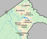
Aranda is a suburb in the Canberra
district of Belconnen
. It is the eastern most suburb in Belconnen, located at the western foot of Black Mountain
. Bounded on two sides by nature park, the suburb is characterised by its bush setting. During the planning and development of the suburb, a large proportion of large native trees – predominantly eucalypts
– were left in place.
The suburb derives its name from the Arrernte
tribe of Central Australia
, previously known as Arunta, which means 'White Cockatoo
'. The streets in Aranda are named after Aboriginal tribal groups from around Australia. The suburb comprises an area of 160ha and in 1967 was the first suburb in Belconnen to be settled. On Census night 2006, Aranda had a population of 2,412 people.
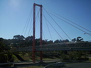
A small plaque at the Aranda District playing fields near the suspension bridge over Belconnen Way marks the settlement of the suburb as the first development in the Belconnen district. It reads:
 Aranda is located in the south east of Belconnen. It is bounded by Caswell Drive on the east, separating the suburb from Black Mountain Nature Park, Belconnen Way to the north, Bindubi Street to the west and Aranda Bushland to the south. A pedestrian bridge crossing the six-lane Belconnen Way connects the suburb with the suburb of Bruce
to the north. The suburbs of Cook
and Macquarie
are located to Aranda’s west on the opposite side of Bindubi Street.
Aranda is located 7km to the west of Civic
along Belconnen Way. Bandjalong Crescent, a curved bell shaped street is the main street passing through the suburb, connecting Caswell Drive with Bindubi Street. A number of community facilities are located in the centre of the curve.
A bicycle path along Bindubi Street connects Aranda with the Canberra bike path network. A walking path runs through a reserve along the spine of the suburb and connects with the footbridge to the suburb of Bruce. A walking track over Black Mountain connects Aranda with the CSIRO and the Australian National University.
Aranda is served by buses which connect Civic with Belconnen Town Centre via Cook and Macquarie. Buses to Belconnen also stop on Belconnen Way and at the Calvary Hospital located in Bruce without passing through the suburb.
 A number of community facilities are located close to one another near the intersections of Bandjalong and Bindel Streets. These include two primary schools (Aranda Primary School and St. Vincent's Catholic
school), two churches and a pre-school.
The local shops have been in decline for a number of years and, unlike most other suburbs
in Canberra, has not had a general store since the 1980s. The individual shops have been unleased for a number of years and the site, which is in a serious state of disrepair, may be developed in future as apartments. The Jamison Centre
in nearby Macquarie services the suburb.
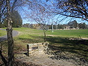
A number of playing fields are located in the north western corner of the suburb including baseball
and soccer fields, as is a Scout hall
. A nursing home is also located on Bindel Street.
The Friends of Aranda Bushland group is active in the suburb and there is an active Neighbourhood Watch group.
Aranda Residents Group is active in representing the interests of its residents. Between 2000–2005 residents have been vocal opponents on major planning
issues including the Gungahlin Drive Extension and the proposed ‘A10’ planning reforms. The Gungahlin Drive Extension, currently under construction,is a four lane road which will connect Gungahlin Drive in Gungahlin
with Parkes Way near Lake Burley Griffin
. The road will travel along the route of Caswell Drive, a two lane road separating Black Mountain reserve from Aranda and will increase the amount of traffic travelling past the suburb. ‘A10’ is the name of a zoning scheme which would allow the construction of medium density housing in residential areas within close proximity to local shops. Many residents of Aranda are concerned that such developments are inappropriate in quiet streets such as those in their suburbs.
, and the ACT Legislative Assembly
Electorate of Ginninderra.
In the 2004 Federal Election the Aranda booth was won by Australian Labor Party
with a stronger than average showing for the Australian Greens
(House of Representatives
Labor 56%, Liberal
25%, Greens 16% ; Senate
Labor 41%, Liberal 26%, Greens 29% ).
Age. Mostly the
rocks are greywacke
formed on a continental slope, but also have bands of the Acton Shale
Member, a grey to black laminated shale. The Acton Shale contains graptolite
s.
The Deakin Fault cuts through the south west of the Aranda Bushland. South west of the fault is Silurian
age Mount Painter Volcanics tuff and ashstone.
Canberra
Canberra is the capital city of Australia. With a population of over 345,000, it is Australia's largest inland city and the eighth-largest city overall. The city is located at the northern end of the Australian Capital Territory , south-west of Sydney, and north-east of Melbourne...
district of Belconnen
Belconnen
Belconnen is a district of Canberra, the capital city of Australia, comprising 25 suburbs with 29,900 dwellings housing 82,247 people of the 311,518 people in the Australian Capital Territory ....
. It is the eastern most suburb in Belconnen, located at the western foot of Black Mountain
Black Mountain (Australian Capital Territory)
Black Mountain is situated close to the central business district of Australia's capital city Canberra. Like all major hills in Canberra it is protected from development by the Canberra Nature Park. It is covered in native bushland and is a haven to native wildlife.With its peak at 811.987m AHD,...
. Bounded on two sides by nature park, the suburb is characterised by its bush setting. During the planning and development of the suburb, a large proportion of large native trees – predominantly eucalypts
Eucalyptus
Eucalyptus is a diverse genus of flowering trees in the myrtle family, Myrtaceae. Members of the genus dominate the tree flora of Australia...
– were left in place.
The suburb derives its name from the Arrernte
Arrernte people
The Arrernte people , known in English as the Aranda or Arunta, are those Indigenous Australians who are the original custodians of Arrernte lands in the central area of Australia around Mparntwe or Alice Springs in the Northern Territory. The Arrernte tribe has lived there for more than 20,000 years...
tribe of Central Australia
Central Australia
Central Australia/Alice Springs Region is one of the five regions in the Northern Territory. The term Central Australia is used to describe an area centred on Alice Springs in Australia. It is sometimes referred to as Centralia; likewise the people of the area are sometimes called Centralians...
, previously known as Arunta, which means 'White Cockatoo
Cockatoo
A cockatoo is any of the 21 species belonging to the bird family Cacatuidae. Along with the Psittacidae and the Strigopidae , they make up the parrot order Psittaciformes . Placement of the cockatoos as a separate family is fairly undisputed, although many aspects of the other living lineages of...
'. The streets in Aranda are named after Aboriginal tribal groups from around Australia. The suburb comprises an area of 160ha and in 1967 was the first suburb in Belconnen to be settled. On Census night 2006, Aranda had a population of 2,412 people.
A small plaque at the Aranda District playing fields near the suspension bridge over Belconnen Way marks the settlement of the suburb as the first development in the Belconnen district. It reads:
- "This tablet marks the inauguration of development of the district of Belconnen by the Minister of State for the Interior The Honourable J. D. Anthony, M.P. 23rd June 1966"
Location and transport
Bruce, Australian Capital Territory
Bruce is a suburb of Canberra, Australian Capital Territory, Australia. Bruce was gazetted as a division on 6 June 1968 in recognition of Viscount Stanley Melbourne Bruce, the first Chancellor of the Australian National University and eighth Prime Minister of Australia. S. M. Bruce served as...
to the north. The suburbs of Cook
Cook, Australian Capital Territory
Cook is a suburb of Canberra, Australian Capital Territory, Australia. Cook is in the district of Belconnen. On Census night 2006, Cook had a population of 2,817 people....
and Macquarie
Macquarie, Australian Capital Territory
Macquarie is a suburb of Canberra, Australian Capital Territory, Australia. Macquarie was gazetted as a division on 22 June 1967 in recognition of Major-General Lachlan Macquarie, a former Governor of New South Wales. Streets in Macquarie are named after contemporaries of Governor...
are located to Aranda’s west on the opposite side of Bindubi Street.
Aranda is located 7km to the west of Civic
City Centre, Australian Capital Territory
The central business district of Canberra, Australia's capital city, is officially named City . However it is also referred to as Civic, Civic Centre, City Centre, Canberra City and Canberra ....
along Belconnen Way. Bandjalong Crescent, a curved bell shaped street is the main street passing through the suburb, connecting Caswell Drive with Bindubi Street. A number of community facilities are located in the centre of the curve.
A bicycle path along Bindubi Street connects Aranda with the Canberra bike path network. A walking path runs through a reserve along the spine of the suburb and connects with the footbridge to the suburb of Bruce. A walking track over Black Mountain connects Aranda with the CSIRO and the Australian National University.
Aranda is served by buses which connect Civic with Belconnen Town Centre via Cook and Macquarie. Buses to Belconnen also stop on Belconnen Way and at the Calvary Hospital located in Bruce without passing through the suburb.
Facilities
Catholic
The word catholic comes from the Greek phrase , meaning "on the whole," "according to the whole" or "in general", and is a combination of the Greek words meaning "about" and meaning "whole"...
school), two churches and a pre-school.
The local shops have been in decline for a number of years and, unlike most other suburbs
Suburbs of Canberra
The suburbs of Canberra are organised into a hierarchy of districts, town centres, group centres, local suburbs and other industrial areas and villages...
in Canberra, has not had a general store since the 1980s. The individual shops have been unleased for a number of years and the site, which is in a serious state of disrepair, may be developed in future as apartments. The Jamison Centre
Jamison Centre, Australian Capital Territory
Jamison Centre is a designated group centre located in the Canberra suburb of Macquarie. It services the suburbs of Macquarie, Aranda, Bruce, Cook, Page and Weetangera. Places nearby include the West Belconnen Rugby Club and the Big Splash Waterpark....
in nearby Macquarie services the suburb.
A number of playing fields are located in the north western corner of the suburb including baseball
Baseball
Baseball is a bat-and-ball sport played between two teams of nine players each. The aim is to score runs by hitting a thrown ball with a bat and touching a series of four bases arranged at the corners of a ninety-foot diamond...
and soccer fields, as is a Scout hall
Scouting in the Australian Capital Territory
Scouting and Guiding in the Australian Capital Territory of Australia is predominantly represented by the branch of Scouts Australia, and Girl Guides NSW & ACT, a member of Girl Guides Australia.-Scouts Australia in the ACT:...
. A nursing home is also located on Bindel Street.
Community activity
Due to its setting in a bush environment and the interest expressed by its residents, Canberra’s first Community Fire Unit was established in Aranda in 2003 . The programme provides Aranda residents with training and fire fighting equipment to fight bushfires in their suburb.The Friends of Aranda Bushland group is active in the suburb and there is an active Neighbourhood Watch group.
Aranda Residents Group is active in representing the interests of its residents. Between 2000–2005 residents have been vocal opponents on major planning
Urban planning
Urban planning incorporates areas such as economics, design, ecology, sociology, geography, law, political science, and statistics to guide and ensure the orderly development of settlements and communities....
issues including the Gungahlin Drive Extension and the proposed ‘A10’ planning reforms. The Gungahlin Drive Extension, currently under construction,is a four lane road which will connect Gungahlin Drive in Gungahlin
Gungahlin
Gungahlin is a name of a district and the northernmost town centre of Canberra, Australia. Gungahlin is situated 10 km north of Canberra's city centre and is one of five satellites of Canberra including Woden, Tuggeranong, Weston Creek and Belconnen. Currently Gungahlin comprises 11 suburbs,...
with Parkes Way near Lake Burley Griffin
Lake Burley Griffin
Lake Burley Griffin is an artificial lake in the centre of Canberra, the capital of Australia. It was completed in 1963 after the Molonglo River—which ran between the city centre and Parliamentary Triangle—was dammed...
. The road will travel along the route of Caswell Drive, a two lane road separating Black Mountain reserve from Aranda and will increase the amount of traffic travelling past the suburb. ‘A10’ is the name of a zoning scheme which would allow the construction of medium density housing in residential areas within close proximity to local shops. Many residents of Aranda are concerned that such developments are inappropriate in quiet streets such as those in their suburbs.
Government
The suburb is located in Federal electorate of FraserDivision of Fraser
The Division of Fraser is an Australian Electoral Division in the Australian Capital Territory. It also covers the Jervis Bay Territory.The division was created in 1974 and is named for James Fraser, who was member for Australian Capital Territory 1951-70...
, and the ACT Legislative Assembly
Australian Capital Territory Legislative Assembly
The Australian Capital Territory Legislative Assembly is the unicameral legislature of the Australian Capital Territory...
Electorate of Ginninderra.
In the 2004 Federal Election the Aranda booth was won by Australian Labor Party
Australian Labor Party
The Australian Labor Party is an Australian political party. It has been the governing party of the Commonwealth of Australia since the 2007 federal election. Julia Gillard is the party's federal parliamentary leader and Prime Minister of Australia...
with a stronger than average showing for the Australian Greens
Australian Greens
The Australian Greens, commonly known as The Greens, is an Australian green political party.The party was formed in 1992; however, its origins can be traced to the early environmental movement in Australia and the formation of the United Tasmania Group , the first Green party in the world, which...
(House of Representatives
Australian House of Representatives
The House of Representatives is one of the two houses of the Parliament of Australia; it is the lower house; the upper house is the Senate. Members of Parliament serve for terms of approximately three years....
Labor 56%, Liberal
Liberal Party of Australia
The Liberal Party of Australia is an Australian political party.Founded a year after the 1943 federal election to replace the United Australia Party, the centre-right Liberal Party typically competes with the centre-left Australian Labor Party for political office...
25%, Greens 16% ; Senate
Australian Senate
The Senate is the upper house of the bicameral Parliament of Australia, the lower house being the House of Representatives. Senators are popularly elected under a system of proportional representation. Senators are elected for a term that is usually six years; after a double dissolution, however,...
Labor 41%, Liberal 26%, Greens 29% ).
Geology
Aranda is built on top of rocks from the Pittman Formation. These are from the upper OrdovicianOrdovician
The Ordovician is a geologic period and system, the second of six of the Paleozoic Era, and covers the time between 488.3±1.7 to 443.7±1.5 million years ago . It follows the Cambrian Period and is followed by the Silurian Period...
Age. Mostly the
rocks are greywacke
Greywacke
Greywacke or Graywacke is a variety of sandstone generally characterized by its hardness, dark color, and poorly sorted angular grains of quartz, feldspar, and small rock fragments or lithic fragments set in a compact, clay-fine matrix. It is a texturally immature sedimentary rock generally found...
formed on a continental slope, but also have bands of the Acton Shale
Shale
Shale is a fine-grained, clastic sedimentary rock composed of mud that is a mix of flakes of clay minerals and tiny fragments of other minerals, especially quartz and calcite. The ratio of clay to other minerals is variable. Shale is characterized by breaks along thin laminae or parallel layering...
Member, a grey to black laminated shale. The Acton Shale contains graptolite
Graptolite
Graptolithina is a class in the animal phylum Hemichordata, the members of which are known as Graptolites. Graptolites are fossil colonial animals known chiefly from the Upper Cambrian through the Lower Carboniferous...
s.
The Deakin Fault cuts through the south west of the Aranda Bushland. South west of the fault is Silurian
Silurian
The Silurian is a geologic period and system that extends from the end of the Ordovician Period, about 443.7 ± 1.5 Mya , to the beginning of the Devonian Period, about 416.0 ± 2.8 Mya . As with other geologic periods, the rock beds that define the period's start and end are well identified, but the...
age Mount Painter Volcanics tuff and ashstone.