

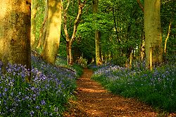
Grim's Ditch
Encyclopedia
Earthworks (archaeology)
In archaeology, earthwork is a general term to describe artificial changes in land level. Earthworks are often known colloquially as 'lumps and bumps'. Earthworks can themselves be archaeological features or they can show features beneath the surface...
. Enigmatic in both their naming and original function, examples are found across the chalk uplands of southern England
England
England is a country that is part of the United Kingdom. It shares land borders with Scotland to the north and Wales to the west; the Irish Sea is to the north west, the Celtic Sea to the south west, with the North Sea to the east and the English Channel to the south separating it from continental...
.
Purpose and etymology
The purpose of these earthworks remains a mystery, but as they are too small for military use they may have served to demarcate territory. Archaeologists agree that Iron Age peoples built the earthworks around 300 BC300 BC
Year 300 BC was a year of the pre-Julian Roman calendar. At the time it was known as the Year of the Consulship of Corvus and Pansa...
. Today, Grim's Ditch forms a section of The Ridgeway National Trail, a long distance path and one of the 15 National Trails in England and Wales.
The name "Grim's Ditch" is Old English in origin, and originates from Grim, one of the many names for the Anglo-Saxon god Woden (called Odin
Odin
Odin is a major god in Norse mythology and the ruler of Asgard. Homologous with the Anglo-Saxon "Wōden" and the Old High German "Wotan", the name is descended from Proto-Germanic "*Wodanaz" or "*Wōđanaz"....
by the Norse) and meaning "the masked one". Among Woden's many roles is that of a god of war, and it may be that the Anglo-Saxons perceived the earthworks as military in function and therefore ascribed them to him.
The name Graham's Dyke (an alternative name for the Antonine Wall
Antonine Wall
The Antonine Wall is a stone and turf fortification built by the Romans across what is now the Central Belt of Scotland, between the Firth of Forth and the Firth of Clyde. Representing the northernmost frontier barrier of the Roman Empire, it spanned approximately 39 miles and was about ten feet ...
) is a variant of Grim's Dyke.
Berkshire
The West Berkshire ditch is a 5 miles (8 km) section on the Berkshire DownsBerkshire Downs
The Berkshire Downs are a range of chalk downland hills in southern England, part of the North Wessex Downs Area of Outstanding Natural Beauty...
, the chalk
Chalk
Chalk is a soft, white, porous sedimentary rock, a form of limestone composed of the mineral calcite. Calcite is calcium carbonate or CaCO3. It forms under reasonably deep marine conditions from the gradual accumulation of minute calcite plates shed from micro-organisms called coccolithophores....
escarpment
Escarpment
An escarpment is a steep slope or long cliff that occurs from erosion or faulting and separates two relatively level areas of differing elevations.-Description and variants:...
above the Oxfordshire
Oxfordshire
Oxfordshire is a county in the South East region of England, bordering on Warwickshire and Northamptonshire , Buckinghamshire , Berkshire , Wiltshire and Gloucestershire ....
villages of Ardington
Ardington
Ardington is a village and civil parish about east of Wantage in the Vale of White Horse. Ardington was part of Berkshire until the 1974 boundary changes transferred it to Oxfordshire....
, Hendred
East Hendred
East Hendred is a village and civil parish in the English county of Oxfordshire, about east of Wantage in the Vale of White Horse and a similar distance west of Didcot. In 1974 it was transferred from Berkshire....
and Chilton
Chilton, Oxfordshire
Chilton is a village and civil parish in the Vale of White Horse about southwest of Didcot. The parish was part of Berkshire until the 1974 local government boundary changes transferred the Vale of White Horse to Oxfordshire....
.
Hampshire
One HampshireHampshire
Hampshire is a county on the southern coast of England in the United Kingdom. The county town of Hampshire is Winchester, a historic cathedral city that was once the capital of England. Hampshire is notable for housing the original birthplaces of the Royal Navy, British Army, and Royal Air Force...
ditch encloses an area of 16 square miles (41.4 km²) on the Wiltshire
Wiltshire
Wiltshire is a ceremonial county in South West England. It is landlocked and borders the counties of Dorset, Somerset, Hampshire, Gloucestershire, Oxfordshire and Berkshire. It contains the unitary authority of Swindon and covers...
and Dorset
Dorset
Dorset , is a county in South West England on the English Channel coast. The county town is Dorchester which is situated in the south. The Hampshire towns of Bournemouth and Christchurch joined the county with the reorganisation of local government in 1974...
borders. The earthwork runs for about 14 miles (22.5 km), and is a double-banked structure with a ditch between the banks. The Royal Commission's survey of Bokerley Dyke
Bokerley Dyke
Bokerley Dyke is a Romano-British defensive ditch in north east Dorset, England, near the villages of Woodyates and Pentridge. The ditch ran for several miles, cutting across the Roman Road between Old Sarum and Badbury Rings on the Cranborne Chase ridgeway. Dated to 367 CE, it was constructed to...
disputed the idea of Grim's Ditch being a single monument, and suggested it was in at least three parts. English Heritage's monument scheduling suggests that Grim's Ditch may be of Bronze Age
Bronze Age
The Bronze Age is a period characterized by the use of copper and its alloy bronze as the chief hard materials in the manufacture of some implements and weapons. Chronologically, it stands between the Stone Age and Iron Age...
or Early Iron Age date.
Another can be found in west Hampshire, mid-way between the villages of Upton
Upton
Upton is the name of a number of people and places. It may refer to:-Places:In Canada*Upton, QuebecIn England*Upton, Berkshire*Upton, Buckinghamshire*Upton, Cambridgeshire*Upton, Cornwall*Upton, Cumbria*Upton, Dorset*Upton, Hampshire...
and Netherton
Netherton
-England:*Netherton, Peterborough, *Netherton, Cheshire*Netherton, Devon*Netherton, Hampshire*Netherton, Herefordshire*Netherton, Merseyside*Netherton, Northumberland*Netherton, Oxfordshire*Netherton, West Midlands...
.
South Oxfordshire
The South Oxfordshire ditch is a 5 miles (8 km) section between MongewellMongewell
Mongewell is a village in the civil parish of Crowmarsh, about south of Wallingford in Oxfordshire. Mongewell is on the east bank of the Thames, linked with the west bank at Winterbrook by the nearby Winterbrook Bridge...
, on the banks of the Thames near Wallingford and Hayden Farm near Nettlebed
Nettlebed
Nettlebed is a village in England in the Chiltern Hills about northwest of Henley-on-Thames in Oxfordshire and southeast of Wallingford.-History:Archaeological finds show that the area around Nettlebed has been inhabited since Palaeolithic times....
in the Chilterns escarpment. Part of the western end was excavated during the building of Winterbrook Bridge, and dated as late Iron Age
Iron Age
The Iron Age is the archaeological period generally occurring after the Bronze Age, marked by the prevalent use of iron. The early period of the age is characterized by the widespread use of iron or steel. The adoption of such material coincided with other changes in society, including differing...
/early Roman
Roman Britain
Roman Britain was the part of the island of Great Britain controlled by the Roman Empire from AD 43 until ca. AD 410.The Romans referred to the imperial province as Britannia, which eventually comprised all of the island of Great Britain south of the fluid frontier with Caledonia...
. The ditch has a bank on the north side which suggests that its function was to exclude passage into the southernmost part of Oxfordshire.
Chilterns
The Chilterns ditch starts at BradenhamBradenham, Buckinghamshire
Bradenham is a village and civil parish within Wycombe district in Buckinghamshire, England. It is near Saunderton, off the main A4010 road between Princes Risborough and High Wycombe.- Village :...
, further north in the Chilterns than the end of the South Oxfordshire ditch. There are separate sections extending some 30km north to Ivinghoe
Ivinghoe
Ivinghoe is a village and civil parish within Aylesbury Vale district in Buckinghamshire, England, close to the border with Hertfordshire and Bedfordshire. It is four miles north of Tring and six miles south of Leighton Buzzard, close to the village of Pitstone.The village name is Anglo-Saxon in...
, partly along the Chiltern escarpment. Its size varies considerably. Its purpose is uncertain, and different sections may have had different functions.
Harrow
Grim's Ditch (also known as Grim's Dyke) on Harrow WealdHarrow Weald
Harrow Weald is an area in north-west London, England. It includes a suburban development and forms part of the London Borough of Harrow.-Locale, geography and history:...
Common at the north western edge of Greater London
Greater London
Greater London is the top-level administrative division of England covering London. It was created in 1965 and spans the City of London, including Middle Temple and Inner Temple, and the 32 London boroughs. This territory is coterminate with the London Government Office Region and the London...
extends for some 3 km although it was once longer. The nearby house called Grim's Dyke
Grim's Dyke
Grim's Dyke is the name of a house and estate located in Harrow Weald, in Northwest London, England, built in 1872 by Norman Shaw, and named after the nearby pre-historic earthwork known as Grim's Ditch. The house is best known as the home of dramatist W.S. Gilbert, who lived there for the last...
, built in 1872, was once the home of W. S. Gilbert
W. S. Gilbert
Sir William Schwenck Gilbert was an English dramatist, librettist, poet and illustrator best known for his fourteen comic operas produced in collaboration with the composer Sir Arthur Sullivan, of which the most famous include H.M.S...
and is now operated as Grim's Dyke Hotel.
British National Grid references
| Western end | Eastern end | |
|---|---|---|
| West Hampshire Hampshire Hampshire is a county on the southern coast of England in the United Kingdom. The county town of Hampshire is Winchester, a historic cathedral city that was once the capital of England. Hampshire is notable for housing the original birthplaces of the Royal Navy, British Army, and Royal Air Force... |
||
| Bokerley Dyke Bokerley Dyke Bokerley Dyke is a Romano-British defensive ditch in north east Dorset, England, near the villages of Woodyates and Pentridge. The ditch ran for several miles, cutting across the Roman Road between Old Sarum and Badbury Rings on the Cranborne Chase ridgeway. Dated to 367 CE, it was constructed to... , Martin Martin, Hampshire Martin is a village and civil parish in the New Forest, Hampshire. The nearest town Fordingbridge is to the southeast, and the cathedral city of Salisbury is to the northeast.-Overview:... , Hampshire Hampshire Hampshire is a county on the southern coast of England in the United Kingdom. The county town of Hampshire is Winchester, a historic cathedral city that was once the capital of England. Hampshire is notable for housing the original birthplaces of the Royal Navy, British Army, and Royal Air Force... |
||
| 50.98349°N 1.98962°W | 51.0095294°N 1.79206°W | Grim's Ditch, Dorset and Hampshire |
| North Oxfordshire Oxfordshire Oxfordshire is a county in the South East region of England, bordering on Warwickshire and Northamptonshire , Buckinghamshire , Berkshire , Wiltshire and Gloucestershire .... |
||
| South Oxfordshire Oxfordshire Oxfordshire is a county in the South East region of England, bordering on Warwickshire and Northamptonshire , Buckinghamshire , Berkshire , Wiltshire and Gloucestershire .... |
||
| West Berkshire West Berkshire West Berkshire is a local government district in the ceremonial county of Berkshire, England, governed by a unitary authority . Its administrative capital is Newbury, located almost equidistantly between Bristol and London.-Geography:... |
||
| Chilterns Grim's Ditch (Chilterns) Grim's Ditch is a series of linear earthwork in the Chilterns . A complete outline can not be identified but separate sections exist over a 30 km span between Bradenham, Buckinghamshire, Berkhamsted, Hertfordshire and as far as Pitstone and Ivinghoe Buckinghamshire... |
||
| Harrow Grim's Ditch (Harrow) Grim's Ditch or Grim's Dyke or Grimes Dike is an area of countryside in the London Borough of Harrow, close to the Hertfordshire borderline. It extends about two miles from Bushey Heath to Harrow and is most easily reached via Stanmore... |