

Government Center, Boston, Massachusetts
Encyclopedia
Government Center is an area in downtown Boston
, bounded by Cambridge, Court
, Congress
, and Sudbury Streets. Formerly the site of Scollay Square
, it is now the location of Boston City Hall
, two Suffolk County
courthouses, two state office buildings, and two federal office buildings, a major MBTA subway
interchange station, and City Hall Plaza
.
Boston City Hall
, built in the 1960s as part of Boston's first large Urban Renewal scheme. While considered by some to have architectural merit, the building is not universally admired, and is sharply unpopular among locals. Furthermore, it is resented for having replaced the Victorian architecture of Boston's Scollay Square, a lively commercial district that lapsed into squalor in the Twentieth Century.
The mayor has proposed moving City Hall to a new building (most recently in July 2008) elsewhere in the city and selling off the land. Some urban planners propose to bulldoze the complex and redevelop the area in the future.
, designed by architect Paul Rudolph
. The building is unfinished as the tall central tower in the original plan was never built. The adjacent space was filled with the Edward W. Brooke Courthouse
in the mid-1990s. This irregularly shaped, sloping lot was the last parcel to be developed of the Government Center urban renewal plan; in the interim the space was used as surface parking.
 Government Center is located between the North End and Beacon Hill
neighborhoods. It is directly across Congress Street from historic Faneuil Hall
and popular Quincy Market
and very near the Old State House
. It is two blocks away from Interstate 93
(the 'Big Dig') which runs through the historic bloodline of the city.
There has been a subway station here since the first subway in America was built in Boston in 1897. Initially named Scollay Square Station, it was made famous in 1959 when The Kingston Trio
performed a cover of a 1948 Boston protest song
, originally known as "Charlie On the MTA" but became a national hit as "M.T.A.," about a man who is trapped to ride on the subway forever due to exit fare
s, an unpopular fare-collection method that survived until 2007 on some MBTA extensions. Today the station, with its brick ziggurat
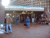
-shaped entrance is known as Government Center Station
and is the interchange for the Blue
and Green
Lines.
Several major city streets either surround or lead to the plaza, including Tremont
, Congress, Cambridge, Beacon
, State, Washington, and Devonshire Streets. Hints of another street, Cornhill
, still exist along one edge of City Hall Plaza—one of the few remaining old buildings (Sears Crescent) facing the square follows the original curve of the street, and one Cornhill Street address is still in use by a veteran's shelter.
History of the site
Boston
Boston is the capital of and largest city in Massachusetts, and is one of the oldest cities in the United States. The largest city in New England, Boston is regarded as the unofficial "Capital of New England" for its economic and cultural impact on the entire New England region. The city proper had...
, bounded by Cambridge, Court
Court Street (Boston, Massachusetts)
Court Street is located in the Financial District of Boston, Massachusetts. Prior to 1788, it was called Prison Lane and then Queen Street . In the 19th century it extended beyond its current length, to Bowdoin Square. In the 1960s most of Court Street was demolished to make way for the...
, Congress
Congress Street (Boston)
Congress Street in Boston, Massachusetts is located in the Financial District and South Boston. It was first named in 1800. It was extended in 1854 as far as Atlantic Avenue, and in 1874 across Fort Point Channel into South Boston...
, and Sudbury Streets. Formerly the site of Scollay Square
Scollay Square
Scollay Square was a vibrant city square in downtown Boston, Massachusetts. It was named for William Scollay, a prominent local developer and militia officer who bought a landmark four-story merchant building at the intersection of Cambridge and Court Streets in 1795...
, it is now the location of Boston City Hall
Boston City Hall
Boston City Hall is the seat of the municipal government of Boston, Massachusetts. Architecturally, it is an example of the brutalist style. It was designed by Kallmann McKinnell & Knowles...
, two Suffolk County
Suffolk County, Massachusetts
Suffolk County has no land border with Plymouth County to its southeast, but the two counties share a water boundary in the middle of Massachusetts Bay.-National protected areas:*Boston African American National Historic Site...
courthouses, two state office buildings, and two federal office buildings, a major MBTA subway
Rapid transit
A rapid transit, underground, subway, elevated railway, metro or metropolitan railway system is an electric passenger railway in an urban area with a high capacity and frequency, and grade separation from other traffic. Rapid transit systems are typically located either in underground tunnels or on...
interchange station, and City Hall Plaza
City Hall Plaza (Boston)
City Hall Plaza in Boston, Massachusetts, is a large, open, unadorned public space in the Government Center area of the city. The architectural firm Kallmann McKinnell & Knowles designed the plaza in 1962 to accompany Boston's new City Hall. The multi-level, irregularly-shaped plaza consists of red...
.
Boston City Hall
The dominant feature of Government Center is the enormous, imposing and brutalistBrutalist architecture
Brutalist architecture is a style of architecture which flourished from the 1950s to the mid 1970s, spawned from the modernist architectural movement.-The term "brutalism":...
Boston City Hall
Boston City Hall
Boston City Hall is the seat of the municipal government of Boston, Massachusetts. Architecturally, it is an example of the brutalist style. It was designed by Kallmann McKinnell & Knowles...
, built in the 1960s as part of Boston's first large Urban Renewal scheme. While considered by some to have architectural merit, the building is not universally admired, and is sharply unpopular among locals. Furthermore, it is resented for having replaced the Victorian architecture of Boston's Scollay Square, a lively commercial district that lapsed into squalor in the Twentieth Century.
The mayor has proposed moving City Hall to a new building (most recently in July 2008) elsewhere in the city and selling off the land. Some urban planners propose to bulldoze the complex and redevelop the area in the future.
City Hall Plaza
City Hall Plaza is not a well-loved space, either. As Bill Wasik wrote in 2006, "It is as if the space were calibrated to render futile any gathering, large or small, attempted anywhere on its arid expanse. All the nearby buildings seem to be facing away, making the plaza's 11 acres (44,515.5 m²) of concrete and brick feel like the world's largest back alley. … [It is] so devoid of benches, greenery, and other signposts of human hospitality that even on the loveliest fall weekend, when the Common and Esplanade and other public spaces teem with Bostonians at leisure, the plaza stands utterly empty save for the occasional skateboarder…" (Wasik 2006, 61) The plaza is often colloquially referred to as "the brick desert."Government Service Center
Another very large Brutalist building at Government Center, less prominently located and thus less well known than City Hall, is the Government Service CenterGovernment Service Center (Boston)
The Government Service Center is an unfinished, controversial, and neglected brutalist structure by architect Paul Rudolph. It is one of the major buildings in the Government Center complex in downtown Boston, Massachusetts, at Cambridge, Staniford and New Chardon Streets.- Function :The building...
, designed by architect Paul Rudolph
Paul Rudolph (architect)
Paul Marvin Rudolph was an American architect and the dean of the Yale School of Architecture for six years, known for use of concrete and highly complex floor plans...
. The building is unfinished as the tall central tower in the original plan was never built. The adjacent space was filled with the Edward W. Brooke Courthouse
Courthouse
A courthouse is a building that is home to a local court of law and often the regional county government as well, although this is not the case in some larger cities. The term is common in North America. In most other English speaking countries, buildings which house courts of law are simply...
in the mid-1990s. This irregularly shaped, sloping lot was the last parcel to be developed of the Government Center urban renewal plan; in the interim the space was used as surface parking.
Geography and transportation
Beacon Hill, Boston, Massachusetts
Beacon Hill is a historic neighborhood of Boston, Massachusetts, that along with the neighboring Back Bay is home to about 26,000 people. It is a neighborhood of Federal-style rowhouses and is known for its narrow, gas-lit streets and brick sidewalks...
neighborhoods. It is directly across Congress Street from historic Faneuil Hall
Faneuil Hall
Faneuil Hall , located near the waterfront and today's Government Center, in Boston, Massachusetts, has been a marketplace and a meeting hall since 1742. It was the site of several speeches by Samuel Adams, James Otis, and others encouraging independence from Great Britain, and is now part of...
and popular Quincy Market
Quincy Market
Quincy Market is a historic building near Faneuil Hall in downtown Boston, Massachusetts. It was constructed 1824–1826 and named in honor of Mayor Josiah Quincy, who organized its construction without any tax or debt.-History:...
and very near the Old State House
Old State House (Boston)
The Old State House is a historic government building located at the intersection of Washington and State Streets in Boston, Massachusetts, USA. Built in 1713, it is the oldest surviving public building in Boston, and the seat of the state's legislature until 1798. It is now a history museum...
. It is two blocks away from Interstate 93
Interstate 93
Interstate 93 is an Interstate Highway in the New England section of the United States. Its southern terminus is in Canton, Massachusetts, in the Boston metropolitan area, at Interstate 95; its northern terminus is near St. Johnsbury, Vermont, at Interstate 91...
(the 'Big Dig') which runs through the historic bloodline of the city.
There has been a subway station here since the first subway in America was built in Boston in 1897. Initially named Scollay Square Station, it was made famous in 1959 when The Kingston Trio
The Kingston Trio
The Kingston Trio is an American folk and pop music group that helped launch the folk revival of the late 1950s to late 1960s. The group started as a San Francisco Bay Area nightclub act with an original lineup of Dave Guard, Bob Shane, and Nick Reynolds...
performed a cover of a 1948 Boston protest song
Protest song
A protest song is a song which is associated with a movement for social change and hence part of the broader category of topical songs . It may be folk, classical, or commercial in genre...
, originally known as "Charlie On the MTA" but became a national hit as "M.T.A.," about a man who is trapped to ride on the subway forever due to exit fare
Exit fare
An exit fare is a method of collecting ridership fees, or fare, from a transportation system where the fee is collected from passengers upon reaching their destination....
s, an unpopular fare-collection method that survived until 2007 on some MBTA extensions. Today the station, with its brick ziggurat
Ziggurat
Ziggurats were massive structures built in the ancient Mesopotamian valley and western Iranian plateau, having the form of a terraced step pyramid of successively receding stories or levels.Notable ziggurats include the Great Ziggurat of Ur near Nasiriyah, Iraq; the Ziggurat of Aqar Quf near...
-shaped entrance is known as Government Center Station
Government Center (MBTA station)
Government Center is an MBTA subway station and a transfer point between the Green Line and the Blue Line. It is located at the intersection of Tremont, Court and Cambridge Streets in the Government Center area of Boston.-History:...
and is the interchange for the Blue
Blue Line (MBTA)
The Blue Line is one of four subway lines of the Massachusetts Bay Transportation Authority serving Downtown, East Boston and the North Shore. It runs from northeast to southwest, extending from Wonderland station in Revere, Massachusetts to Bowdoin station near Beacon Hill in Boston...
and Green
Green Line (MBTA)
The Green Line is a streetcar system run by the Massachusetts Bay Transportation Authority in the Boston, Massachusetts area of the United States. It is the oldest line of Boston's subway, which is known locally as the 'T'. The Green Line runs underground downtown and on the surface in outlying...
Lines.
Several major city streets either surround or lead to the plaza, including Tremont
Tremont Street
Tremont Street is a major thoroughfare in Boston, Massachusetts.-Etymology:The name is a variation of one of the original appellations of the city, "Trimountaine," a reference to a hill that formerly had three peaks. Beacon Hill, with its single peak, is all that remains of the Trimountain...
, Congress, Cambridge, Beacon
Beacon Street
Beacon Street is a major thoroughfare in Boston, Massachusetts and several of its western suburbs. Beacon Street in Boston, Brookline, Brighton, and Newton is not to be confused with the Beacon Street in nearby Somerville, or others elsewhere.-Description:...
, State, Washington, and Devonshire Streets. Hints of another street, Cornhill
Cornhill, Boston
Cornhill was a street in Boston, Massachusetts, in the 19th-20th centuries, located on the site of the current City Hall Plaza in Government Center. It was named in 1829; previously it was known as Market Street . In its time, it comprised a busy part of the city near Brattle Street, Court Street...
, still exist along one edge of City Hall Plaza—one of the few remaining old buildings (Sears Crescent) facing the square follows the original curve of the street, and one Cornhill Street address is still in use by a veteran's shelter.
See also
- Boston City HallBoston City HallBoston City Hall is the seat of the municipal government of Boston, Massachusetts. Architecturally, it is an example of the brutalist style. It was designed by Kallmann McKinnell & Knowles...
- Boston Housing CourtBoston Housing CourtThe Boston Housing Court is located in the Edward W. Brooke Courthouse, 24 New Chardon Street, Boston, Massachusetts. The court was established by the state legislature in 1971 and started its operation in August 1972. It handles summary proceedings for possession of land.-External links:* * * *...
- City Hall Plaza (Boston)City Hall Plaza (Boston)City Hall Plaza in Boston, Massachusetts, is a large, open, unadorned public space in the Government Center area of the city. The architectural firm Kallmann McKinnell & Knowles designed the plaza in 1962 to accompany Boston's new City Hall. The multi-level, irregularly-shaped plaza consists of red...
- Congress Street (Boston)Congress Street (Boston)Congress Street in Boston, Massachusetts is located in the Financial District and South Boston. It was first named in 1800. It was extended in 1854 as far as Atlantic Avenue, and in 1874 across Fort Point Channel into South Boston...
- Government Center (MBTA station)Government Center (MBTA station)Government Center is an MBTA subway station and a transfer point between the Green Line and the Blue Line. It is located at the intersection of Tremont, Court and Cambridge Streets in the Government Center area of Boston.-History:...
- Government Service Center (Boston)Government Service Center (Boston)The Government Service Center is an unfinished, controversial, and neglected brutalist structure by architect Paul Rudolph. It is one of the major buildings in the Government Center complex in downtown Boston, Massachusetts, at Cambridge, Staniford and New Chardon Streets.- Function :The building...
- John F. Kennedy Federal BuildingJohn F. Kennedy Federal BuildingJohn Fitzgerald Kennedy Federal Building is a United States Federal government office building located in the Government Center area of Boston, Massachusetts. It is adjacent to City Hall Plaza and is located diagonally across from Boston City Hall. The firm of Walter Gropius designed the building,...
- Massachusetts Appeals CourtMassachusetts Appeals CourtThe Massachusetts Appeals Court is the intermediate appellate court of Massachusetts. It was created in 1972 as a court of general appellate jurisdiction...
- Massachusetts Appellate Tax BoardMassachusetts Appellate Tax BoardThe Massachusetts Appellate Tax Board is a quasi-judicial agency within the Commonwealth of Massachusetts' Office of the Governor. Though part of the executive branch, the ATB is "not subject to its control in the conduct of its adjudicatory functions." G.L. c. 58A, 1...
- Massachusetts Supreme Judicial CourtMassachusetts Supreme Judicial CourtThe Massachusetts Supreme Judicial Court is the highest court in the Commonwealth of Massachusetts. The SJC has the distinction of being the oldest continuously functioning appellate court in the Western Hemisphere.-History:...
- New Chardon Street (Boston)New Chardon Street (Boston)New Chardon Street is a street in downtown Boston, Massachusetts, USA, north of Government Center. It begins at Cambridge Street at Bowdoin Square, across from Bowdoin Street. The two-way street continues east across Congress Street, ending at Haymarket Square with access to the Sumner and Callahan...
- Saltonstall BuildingSaltonstall BuildingThe Leverett Saltonstall Building is a high-rise building located in the Government Center district of Boston, Massachusetts. The building stands at 396 feet with 22 floors, and was completed in 1971. It is tied with One Devonshire Place and Harbor Towers II as the 28th-tallest building in Boston....
- Sears' Crescent and Sears' BlockSears' Crescent and Sears' BlockSears' Crescent and Sears' Block is an historic building at 38-68 and 70-72 Cornhill in Boston, Massachusetts. It is adjacent to City Hall and City Hall Plaza, Government Center, Boston.Sears' Crescent was constructed in 1816, and Sears Block in 1848...
- Social Law LibrarySocial Law LibraryThe Social Law Library, founded in 1804, is one of the oldest law libraries in the United States. It is located in the John Adams Courthouse at Pemberton Square in Boston, Massachusetts, the same building which houses the Massachusetts Supreme Judicial Court and the Massachusetts Appeals...
- Suffolk County CourthouseSuffolk County CourthouseThe Suffolk County Courthouse, also known as the "John Adams Courthouse", is a historic courthouse building on Pemberton Square in Boston, Massachusetts that is home to the Massachusetts Supreme Judicial Court....
- Thomas P. O'Neill Jr. Federal BuildingThomas P. O'Neill Jr. Federal BuildingThe Thomas P. "Tip" O'Neill Federal Building is an administrative center of the U.S. federal government in Boston, Massachusetts. Named for former Massachusetts congressman and House of Representatives Speaker Tip O'Neill, the building houses the New England regional offices of numerous federal...
History of the site
- Brattle Street (Boston, Massachusetts)Brattle Street (Boston, Massachusetts)Brattle Street was a street in Boston, Massachusetts located on the current site of City Hall Plaza, at Government Center.-History:Around 1853 former Virginia slave Anthony Burns worked for "Coffin Pitts, clothing dealer, no.36 Brattle Street."...
- Court Street (Boston, Massachusetts)Court Street (Boston, Massachusetts)Court Street is located in the Financial District of Boston, Massachusetts. Prior to 1788, it was called Prison Lane and then Queen Street . In the 19th century it extended beyond its current length, to Bowdoin Square. In the 1960s most of Court Street was demolished to make way for the...
- Hanover Street (Boston, Massachusetts)Hanover Street (Boston, Massachusetts)Hanover Street is located in the North End of Boston, Massachusetts. Prior to 1708, part of the street was called Orange Tree Lane. In 1824, North Street and the former Middle Street became part of Hanover...
- Edward J. LogueEdward J. LogueEdward J. "Ed" Logue was an urban planner, public administrator, lawyer, politician, and academic who worked in New Haven, Boston, and New York State....
- Scollay SquareScollay SquareScollay Square was a vibrant city square in downtown Boston, Massachusetts. It was named for William Scollay, a prominent local developer and militia officer who bought a landmark four-story merchant building at the intersection of Cambridge and Court Streets in 1795...
Further reading
- Sarah Schweitzer. In praise of ugly buildings. Boston Globe, January 24, 2010.
- Casey Ross. Ambitious plan for Government Center Garage site: Vast project calls for shops, housing. Boston Globe, June 23, 2011
External links
- Google news archive
- Google blog search
- "i: six nonlectures" by e.e. cummings, footnote
- Sophie and the Suburbs, Jewish Week, Sept. 27 2002
- (http://www.tsomides.com/news/downloads/EditorCityHallPlaza2.pdf)
- http://www.flickr.com/photos/arthurohm/sets/72157623853538550
- http://www.flickr.com/photos/gigharmon/sets/72157606318827540