
.gif)
Green Line (MBTA)
Encyclopedia
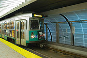
The Green Line is a streetcar system run by the Massachusetts Bay Transportation Authority
(MBTA) in the Boston, Massachusetts
area of the United States
. It is the oldest line of Boston's subway
, which is known locally as the 'T'. The Green Line runs underground downtown and on the surface in outlying areas. With a daily weekday ridership of 241,100, it is also the most heavily-used light rail line in the country. The line was given the green color because it goes primarily though an area called the Emerald Necklace
of Boston. The four branches are the remnants of a once large system of streetcar lines, begun in 1856 with the Cambridge Horse Railroad. The Tremont Street Subway
carries cars of all branches under downtown, and is the oldest subway tunnel in North America
, opened in stages between September 1, 1897, and September 3, 1898, to take streetcars off surface streets.
 The modern-day Green Line has its northern terminus at Lechmere
station in eastern Cambridge
. From there it runs south in the Tremont Street Subway
under downtown Boston, then west in the Boylston Street Subway to Kenmore
. Collectively, the Green Line tunnels through Downtown Boston and the Back Bay are sometimes called the Central Subway in planning documents. Along the way, the "E" Branch splits just west of Copley
station, running southwest through the Huntington Avenue Subway, eventually ramping up to the surface, continuing along Huntington Avenue, and terminating at Heath Street
.
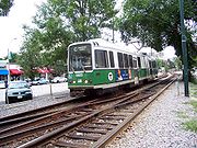
The "B", "C", and "D" Branches all diverge west of Kenmore. From south to north, the "D" Branch surfaces onto the grade-separated Highland Branch, a branch of the Boston and Albany Railroad
until 1958, running to Riverside
. The "C" Branch surfaces onto Beacon Street, running to Cleveland Circle, and the "B" Branch runs along Commonwealth Avenue to Boston College
.
The "A" Branch ran to Watertown
until 1969. Although the route-letter scheme had been introduced two years prior to its closure, the "A" designation was never signed on streetcars operating to Watertown. It was, however, included in the destination sign
s on the Boeing-Vertol LRV
s ordered in the mid-1970s, when reopening the Watertown service was still under consideration. The A line tracks remained in non-revenue service to access maintenance facilities at Watertown until 1994.
The elevated tracks north of the Central Subway near North Station were closed from June 2004 until November 12, 2005 for replacement of the Causeway Street Elevated
with a new tunnel under Causeway Street, still connecting to the Lechmere Viaduct
. The historic concrete
Viaduct across the Charles River
remains in service, although it was closed for a number of months in 2011 to allow a complete rebuilding of Science Park
station.
The original Tremont Street Subway south of Boylston
station has been closed since 1962, and the streetcar lines feeding into it were replaced by bus service. The Pleasant Street Portal at its southern end has been covered over, but there were plans to build a new portal and reuse part of the tunnel for Phase III of the Silver Line
bus rapid transit
project. As of 2011, all Phase III tunnel construction plans are on indefinite hold, due to lack of funding, and heavy community opposition.
 Like the three other MBTA subway lines, the Green Line uses standard gauge
tracks.
At the end of the 19th century, the original purpose of the Tremont Street Subway
was to allow ordinary streetcars to bypass the worst street congestion in crowded sections of downtown Boston. Thus, ordinary street cars were the first rolling stock used on what would later be designated the Green Line.
For many years, the Green Line used the PCC streetcar
s developed during the Depression
. These were finally phased out in favor of the US Standard Light Rail Vehicle
supplied by the new US venture Boeing-Vertol
in the mid-1970s. The introduction of the LRV cars was initially heralded as part of an effort to rejuvenate mass transit in medium-sized metropolises. This first series of LRVs were subject to chronic breakdowns, and Boeing soon abandoned its venture into ground transit vehicles.
Desperate for reliable rolling stock, the MBTA launched a PCC overhaul program to extend their life, and these classic cars were still used into the 1980s in the Central Subway. As of 2011, several of the surviving PCC cars are still run on the Ashmont-Mattapan
portion of the Red Line
.
In 1987, 100 second generation LRVs were ordered from the Japanese firm Kinki Sharyo
, with an additional set of 20 cars ordered and delivered in 1997. The last of the Boeing-Vertol cars were retired in March, 2007, and almost all of them were scrapped. As of 2011, the Kinki Sharyo cars now make up the bulk of the Green Line's rolling stock, plus the newer "Breda" cars, as described under the "Accessibility" section of this article.
One of the earliest surviving pre-PCC cars, Type 5 5734, can still be seen parked on a sidetrack at the Boylston station, along with PCC 3295. These two cars used to be in working condition and were frequently used for fantrips. The most recent fantrip was in 1997, and now the railcars sit at Boylston collecting dust. It is highly doubtful that these cars are still in working condition, and Type 5 5734 reportedly has structural problems with the roof. The San Francisco
Muni
F Market
line historic street railway runs a PCC car in Boston colors, but that specific car never actually ran in Boston.
, Blue Line
, and Orange Line
, all of which run rapid transit
cars and use stations with elevated platforms
(so that the car floor is level with the platform and thus the cars are easily handicap-accessible), the Green Line is a trolley
/streetcar line and has used a variety of trolley cars and light rail
vehicles throughout its history.
Originally, none of the Green Line stations included elevated or raised platforms, and the passengers had to ascend several steps up into the vehicles, limiting accessibility for persons with disabilities. To address this, two changes have been made:
 One hundred low-floor cars were purchased from the Italian
vendor AnsaldoBreda (Breda), with styling by Pininfarina
. These cars initially proved to be problematic and difficult to maintain. The first cars delivered failed every 400 miles (640 km), far less than the 9,000 miles (14,500 km) specified by the MBTA, and were prone to derailments. The MBTA has been forced to spend an additional US$
9.5 million to modify tracks to prevent the derailment problems, echoing early problems with the Boeing stock. The MBTA has been criticized for their failure to assess Breda's reliability before entering into the deal, and during the delivery of the vehicles.
In December 2004, the MBTA canceled orders for the remaining cars still to be delivered as part of the authority's nine-year, US$225 million-dollar deal with Breda. One year later, in December 2005 the MBTA announced that it had entered into a restructuring of the deal with the Italian vendor, reducing the order to 85 cars (with spare parts to be provided in lieu of the 15 remaining cars), and providing for the remaining payment under the original 1995 deal only if the cars meet performance requirements. Construction of the last car under the order was completed on December 14, 2006; though in late 2007 the MBTA announced it had contracted with Breda to deliver another 10 cars, bringing the total order to 95 production cars and 5 car shells for parts. As of June 2008, 90 of the Type 8 cars were in service; one was damaged in a derailment/fire incident, and four are still in testing.
After several years of modifications to the Green Line "D" Branch tracks, the Breda cars finally returned to service on that line, and now provide service to every branch of the Green Line.
The MBTA runs one-, two-, and, rarely, three-car trains on the Green Line, depending on travel demand and vehicle availability. As of January 14, 2009, two-car trains now run from the start to end of service Monday through Friday, with the promise that three-car trains will be in service after conclusion of station reconstruction on the Central Subway to make it ADA compliant. The MBTA has promised that each two-car train on the system will contain at least one Type 8 low-platform car to facilitate access for disabled persons.
The name "Green Line" was assigned in the 1960s as part of a major reorganization of the MBTA system's branding.
The predecessor of today's Green Line was created by the Massachusetts legislature, but under private ownership, as the West End Street Railway in 1887. This system of horse-drawn streetcars was the merger of numerous independently operated railways built from the 1850s onward. At the time of the merger, West End operated 1,480 cars with a team of 7,816 horses.
The Allston - Park Square line (which served the general area of the "A" Branch, and is covered in that article) was the first section to be converted to electric traction in 1889, using modified existing horsecars outfitted with Frank J. Sprague
's equipment first demonstrated in Richmond, Virginia
. This initial line used overhead trolley wire
s for most of its length, but also third rail
equipment supplied by the Bentley-Knight Electric Railway Company in sections where residents initially objected to overhead lines. The Bentley-Knight approach was abandoned soon after several horses were electrocuted due to inadequate insulation. By 1889, the Sprague equipment was dropped in favor of Thomson-Houston (now General Electric
) motors
and generators
, to which the rest of the system was converted.
In 1897, the West End Street Railway property was handed over to the Boston Elevated Railway
(BERy) in the form of a 24 year lease, and the companies were ultimately combined. BERy, now under state ownership, evolved into today's MBTA, which was called the Metropolitan Transit Authority (MTA) in the interim from 1947 to 1964.
As a tunnel built to get streetcar lines off the streets, rather than a rapid transit
line, the Tremont Street Subway has had many connecting surface branches, with many services operating in many patterns. Additionally, many services from other companies, notably the Eastern Massachusetts Street Railway
and its predecessors, have run into the subway from outer suburb
an points via BERy trackage. A partial list of these services is in the green rows on Boston-area streetcar lines
.
In the 1970s the Green Line and all other MBTA lines were re-evaluated by the Boston Transportation Planning Review for region-wide efficacy and future modernization alternatives initiated as far as physical plant and operating measures.
is the north end of the Green Line. From the opening of the Lechmere Viaduct
leading to it in 1912 until 1922, streetcar lines simply fed onto the viaduct from Cambridge Street and Bridge Street (now Monsignor O'Brien Highway). In 1922 a prepayment station was opened, with a new loop for subway trains to turn around and a separate loop for surface cars, and no intermingling between the two. The surface lines have since been replaced with bus
es, but the Green Line still turns around at Lechmere.
 The Canal Street Portal (also Haymarket Portal, North Station Portal or Causeway Street Portal, often referred to in revenue service as the Canal Street Loop) was part of the transition between subway and elevated railway
on the Green Line, as it transitioned from the Tremont Street Subway
to the Causeway Street Elevated
towards the Lechmere Viaduct
until 2004, when the Green Line north of North Station was closed for building of a new tunnel and portal. Certain trains turned at Canal Street, while others emerged from the subway to a viaduct to Lechmere. It was, however, possible for a passenger to alight from a train at Canal Street and proceed up a series of stairways to the Lechmere Viaduct. However most passengers desiring to continue to Science Park or Lechmere would have changed to a Lechmere signed car from a North Station signed car prior to the emergence from the central subway.
The original four-track portal opened in 1898 at the north end of the first subway; cars could turn east or west on Causeway Street. In 1901 the Charlestown Elevated
was connected to the outer tracks, and streetcars only operated via the inner tracks. The Washington Street Tunnel opened in 1908, connecting to the Elevated via a new portal just east of the streetcar one, and all four tracks were once again open for streetcar use until 1975. In 1912 the Lechmere Viaduct opened, again using the two outer tracks for an elevated line. The inner tracks continued to serve the surface, including a surface station at North Station, until 1997, when they were closed for construction of the new tunnel and the Green Line was shifted to the old Orange Line (Charlestown Elevated) portal along the way. The was the last service to continue onto surface streets from the portal, last running in 1949.
 The Pleasant Street Portal was the south end of the Tremont Street Subway
, opened one month after the original subway in 1897. It split from the Boylston Street Subway at a flying junction
at Boylston
, and another flying junction split the tunnel into two side-by-side tunnels to the four-track portal. The two west tracks rose onto Tremont Street
and the two east ones onto Pleasant Street, later part of Broadway. From 1901 to 1908 the portal was only used by Washington Street Elevated
trains, after which streetcar service was restored—though much of it had been cut back to Dudley
for transfer to the Elevated. The last cars ran through the portal in 1961 as part of the , and in 1962 a shuttle service from Boylston to the portal was ended. The portal has since been covered.
, when the Huntington Avenue Subway opened as a branch off the main subway and the portal was closed.
at the end of the Huntington Avenue Subway, just east of Northeastern University
. It opened in 1941 and carries "E" Branch trains.
The incline was built as a wooden trestle to the street atop a level grade, as the original plans called for eventual extension of the subway; in the mid 1980s the trestle was replaced with fill (which greatly quieted the sound).
was built and two new portals opened to the west.
station. They are currently used by the "B" and "C" Branches respectively. The Fenway Portal opened in 1959 along with the opening of the Highland Branch, and provides a third exit from Kenmore, south of the St. Marys Street Portal. It carries trains of the "D" Branch.
Lechmere
is currently the north end of the Green Line, and consists of a balloon-shaped turnaround.
At North Station, trains heading eastbound/outbound toward Lechmere
can turn around. No turnaround is available in the westbound/inbound direction.
At Government Center
, trains entering from either the east or west can turn around.
At Park Street
trains can turn around in one direction only. Trains headed toward Lechmere
upon entering Park Street
on the inside track can turn around on a tight turn and end up on the so called fence track. This is the track that takes trains out to Boston College
and Heath Street
.
Kenmore
is where trains coming from Cleveland Circle or the Riverside Branch can turn around to the outbound track that takes trains to Cleveland Circle or Riverside. No turnaround is available for the "Boston College"/"Commonwealth Avenue" Branch.
The "B", "Boston College" or "Commonwealth Avenue" Branch is the northernmost of the three lines that split west of Kenmore. It travels west down the middle of Commonwealth Avenue, ending at Boston College
. , regular B service turns around at Government Center
. It is the most criticized line in the Green Line, primarily due to its high frequency of densely located stops. This causes the branch to bear the highest average per-mile operations cost, the slowest passenger riding time, and the greatest number of complaints.
The "C", "Cleveland Circle" or "Beacon Street" Branch is the middle one of the three branches heading west from Kenmore, and the straightest, running down the middle of Beacon Street through Brookline to Cleveland Circle. , regular "C" service turns around at North Station.
The "D" or "Highland" Branch is the southernmost of the three lines that separate west of Kenmore. It is the longest branch, ending in Newton at Riverside
. It is the most recent branch, opening in 1959 along the former right-of-way of the Highland Branch of the Boston and Albany Railroad
, and has full grade separation, entering the subway at the Fenway Portal. , regular "D" service turns around at Government Center
.
The "E" or "Arborway" Branch diverges from the other three lines just west of Copley. It travels mainly on the surface of Huntington Avenue
, emerging from the Huntington Avenue Subway at the Northeastern Portal. Since 1985, service has been truncated to Heath Street
, with continuing service to Arborway provided by the bus. In 2008, the tracks from Heath Street to Arborway were paved over. The "E" is the only branch to have a regularly used street-running section. , regular "E" service turns around at Lechmere
. Passengers must board "E" Branch trains to get to station stops between Lechmere
and North Station.
The Pleasant Street Portal hosted two services in its final days. The to City Point
ended in 1953, and the to Egleston was cut back to Lenox Street
in 1956, cut back to the portal in 1961, and ended operation in 1962. Prior to that, the ran out Tremont Street to [Dover Street and Washington Street
, ending at Dudley
, and last running in 1938.
The last two routes to continue beyond the Canal Street Portal both ran to Sullivan
. The ran via Main Street, last running in 1948, and the via Bunker Hill Street last ran in 1949. Until 1997 trains continued to use the portal and its North Station surface station as a terminal.
In addition to the lines that later became the "E" Branch, the predecessors to the and split in Brookline
, one branch running into the current "E" tracks and into the Boylston Street Portal, and the other running up Brookline Street to end at Massachusetts Avenue station. These were truncated in 1932 into a shorter route from Brookline Village
to the subway via the Boylston Street Portal, which itself stopped running in 1938 (being cut back to Brigham Circle
short-turn trips), three years before the closure of that portal.
The last "foreign" cars to operate in the subway were those of the Eastern Massachusetts Street Railway
, running from the Canal Street Portal to the Brattle Loop at Scollay Square
until 1935. It was then that the old Mystic River Bridge to Chelsea
was closed to streetcars and the lines were replaced by bus service; the next year the BERy bought the Eastern Mass Chelsea Division and through-routed it with its lines connecting to the East Boston Tunnel at Maverick
.
From the Lechmere
terminal opening on July 10, 1922 to February 6, 1931, special service ran from Lechmere to various points on the subway. These trips were replaced on February 7, 1931 by extensions of the various branches from the west, which had terminated at Park Street
, through to Lechmere.
The Green Line is monitored from the 45 High Street rapid transit control room. Responsibility for controlling service is shared by the control room and field personnel located along the right of way. Track circuit and signal indications are not transmitted to the operational personnel sites. In lieu of track circuit indications, the AVI system is displayed in the control room to provide a periodic update to train position wherever AVI detectors exist. The AVI system user interface was solely text based until the current control room was opened, in which a new schematic display based on AVI data was instituted. Track circuit indications are available digitally in three signal houses but not transmitted to central control—at Park Street interlocking, at the new North Station interlocking, and at the new Kenmore interlocking.
Plans to reinstitute a crossover for through movements from the terminating (inner) northbound platform at Park Street towards Government Center are expected to increase capacity on the Green Line.
to mitigate increased automobile emissions from the Big Dig, the Commonwealth of Massachusetts agreed to extend the Green Line from its present northern terminus at Lechmere
to Medford Hillside. The extension would pass through Somerville
and Medford
, two suburbs currently underserved by the MBTA relative to their population densities, commercial importance, and proximity to Boston. The line would use two railroad rights-of-way that currently serve the Lowell Line
(which also carries Amtrak
's Downeaster
) and the Fitchburg Line
MBTA Commuter Rail. The extension is projected to have a total weekday ridership of about 52,000. The Green Line would see an increase in boardings of 30,700, and the MBTA system would see between 7,000 and 8,000 new transit users.
As of February 2, 2009, the stops planned for the Green Line Extension would be a relocated Lechmere Station
, Brickbottom at Washington Street, Gilman Square at Medford Street, Lowell Street, Ball Square
, Hillside (at College Avenue in Medford, on the edge of Tufts University
campus), and a terminus at Route 16 and Mystic Valley Parkway in Somerville (on the Mystic River
). A potential stop at Winthrop Street and Boston Ave was dropped due to the proximity of other stations and neighborhood opposition. A branch line would split off after Lechmere station, ending at Union Square in Somerville (or slightly south thereof, on the Fitchburg Line
). The plan was designed to extend the Green Line to Mystic Valley Parkway by the settlement-imposed deadline of December 31, 2014.
Stops are designed to be accessible by pedestrians and bikes or drop-off, but with no new parking. The 2003 PMT estimated a cost of $375,000,000 for the Green Line Extension, a figure that presumed the Extension would reach West Medford (about 1500 feet (457.2 m) further than the current plan) with a daily ridership of 8,420 and 3,540 of those diverted from non-transit modes. At 10% design, the Final Environmental Impact Report estimated a cost of $953.7 million (in "year of expenditure" dollars) for seven new stations and 24 new light rail vehicles.
The MBTA plans to extend the E branch from Lechmere to Union Square, and extend the D branch from Government Center to College Avenue. The contract for construction would be a Design/Build construction contract. The contract was expected to be advertised for Design/Build Ventures to bid on in Fall 2011. Construction would begin in Spring 2012 with an expected cost of $953.7 Million. The project would be partially funded by the Commonwealth and the Federal Government under the New Starts Program.
In 2010, the Massachusetts Department of Transportation (MDOT) announced that the new service was expected to be operational in October 2015; interim air quality offset measures would need to be taken if the project misses its December 2014 deadline as expected. The Department of Transportation had previously announced that due to budget limitations, the portion from College Avenue to Route 16 would be a future second phase of the extension, not included in the current proposed project.
As of August 2011, MDOT has announced that opening of the Extension has been postponed to Fall 2018 at the earliest. Completion of the Extension to College Avenue near Tufts University could be delayed to 2020, while the terminus at Mystic Valley Parkway remains deferred indefinitely. The stated reason for the delays is difficulties in land acquisition, plus implied concerns about cost controls and financing.
and Arborway/Forest Hills
. After some internal and community opposition, a revised settlement agreement resulted in the substitution of other projects with similar air quality benefits. In lieu of the rail project, the state undertook a project to speed the Route 39 bus by making improvements such as consolidating bus stops, lengthening stops, and re-timing traffic lights. Improvements were funded by the federal American Recovery and Reinvestment Act of 2009
and were expected to be completed in 2010.
and Copley Square
stations are currently being rebuilt for reasons of accessibility. Arlington
station was recently rebuilt and is now wheelchair accessible, equipped with elevators, mobile lifts and raised platforms. As of 2011, the MBTA was planning a $72 million project to rebuild Government Center
station in Boston for ADA compliance.
(also called fare control), which allow quick boarding through front and rear doors at a train stop. At all other stations, passengers must line up at the front entrance to the railcar to pay fares, slowing travel times especially during peak periods.
. The operator of one of the trains was killed and numerous riders were taken to the hospital with injuries of varying degrees of seriousness. While it was originally thought that cell phone use was responsible for the accident, it was determined that the actual cause of the crash was an episode of micro-sleep caused by the driver's sleep apnea
.
On May 8, 2009, two Green Line trolleys rear-end collided underground between the Park Street Station
and Government Center Station
when the driver of one of the trolleys, 24-year-old Aiden Quinn, was text messaging his girlfriend while driving
the train. A tougher policy on cell phones by the MBTA was put in place. Quinn had run through a red light before the trolley crash. The crash injured 46 people. MBTA officials estimated that the cost of damages from the crash was $9.6 million.
A pilot test of collision-avoidance technology on the Ashmont–Mattapan High Speed Line is planned in 2009, which is intended to facilitate the adoption of similar technology on the Green Line.
Massachusetts Bay Transportation Authority
The Massachusetts Bay Transportation Authority, often referred to as the MBTA or simply The T, is the public operator of most bus, subway, commuter rail and ferry systems in the greater Boston, Massachusetts, area. Officially a "body politic and corporate, and a political subdivision" of the...
(MBTA) in the Boston, Massachusetts
Massachusetts
The Commonwealth of Massachusetts is a state in the New England region of the northeastern United States of America. It is bordered by Rhode Island and Connecticut to the south, New York to the west, and Vermont and New Hampshire to the north; at its east lies the Atlantic Ocean. As of the 2010...
area of the United States
United States
The United States of America is a federal constitutional republic comprising fifty states and a federal district...
. It is the oldest line of Boston's subway
Rapid transit
A rapid transit, underground, subway, elevated railway, metro or metropolitan railway system is an electric passenger railway in an urban area with a high capacity and frequency, and grade separation from other traffic. Rapid transit systems are typically located either in underground tunnels or on...
, which is known locally as the 'T'. The Green Line runs underground downtown and on the surface in outlying areas. With a daily weekday ridership of 241,100, it is also the most heavily-used light rail line in the country. The line was given the green color because it goes primarily though an area called the Emerald Necklace
Emerald Necklace
The Emerald Necklace consists of an chain of parks linked by parkways and waterways in Boston and Brookline, Massachusetts. It gets its name from the way the planned chain appears to hang from the "neck" of the Boston peninsula, although it was never fully constructed.-Overview:The Necklace...
of Boston. The four branches are the remnants of a once large system of streetcar lines, begun in 1856 with the Cambridge Horse Railroad. The Tremont Street Subway
Tremont Street Subway
The Tremont Street Subway is a tunnel in Boston's subway system, and is the oldest subway tunnel in North America, opening on September 1, 1897. It was originally built as a tunnel to get streetcar lines off the streets, rather than a rapid transit line...
carries cars of all branches under downtown, and is the oldest subway tunnel in North America
North America
North America is a continent wholly within the Northern Hemisphere and almost wholly within the Western Hemisphere. It is also considered a northern subcontinent of the Americas...
, opened in stages between September 1, 1897, and September 3, 1898, to take streetcars off surface streets.
Description
Lechmere (MBTA station)
Lechmere is the northern terminus of the MBTA Green Line. It is located in Lechmere Square in East Cambridge, Massachusetts, near the intersection of Cambridge Street and Monsignor O'Brien Highway . The tracks make a loop at Lechmere, with a small yard...
station in eastern Cambridge
Cambridge, Massachusetts
Cambridge is a city in Middlesex County, Massachusetts, United States, in the Greater Boston area. It was named in honor of the University of Cambridge in England, an important center of the Puritan theology embraced by the town's founders. Cambridge is home to two of the world's most prominent...
. From there it runs south in the Tremont Street Subway
Tremont Street Subway
The Tremont Street Subway is a tunnel in Boston's subway system, and is the oldest subway tunnel in North America, opening on September 1, 1897. It was originally built as a tunnel to get streetcar lines off the streets, rather than a rapid transit line...
under downtown Boston, then west in the Boylston Street Subway to Kenmore
Kenmore (MBTA station)
Kenmore is an MBTA light rail station in the Kenmore Square area of Boston, Massachusetts, and serves the Green Line B, C, and D branches...
. Collectively, the Green Line tunnels through Downtown Boston and the Back Bay are sometimes called the Central Subway in planning documents. Along the way, the "E" Branch splits just west of Copley
Copley (MBTA station)
Copley is a station on the MBTA Green Line light rail subway in Boston, Massachusetts. Located in and named after Copley Square, the station has entrances and exits along Boylston Street and Dartmouth Street....
station, running southwest through the Huntington Avenue Subway, eventually ramping up to the surface, continuing along Huntington Avenue, and terminating at Heath Street
Heath Street (MBTA station)
Heath Street, announced as Heath Street/VA Medical Center, is the last stop of the MBTA Green Line's E branch located along South Huntington Avenue on the Mission Hill/Jamaica Plain neighborhood line of Boston, Massachusetts...
.
The "B", "C", and "D" Branches all diverge west of Kenmore. From south to north, the "D" Branch surfaces onto the grade-separated Highland Branch, a branch of the Boston and Albany Railroad
Boston and Albany Railroad
The Boston and Albany Railroad was a railroad connecting Boston, Massachusetts to Albany, New York, later becoming part of the New York Central Railroad system, Conrail and CSX. The line is used by CSX for freight...
until 1958, running to Riverside
Riverside (MBTA station)
Riverside is the western terminus of the MBTA Green Line "D" Branch light rail line. It is located at 333 Grove Street, off Exit 22 on Interstate 95 , in Auburndale, a village of Newton, Massachusetts. Scheduled travel time to Park Street is 46 minutes. Riverside includes a parking...
. The "C" Branch surfaces onto Beacon Street, running to Cleveland Circle, and the "B" Branch runs along Commonwealth Avenue to Boston College
Boston College (MBTA station)
The Boston College station is the western terminus of the MBTA Green Line's B-branch . It is located at St Ignatius Square on the Boston College campus in Brighton, Massachusetts, near the intersection of Commonwealth Avenue and Lake Street.Originally called Lake Street, the station was once the...
.
The "A" Branch ran to Watertown
Watertown (MBTA station)
Watertown Square in Watertown, Massachusetts is the termination point of the Massachusetts Bay Transportation Authority's route 71 trackless trolley and the bus. Buses and pass through Watertown Square...
until 1969. Although the route-letter scheme had been introduced two years prior to its closure, the "A" designation was never signed on streetcars operating to Watertown. It was, however, included in the destination sign
Destination sign
A destination sign or destination indicator is a sign mounted on the front or side of a public transport vehicle, such as a bus, tram/streetcar or light rail vehicle, that displays the vehicle's route number and destination, or the route's number and name on transit systems using route names...
s on the Boeing-Vertol LRV
US Standard Light Rail Vehicle
The US Standard Light Rail Vehicle was an attempt at a standardized light rail vehicle promoted by the United States Urban Mass Transportation Administration and built by Boeing Vertol in the 1970s...
s ordered in the mid-1970s, when reopening the Watertown service was still under consideration. The A line tracks remained in non-revenue service to access maintenance facilities at Watertown until 1994.
The elevated tracks north of the Central Subway near North Station were closed from June 2004 until November 12, 2005 for replacement of the Causeway Street Elevated
Causeway Street Elevated
The Causeway Street Elevated was a part of the MBTA's Green Line in Boston, Massachusetts that ran roughly northwards from Haymarket, then ran westwards for a short distance around the Boston Garden indoor sports venue's exterior through the Green Line's North Station stop, and resumed a...
with a new tunnel under Causeway Street, still connecting to the Lechmere Viaduct
Lechmere Viaduct
The Lechmere Viaduct is the last remaining elevated portion of the MBTA's Green Line in Boston, Massachusetts. Opened June 1, 1912, the Viaduct connects the Lechmere stop to the Science Park Station at Leverett Circle. Currently, the Green Line descends into a tunnel just east of Science Park...
. The historic concrete
Concrete
Concrete is a composite construction material, composed of cement and other cementitious materials such as fly ash and slag cement, aggregate , water and chemical admixtures.The word concrete comes from the Latin word...
Viaduct across the Charles River
Charles River
The Charles River is an long river that flows in an overall northeasterly direction in eastern Massachusetts, USA. From its source in Hopkinton, the river travels through 22 cities and towns until reaching the Atlantic Ocean at Boston...
remains in service, although it was closed for a number of months in 2011 to allow a complete rebuilding of Science Park
Science Park (MBTA station)
Science Park, signed as Science Park/West End, is a station on the MBTA Green Line and is located at the Boston end of the Old Charles River Dam at Leverett Circle, near the intersection of Nashua Street and Charles Street . The station is located on the elevated Lechmere Viaduct, which connects...
station.
The original Tremont Street Subway south of Boylston
Boylston (MBTA station)
Boylston is a station on the Green Line light rail service of the MBTA rapid transport network, and is located on the southeast corner of Boston Common at the intersection of Boylston and Tremont Streets.-Location:...
station has been closed since 1962, and the streetcar lines feeding into it were replaced by bus service. The Pleasant Street Portal at its southern end has been covered over, but there were plans to build a new portal and reuse part of the tunnel for Phase III of the Silver Line
Silver Line (MBTA)
The Silver Line is the only bus rapid transit line currently operated by the Massachusetts Bay Transportation Authority . It operates in two sections; the first runs from Dudley Square in Roxbury to downtown Boston, Massachusetts and South Station, mostly via Washington Street, with buses...
bus rapid transit
Bus rapid transit
Bus rapid transit is a term applied to a variety of public transportation systems using buses to provide faster, more efficient service than an ordinary bus line. Often this is achieved by making improvements to existing infrastructure, vehicles and scheduling...
project. As of 2011, all Phase III tunnel construction plans are on indefinite hold, due to lack of funding, and heavy community opposition.
Rolling stock
Standard gauge
The standard gauge is a widely-used track gauge . Approximately 60% of the world's existing railway lines are built to this gauge...
tracks.
Active fleet
The Green Line's rolling stock as of the end of 2007 includes:| Year Built | Make | Model | Length ft ( mm) | Width in ( mm) | Gauge | Road Numbers |
|---|---|---|---|---|---|---|
| 1986–1988 | Kinki-Sharyo | Type 7 LRV | 72 ft (21,945.6 mm) | 104 in (2,641.6 mm) | (36xx): 3600–3699, 1986–88 (98 active) | |
| 1997 | Kinki-Sharyo | Type 7 LRV | 72 ft (21,945.6 mm) | 104 in (2,641.6 mm) | (37xx): 3700–3719 | |
| 1999-2008 | AnsaldoBreda | Type 8 LRV | 74 ft (22,555.2 mm) | 104 in (2,641.6 mm) | (38xx): 3800–3894 |
Retired fleet
(Does not include even older cars from the Boston Elevated era)| Years in Service | Make | Model | Length ft ( mm) | Width in ( mm) | Gauge | Total Number of Cars |
|---|---|---|---|---|---|---|
| 1976–2007 | US Standard Light Rail Vehicle US Standard Light Rail Vehicle The US Standard Light Rail Vehicle was an attempt at a standardized light rail vehicle promoted by the United States Urban Mass Transportation Administration and built by Boeing Vertol in the 1970s... (Boeing Vertol) |
LRV | 71 ft (21,640.8 mm) | 104 in (2,641.6 mm) | 150 | |
| 1937–1985 (10 still in revenue service on Ashmont-Mattapan line Ashmont-Mattapan High Speed Line The Ashmont–Mattapan High Speed Line or also known as the "M-Line" in Boston and Milton, Massachusetts is considered to be part of the MBTA's Red Line, even though it uses different equipment and passengers have to change at Ashmont. The only MBTA line to run through a cemetery, the line opened on... ) |
Presidents' Conference Committee streetcar PCC streetcar The PCC streetcar design was first built in the United States in the 1930s. The design proved successful in its native country, and after World War II was licensed for use elsewhere in the world... |
PCC | 48 ft (14,630.4 mm) | 100 in (2,540 mm) | 10 (remaining; more were used in Green Line service) |
At the end of the 19th century, the original purpose of the Tremont Street Subway
Tremont Street Subway
The Tremont Street Subway is a tunnel in Boston's subway system, and is the oldest subway tunnel in North America, opening on September 1, 1897. It was originally built as a tunnel to get streetcar lines off the streets, rather than a rapid transit line...
was to allow ordinary streetcars to bypass the worst street congestion in crowded sections of downtown Boston. Thus, ordinary street cars were the first rolling stock used on what would later be designated the Green Line.
For many years, the Green Line used the PCC streetcar
PCC streetcar
The PCC streetcar design was first built in the United States in the 1930s. The design proved successful in its native country, and after World War II was licensed for use elsewhere in the world...
s developed during the Depression
Great Depression
The Great Depression was a severe worldwide economic depression in the decade preceding World War II. The timing of the Great Depression varied across nations, but in most countries it started in about 1929 and lasted until the late 1930s or early 1940s...
. These were finally phased out in favor of the US Standard Light Rail Vehicle
US Standard Light Rail Vehicle
The US Standard Light Rail Vehicle was an attempt at a standardized light rail vehicle promoted by the United States Urban Mass Transportation Administration and built by Boeing Vertol in the 1970s...
supplied by the new US venture Boeing-Vertol
Boeing Helicopters
Boeing Rotorcraft Systems is a US aircraft manufacturer, now part of Boeing Defense, Space & Security...
in the mid-1970s. The introduction of the LRV cars was initially heralded as part of an effort to rejuvenate mass transit in medium-sized metropolises. This first series of LRVs were subject to chronic breakdowns, and Boeing soon abandoned its venture into ground transit vehicles.
Desperate for reliable rolling stock, the MBTA launched a PCC overhaul program to extend their life, and these classic cars were still used into the 1980s in the Central Subway. As of 2011, several of the surviving PCC cars are still run on the Ashmont-Mattapan
Ashmont-Mattapan High Speed Line
The Ashmont–Mattapan High Speed Line or also known as the "M-Line" in Boston and Milton, Massachusetts is considered to be part of the MBTA's Red Line, even though it uses different equipment and passengers have to change at Ashmont. The only MBTA line to run through a cemetery, the line opened on...
portion of the Red Line
Red Line (MBTA)
The Red Line is a rapid transit line operated by the MBTA running roughly north-south through Boston, Massachusetts into neighboring communities. The line begins west of Boston, in Cambridge, Massachusetts at Alewife station, near the intersection of Alewife Brook Parkway and Route 2...
.
In 1987, 100 second generation LRVs were ordered from the Japanese firm Kinki Sharyo
Kinki Sharyo
is an Osaka, Japan-based manufacturer of railroad vehicles. It is an affiliate company of Kintetsu Corporation.In business since 1920 and renamed The Kinki Sharyo Co., Ltd in 1945...
, with an additional set of 20 cars ordered and delivered in 1997. The last of the Boeing-Vertol cars were retired in March, 2007, and almost all of them were scrapped. As of 2011, the Kinki Sharyo cars now make up the bulk of the Green Line's rolling stock, plus the newer "Breda" cars, as described under the "Accessibility" section of this article.
One of the earliest surviving pre-PCC cars, Type 5 5734, can still be seen parked on a sidetrack at the Boylston station, along with PCC 3295. These two cars used to be in working condition and were frequently used for fantrips. The most recent fantrip was in 1997, and now the railcars sit at Boylston collecting dust. It is highly doubtful that these cars are still in working condition, and Type 5 5734 reportedly has structural problems with the roof. The San Francisco
San Francisco, California
San Francisco , officially the City and County of San Francisco, is the financial, cultural, and transportation center of the San Francisco Bay Area, a region of 7.15 million people which includes San Jose and Oakland...
Muni
San Francisco Municipal Railway
The San Francisco Municipal Railway is the public transit system for the city and county of San Francisco, California. In 2006, it served with an operating budget of about $700 million...
F Market
F Market
The F Market & Wharves line is one of several light rail lines in San Francisco, California. Unlike the other lines, the F line is operated as a heritage streetcar service, using exclusively historic equipment both from San Francisco's retired fleet as well as from cities around the world...
line historic street railway runs a PCC car in Boston colors, but that specific car never actually ran in Boston.
Accessibility
Unlike the Red LineRed Line (MBTA)
The Red Line is a rapid transit line operated by the MBTA running roughly north-south through Boston, Massachusetts into neighboring communities. The line begins west of Boston, in Cambridge, Massachusetts at Alewife station, near the intersection of Alewife Brook Parkway and Route 2...
, Blue Line
Blue Line (MBTA)
The Blue Line is one of four subway lines of the Massachusetts Bay Transportation Authority serving Downtown, East Boston and the North Shore. It runs from northeast to southwest, extending from Wonderland station in Revere, Massachusetts to Bowdoin station near Beacon Hill in Boston...
, and Orange Line
Orange Line (MBTA)
The Orange Line is one of the four subway lines of the Massachusetts Bay Transportation Authority. It extends from Forest Hills in Jamaica Plain, Boston in the south to Oak Grove in Malden, Massachusetts in the north. It meets the Red Line at Downtown Crossing, the Blue Line at State, and the Green...
, all of which run rapid transit
Rapid transit
A rapid transit, underground, subway, elevated railway, metro or metropolitan railway system is an electric passenger railway in an urban area with a high capacity and frequency, and grade separation from other traffic. Rapid transit systems are typically located either in underground tunnels or on...
cars and use stations with elevated platforms
Railway platform height
On a railway the platform height refers to the height of a platform above the rail. The value varies between railway systems. A related term is "train floor height" which is the height of the floor of the rail vehicle. There are a wide number of standards for platform heights and train floor heights...
(so that the car floor is level with the platform and thus the cars are easily handicap-accessible), the Green Line is a trolley
Tram
A tram is a passenger rail vehicle which runs on tracks along public urban streets and also sometimes on separate rights of way. It may also run between cities and/or towns , and/or partially grade separated even in the cities...
/streetcar line and has used a variety of trolley cars and light rail
Light rail
Light rail or light rail transit is a form of urban rail public transportation that generally has a lower capacity and lower speed than heavy rail and metro systems, but higher capacity and higher speed than traditional street-running tram systems...
vehicles throughout its history.
Originally, none of the Green Line stations included elevated or raised platforms, and the passengers had to ascend several steps up into the vehicles, limiting accessibility for persons with disabilities. To address this, two changes have been made:
- Non-elevated platforms and "wheelchair lifts" at some stops. The lifts have turned out to be quite time-consuming to operate, causing serious delays on the entire Green Line during peak periods.
- An attempt to phase-in low-floor streetcarsLow-floor tramA low-floor tram is a tram that has no stair steps between one or more entrances and part or all of the passenger cabin. The low-floor design improves the accessibility of the tram for the public, and also may provide larger windows and more airspace....
and slightly raised platforms to allow faster direct boarding of wheelchairs onto these vehicles
Italy
Italy , officially the Italian Republic languages]] under the European Charter for Regional or Minority Languages. In each of these, Italy's official name is as follows:;;;;;;;;), is a unitary parliamentary republic in South-Central Europe. To the north it borders France, Switzerland, Austria and...
vendor AnsaldoBreda (Breda), with styling by Pininfarina
Pininfarina
Pininfarina S.p.A. is an Italian car design firm and coachbuilder in Cambiano, Italy.Founded as Società anonima Carrozzeria Pinin Farina in 1930 by automobile designer and builder Battista "Pinin" Farina, Pininfarina has been employed by a wide variety of high-end automobile manufacturers,...
. These cars initially proved to be problematic and difficult to maintain. The first cars delivered failed every 400 miles (640 km), far less than the 9,000 miles (14,500 km) specified by the MBTA, and were prone to derailments. The MBTA has been forced to spend an additional US$
United States dollar
The United States dollar , also referred to as the American dollar, is the official currency of the United States of America. It is divided into 100 smaller units called cents or pennies....
9.5 million to modify tracks to prevent the derailment problems, echoing early problems with the Boeing stock. The MBTA has been criticized for their failure to assess Breda's reliability before entering into the deal, and during the delivery of the vehicles.
In December 2004, the MBTA canceled orders for the remaining cars still to be delivered as part of the authority's nine-year, US$225 million-dollar deal with Breda. One year later, in December 2005 the MBTA announced that it had entered into a restructuring of the deal with the Italian vendor, reducing the order to 85 cars (with spare parts to be provided in lieu of the 15 remaining cars), and providing for the remaining payment under the original 1995 deal only if the cars meet performance requirements. Construction of the last car under the order was completed on December 14, 2006; though in late 2007 the MBTA announced it had contracted with Breda to deliver another 10 cars, bringing the total order to 95 production cars and 5 car shells for parts. As of June 2008, 90 of the Type 8 cars were in service; one was damaged in a derailment/fire incident, and four are still in testing.
After several years of modifications to the Green Line "D" Branch tracks, the Breda cars finally returned to service on that line, and now provide service to every branch of the Green Line.
The MBTA runs one-, two-, and, rarely, three-car trains on the Green Line, depending on travel demand and vehicle availability. As of January 14, 2009, two-car trains now run from the start to end of service Monday through Friday, with the promise that three-car trains will be in service after conclusion of station reconstruction on the Central Subway to make it ADA compliant. The MBTA has promised that each two-car train on the system will contain at least one Type 8 low-platform car to facilitate access for disabled persons.
History
The name "Green Line" was assigned in the 1960s as part of a major reorganization of the MBTA system's branding.
The predecessor of today's Green Line was created by the Massachusetts legislature, but under private ownership, as the West End Street Railway in 1887. This system of horse-drawn streetcars was the merger of numerous independently operated railways built from the 1850s onward. At the time of the merger, West End operated 1,480 cars with a team of 7,816 horses.
The Allston - Park Square line (which served the general area of the "A" Branch, and is covered in that article) was the first section to be converted to electric traction in 1889, using modified existing horsecars outfitted with Frank J. Sprague
Frank J. Sprague
Frank Julian Sprague was an American naval officer and inventor who contributed to the development of the electric motor, electric railways, and electric elevators...
's equipment first demonstrated in Richmond, Virginia
Richmond, Virginia
Richmond is the capital of the Commonwealth of Virginia, in the United States. It is an independent city and not part of any county. Richmond is the center of the Richmond Metropolitan Statistical Area and the Greater Richmond area...
. This initial line used overhead trolley wire
Trolley Wire
Trolley Wire is the magazine of the Sydney Tramway Museum in Loftus, New South Wales but is also co-published by most of the other albeit smaller tramway museums around the nation....
s for most of its length, but also third rail
Third rail
A third rail is a method of providing electric power to a railway train, through a semi-continuous rigid conductor placed alongside or between the rails of a railway track. It is used typically in a mass transit or rapid transit system, which has alignments in its own corridors, fully or almost...
equipment supplied by the Bentley-Knight Electric Railway Company in sections where residents initially objected to overhead lines. The Bentley-Knight approach was abandoned soon after several horses were electrocuted due to inadequate insulation. By 1889, the Sprague equipment was dropped in favor of Thomson-Houston (now General Electric
General Electric
General Electric Company , or GE, is an American multinational conglomerate corporation incorporated in Schenectady, New York and headquartered in Fairfield, Connecticut, United States...
) motors
Electric motor
An electric motor converts electrical energy into mechanical energy.Most electric motors operate through the interaction of magnetic fields and current-carrying conductors to generate force...
and generators
Electrical generator
In electricity generation, an electric generator is a device that converts mechanical energy to electrical energy. A generator forces electric charge to flow through an external electrical circuit. It is analogous to a water pump, which causes water to flow...
, to which the rest of the system was converted.
In 1897, the West End Street Railway property was handed over to the Boston Elevated Railway
Boston Elevated Railway
The Boston Elevated Railway was a precursor first to the Metropolitan Transit Authority in Massachusetts, now the Massachusetts Bay Transportation Authority, operating rapid transit, streetcars and buses in the Boston, Massachusetts area. It was formerly known as the West End Street Railway.The...
(BERy) in the form of a 24 year lease, and the companies were ultimately combined. BERy, now under state ownership, evolved into today's MBTA, which was called the Metropolitan Transit Authority (MTA) in the interim from 1947 to 1964.
As a tunnel built to get streetcar lines off the streets, rather than a rapid transit
Rapid transit
A rapid transit, underground, subway, elevated railway, metro or metropolitan railway system is an electric passenger railway in an urban area with a high capacity and frequency, and grade separation from other traffic. Rapid transit systems are typically located either in underground tunnels or on...
line, the Tremont Street Subway has had many connecting surface branches, with many services operating in many patterns. Additionally, many services from other companies, notably the Eastern Massachusetts Street Railway
Eastern Massachusetts Street Railway
The Eastern Massachusetts Street Railway was a streetcar and later bus company in eastern Massachusetts, serving most suburbs of Boston, Massachusetts...
and its predecessors, have run into the subway from outer suburb
Suburb
The word suburb mostly refers to a residential area, either existing as part of a city or as a separate residential community within commuting distance of a city . Some suburbs have a degree of administrative autonomy, and most have lower population density than inner city neighborhoods...
an points via BERy trackage. A partial list of these services is in the green rows on Boston-area streetcar lines
Boston-area streetcar lines
As with many large cities, a large number of Boston-area streetcar lines once existed. However, only a few remain, namely the four branches of the Green Line and the Ashmont-Mattapan High Speed Line, with only one running regular service on an undivided street.The Massachusetts Bay Transportation...
.
In the 1970s the Green Line and all other MBTA lines were re-evaluated by the Boston Transportation Planning Review for region-wide efficacy and future modernization alternatives initiated as far as physical plant and operating measures.
Portals
Cars entered the subway from the surface at a number of portals or inclines, listed here from north to south/east to west.Lechmere
LechmereLechmere (MBTA station)
Lechmere is the northern terminus of the MBTA Green Line. It is located in Lechmere Square in East Cambridge, Massachusetts, near the intersection of Cambridge Street and Monsignor O'Brien Highway . The tracks make a loop at Lechmere, with a small yard...
is the north end of the Green Line. From the opening of the Lechmere Viaduct
Lechmere Viaduct
The Lechmere Viaduct is the last remaining elevated portion of the MBTA's Green Line in Boston, Massachusetts. Opened June 1, 1912, the Viaduct connects the Lechmere stop to the Science Park Station at Leverett Circle. Currently, the Green Line descends into a tunnel just east of Science Park...
leading to it in 1912 until 1922, streetcar lines simply fed onto the viaduct from Cambridge Street and Bridge Street (now Monsignor O'Brien Highway). In 1922 a prepayment station was opened, with a new loop for subway trains to turn around and a separate loop for surface cars, and no intermingling between the two. The surface lines have since been replaced with bus
Bus
A bus is a road vehicle designed to carry passengers. Buses can have a capacity as high as 300 passengers. The most common type of bus is the single-decker bus, with larger loads carried by double-decker buses and articulated buses, and smaller loads carried by midibuses and minibuses; coaches are...
es, but the Green Line still turns around at Lechmere.
Canal Street
Elevated railway
An elevated railway is a form of rapid transit railway with the tracks built above street level on some form of viaduct or other steel or concrete structure. The railway concerned may be constructed according to the standard gauge, narrow gauge, light rail, monorail or suspension railway system...
on the Green Line, as it transitioned from the Tremont Street Subway
Tremont Street Subway
The Tremont Street Subway is a tunnel in Boston's subway system, and is the oldest subway tunnel in North America, opening on September 1, 1897. It was originally built as a tunnel to get streetcar lines off the streets, rather than a rapid transit line...
to the Causeway Street Elevated
Causeway Street Elevated
The Causeway Street Elevated was a part of the MBTA's Green Line in Boston, Massachusetts that ran roughly northwards from Haymarket, then ran westwards for a short distance around the Boston Garden indoor sports venue's exterior through the Green Line's North Station stop, and resumed a...
towards the Lechmere Viaduct
Lechmere Viaduct
The Lechmere Viaduct is the last remaining elevated portion of the MBTA's Green Line in Boston, Massachusetts. Opened June 1, 1912, the Viaduct connects the Lechmere stop to the Science Park Station at Leverett Circle. Currently, the Green Line descends into a tunnel just east of Science Park...
until 2004, when the Green Line north of North Station was closed for building of a new tunnel and portal. Certain trains turned at Canal Street, while others emerged from the subway to a viaduct to Lechmere. It was, however, possible for a passenger to alight from a train at Canal Street and proceed up a series of stairways to the Lechmere Viaduct. However most passengers desiring to continue to Science Park or Lechmere would have changed to a Lechmere signed car from a North Station signed car prior to the emergence from the central subway.
The original four-track portal opened in 1898 at the north end of the first subway; cars could turn east or west on Causeway Street. In 1901 the Charlestown Elevated
Charlestown Elevated
The Charlestown Elevated was a former link of Boston's Orange Line rapid transit line that ran from a portal at North Station, near the old Boston Garden, to the city of Everett, Massachusetts...
was connected to the outer tracks, and streetcars only operated via the inner tracks. The Washington Street Tunnel opened in 1908, connecting to the Elevated via a new portal just east of the streetcar one, and all four tracks were once again open for streetcar use until 1975. In 1912 the Lechmere Viaduct opened, again using the two outer tracks for an elevated line. The inner tracks continued to serve the surface, including a surface station at North Station, until 1997, when they were closed for construction of the new tunnel and the Green Line was shifted to the old Orange Line (Charlestown Elevated) portal along the way. The was the last service to continue onto surface streets from the portal, last running in 1949.
Pleasant Street
Tremont Street Subway
The Tremont Street Subway is a tunnel in Boston's subway system, and is the oldest subway tunnel in North America, opening on September 1, 1897. It was originally built as a tunnel to get streetcar lines off the streets, rather than a rapid transit line...
, opened one month after the original subway in 1897. It split from the Boylston Street Subway at a flying junction
Flying junction
A flying junction or flyover is a railway junction at which one or more diverging or converging tracks in a multiple-track route cross other tracks on the route by bridge to avoid conflict with other train movements. A more technical term is "grade-separated junction"...
at Boylston
Boylston (MBTA station)
Boylston is a station on the Green Line light rail service of the MBTA rapid transport network, and is located on the southeast corner of Boston Common at the intersection of Boylston and Tremont Streets.-Location:...
, and another flying junction split the tunnel into two side-by-side tunnels to the four-track portal. The two west tracks rose onto Tremont Street
Tremont Street
Tremont Street is a major thoroughfare in Boston, Massachusetts.-Etymology:The name is a variation of one of the original appellations of the city, "Trimountaine," a reference to a hill that formerly had three peaks. Beacon Hill, with its single peak, is all that remains of the Trimountain...
and the two east ones onto Pleasant Street, later part of Broadway. From 1901 to 1908 the portal was only used by Washington Street Elevated
Washington Street Elevated
The Washington Street Elevated was an elevated segment of Boston's Massachusetts Bay Transportation Authority subway system, comprising the southern stretch of the Orange Line . It ran from Chinatown through the South End and Roxbury, ending in Forest Hills in Jamaica Plain...
trains, after which streetcar service was restored—though much of it had been cut back to Dudley
Dudley Square (MBTA station)
Dudley Square is a ground-level bus depot in Dudley Square, Roxbury, Boston, Massachusetts, USA, served by local buses of the Massachusetts Bay Transportation Authority and their Silver Line bus rapid transit service...
for transfer to the Elevated. The last cars ran through the portal in 1961 as part of the , and in 1962 a shuttle service from Boylston to the portal was ended. The portal has since been covered.
Public Gardens and Boylston Street
The first portal to open, on September 1, 1897, was the Public Garden Portal, providing an outlet for the subway on the north side of Boylston Street in the Public Garden. When the Boylston Street Subway opened in 1914, extending the subway west, the incline and portal were relocated to the center of Boylston Street as the Boylston Street Portal. The last cars to use the portal ran in 1941 from Huntington AvenueHuntington Avenue (Boston)
Huntington Avenue is a secondary thoroughfare in the city of Boston, Massachusetts beginning at Copley Square, and continuing west through the Back Bay, Fenway, Longwood, and Mission Hill neighborhoods...
, when the Huntington Avenue Subway opened as a branch off the main subway and the portal was closed.
Northeastern
The Northeastern Portal lies in the median of Huntington AvenueHuntington Avenue (Boston)
Huntington Avenue is a secondary thoroughfare in the city of Boston, Massachusetts beginning at Copley Square, and continuing west through the Back Bay, Fenway, Longwood, and Mission Hill neighborhoods...
at the end of the Huntington Avenue Subway, just east of Northeastern University
Northeastern University (MBTA station)
Northeastern University is a surface-level trolley stop on the MBTA Green Line. It is located in a dedicated median along Huntington Avenue in Boston, between Opera Place and Forsyth Street, and is adjacent to the Krentzman Quad on the campus of Northeastern University...
. It opened in 1941 and carries "E" Branch trains.
The incline was built as a wooden trestle to the street atop a level grade, as the original plans called for eventual extension of the subway; in the mid 1980s the trestle was replaced with fill (which greatly quieted the sound).
Kenmore
The Kenmore Portal or Kenmore Square Portal opened in 1914 with the building of the Boylston Street Subway west to the east side of Kenmore Square, in the median of Commonwealth Avenue. It closed in 1932 when the subway station at KenmoreKenmore (MBTA station)
Kenmore is an MBTA light rail station in the Kenmore Square area of Boston, Massachusetts, and serves the Green Line B, C, and D branches...
was built and two new portals opened to the west.
Blandford Street, St. Marys Street, and Fenway
The Blandford Street Portal and St. Marys Street Portal, in the medians of Commonwealth Avenue and Beacon Street respectively, opened in 1932 as part of the extension of the Boylston Street Subway under Kenmore Square and the opening of the new KenmoreKenmore (MBTA station)
Kenmore is an MBTA light rail station in the Kenmore Square area of Boston, Massachusetts, and serves the Green Line B, C, and D branches...
station. They are currently used by the "B" and "C" Branches respectively. The Fenway Portal opened in 1959 along with the opening of the Highland Branch, and provides a third exit from Kenmore, south of the St. Marys Street Portal. It carries trains of the "D" Branch.
Turnarounds
Cars can reverse direction at a number of stationsLechmere
Lechmere (MBTA station)
Lechmere is the northern terminus of the MBTA Green Line. It is located in Lechmere Square in East Cambridge, Massachusetts, near the intersection of Cambridge Street and Monsignor O'Brien Highway . The tracks make a loop at Lechmere, with a small yard...
is currently the north end of the Green Line, and consists of a balloon-shaped turnaround.
At North Station, trains heading eastbound/outbound toward Lechmere
Lechmere (MBTA station)
Lechmere is the northern terminus of the MBTA Green Line. It is located in Lechmere Square in East Cambridge, Massachusetts, near the intersection of Cambridge Street and Monsignor O'Brien Highway . The tracks make a loop at Lechmere, with a small yard...
can turn around. No turnaround is available in the westbound/inbound direction.
At Government Center
Government Center (MBTA station)
Government Center is an MBTA subway station and a transfer point between the Green Line and the Blue Line. It is located at the intersection of Tremont, Court and Cambridge Streets in the Government Center area of Boston.-History:...
, trains entering from either the east or west can turn around.
At Park Street
Park Street (MBTA station)
Park Street is a rapid transit and light rail station of the MBTA subway system in Downtown Boston. One of the four subway hub stations, Park Street is a transfer point between the Green and Red Lines. Park Street is the fourth-busiest station in the MBTA network, with an average of 19,836 entries...
trains can turn around in one direction only. Trains headed toward Lechmere
Lechmere (MBTA station)
Lechmere is the northern terminus of the MBTA Green Line. It is located in Lechmere Square in East Cambridge, Massachusetts, near the intersection of Cambridge Street and Monsignor O'Brien Highway . The tracks make a loop at Lechmere, with a small yard...
upon entering Park Street
Park Street (MBTA station)
Park Street is a rapid transit and light rail station of the MBTA subway system in Downtown Boston. One of the four subway hub stations, Park Street is a transfer point between the Green and Red Lines. Park Street is the fourth-busiest station in the MBTA network, with an average of 19,836 entries...
on the inside track can turn around on a tight turn and end up on the so called fence track. This is the track that takes trains out to Boston College
Boston College (MBTA station)
The Boston College station is the western terminus of the MBTA Green Line's B-branch . It is located at St Ignatius Square on the Boston College campus in Brighton, Massachusetts, near the intersection of Commonwealth Avenue and Lake Street.Originally called Lake Street, the station was once the...
and Heath Street
Heath Street (MBTA station)
Heath Street, announced as Heath Street/VA Medical Center, is the last stop of the MBTA Green Line's E branch located along South Huntington Avenue on the Mission Hill/Jamaica Plain neighborhood line of Boston, Massachusetts...
.
Kenmore
Kenmore (MBTA station)
Kenmore is an MBTA light rail station in the Kenmore Square area of Boston, Massachusetts, and serves the Green Line B, C, and D branches...
is where trains coming from Cleveland Circle or the Riverside Branch can turn around to the outbound track that takes trains to Cleveland Circle or Riverside. No turnaround is available for the "Boston College"/"Commonwealth Avenue" Branch.
Branches
The branches were given letters in 1967, two years after the green color was assigned to the line on August 26, 1965. The letters were assigned increasing from north to south, to the five remaining branches. No branches had used the Canal Street Portal except as a terminal since 1949 with the or the Pleasant Street Portal since 1961 with the , and a shuttle until 1962. All trains stop at Government Center, Park Street, Boylston, Arlington, and Copley. All trains except "E" also stop at Hynes Convention Center and Kenmore. Only "E" trains stop at Prudential and Symphony. On the eastern end, only "C" and "E" trains go past Government Center to Haymarket and North Station; the only train that services Science Park and Lechmere is the "E" train. A red line through the letter on a sign means that the train goes only part way on that branch (for example, a D-line car only going as far as Reservoir).The "B", "Boston College" or "Commonwealth Avenue" Branch is the northernmost of the three lines that split west of Kenmore. It travels west down the middle of Commonwealth Avenue, ending at Boston College
Boston College (MBTA station)
The Boston College station is the western terminus of the MBTA Green Line's B-branch . It is located at St Ignatius Square on the Boston College campus in Brighton, Massachusetts, near the intersection of Commonwealth Avenue and Lake Street.Originally called Lake Street, the station was once the...
. , regular B service turns around at Government Center
Government Center (MBTA station)
Government Center is an MBTA subway station and a transfer point between the Green Line and the Blue Line. It is located at the intersection of Tremont, Court and Cambridge Streets in the Government Center area of Boston.-History:...
. It is the most criticized line in the Green Line, primarily due to its high frequency of densely located stops. This causes the branch to bear the highest average per-mile operations cost, the slowest passenger riding time, and the greatest number of complaints.
The "C", "Cleveland Circle" or "Beacon Street" Branch is the middle one of the three branches heading west from Kenmore, and the straightest, running down the middle of Beacon Street through Brookline to Cleveland Circle. , regular "C" service turns around at North Station.
The "D" or "Highland" Branch is the southernmost of the three lines that separate west of Kenmore. It is the longest branch, ending in Newton at Riverside
Riverside (MBTA station)
Riverside is the western terminus of the MBTA Green Line "D" Branch light rail line. It is located at 333 Grove Street, off Exit 22 on Interstate 95 , in Auburndale, a village of Newton, Massachusetts. Scheduled travel time to Park Street is 46 minutes. Riverside includes a parking...
. It is the most recent branch, opening in 1959 along the former right-of-way of the Highland Branch of the Boston and Albany Railroad
Boston and Albany Railroad
The Boston and Albany Railroad was a railroad connecting Boston, Massachusetts to Albany, New York, later becoming part of the New York Central Railroad system, Conrail and CSX. The line is used by CSX for freight...
, and has full grade separation, entering the subway at the Fenway Portal. , regular "D" service turns around at Government Center
Government Center (MBTA station)
Government Center is an MBTA subway station and a transfer point between the Green Line and the Blue Line. It is located at the intersection of Tremont, Court and Cambridge Streets in the Government Center area of Boston.-History:...
.
The "E" or "Arborway" Branch diverges from the other three lines just west of Copley. It travels mainly on the surface of Huntington Avenue
Huntington Avenue (Boston)
Huntington Avenue is a secondary thoroughfare in the city of Boston, Massachusetts beginning at Copley Square, and continuing west through the Back Bay, Fenway, Longwood, and Mission Hill neighborhoods...
, emerging from the Huntington Avenue Subway at the Northeastern Portal. Since 1985, service has been truncated to Heath Street
Heath Street (MBTA station)
Heath Street, announced as Heath Street/VA Medical Center, is the last stop of the MBTA Green Line's E branch located along South Huntington Avenue on the Mission Hill/Jamaica Plain neighborhood line of Boston, Massachusetts...
, with continuing service to Arborway provided by the bus. In 2008, the tracks from Heath Street to Arborway were paved over. The "E" is the only branch to have a regularly used street-running section. , regular "E" service turns around at Lechmere
Lechmere (MBTA station)
Lechmere is the northern terminus of the MBTA Green Line. It is located in Lechmere Square in East Cambridge, Massachusetts, near the intersection of Cambridge Street and Monsignor O'Brien Highway . The tracks make a loop at Lechmere, with a small yard...
. Passengers must board "E" Branch trains to get to station stops between Lechmere
Lechmere (MBTA station)
Lechmere is the northern terminus of the MBTA Green Line. It is located in Lechmere Square in East Cambridge, Massachusetts, near the intersection of Cambridge Street and Monsignor O'Brien Highway . The tracks make a loop at Lechmere, with a small yard...
and North Station.
Former branches
The Green Line "A" Branch was the northernmost of the branches, running from the Blandford Street Portal, which is still used by the "B" Branch, west to Watertown, mostly street-running. The bus replaced the streetcar line in 1969.The Pleasant Street Portal hosted two services in its final days. The to City Point
City Point (MBTA station)
City Point was a transportation station in South Boston, Massachusetts, on the MBTA's Silver Line, the terminus of the former SL3 line. It lacked waiting facilities for passengers, and existed solely as a turnaround for the buses on the SL3....
ended in 1953, and the to Egleston was cut back to Lenox Street
Lenox Street (MBTA station)
Lenox Street is a street level transportation station in Boston, Massachusetts, on the MBTA's Silver Line. The station is located on Washington St at Lenox St.-Connections:Lenox Street is also a stop for the 8 and 170 MBTA bus routes.-External links:...
in 1956, cut back to the portal in 1961, and ended operation in 1962. Prior to that, the ran out Tremont Street to [Dover Street and Washington Street
Washington Street (Boston)
Washington Street is a street originating in downtown Boston, Massachusetts that extends southwestward to the Massachusetts-Rhode Island state line. The majority of it was built as the Norfolk and Bristol Turnpike in the early nineteenth century...
, ending at Dudley
Dudley Square (MBTA station)
Dudley Square is a ground-level bus depot in Dudley Square, Roxbury, Boston, Massachusetts, USA, served by local buses of the Massachusetts Bay Transportation Authority and their Silver Line bus rapid transit service...
, and last running in 1938.
The last two routes to continue beyond the Canal Street Portal both ran to Sullivan
Sullivan Square (MBTA station)
Sullivan Square is a station on the MBTA rapid transit Orange Line, and a major bus transfer point. It was also a major transfer point on the old Charlestown Elevated, with two streetcar loops for free transfers, later converted for trackless trolleys and buses.The first Sullivan Square station...
. The ran via Main Street, last running in 1948, and the via Bunker Hill Street last ran in 1949. Until 1997 trains continued to use the portal and its North Station surface station as a terminal.
In addition to the lines that later became the "E" Branch, the predecessors to the and split in Brookline
Brookline, Massachusetts
Brookline is a town in Norfolk County, Massachusetts, United States, which borders on the cities of Boston and Newton. As of the 2010 census, the population of the town was 58,732.-Etymology:...
, one branch running into the current "E" tracks and into the Boylston Street Portal, and the other running up Brookline Street to end at Massachusetts Avenue station. These were truncated in 1932 into a shorter route from Brookline Village
Brookline Village (MBTA station)
Brookline Village is a stop on the D branch of the MBTA Green Line. The station is located in Brookline, Massachusetts. The station is 20 minutes away from Park Street. There is no MBTA parking at the station, but there are 15 bicycle spaces...
to the subway via the Boylston Street Portal, which itself stopped running in 1938 (being cut back to Brigham Circle
Brigham Circle (MBTA station)
Brigham Circle is a trolley-train stop on the "E" branch of the MBTA's Green Line in Boston, MA. Along with the Longwood Station, it is the closest stop to Harvard Medical School, the Harvard School of Public Health and the rest of the Longwood Medical and Academic Area, all of which are within a...
short-turn trips), three years before the closure of that portal.
The last "foreign" cars to operate in the subway were those of the Eastern Massachusetts Street Railway
Eastern Massachusetts Street Railway
The Eastern Massachusetts Street Railway was a streetcar and later bus company in eastern Massachusetts, serving most suburbs of Boston, Massachusetts...
, running from the Canal Street Portal to the Brattle Loop at Scollay Square
Government Center (MBTA station)
Government Center is an MBTA subway station and a transfer point between the Green Line and the Blue Line. It is located at the intersection of Tremont, Court and Cambridge Streets in the Government Center area of Boston.-History:...
until 1935. It was then that the old Mystic River Bridge to Chelsea
Chelsea, Massachusetts
Chelsea is a city in Suffolk County, Massachusetts, United States directly across the Mystic River from the city of Boston. It is the smallest city in Massachusetts in land area, and the 26th most densely populated incorporated place in the country.-History:...
was closed to streetcars and the lines were replaced by bus service; the next year the BERy bought the Eastern Mass Chelsea Division and through-routed it with its lines connecting to the East Boston Tunnel at Maverick
Maverick (MBTA station)
Maverick is a subway station on the Blue Line at Maverick Square in East Boston, Massachusetts, USA. It is the easternmost underground station on the Blue Line, and a transfer point to various buses. One center island platform provides access to the surface in the middle of Maverick Square...
.
From the Lechmere
Lechmere (MBTA station)
Lechmere is the northern terminus of the MBTA Green Line. It is located in Lechmere Square in East Cambridge, Massachusetts, near the intersection of Cambridge Street and Monsignor O'Brien Highway . The tracks make a loop at Lechmere, with a small yard...
terminal opening on July 10, 1922 to February 6, 1931, special service ran from Lechmere to various points on the subway. These trips were replaced on February 7, 1931 by extensions of the various branches from the west, which had terminated at Park Street
Park Street (MBTA station)
Park Street is a rapid transit and light rail station of the MBTA subway system in Downtown Boston. One of the four subway hub stations, Park Street is a transfer point between the Green and Red Lines. Park Street is the fourth-busiest station in the MBTA network, with an average of 19,836 entries...
, through to Lechmere.
Operations and signalling
The Green Line is signalled with advisory wayside signals except on surface portions in street medians or in-street running. Wayside signal territory stretches from Lechmere to the surface portals at Kenmore, and along the D-Riverside branch. There are no automatic protection devices, as the vehicles are equipped with track brakes—giving the operator the ability to stop quickly. Interlockings are controlled through a wayside Automatic Vehicle Identification (AVI) system that relies on the operator properly entering the destination manually on a roto-wheel in the train cab.The Green Line is monitored from the 45 High Street rapid transit control room. Responsibility for controlling service is shared by the control room and field personnel located along the right of way. Track circuit and signal indications are not transmitted to the operational personnel sites. In lieu of track circuit indications, the AVI system is displayed in the control room to provide a periodic update to train position wherever AVI detectors exist. The AVI system user interface was solely text based until the current control room was opened, in which a new schematic display based on AVI data was instituted. Track circuit indications are available digitally in three signal houses but not transmitted to central control—at Park Street interlocking, at the new North Station interlocking, and at the new Kenmore interlocking.
Plans to reinstitute a crossover for through movements from the terminating (inner) northbound platform at Park Street towards Government Center are expected to increase capacity on the Green Line.
Somerville/Medford extension (Green Line Extension Project)
To settle a lawsuit with the Conservation Law FoundationConservation Law Foundation
Conservation Law Foundation is an environmental advocacy organization based in New England. Since 1966, CLF's mission has been to advocate on behalf of the region's environment and its communities. CLF's advocacy work takes place in four program areas: Clean Energy & Climate Change, Clean Water &...
to mitigate increased automobile emissions from the Big Dig, the Commonwealth of Massachusetts agreed to extend the Green Line from its present northern terminus at Lechmere
Lechmere (MBTA station)
Lechmere is the northern terminus of the MBTA Green Line. It is located in Lechmere Square in East Cambridge, Massachusetts, near the intersection of Cambridge Street and Monsignor O'Brien Highway . The tracks make a loop at Lechmere, with a small yard...
to Medford Hillside. The extension would pass through Somerville
Somerville, Massachusetts
Somerville is a city in Middlesex County, Massachusetts, United States, located just north of Boston. As of the 2010 census, the city had a total population of 75,754 and was the most densely populated municipality in New England. It is also the 17th most densely populated incorporated place in...
and Medford
Medford, Massachusetts
Medford is a city in Middlesex County, Massachusetts, in the United States, on the Mystic River, five miles northwest of downtown Boston. In the 2010 U.S. Census, Medford's population was 56,173...
, two suburbs currently underserved by the MBTA relative to their population densities, commercial importance, and proximity to Boston. The line would use two railroad rights-of-way that currently serve the Lowell Line
Lowell Line
The Lowell Line is a railroad line of the MBTA Commuter Rail system, running north from Boston to Lowell, Massachusetts. Originally built as the Boston and Lowell Railroad, and later operated as part of the Boston and Maine Railroad's Southern Division, the line was one of the first railroads in...
(which also carries Amtrak
Amtrak
The National Railroad Passenger Corporation, doing business as Amtrak , is a government-owned corporation that was organized on May 1, 1971, to provide intercity passenger train service in the United States. "Amtrak" is a portmanteau of the words "America" and "track". It is headquartered at Union...
's Downeaster
Downeaster
The Downeaster is a 116-mile regional passenger train service managed by the Northern New England Passenger Rail Authority and operated by Amtrak, connecting North Station in Boston, Massachusetts, to Portland, Maine...
) and the Fitchburg Line
Fitchburg Line
The Fitchburg Line is an MBTA line that runs from Boston's North Station to Fitchburg, Massachusetts. The line is along the tracks of the former Fitchburg Railroad, which was a railroad line across northern Massachusetts, United States, leading to and through the Hoosac Tunnel. It is one of the...
MBTA Commuter Rail. The extension is projected to have a total weekday ridership of about 52,000. The Green Line would see an increase in boardings of 30,700, and the MBTA system would see between 7,000 and 8,000 new transit users.
As of February 2, 2009, the stops planned for the Green Line Extension would be a relocated Lechmere Station
Lechmere (MBTA station)
Lechmere is the northern terminus of the MBTA Green Line. It is located in Lechmere Square in East Cambridge, Massachusetts, near the intersection of Cambridge Street and Monsignor O'Brien Highway . The tracks make a loop at Lechmere, with a small yard...
, Brickbottom at Washington Street, Gilman Square at Medford Street, Lowell Street, Ball Square
Ball Square
Ball Square is a neighborhood primarily in Somerville, Massachusetts, but also extending into Medford, at the intersection of Boston Avenue and Broadway, located between Powder House Square and Magoun Square. It is primarily a residential area with a handful of shops and restaurants along Broadway...
, Hillside (at College Avenue in Medford, on the edge of Tufts University
Tufts University
Tufts University is a private research university located in Medford/Somerville, near Boston, Massachusetts. It is organized into ten schools, including two undergraduate programs and eight graduate divisions, on four campuses in Massachusetts and on the eastern border of France...
campus), and a terminus at Route 16 and Mystic Valley Parkway in Somerville (on the Mystic River
Mystic River
The Mystic River is a river in Massachusetts, in the United States. Its name derives from the Wampanoag word "muhs-uhtuq", which translates to "big river." In an Algonquian language, "Missi-Tuk" means "a great river whose waters are driven by waves", alluding to the natural tidal nature of the...
). A potential stop at Winthrop Street and Boston Ave was dropped due to the proximity of other stations and neighborhood opposition. A branch line would split off after Lechmere station, ending at Union Square in Somerville (or slightly south thereof, on the Fitchburg Line
Fitchburg Line
The Fitchburg Line is an MBTA line that runs from Boston's North Station to Fitchburg, Massachusetts. The line is along the tracks of the former Fitchburg Railroad, which was a railroad line across northern Massachusetts, United States, leading to and through the Hoosac Tunnel. It is one of the...
). The plan was designed to extend the Green Line to Mystic Valley Parkway by the settlement-imposed deadline of December 31, 2014.
Stops are designed to be accessible by pedestrians and bikes or drop-off, but with no new parking. The 2003 PMT estimated a cost of $375,000,000 for the Green Line Extension, a figure that presumed the Extension would reach West Medford (about 1500 feet (457.2 m) further than the current plan) with a daily ridership of 8,420 and 3,540 of those diverted from non-transit modes. At 10% design, the Final Environmental Impact Report estimated a cost of $953.7 million (in "year of expenditure" dollars) for seven new stations and 24 new light rail vehicles.
The MBTA plans to extend the E branch from Lechmere to Union Square, and extend the D branch from Government Center to College Avenue. The contract for construction would be a Design/Build construction contract. The contract was expected to be advertised for Design/Build Ventures to bid on in Fall 2011. Construction would begin in Spring 2012 with an expected cost of $953.7 Million. The project would be partially funded by the Commonwealth and the Federal Government under the New Starts Program.
In 2010, the Massachusetts Department of Transportation (MDOT) announced that the new service was expected to be operational in October 2015; interim air quality offset measures would need to be taken if the project misses its December 2014 deadline as expected. The Department of Transportation had previously announced that due to budget limitations, the portion from College Avenue to Route 16 would be a future second phase of the extension, not included in the current proposed project.
As of August 2011, MDOT has announced that opening of the Extension has been postponed to Fall 2018 at the earliest. Completion of the Extension to College Avenue near Tufts University could be delayed to 2020, while the terminus at Mystic Valley Parkway remains deferred indefinitely. The stated reason for the delays is difficulties in land acquisition, plus implied concerns about cost controls and financing.
Arborway restoration cancelled
Another mitigation project in the initial lawsuit settlement was restoration of service on the "E" Branch between Heath StreetHeath Street (MBTA station)
Heath Street, announced as Heath Street/VA Medical Center, is the last stop of the MBTA Green Line's E branch located along South Huntington Avenue on the Mission Hill/Jamaica Plain neighborhood line of Boston, Massachusetts...
and Arborway/Forest Hills
Forest Hills (MBTA station)
Forest Hills Station is a station on the MBTA Orange Line, located in Forest Hills in the southern part of the Jamaica Plain neighborhood of Boston, Massachusetts at the intersections of Washington Street, Hyde Park Avenue, South Street, The Arborway and Morton Street.Forest Hills is the southern...
. After some internal and community opposition, a revised settlement agreement resulted in the substitution of other projects with similar air quality benefits. In lieu of the rail project, the state undertook a project to speed the Route 39 bus by making improvements such as consolidating bus stops, lengthening stops, and re-timing traffic lights. Improvements were funded by the federal American Recovery and Reinvestment Act of 2009
American Recovery and Reinvestment Act of 2009
The American Recovery and Reinvestment Act of 2009, abbreviated ARRA and commonly referred to as the Stimulus or The Recovery Act, is an economic stimulus package enacted by the 111th United States Congress in February 2009 and signed into law on February 17, 2009, by President Barack Obama.To...
and were expected to be completed in 2010.
Light Rail Accessibility Project
As of 2011, the Kenmore SquareKenmore (MBTA station)
Kenmore is an MBTA light rail station in the Kenmore Square area of Boston, Massachusetts, and serves the Green Line B, C, and D branches...
and Copley Square
Copley (MBTA station)
Copley is a station on the MBTA Green Line light rail subway in Boston, Massachusetts. Located in and named after Copley Square, the station has entrances and exits along Boylston Street and Dartmouth Street....
stations are currently being rebuilt for reasons of accessibility. Arlington
Arlington (MBTA station)
Arlington is a station on the Green Line light rail service of the MBTA transit system. The station is located at the southwest corner of the Boston Public Garden, at the corner of Arlington and Boylston Streets...
station was recently rebuilt and is now wheelchair accessible, equipped with elevators, mobile lifts and raised platforms. As of 2011, the MBTA was planning a $72 million project to rebuild Government Center
Government Center (MBTA station)
Government Center is an MBTA subway station and a transfer point between the Green Line and the Blue Line. It is located at the intersection of Tremont, Court and Cambridge Streets in the Government Center area of Boston.-History:...
station in Boston for ADA compliance.
Fare prepaid station listing
The following table lists Green Line stations which have prepaid fare areasPaid area
In rail transport, the paid area is a dedicated "inner" zone in a railway station sealed by barriers. A system using paid areas is often called fare control. Passengers are allowed to enter or exit only through a faregate...
(also called fare control), which allow quick boarding through front and rear doors at a train stop. At all other stations, passengers must line up at the front entrance to the railcar to pay fares, slowing travel times especially during peak periods.
| Station | Location | Time to Park Street Park Street (MBTA station) Park Street is a rapid transit and light rail station of the MBTA subway system in Downtown Boston. One of the four subway hub stations, Park Street is a transfer point between the Green and Red Lines. Park Street is the fourth-busiest station in the MBTA network, with an average of 19,836 entries... |
Opened | Transfers and notes |
|---|---|---|---|---|
| Main line: Lechmere Viaduct Lechmere Viaduct The Lechmere Viaduct is the last remaining elevated portion of the MBTA's Green Line in Boston, Massachusetts. Opened June 1, 1912, the Viaduct connects the Lechmere stop to the Science Park Station at Leverett Circle. Currently, the Green Line descends into a tunnel just east of Science Park... , Tremont Street Subway Tremont Street Subway The Tremont Street Subway is a tunnel in Boston's subway system, and is the oldest subway tunnel in North America, opening on September 1, 1897. It was originally built as a tunnel to get streetcar lines off the streets, rather than a rapid transit line... and Boylston Street Subway |
||||
| Lechmere Lechmere (MBTA station) Lechmere is the northern terminus of the MBTA Green Line. It is located in Lechmere Square in East Cambridge, Massachusetts, near the intersection of Cambridge Street and Monsignor O'Brien Highway . The tracks make a loop at Lechmere, with a small yard... |
Cambridge Street, (Cambridge) Lechmere Square Lechmere Square Lechmere Square is located at the intersection of Cambridge Street and First Street in East Cambridge, Massachusetts. It was originally named for the Colonial-era landowner Richard Lechmere, a Loyalist who returned to England at the beginning of the American Revolution. His lands were later seized... |
13 minutes (sign said 12) |
July 10, 1922 | "E" Branch terminus Viaduct to Lechmere opened June 1, 1912, with tracks running directly onto streets through July 9, 1922 |
| Science Park Science Park (MBTA station) Science Park, signed as Science Park/West End, is a station on the MBTA Green Line and is located at the Boston end of the Old Charles River Dam at Leverett Circle, near the intersection of Nashua Street and Charles Street . The station is located on the elevated Lechmere Viaduct, which connects... |
Charles River Dam Bridge Charles River Dam Bridge The Charles River Dam Bridge, officially the Craigie Bridge, also called Craigie's Bridge or the Canal Bridge, is a six-lane bascule bridge across the Charles River, connecting Leverett Circle in downtown Boston, to Monsignor O'Brien Highway in East Cambridge, Massachusetts... (Boston) Museum of Science Museum of Science, Boston The Museum of Science is a Boston, Massachusetts landmark, located in Science Park, a plot of land spanning the Charles River. Along with over 500 interactive exhibits, the Museum features a number of live presentations throughout the building every day, along with shows at the Charles Hayden... |
8 minutes | August 20, 1955 | Located on Lechmere Viaduct Lechmere Viaduct The Lechmere Viaduct is the last remaining elevated portion of the MBTA's Green Line in Boston, Massachusetts. Opened June 1, 1912, the Viaduct connects the Lechmere stop to the Science Park Station at Leverett Circle. Currently, the Green Line descends into a tunnel just east of Science Park... Only surviving elevated station on the Green Line |
| North Station | Canal Street (Boston) TD Garden sports arena |
June 28, 2004 | "C" Branch terminates here Orange Line Orange Line (MBTA) The Orange Line is one of the four subway lines of the Massachusetts Bay Transportation Authority. It extends from Forest Hills in Jamaica Plain, Boston in the south to Oak Grove in Malden, Massachusetts in the north. It meets the Red Line at Downtown Crossing, the Blue Line at State, and the Green... and Commuter Rail MBTA Commuter Rail The MBTA Commuter Rail serves as the regional rail arm of the Massachusetts Bay Transportation Authority, in the United States. It is operated under contract by the Massachusetts Bay Commuter Railroad Company a joint partnership of Veolia Transportation, Bombardier Transportation and Alternate... north side lines Surface station opened September 3, 1898 and closed March 27, 1997 Elevated station opened June 1, 1912 and closed June 24, 2004 |
|
| Haymarket Haymarket (MBTA station) Haymarket is a MBTA station on the Green and Orange lines, located at the corner of Congress and New Sudbury Street. Transfer between the Green and Orange Lines is possible here, although the adjacent North Station may be more convenient for some cross-platform transfers.Originally, the Orange... |
Congress and New Sudbury Streets (Boston) | May 10, 1971 | Orange Line Orange Line (MBTA) The Orange Line is one of the four subway lines of the Massachusetts Bay Transportation Authority. It extends from Forest Hills in Jamaica Plain, Boston in the south to Oak Grove in Malden, Massachusetts in the north. It meets the Red Line at Downtown Crossing, the Blue Line at State, and the Green... Original station opened September 3, 1898 |
|
| Government Center Government Center (MBTA station) Government Center is an MBTA subway station and a transfer point between the Green Line and the Blue Line. It is located at the intersection of Tremont, Court and Cambridge Streets in the Government Center area of Boston.-History:... |
Tremont, Court, and Cambridge Streets (Boston) Boston City Hall Boston City Hall Boston City Hall is the seat of the municipal government of Boston, Massachusetts. Architecturally, it is an example of the brutalist style. It was designed by Kallmann McKinnell & Knowles... , Faneuil Hall Faneuil Hall Faneuil Hall , located near the waterfront and today's Government Center, in Boston, Massachusetts, has been a marketplace and a meeting hall since 1742. It was the site of several speeches by Samuel Adams, James Otis, and others encouraging independence from Great Britain, and is now part of... /Quincy Market area |
2 minutes | September 3, 1898 | "B" and "D" Branches terminate here Blue Line Blue Line (MBTA) The Blue Line is one of four subway lines of the Massachusetts Bay Transportation Authority serving Downtown, East Boston and the North Shore. It runs from northeast to southwest, extending from Wonderland station in Revere, Massachusetts to Bowdoin station near Beacon Hill in Boston... Formerly "Scollay Square" until October 27, 1963 |
| Park Street Park Street (MBTA station) Park Street is a rapid transit and light rail station of the MBTA subway system in Downtown Boston. One of the four subway hub stations, Park Street is a transfer point between the Green and Red Lines. Park Street is the fourth-busiest station in the MBTA network, with an average of 19,836 entries... |
Tremont, Park, and Winter Streets (Boston) Boston Common |
0 minutes | September 1, 1897 | Red Line Red Line (MBTA) The Red Line is a rapid transit line operated by the MBTA running roughly north-south through Boston, Massachusetts into neighboring communities. The line begins west of Boston, in Cambridge, Massachusetts at Alewife station, near the intersection of Alewife Brook Parkway and Route 2... , Orange Line Orange Line (MBTA) The Orange Line is one of the four subway lines of the Massachusetts Bay Transportation Authority. It extends from Forest Hills in Jamaica Plain, Boston in the south to Oak Grove in Malden, Massachusetts in the north. It meets the Red Line at Downtown Crossing, the Blue Line at State, and the Green... , and Silver Line Silver Line (MBTA) The Silver Line is the only bus rapid transit line currently operated by the Massachusetts Bay Transportation Authority . It operates in two sections; the first runs from Dudley Square in Roxbury to downtown Boston, Massachusetts and South Station, mostly via Washington Street, with buses... (must exit fare control area for Silver Line) |
| Boylston Boylston (MBTA station) Boylston is a station on the Green Line light rail service of the MBTA rapid transport network, and is located on the southeast corner of Boston Common at the intersection of Boylston and Tremont Streets.-Location:... |
Tremont and Boylston Streets (Boston) Boston Common |
1 minute | September 1, 1897 | Silver Line Silver Line (MBTA) The Silver Line is the only bus rapid transit line currently operated by the Massachusetts Bay Transportation Authority . It operates in two sections; the first runs from Dudley Square in Roxbury to downtown Boston, Massachusetts and South Station, mostly via Washington Street, with buses... (must exit fare control area) Abandoned tracks split off at Boylston to the Pleasant Street Incline Pleasant Street Incline The Pleasant Street Incline or Pleasant Street Portal was the southern access point for the Tremont Street Subway in Boston, Massachusetts, which later became part of the Green Line .-History:... |
| Arlington Arlington (MBTA station) Arlington is a station on the Green Line light rail service of the MBTA transit system. The station is located at the southwest corner of the Boston Public Garden, at the corner of Arlington and Boylston Streets... |
Boylston and Arlington Streets (Boston) Boston Public Garden |
3 minutes | November 13, 1921 | Free crossover allowed at mezzanine level, to reverse direction of travel |
| Copley Copley (MBTA station) Copley is a station on the MBTA Green Line light rail subway in Boston, Massachusetts. Located in and named after Copley Square, the station has entrances and exits along Boylston Street and Dartmouth Street.... |
Boylston Street Boylston Street Boylston Street is the name of a major east-west thoroughfare in the city of Boston, Massachusetts. Another Boylston Street runs through Boston's western suburbs.... (Boston) Copley Square Copley Square Copley Square is a public square located in the Back Bay neighborhood of Boston, Massachusetts, named for the donor of the land on which it was developed. The square is named for John Singleton Copley, a famous portrait painter of the late 18th century and native of Boston. A bronze statue of... |
4 minutes | October 3, 1914 | "E" Branch splits off after Copley No crossover between directions at Copley; use Arlington to reverse direction |
| Hynes Convention Center | Massachusetts Avenue Massachusetts Avenue (Boston) Massachusetts Avenue, known to locals as Mass Ave, is a major thoroughfare in Boston, Massachusetts, and several cities and towns northwest of Boston... and Newbury Street Newbury Street (Boston) Newbury Street is located in the Back Bay area of Boston, Massachusetts, in the United States. It runs roughly east-to-west, from the Boston Public Garden to Massachusetts Ave. The road crosses many major arteries along its path, with an entrance to the Mass Pike westbound at Mass Ave... (Boston) Hynes Convention Center Hynes Convention Center The John B. Hynes Veterans Memorial Convention Center located in Boston was built in 1988 from a design by architects Kallmann, McKinnell & Wood. It replaced a previous building, also a convention center, regarded as "ungainly." The 1988 design "attempted to relate in scale and materials to its... |
October 3, 1914 | Formerly "Massachusetts" until February 17, 1965, then "Auditorium" until March 27, 1990, then "Hynes Convention Center/ICA" until November 2006. | |
| Kenmore Kenmore (MBTA station) Kenmore is an MBTA light rail station in the Kenmore Square area of Boston, Massachusetts, and serves the Green Line B, C, and D branches... |
Kenmore Square Kenmore Square Kenmore Square is a square in Boston, Massachusetts, United States, consisting of the intersection of several main avenues as well as several other cross streets, and Kenmore Station, an MBTA subway stop. Kenmore Square is close to or abuts Boston University, Fenway Park, and Lansdowne Street, a... (Boston) Fenway Park Fenway Park Fenway Park is a baseball park near Kenmore Square in Boston, Massachusetts. Located at 4 Yawkey Way, it has served as the home ballpark of the Boston Red Sox baseball club since it opened in 1912, and is the oldest Major League Baseball stadium currently in use. It is one of two "classic"... |
12 minutes | October 23, 1932 | "B", "C", and "D" Branches split here |
| E Branch (splits off after Copley): Huntington Avenue Subway | ||||
| Prudential Prudential (MBTA station) Prudential is an underground light rail stop in Boston, Massachusetts on the "E" branch of the MBTA Green Line. It is located below Huntington Avenue next to the Prudential Tower complex near Belvidere Street.-Fare control:... |
Huntington Avenue Huntington Avenue (Boston) Huntington Avenue is a secondary thoroughfare in the city of Boston, Massachusetts beginning at Copley Square, and continuing west through the Back Bay, Fenway, Longwood, and Mission Hill neighborhoods... (Boston) Prudential Center |
February 16, 1941 | "E" Branch Formerly "Mechanics" until (TBD) |
|
| Symphony Symphony (MBTA station) Symphony is an underground light rail stop in Boston, Massachusetts on the "E" branch of the MBTA Green Line. It is located at the intersection of Massachusetts Avenue and Huntington Avenue... |
Massachusetts Avenue Massachusetts Avenue (Boston) Massachusetts Avenue, known to locals as Mass Ave, is a major thoroughfare in Boston, Massachusetts, and several cities and towns northwest of Boston... and Huntington Avenue Huntington Avenue (Boston) Huntington Avenue is a secondary thoroughfare in the city of Boston, Massachusetts beginning at Copley Square, and continuing west through the Back Bay, Fenway, Longwood, and Mission Hill neighborhoods... (Boston) Boston Symphony Hall |
February 16, 1941 | "E" Branch | |
| D Branch | ||||
| Riverside Riverside (MBTA station) Riverside is the western terminus of the MBTA Green Line "D" Branch light rail line. It is located at 333 Grove Street, off Exit 22 on Interstate 95 , in Auburndale, a village of Newton, Massachusetts. Scheduled travel time to Park Street is 46 minutes. Riverside includes a parking... |
Auburndale Auburndale, Massachusetts Auburndale is one of the 13 villages of Newton, Massachusetts. It lies at the western end of Newton near the intersection of interstate highways 90 and 95, and is bisected by the Massachusetts Turnpike. Auburndale is surrounded by three other Newton villages as well as the city of Waltham and the... in Newton, Massachusetts Newton, Massachusetts Newton is a city in Middlesex County, Massachusetts, United States bordered to the east by Boston. According to the 2010 U.S. Census, the population of Newton was 85,146, making it the eleventh largest city in the state.-Villages:... |
July 4, 1949 | "D" Branch terminus | |
Incidents and accidents
On May 28, 2008, two 'D-line' trains collided in NewtonNewton, Massachusetts
Newton is a city in Middlesex County, Massachusetts, United States bordered to the east by Boston. According to the 2010 U.S. Census, the population of Newton was 85,146, making it the eleventh largest city in the state.-Villages:...
. The operator of one of the trains was killed and numerous riders were taken to the hospital with injuries of varying degrees of seriousness. While it was originally thought that cell phone use was responsible for the accident, it was determined that the actual cause of the crash was an episode of micro-sleep caused by the driver's sleep apnea
Sleep apnea
Sleep apnea is a sleep disorder characterized by abnormal pauses in breathing or instances of abnormally low breathing, during sleep. Each pause in breathing, called an apnea, can last from a few seconds to minutes, and may occur 5 to 30 times or more an hour. Similarly, each abnormally low...
.
On May 8, 2009, two Green Line trolleys rear-end collided underground between the Park Street Station
Park Street (MBTA station)
Park Street is a rapid transit and light rail station of the MBTA subway system in Downtown Boston. One of the four subway hub stations, Park Street is a transfer point between the Green and Red Lines. Park Street is the fourth-busiest station in the MBTA network, with an average of 19,836 entries...
and Government Center Station
Government Center (MBTA station)
Government Center is an MBTA subway station and a transfer point between the Green Line and the Blue Line. It is located at the intersection of Tremont, Court and Cambridge Streets in the Government Center area of Boston.-History:...
when the driver of one of the trolleys, 24-year-old Aiden Quinn, was text messaging his girlfriend while driving
Texting while driving
Texting while driving is the act of composing, sending, reading text messages, email, or making other similar use of the web on a mobile phone while operating a motor vehicle. The practice has been viewed by many people and authorities as dangerous. It has also been ruled as the cause of some motor...
the train. A tougher policy on cell phones by the MBTA was put in place. Quinn had run through a red light before the trolley crash. The crash injured 46 people. MBTA officials estimated that the cost of damages from the crash was $9.6 million.
A pilot test of collision-avoidance technology on the Ashmont–Mattapan High Speed Line is planned in 2009, which is intended to facilitate the adoption of similar technology on the Green Line.
See also
- Boston-area streetcar linesBoston-area streetcar linesAs with many large cities, a large number of Boston-area streetcar lines once existed. However, only a few remain, namely the four branches of the Green Line and the Ashmont-Mattapan High Speed Line, with only one running regular service on an undivided street.The Massachusetts Bay Transportation...
- History of the MBTAHistory of the MBTAThe history of the Massachusetts Bay Transportation Authority spans two centuries, starting with one of the oldest railroads in the country.Mass transit in Boston, USA was provided by private companies, often granted charters by the state legislature to create limited monopolies and grant powers of...
- MBTA accessibilityMBTA accessibilityPhysical accessibility on the Massachusetts Bay Transportation Authority system is incomplete but improving, with accessibility on all buses , all Orange Line stations, all but 2 Red Line stations, and all but 2 Blue Line stations...
- US Standard Light Rail VehicleUS Standard Light Rail VehicleThe US Standard Light Rail Vehicle was an attempt at a standardized light rail vehicle promoted by the United States Urban Mass Transportation Administration and built by Boeing Vertol in the 1970s...
External links
- MBTA - Green Line
- STEP (Somerville Transportation Equity Partnership)
- Medford Green Line Neighborhood Alliance (MGNA)
- Mass.gov Executive Office of Transportation Plans for Green Line Extension
- Jamaica Plain Historical Society - Streetcars in Jamaica Plain: A History
- The Bentley-Knight Electric Railway System from The Manufacturer and Builder, January, 1889
- Video of LRV Boeing 3461 being scrapped at Riverside yard