
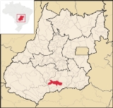
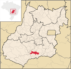
Goiatuba
Encyclopedia
| Goiatuba | |
|---|---|
| State | Goiás Goiás Goiás is a state of Brazil, located in the central part of the country. The name Goiás comes from the name of an indigenous community... |
| Coordinates: | 18°00′40"S 42°22′10"W |
| Area: | 2,475.10 km² |
| Population: | 31,225 (IBGE 2007) |
| Elevation: | 774 m above sea level |
| Postcode (CEP): | 75600-000 |
| Became a city: | 1938 |
| Mayor: | Marcelo Vercesi Coelho |
| Distance to Goiânia Goiânia -Climate:The city has a tropical wet and dry climate with an average temperature of . There's a wet season, from October to April, and a dry one, from May to September. Annual rainfall is around 1,520 mm.... : |
176 km. |
| IBGE statistical microregion: | Meia Ponte Microregion Meia Ponte Microregion The Meia Ponte Microregion is a statistical region of Goiás state, Brazil created by the IBGE . It is located south of the state capital, Goiânia, and includes 21 cities with a total population of 338,147 inhabitants . The total area is 21,229.00 km² and the population density is 14.39 inhab/km²... |
| Website: | Prefeitura Municipal de Goiatuba |
Municipality
A municipality is essentially an urban administrative division having corporate status and usually powers of self-government. It can also be used to mean the governing body of a municipality. A municipality is a general-purpose administrative subdivision, as opposed to a special-purpose district...
in south-central Goiás
Goiás
Goiás is a state of Brazil, located in the central part of the country. The name Goiás comes from the name of an indigenous community...
state, Brazil
Brazil
Brazil , officially the Federative Republic of Brazil , is the largest country in South America. It is the world's fifth largest country, both by geographical area and by population with over 192 million people...
. The population was 31,225 (2007 IBGE) in a total area of 2,475.10 km² (10/10/2002). Goiatuba is a large producer of grains, especially soybeans and corn.
Climate and Location
The average elevation is 775 meters, with an annual temperature average of 22 °C. The climate is typically tropical, moist and hot, with well-defined dry and rainy seasons. Average temperatures vary between 19 °C and 30 °C.Goiatuba is about 50 kilometers north of the Paranaíba River
Paranaíba River
The Paranaíba River is a Brazilian river whose source lies in the state of Minas Gerais in the Mata da Corda mountains, municipality of Rio Paranaíba, at an altitude of 1,148 meters; on the other face of this mountain chain are the sources of the Abaeté river, tributary of the São Francisco River...
, which forms the boundary with the state of Minas Gerais
Minas Gerais
Minas Gerais is one of the 26 states of Brazil, of which it is the second most populous, the third richest, and the fourth largest in area. Minas Gerais is the Brazilian state with the largest number of Presidents of Brazil, the current one, Dilma Rousseff, being one of them. The capital is the...
. It is 10 kilometers from the important interstate highway BR-153, which links Itumbiara
Itumbiara
Itumbiara is a small city and municipality in the extreme south of the state of Goiás, Brazil. The population was 100,000 in a total area of 2,461,3 km²...
with the state capital, Goiânia
Goiânia
-Climate:The city has a tropical wet and dry climate with an average temperature of . There's a wet season, from October to April, and a dry one, from May to September. Annual rainfall is around 1,520 mm....
. The distance to Goiânia is 176 kilometers.
Municipal boundaries are:
- North: AloândiaAloândiaAloândia is a small town and municipality in south Goiás state, Brazil. The population was 2,065 in 2007 and the municipal area was 102.1 km², one of the smallest in the state of Goiás.-Geographical Information:...
, VicentinópolisVicentinópolisVicentinópolis is a small town and municipality in south Goiás state, Brazil. The population was 5,919 inhabitants in 2005 in a total area of 737.2 km².-Location:...
and JoviâniaJoviâniaJoviânia is small town and municipality in south-central Goiás state, Brazil. The population was 6,731 in a total area of 454.9 km² .-Location:...
; - Northeast and East: MorrinhosMorrinhosMorrinhos may refer to one of the following cities in Brazil:* Morrinhos, Ceará, a city in the state of Ceará* Morrinhos, Goiás, a city in the state of Goiás* Morrinhos, Rio Grande do Sul, a city in the state of Rio Grande do Sul...
and Buriti AlegreBuriti AlegreBuriti Alegre is a small town and municipality in south Goiás state, Brazil. The population was 8,287 inhabitants in a total area of 897.4 km². Buriti Alegre is a large producer of poultry products.-Location and communications:...
; - South: ItumbiaraItumbiaraItumbiara is a small city and municipality in the extreme south of the state of Goiás, Brazil. The population was 100,000 in a total area of 2,461,3 km²...
and PanamáPanamá, GoiásPanamá is a small town and municipality in south Goiás state, Brazil.LocationPanamá is located in the Meia Ponte Microregion and is about 25 kilometers north of the border with the state of Minas Gerais. It is a short distance west of the important BR-153 highway which links São Paulo to Belém. ... - Southwest: CastelândiaCastelândiaright|250pxCastelândia is a small town and municipality in southwest Goiás state, Brazil. It is a large producer of sugar cane and soybeans.-Location:...
and Bom Jesus de GoiásBom Jesus de GoiásBom Jesus de Goiás is a town and municipality in south Goiás state, Brazil. It is a large producer of soybeans.-Geographical Information:The distance to the state capital, Goiânia, is 223 km and it is linked by highways BR-452 and GO-040...
; - West and Northwest: PorteirãoPorteirãoPorteirão is a small town and municipality in south Goiás state, Brazil.-Geographical Information:Porteirão is located in the Meia Ponte Microregion in the Rio dos Bois basin. It is connected by a state highway with the BR-452 highway, which connects Rio Verde with Itumbiara.The distance to the...
and EdéiaEdéiaEdéia is a small city and municipality in south-central Goiás state, Brazil.-Municipal Boundaries:Edéia is in the Vale do Rio dos Boisstatistical micro-region and has municipal boundaries with:*north: Indiara*west: Acreúna and Turvelândia...
- Districts: Marcianópolis.
- Hamlets: Rochelândia, Santo Antônio, Serrinha and Venda Seca.
Demographics
- Population density: 12.62 inhab/km² (2007)
- Population growth rate 1996/2007: 0.04.%
- Total population: 31,225
- Total population: 26,937
- Urban population in 2007: 28,548
- Rural population in 2007: 2,677
Economy
The economy is based on agriculture and cattle raising, but Goiatuba has several large enterprises. The areas are diverse: poultry processing, automobile sales, dairy products, and agricultural equipment. There is an alcohol distillery—Goiasa (Goiatuba Álcool ltda.), a seed producer—Sementes Selecta, a bed clothing factory—Bouquet, a dairy—Laticínio Polenghi (which produces most of the ice cream sold by McDonald's in Brazil), and two fertilizer plants—Adubos Sul Goiano, Adubos Terra Verde.Economic data
- Industrial units: 55 (06/2007)
- Retail units: 413 (08/2007)
- Banking institutions: Banco do Brasil S.A. - BRADESCO S.A. - Banco Itaú S.A. - CEF - Banco ABN AMRO Real S.A. - HSBC Bank Brasil S.A.-Banco Multiplo.. (01/06/2005)
- Dairies: Polenghi Indústrias Alimentícias Ltda.; - Coop. Mista dos Prod. de Soja de Goiatuba Ltda. (07/06/2005)
- Industrial Park: Distrito Agroindustrial - DIAGO
Main agricultural activities
- Cattle raising: 98,100 head (2006)
- Poultry: 301,000
- Agriculture: rice, sugarcane (13,000 hectares), sorghum, soybeans (62,000 hectares), and corn (10,750 hectares). There is modest production of citrus fruits, bananas, manioc, beans, and tomatoes. Statistics are from IBGE
- Number of farms: 745
- Total area: 152,077
- Area of permanent crops: 991
- Area of perennial crops: 71,500
- Area of natural pasture: 56,773
- Persons dependent on farming: 2,500 IBGE
Education and health
- Literacy rate: 88.8%
- Infant mortality rate: 13.30 in 1,000 live births
- Schools: 24 (2006)
- Students: 9,253
- Higher education: Faculdade de Filosofia e Ciências Humanas de Goiatuba- FAFICH - Pólo Universitário da UEG.
- Hospitals: 03 (2006)
- Hospital beds: 139
(Sepin/IBGE)
Prosperity
The municipality is one of the most prosperous in the state. Goiatuba got a score of 0.812 on the UN Human Development IndexHuman Development Index
The Human Development Index is a composite statistic used to rank countries by level of "human development" and separate "very high human development", "high human development", "medium human development", and "low human development" countries...
, putting it in 4th place out of 242 municipalities in the state. Nationally it was ranked 350 out of 5,507 municipalities. For the complete list see Frigoletto
Origin of the name
Goiatuba became a city in 1931, and the origen of the name is curious: "Goia" comes from the Goia Indians and "Tuba" is a Tupi-Guarani word meaning "big". So, Goiatuba is the same as "big Goiás".History
The settlement of the region took place in 1860 when ranchers from Minas GeraisMinas Gerais
Minas Gerais is one of the 26 states of Brazil, of which it is the second most populous, the third richest, and the fourth largest in area. Minas Gerais is the Brazilian state with the largest number of Presidents of Brazil, the current one, Dilma Rousseff, being one of them. The capital is the...
settled to raise cattle and grow crops. In 1892 land was donated to establish a town. The first name was "Bananeiras" because of the abundance of this fruit in the region. With the building of the first chapel the town was called São Sebastião das Bananeiras. In 1900 it was elevated to a district and became a municipality in 1931.