
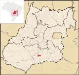
Joviânia
Encyclopedia
| Joviânia | |
|---|---|
| State | Goiás Goiás Goiás is a state of Brazil, located in the central part of the country. The name Goiás comes from the name of an indigenous community... |
| Coordinates: | 17°48′33"S 49°37′00"W |
| Area: | 454.9 km² |
| Population: | 6,731 (IBGE 2007) |
| Elevation: | 807 m above sea level |
| Postcode (CEP): | 75610-000 |
| Became a city: | 1958 |
| Mayor: | Romeu José Gonçalves |
| Distance to Goiânia Goiânia -Climate:The city has a tropical wet and dry climate with an average temperature of . There's a wet season, from October to April, and a dry one, from May to September. Annual rainfall is around 1,520 mm.... : |
162 km. |
| IBGE statistical microregion: | Meia Ponte Microregion Meia Ponte Microregion The Meia Ponte Microregion is a statistical region of Goiás state, Brazil created by the IBGE . It is located south of the state capital, Goiânia, and includes 21 cities with a total population of 338,147 inhabitants . The total area is 21,229.00 km² and the population density is 14.39 inhab/km²... |
| Website: | none |
Town
A town is a human settlement larger than a village but smaller than a city. The size a settlement must be in order to be called a "town" varies considerably in different parts of the world, so that, for example, many American "small towns" seem to British people to be no more than villages, while...
and municipality
Municipality
A municipality is essentially an urban administrative division having corporate status and usually powers of self-government. It can also be used to mean the governing body of a municipality. A municipality is a general-purpose administrative subdivision, as opposed to a special-purpose district...
in south-central Goiás
Goiás
Goiás is a state of Brazil, located in the central part of the country. The name Goiás comes from the name of an indigenous community...
state, Brazil
Brazil
Brazil , officially the Federative Republic of Brazil , is the largest country in South America. It is the world's fifth largest country, both by geographical area and by population with over 192 million people...
. The population was 6,731 (2007 IBGE) in a total area of 454.9 km² (10/10/2002).
Location
Joviânia is 177 kilometers from the state capital, GoiâniaGoiânia
-Climate:The city has a tropical wet and dry climate with an average temperature of . There's a wet season, from October to April, and a dry one, from May to September. Annual rainfall is around 1,520 mm....
. It is located approximately halfway between Rio Verde
Rio Verde
Rio Verde can mean the following:-Brazil:* Rio Verde, Goiás* Lucas do Rio Verde* Conceição do Rio Verde* Rio Verde de Mato Grosso-Brazil:29 rivers including:* Verde River...
and Morrinhos
Morrinhos
Morrinhos may refer to one of the following cities in Brazil:* Morrinhos, Ceará, a city in the state of Ceará* Morrinhos, Goiás, a city in the state of Goiás* Morrinhos, Rio Grande do Sul, a city in the state of Rio Grande do Sul...
. Highway connections with Goiânia
Goiânia
-Climate:The city has a tropical wet and dry climate with an average temperature of . There's a wet season, from October to April, and a dry one, from May to September. Annual rainfall is around 1,520 mm....
are made by GO-040 / Aragoiânia
Aragoiânia
Aragoiânia is a small town and municipality in central Goiás state, Brazil. The population was 7,243 in a total area of 219.5 km²....
/ Cromínia
Cromínia
Cromínia is a small town and municipality in south Goiás state, Brazil. It is famous for its chrome mines.-Geographical Information:Cromínia is located in the Meia Ponte Microregion, which includes the cities in the Meia Ponte River basin...
/ Pontalina
Pontalina
Pontalina is a small city and municipality in south-central Goiás state, Brazil.GeographyPontalina is 125 kilometers from the state capital, Goiânia. It is connected by highways BR-153 and GO-19...
/ Aloândia
Aloândia
Aloândia is a small town and municipality in south Goiás state, Brazil. The population was 2,065 in 2007 and the municipal area was 102.1 km², one of the smallest in the state of Goiás.-Geographical Information:...
/ GO-320. See Sepin for the list of distances in Goiás
Goiás
Goiás is a state of Brazil, located in the central part of the country. The name Goiás comes from the name of an indigenous community...
The vegetation is typical cerrado
Cerrado
The Cerrado, is a vast tropical savanna ecoregion of Brazil, particularly in the states of Gioas and Minas Gerais...
with trees with twisted branches and thick bark. The soil is rich in basalt and other unexplored minerals.
The climate is mild with average annual temperatures of around 23 °C.
Tourism
Most of the natural tourist spots are on private property. There are several waterfalls, rivers, and a vast flora and fauna.History
The origin of the town is related to the devotion that a rancher, Antônio Miguel da Costa, had for the Catholic representation of the Virgin, Nossa Senhora Abadia. The pioneer donated lands in the name of the "saint" with the intention of starting a town near GoiatubaGoiatuba
Goiatuba is a small city and municipality in south-central Goiás state, Brazil. The population was 31,225 in a total area of 2,475.10 km² . Goiatuba is a large producer of grains, especially soybeans and corn....
and about 170 kilometers from Goiânia
Goiânia
-Climate:The city has a tropical wet and dry climate with an average temperature of . There's a wet season, from October to April, and a dry one, from May to September. Annual rainfall is around 1,520 mm....
. In 1942 the town of Bela Vista was formed. Joviânia became a district of Goiatuba
Goiatuba
Goiatuba is a small city and municipality in south-central Goiás state, Brazil. The population was 31,225 in a total area of 2,475.10 km² . Goiatuba is a large producer of grains, especially soybeans and corn....
with the name "Joviânia" in 1953, the name being chosen in homage to Joviano Ferreira Barbosa, one of the first founders. In 1958 it became a municipality.
Political Data
- Mayor: Romeu José Gonçalves (January 2005)
- Vice-mayor: Juscelino Fernandes da Silva
- Number of council members: 9
- Number of eligible voters: 5,510 (2007)
Demographics
- Population density: 14.80 inhab./km² (2007)
- Urban and rural population in 2007: 6,086 and 645
- Urban and rural population in 1980: 4,110 and 2,210
- Population in 1980: 6,320
- Population growth rate 1996/2007: 0.13%
Economy
The economy is based on modest commerce, public employment, cattle raising, and agriculture. There was one dairy in 2005.Economic Data
(All economic data are from Sepin)
- Number of Industrial Establishments: 6 (June/2007)
- Dairies: Laticínios Terra Nova Ltda (07/06/2007)
- Banking Establishments: - Banco do Brasil S.A. - Banco Itaú S.A.
- Number of Retail Commercial Establishments: 107 (August/2007)
- Automobiles: 823
- Cattle (head) 38,285 (2006)
- Farms: 320 with 32,300 ha., of which 13,930 ha. were cultivated (2006)
- Pasture land: 12,291 ha.
- Woodland and forests: 5,939 ha.
- Workers in agriculture: 490
- Corn: 1,500 ha.
- Sorghum: 2,000 ha.
- Soybeans: 21,600 ha.
- Modest production of wheat and beans
Education (2006)
There were 1,324 students in primary schools and 246 students in middle and secondary schools.- Literacy Rate: 87.2%
Health (2007)
- Hospitals: 1
- Beds: 12
- Walk-in health clinics: 1
- Infant mortality rate: 19.67 (in 1,000 live births)
Municipal Human Development Index
Human Development Index
The Human Development Index is a composite statistic used to rank countries by level of "human development" and separate "very high human development", "high human development", "medium human development", and "low human development" countries...
- MHDI: 0.786
- State ranking: 19 (out of 242 municipalities in 2000)
- National ranking: 897 (out of 5,507 municipalities in 2000)
For the complete list see Frigoletto.com
Sources of Data
See also
- List of municipalities in Goiás
- Meia Ponte MicroregionMeia Ponte MicroregionThe Meia Ponte Microregion is a statistical region of Goiás state, Brazil created by the IBGE . It is located south of the state capital, Goiânia, and includes 21 cities with a total population of 338,147 inhabitants . The total area is 21,229.00 km² and the population density is 14.39 inhab/km²...