
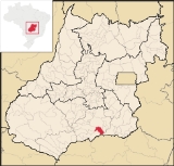
Buriti Alegre
Encyclopedia
| Buriti Alegre | |
|---|---|
| State | Goiás Goiás Goiás is a state of Brazil, located in the central part of the country. The name Goiás comes from the name of an indigenous community... |
| Coordinates: | 18°08′17"S 49°02′30"W |
| Area: | 897.4 km² |
| Population: | 8,287 (IBGE 2007) |
| Elevation: | 786 m above sea level |
| Postcode (CEP): | 75660-000 |
| Became a city: | 1920 |
| Mayor: | João Alfredo de Mello Neto |
| Distance to Goiânia Goiânia -Climate:The city has a tropical wet and dry climate with an average temperature of . There's a wet season, from October to April, and a dry one, from May to September. Annual rainfall is around 1,520 mm.... : |
210 km. |
| IBGE statistical microregion: | Meia Ponte Microregion Meia Ponte Microregion The Meia Ponte Microregion is a statistical region of Goiás state, Brazil created by the IBGE . It is located south of the state capital, Goiânia, and includes 21 cities with a total population of 338,147 inhabitants . The total area is 21,229.00 km² and the population density is 14.39 inhab/km²... |
| Website: | none |
Town
A town is a human settlement larger than a village but smaller than a city. The size a settlement must be in order to be called a "town" varies considerably in different parts of the world, so that, for example, many American "small towns" seem to British people to be no more than villages, while...
and municipality
Municipality
A municipality is essentially an urban administrative division having corporate status and usually powers of self-government. It can also be used to mean the governing body of a municipality. A municipality is a general-purpose administrative subdivision, as opposed to a special-purpose district...
in south Goiás
Goiás
Goiás is a state of Brazil, located in the central part of the country. The name Goiás comes from the name of an indigenous community...
state, Brazil
Brazil
Brazil , officially the Federative Republic of Brazil , is the largest country in South America. It is the world's fifth largest country, both by geographical area and by population with over 192 million people...
. The population was 8,287 inhabitants (2007) in a total area of 897.4 km². Buriti Alegre is a large producer of poultry products.
Location and communications
Buriti is located in the extreme south of the state between MorrinhosMorrinhos
Morrinhos may refer to one of the following cities in Brazil:* Morrinhos, Ceará, a city in the state of Ceará* Morrinhos, Goiás, a city in the state of Goiás* Morrinhos, Rio Grande do Sul, a city in the state of Rio Grande do Sul...
and Itumbiara
Itumbiara
Itumbiara is a small city and municipality in the extreme south of the state of Goiás, Brazil. The population was 100,000 in a total area of 2,461,3 km²...
. It is part of the Meia Ponte Microregion
Meia Ponte Microregion
The Meia Ponte Microregion is a statistical region of Goiás state, Brazil created by the IBGE . It is located south of the state capital, Goiânia, and includes 21 cities with a total population of 338,147 inhabitants . The total area is 21,229.00 km² and the population density is 14.39 inhab/km²...
. The distance to the state capital, Goiânia
Goiânia
-Climate:The city has a tropical wet and dry climate with an average temperature of . There's a wet season, from October to April, and a dry one, from May to September. Annual rainfall is around 1,520 mm....
, is 181 km. The distance to the important BR-153 highway is 26 km. The elevation is 620 meters above sea level.
Highway connections from Goiânia
Goiânia
-Climate:The city has a tropical wet and dry climate with an average temperature of . There's a wet season, from October to April, and a dry one, from May to September. Annual rainfall is around 1,520 mm....
are made by BR-153, passing through Aparecida de Goiânia
Aparecida de Goiânia
Aparecida de Goiânia is a city and municipality in central Goiás, Brazil. It is the second largest city in the state and a bustling industrial center.-Location:...
and Professor Jamil
Professor Jamil
Professor Jamil is a small town and municipality in south-central Goiás state, Brazil. The population was 3,298 in a total area of 347.4 km²...
and taking GO-419. Source: Sepin
Buriti has boundaries with the following municipalities: Morrinhos
Morrinhos
Morrinhos may refer to one of the following cities in Brazil:* Morrinhos, Ceará, a city in the state of Ceará* Morrinhos, Goiás, a city in the state of Goiás* Morrinhos, Rio Grande do Sul, a city in the state of Rio Grande do Sul...
(north); Itumbiara
Itumbiara
Itumbiara is a small city and municipality in the extreme south of the state of Goiás, Brazil. The population was 100,000 in a total area of 2,461,3 km²...
and Tupaciguara
Tupaciguara
Tupaciguara is a Brazilian municipality located in the west of the state of Minas Gerais. Its population as of 2007 was 23,076 living in a total area of 1,826 km². The city belongs to the statistical mesoregion of Triângulo Mineiro and Alto Paranaíba and to the statistical microregion of...
, (south); Água Limpa
Água Limpa
Água Limpa is a small town and municipality in south Goiás state, Brazil. The population was 2365 in 2005 and the municipal area was 454.3 km².Geographical Information...
(east); and Goiatuba
Goiatuba
Goiatuba is a small city and municipality in south-central Goiás state, Brazil. The population was 31,225 in a total area of 2,475.10 km² . Goiatuba is a large producer of grains, especially soybeans and corn....
(west).
The municipality is crossed by several rivers, the most important being the Paranaíba
Paranaíba River
The Paranaíba River is a Brazilian river whose source lies in the state of Minas Gerais in the Mata da Corda mountains, municipality of Rio Paranaíba, at an altitude of 1,148 meters; on the other face of this mountain chain are the sources of the Abaeté river, tributary of the São Francisco River...
and the Corumbá
Corumbá River
The Corumbá River is the most important river in the Central Plateau region of Brazil. Its source is in the Montes de Pireneus, near Pirenópolis, state of Goiás, near the boundary with the Federal District and its length ifs 567 km. It receives the waters of the Descoberto and São Bartolomeu,...
. There is also the Pirancanjuba, which flows into the Corumbá. The Lago das Brisas with an area of 778 km² is formed by the meeting of the waters of the Piracanjuba, Corumbá and Paranaíba.
History
Buriti Alegre began in 1910 with the construction of a chapel on the Buriti ranch. The chapel was dedicated to Our Lady of Aparecida and attracted pilgrims from around the region. In 1914 it became a district of CatalãoCatalão
Catalão is a small city and municipality located in the south of the state of Goiás, in Brazil. It is a large producer of grains, cattle, and phosphates and has a John Deere and Mitsubishi factory.-Demographics:*Population density: 17.85 inhab/km²...
. In 1927 it was dismembered to become a municipality.
Demographic and political data
- Population density in 2007: 9.23 inhab/km²
- Population growth rate 1996-2007: -0.79.%
- Total population in 2007: 8,287
- Total population in 1980: 8,803
- Urban population in 2007: 7,525
- Rural population in 2007: 762 (2,190 in 1980)
- City government in 2005: mayor (João Alfredo de Mello Neto), vice-mayor (José Martins Marques), and 09 councilpersons
(Seplan)
Economy
The economy is based on cattle raising and agriculture, which is diversified, producing corn, rice, soybeans, oranges, and bananas.In the 1950s Buriti had one of the largest herds of zebu cattle in the country, but today the number is around 80 thousand head. There are slaughterhouses for cattle and poultry in the town.
- Number of industrial establishments: 15
- Number of retail commercial establishments: 121
- Meat packing houses: Buriti American Beef Ltda.; - JMA Ind. de Alimentos Ltda. (22/05/2006)
- Financial institutions: Banco do Brasil S.A. (2007)
- Automobiles: 1,286
Agricultural Production
- Cattle raising: 79,000 head in 2006
- Poultry raising: 988,000 head in 2006
- Rice: 800 ha.
- Bananas: 440 ha.
- Oranges: 297 ha.
- Corn: 1,380 ha.
- Soybeans: 2,500 ha.
- Tomatoes: 46 ha.
(Seplan and IBGE)
Farm data 2006
- Farms: 366
- Total area: 130,347 ha.
- Area of permanent crops: 947 ha.
- Area of perennial crops: 13,545 ha.
- Area of natural pasture: 85,349 ha.
- Persons dependent on farming: 1,080
- Farms with tractors: 101
- Number of tractors: 198 IBGE
Health (2007)
- Health units: 03
- Hospitals: 01, with 34 beds in 2003
- Infant mortality rate in 2000: 21.47
- Infant mortality rate in 1990: 29.47
(Seplan and IBGE)
Education (2006)
- Schools: 09 with 2,487 students
- Higher education: none in 2005
- Literacy rate in 2000: 84.4
(Seplan and IBGE)
Ranking on the Municipal Human Development Index
Human Development Index
The Human Development Index is a composite statistic used to rank countries by level of "human development" and separate "very high human development", "high human development", "medium human development", and "low human development" countries...
- MHDI: 0.758
- State ranking: 62 (out of 242 municipalities)
- National ranking: 1,654 (out of 5,507 municipalities)
(*Frigoletto)