

Glaciers of Bhutan
Encyclopedia
The glaciers of Bhutan, which covered about 10 percent of the total surface area in the 1980s, are an important renewable source of water for Bhutan
's rivers. Fed by fresh snow each winter and slow melting in the summer, the glacier
s bring millions of litres of fresh water to Bhutan and downriver areas each year. Glacial melt also adds to monsoon-swollen rivers which may be a contributing factor to flooding. Where glacial movement temporary blocks riverflows, downstream areas may be threatened by glacial lake outburst flood
("GLOFs"). Although GLOFs are not a new phenomenon in Bhutan, their frequency has risen in the past three decades. Significant GLOFs occurred in 1957, 1960, 1968 and 1994, devastating lives and property downstream. According to the Bhutan Department of Energy however, the majority of rivers in Bhutan are more susceptible to fluctuation with changing rainfall patterns than to flooding directly attributable to glacier or snow melt.
s and subsidiary lakes, out of which 25 pose a risk of GLOFs
. The vast number of glaciers in Bhutan are classed as "valley" and "mountain glaciers," although significant numbers of "ice apron," and "niche glacier" types also exist. Some glacial lakes, such as Thorthormi Lake in Lunana Gewog
, are not a single bodies of water but collections supraglacial ponds. Most glacial lakes identified as potentially dangerous feed into the Manas River
and Puna Tsang (Sankosh) River water systems of north-central Bhutan. During a GLOF, residents of nearby downstream villages may have as little as twenty minutes to evacuate; floodwaters from one 1994 GLOF at Luggye lake took about seven hours to reach Punakha, some 90 kilometres (55.9 mi) downstream.
For public safety, these glaciers and glacial lakes are maintained by the Ministry of Economic Affairs' Department of Geology and Mines, an executive (cabinet) agency of the government of Bhutan. The Department, as part of its environmental "mitigation projects," aims to lower the levels of glacial lakes and thereby avert GLOF-related disaster. One such glacial lake mitigation project, for example, aimed to lower water levels by five meters over three years. The Department uses silent explosives and other means it considers environmentally friendly in order to minimize the ecological impact of its mitigation projects. These projects, however, remain difficult to conduct because of the weather, terrain, and relative lack of oxygen at the glacial lakes' altitudes. As of September 2010, GLOF early warning systems were slated for installation by mid-2011 in Punakha
and Wangdue Phodrang Districts at a cost of USD4.2 million.
, the topic is somewhat controversial. A 2008 United Nations
report suggested that due to rising temperatures, glaciers in Bhutan were retreating at a rate of 30–40 meters per year, poised to make many lakes burst their banks and send millions of gallons of floodwater downstream. This among many other climate-related issues
identified in the report prompted the regional association of government ministers to establish the Southeast Asia Regional Health Emergency Fund in Thimphu
in September 2007. Similarly, the member nations of South Asian Association for Regional Cooperation
(SAARC) adopted bilateral agreements including measures on climate change and glaciers at its summit in April 2010.
The 2008 UN report also indicated Himalayan glaciers would melt within 25 years, however Prime Minister Jigme Thinley expressed a more dim outlook in a press conference in late March 2010, stating, "Our glaciers are withdrawing very fast and we have reasons to worry that they may in fact disappear not in 2035, but even earlier." Further studies in 2009 indicated the rate of glacial melt in Bhutan was three times the world average, and that over the previous three decades regional temperatures had risen by 2.7 °C (36.9 °F). Satellite imaging also confirmed changes in glaciers and snow peaks, indicating increased runoff and decreased coverage. However, opinions varied on the effect of global warming in the Himalaya. According to US geological survey report, 66 glaciers in Bhutan have decreased by 8.1 percent in the last 30 years.
On the other hand, a study whose results were published in 2011 indicated glacial melt depended on several factors including debris cover, and that more than half of the glaciers in the Himalaya were stable or were in fact growing. Debris cover, such as rocks and mud, set apart the relatively stable glaciers of the Himalaya from the pristine glaciers of the Tibetan Plateau
, currently in fast retreat. The study, conducted by the Universities of California
and Potsdam
and published in the journal Nature Geoscience
, was based on 286 glaciers along the Himalaya and Hindu Kush from Bhutan to the Afghanistan-Pakistan border. Another preliminary survey conducted by a team of Japanese and Bhutanese scientists, including a glacio-microbiologist, glacio-ecologist and geologist, indicated that the presence of a peculiar microorganism on the surfaces of glaciers could accelerate glacial melting and eventually lead to a glacial outburst.
Bhutan
Bhutan , officially the Kingdom of Bhutan, is a landlocked state in South Asia, located at the eastern end of the Himalayas and bordered to the south, east and west by the Republic of India and to the north by the People's Republic of China...
's rivers. Fed by fresh snow each winter and slow melting in the summer, the glacier
Glacier
A glacier is a large persistent body of ice that forms where the accumulation of snow exceeds its ablation over many years, often centuries. At least 0.1 km² in area and 50 m thick, but often much larger, a glacier slowly deforms and flows due to stresses induced by its weight...
s bring millions of litres of fresh water to Bhutan and downriver areas each year. Glacial melt also adds to monsoon-swollen rivers which may be a contributing factor to flooding. Where glacial movement temporary blocks riverflows, downstream areas may be threatened by glacial lake outburst flood
Glacial lake outburst flood
A glacial lake outburst flood is a type of outburst flood that occurs when the dam containing a glacial lake fails. The dam can consist of glacier ice or a terminal moraine...
("GLOFs"). Although GLOFs are not a new phenomenon in Bhutan, their frequency has risen in the past three decades. Significant GLOFs occurred in 1957, 1960, 1968 and 1994, devastating lives and property downstream. According to the Bhutan Department of Energy however, the majority of rivers in Bhutan are more susceptible to fluctuation with changing rainfall patterns than to flooding directly attributable to glacier or snow melt.
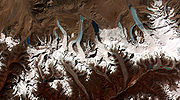
Glaciers and glacial lakes
Bhutanese territory contains some 677 glaciers and 2,674 glacial lakeGlacial lake
A glacial lake is a lake with origins in a melted glacier. Near the end of the last glacial period, roughly 10,000 years ago, glaciers began to retreat. A retreating glacier often left behind large deposits of ice in hollows between drumlins or hills. As the ice age ended, these melted to create...
s and subsidiary lakes, out of which 25 pose a risk of GLOFs
Glacial lake outburst flood
A glacial lake outburst flood is a type of outburst flood that occurs when the dam containing a glacial lake fails. The dam can consist of glacier ice or a terminal moraine...
. The vast number of glaciers in Bhutan are classed as "valley" and "mountain glaciers," although significant numbers of "ice apron," and "niche glacier" types also exist. Some glacial lakes, such as Thorthormi Lake in Lunana Gewog
Lunana Gewog
Lunana Gewog is a gewog of Gasa District, Bhutan. The village Lunana is the administrative center of Lunana Gewog....
, are not a single bodies of water but collections supraglacial ponds. Most glacial lakes identified as potentially dangerous feed into the Manas River
Manas River
The Manas River is a transboundary river in the Himalayan foothills between southern Bhutan and India.It is named after Manasa, the serpent god in Hindu mythology.It is the largest river system of Bhutan, among its four major river systems; the other three are Amo Chu or Torsa, Wong Chu or Raidak,...
and Puna Tsang (Sankosh) River water systems of north-central Bhutan. During a GLOF, residents of nearby downstream villages may have as little as twenty minutes to evacuate; floodwaters from one 1994 GLOF at Luggye lake took about seven hours to reach Punakha, some 90 kilometres (55.9 mi) downstream.
For public safety, these glaciers and glacial lakes are maintained by the Ministry of Economic Affairs' Department of Geology and Mines, an executive (cabinet) agency of the government of Bhutan. The Department, as part of its environmental "mitigation projects," aims to lower the levels of glacial lakes and thereby avert GLOF-related disaster. One such glacial lake mitigation project, for example, aimed to lower water levels by five meters over three years. The Department uses silent explosives and other means it considers environmentally friendly in order to minimize the ecological impact of its mitigation projects. These projects, however, remain difficult to conduct because of the weather, terrain, and relative lack of oxygen at the glacial lakes' altitudes. As of September 2010, GLOF early warning systems were slated for installation by mid-2011 in Punakha
Punakha District
Punakha District is one of the 20 dzongkhags comprising Bhutan. It is bordered by Thimphu, Gasa, and Wangdue Phodrang Districts...
and Wangdue Phodrang Districts at a cost of USD4.2 million.
Glacial retreat and controversy
Because the state of glaciers in Bhutan involves questions of climate changeClimate change
Climate change is a significant and lasting change in the statistical distribution of weather patterns over periods ranging from decades to millions of years. It may be a change in average weather conditions or the distribution of events around that average...
, the topic is somewhat controversial. A 2008 United Nations
United Nations
The United Nations is an international organization whose stated aims are facilitating cooperation in international law, international security, economic development, social progress, human rights, and achievement of world peace...
report suggested that due to rising temperatures, glaciers in Bhutan were retreating at a rate of 30–40 meters per year, poised to make many lakes burst their banks and send millions of gallons of floodwater downstream. This among many other climate-related issues
Environmental issues in Bhutan
There are a number of environmental issues in Bhutan. Among Bhutan's most pressing issues are traditional firewood collection, crop and flock protection, and waste disposal, as well as modern concerns such as industrial pollution, wildlife conservation, and climate change that threatens Bhutan's...
identified in the report prompted the regional association of government ministers to establish the Southeast Asia Regional Health Emergency Fund in Thimphu
Thimphu
Thimphu also spelt Thimpu, is the capital and largest city of Bhutan. It is situated in the western central part of Bhutan and the surrounding valley is one of Bhutan's dzongkhags, the Thimphu District. The city became the capital of Bhutan in 1961...
in September 2007. Similarly, the member nations of South Asian Association for Regional Cooperation
South Asian Association for Regional Cooperation
The South Asian Association for Regional Cooperation is an organisation of South Asian nations, founded in December 1985 by Ziaur Rahman and dedicated to economic, technological, social, and cultural development emphasising collective self-reliance. Its seven founding members are Bangladesh,...
(SAARC) adopted bilateral agreements including measures on climate change and glaciers at its summit in April 2010.
The 2008 UN report also indicated Himalayan glaciers would melt within 25 years, however Prime Minister Jigme Thinley expressed a more dim outlook in a press conference in late March 2010, stating, "Our glaciers are withdrawing very fast and we have reasons to worry that they may in fact disappear not in 2035, but even earlier." Further studies in 2009 indicated the rate of glacial melt in Bhutan was three times the world average, and that over the previous three decades regional temperatures had risen by 2.7 °C (36.9 °F). Satellite imaging also confirmed changes in glaciers and snow peaks, indicating increased runoff and decreased coverage. However, opinions varied on the effect of global warming in the Himalaya. According to US geological survey report, 66 glaciers in Bhutan have decreased by 8.1 percent in the last 30 years.
On the other hand, a study whose results were published in 2011 indicated glacial melt depended on several factors including debris cover, and that more than half of the glaciers in the Himalaya were stable or were in fact growing. Debris cover, such as rocks and mud, set apart the relatively stable glaciers of the Himalaya from the pristine glaciers of the Tibetan Plateau
Tibetan Plateau
The Tibetan Plateau , also known as the Qinghai–Tibetan Plateau is a vast, elevated plateau in Central Asia covering most of the Tibet Autonomous Region and Qinghai, in addition to smaller portions of western Sichuan, southwestern Gansu, and northern Yunnan in Western China and Ladakh in...
, currently in fast retreat. The study, conducted by the Universities of California
University of California
The University of California is a public university system in the U.S. state of California. Under the California Master Plan for Higher Education, the University of California is a part of the state's three-tier public higher education system, which also includes the California State University...
and Potsdam
University of Potsdam
The University of Potsdam is a German university, situated across four campuses in Potsdam, Brandenburg, including the New Palace of Sanssouci and the Park Babelsberg.- Profile :...
and published in the journal Nature Geoscience
Nature Geoscience
Nature Geoscience is a monthly, peer reviewed, scientific journal published by Nature Publishing Group. The Chief Editor is Heike Langenberg. The first issue was published in January 2008.-Scope:...
, was based on 286 glaciers along the Himalaya and Hindu Kush from Bhutan to the Afghanistan-Pakistan border. Another preliminary survey conducted by a team of Japanese and Bhutanese scientists, including a glacio-microbiologist, glacio-ecologist and geologist, indicated that the presence of a peculiar microorganism on the surfaces of glaciers could accelerate glacial melting and eventually lead to a glacial outburst.
List of glaciers and glacier lakes in Bhutan
- Lunana glacier group, Lunana GewogLunana GewogLunana Gewog is a gewog of Gasa District, Bhutan. The village Lunana is the administrative center of Lunana Gewog....
(Jigme Dorji National ParkJigme Dorji National ParkThe Jigme Dorji National Park, named after the late Jigme Dorji Wangchuk, is the second-largest National Park of Bhutan. It occupies almost the entire Gasa District, as well as the northern areas of Thimphu District, Paro District, Punakha, and Wangdue Phodrang Districts...
)- Thorthormi Glacier and Lake. Thorthormi Lake, which appeared sometime after 1967, is the largest lake in Lunana, with a width of 30 metres (98.4 ft).
- Raphstreng (Rapstreng) Glacier and Lake. Raphstreng Lake appeared in 1958. It is just over 2 square kilometre (0.77220431718507 sq mi) and 107 metres (351 ft) deep.
- Luggye (Lugge) Glaciers 1, 2, and Lake. Luggye Lake first appeared in 1967, has a depth of 142 metres (465.9 ft), and a width of 30 metres (98.4 ft). It produced a significant GLOF in 1994.
- Bechung Glacier and Lake.
- Roduphu Glacial Lake, Laya GewogLaya GewogLaya Gewog is a gewog of Gasa District, Bhutan. The capital of gewog is the town Laya....
(Mo Chhu (River) basinMo ChhuMo Chhu is a major river in Bhutan. The word "Chhu" means "river" or "water" in Dzongkha, the official national language in Bhutan. The river rises in Gasa Dzongkhag near the border between Bhutan and Tibet. From there, the Mo Chhu flows generally southward to Punakha in central Bhutan, where it...
). - Sinchhe Glacial Lake, Laya GewogLaya GewogLaya Gewog is a gewog of Gasa District, Bhutan. The capital of gewog is the town Laya....
(Mo Chhu (River) basinMo ChhuMo Chhu is a major river in Bhutan. The word "Chhu" means "river" or "water" in Dzongkha, the official national language in Bhutan. The river rises in Gasa Dzongkhag near the border between Bhutan and Tibet. From there, the Mo Chhu flows generally southward to Punakha in central Bhutan, where it...
). - Gangchentag Lake at the base of Gangchentag Mountain, Laya GewogLaya GewogLaya Gewog is a gewog of Gasa District, Bhutan. The capital of gewog is the town Laya....
, Gasa DistrictGasa DistrictGasa District or Gasa Dzongkhag is one of the 20 dzongkhags comprising Bhutan. Its capital is Gasa Dzong near Gasa. It is located in the far north of the county and spans the Middle and High Himalayas. The dominant language of the district is Dzongkha, the national language...
. - Wochey (Wachey) Glacier and Lake (Pho Chhu (River) basin). It is the single longest glacier in Bhutan at 20.1 kilometres (12.5 mi).
- Northern Basin glacier group, disputed area along the Gasa DistrictGasa DistrictGasa District or Gasa Dzongkhag is one of the 20 dzongkhags comprising Bhutan. Its capital is Gasa Dzong near Gasa. It is located in the far north of the county and spans the Middle and High Himalayas. The dominant language of the district is Dzongkha, the national language...
-ChinaChinaChinese civilization may refer to:* China for more general discussion of the country.* Chinese culture* Greater China, the transnational community of ethnic Chinese.* History of China* Sinosphere, the area historically affected by Chinese culture...
border (northeast of Jigme Dorji National ParkJigme Dorji National ParkThe Jigme Dorji National Park, named after the late Jigme Dorji Wangchuk, is the second-largest National Park of Bhutan. It occupies almost the entire Gasa District, as well as the northern areas of Thimphu District, Paro District, Punakha, and Wangdue Phodrang Districts...
). Runoff from these glaciers flows north into Tibet. - Kuri Chhu (River)Kuri ChhuThe Kuri Chhu, also known as the Lhobrak, is a major river of eastern Bhutan, that has formed a scenic valley with high peaks and steep hills...
basin glacier group, Lhuntse and Trashiyangtse Districts in eastern Bhutan. These small glaciers have very low maximum and minimum elevations, between 5000 metres (16,404.2 ft) and 4000 metres (13,123.4 ft). - Teri Kang Glacier and Lake, Laya GewogLaya GewogLaya Gewog is a gewog of Gasa District, Bhutan. The capital of gewog is the town Laya....
(Jigme Dorji National ParkJigme Dorji National ParkThe Jigme Dorji National Park, named after the late Jigme Dorji Wangchuk, is the second-largest National Park of Bhutan. It occupies almost the entire Gasa District, as well as the northern areas of Thimphu District, Paro District, Punakha, and Wangdue Phodrang Districts...
). This dam-reinforced lake produced a devastating GLOF in the 1960s, partially destroying Punakha DzongPunakha DzongThe Punakha Dzong, also known as Pungtang Dechen Photrang Dzong is the administrative centre of Punakha dzongkhag in Punakha, Bhutan. Constructed by Zhabdrung Ngawang Namgyal in 1637–38, it is the second oldest and second largest dzong in Bhutan and one of its most majestic structures...
. - Gankerphuensum Glacier, near Gankerphuensum (Mangde River basin). At an elevation of approximately 7500 metres (24,606.3 ft), it is the highest glacier in Bhutan.
- Jomolhari Glacier, Jomolhari (Chomo Lhāri), Paro DistrictParo DistrictParo District is the name of a district , valley, river and town in Bhutan. It is one of the most historic valleys in Bhutan. Both trade goods and invading Tibetans came over the pass at the head of the valley, giving Paro the closest cultural connection with Tibet of any Bhutanese district...
(Pa River basin). At an elevation of 7300 metres (23,950.1 ft), it is the second-highest glacier in Bhutan. - Chubda Glacier and Lake, Bumthang DistrictBumthang DistrictBumthang District is one of the 20 dzongkhag comprising Bhutan. It is the most historic dzongkhag if the number of ancient temples and sacred sites is counted...
in north-central Bhutan (upper Chamkhar Chhu basin). Its large supraglacial lake was identified as a potential danger in 2001. - Tsokar Glacier and Lake, Bumthang DistrictBumthang DistrictBumthang District is one of the 20 dzongkhag comprising Bhutan. It is the most historic dzongkhag if the number of ancient temples and sacred sites is counted...
(Chamkhar Chu basin).
See also
- Retreat of glaciers since 1850Retreat of glaciers since 1850The retreat of glaciers since 1850 affects the availability of fresh water for irrigation and domestic use, mountain recreation, animals and plants that depend on glacier-melt, and in the longer term, the level of the oceans...
- Climate changeClimate changeClimate change is a significant and lasting change in the statistical distribution of weather patterns over periods ranging from decades to millions of years. It may be a change in average weather conditions or the distribution of events around that average...
- Geography of BhutanGeography of BhutanThe Kingdom of Bhutan is a sovereign nation, located towards the eastern extreme of the Himalayas mountain range. It is fairly evenly sandwiched between the sovereign territory of two nations: first, the People's Republic of China on the north and northwest. There are approximately 470 kilometres...
- List of rivers of Bhutan