

Gildersleeve Mountain
Encyclopedia
Gildersleeve Mountain is a summit located in Kirtland
, Ohio
, United States
.
Gildersleeve Mountain is interesting and important because it is within one of the largest and most densely populated metropolitan areas in the United States
(regional population 2.9 million). It is a relatively unspoiled and unique area just 18 miles (29 km) from downtown Cleveland
. While this is not unique in a region where urban and suburban forest preserves abound, it is one of only two natural areas with higher elevations and unique rock outcroppings. Little Mountain
, which is near the Holden Arboretum
, is similar to Gildersleeve Mountain but is accessible on guided walks only.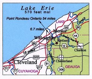
. The shoreline of Lake Erie is approximately 6.7 miles (10.8 km) north west of the summit.
Gildersleeve Mountain marks the beginning of the Allegheny Plateau
in the area. Its northern slopes transition down the Portage escarpment to lake plain. The southern side of the feature has a much less dramatic transition, falling only 150 feet (45.7 m) to the surrounding highlands.
Gildersleeve Mountain is one of the more obvious geographic features of the Cleveland region
. It is visible when the view is unobstructed by buildings or trees from downtown Cleveland, Mayfield Heights, and from the shore and waters of Lake Erie. It is obvious when looking to the south from the lake or northeast from any tall building near the lake shore in Cuyahoga County.
Gildersleeve Mountain also offers spectacular views of Lake Erie from locations near the summit. From one location the view to the west and southwest affords a view of the downtown Cleveland skyline, 18 miles (29 km) away.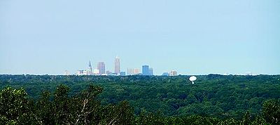 On clear days the stacks in Lorain or Avon Lake may be visible, and on exceptional days the plume from cooling towers at the Davis-Besse
, or Permian, nuclear power stations may be visible far to the west.
Point Rondeau, Ontario
, 54 miles (86.9 km) away, is the closest point on the Canadian shore of Lake Erie. However, the distance to the horizon at the lookout is only 28.7 miles (46.2 km), so while the Canadian waters of Lake Erie are visible from Gildersleeve Mountain, the Canadian shore is not. On clear nights, lights are visible on the horizon to the northwest but it is uncertain if these are on the Canadian shore.
The views to the north and east were once very good with most of the landscape of Kirtland and the lakeshore of Lake County visible. Features from Perry to Willoughby were visible, but the view has not been maintained as trees that were once managed have been allowed to obstruct the view.
About 60% of Gildersleeve Mountain is within the 370 acres (1.5 km²) Chapin Forest Reservation, which was acquired by the state of Ohio in 1949 and has been managed by the Lake County Metropolitan Park District since 1966, located along State Route 306/Chillicothe Road. It is managed as a recreational facility for the public and features picnic areas, sports facilities, and playgrounds, although none of these are located on the higher elevations. Trails that may be used for hiking, bicycling, horseback riding, and cross country skiing in winter cross the public lands and circle the summit.
Over 50 private residences are on the slopes of Gildersleeve Mountain. An active natural gas
well was drilled in 2006, and the forested areas are logged for hardwood maple and oak. Commercial maple syrup
production was once done using the native Sugar Maple stands for sap, but this activity is no longer viable. Gildersleeve Mountain was once an important source of sandstone for building and for sand and gravel. Commercial exploitation of these resources ceased in 1968.
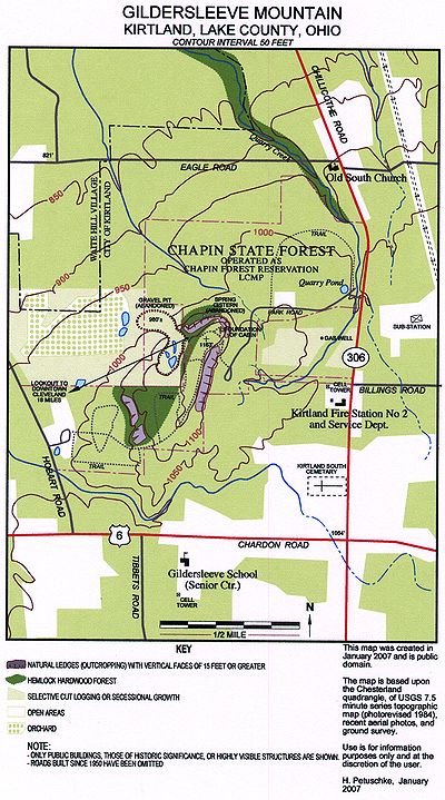 As the map to the right shows, the topography of Gildersleeve Mountain had been changed significantly by human activity. The sand and gravel quarry on the west side was active for more than 100 years before shutting down in 1968 and being acquired by the state of Ohio. The road and some trails have been used for the same period of time, but others were put in by the state of Ohio after it acquired the property in 1949, and still others have been added or re-routed by Lake Metroparks.
Clearcut and selective logging has also changed the land features. The most recent logging was a selective cut of about 40 acres (161,874.4 m²) on the east side in the spring of 2006.
Development, although not shown on the map, also changed the topography. Some of the cleared areas and some of the forested areas are subdivided and have light duty roads with private homes. This is mostly on the southeast side of Gildersleeve Mountain. In 2007 the former quarry access area and orchard on the west side will be developed into home sites.
Another feature of interest is a cabin foundation on the northern end of the summit. There was a chimney associated with this foundation until it was blown down during the Ohio Fireworks Derecho
that struck the Cleveland region on July 4, 1969. This storm also toppled several hundred trees on Gildersleeve Mountain. The foundation is now in an overgrown area of what used to be the Panorama Point picnic area. Although signage still calls out this area, the panoramic view from this location is no longer viable because trees have been allowed to grow and obscure the view.
Also of interest are the remnants of a cistern at the base of an outcropping to the west of the cabin foundation. These may be found by following the base of the rock outcroppings to the west of the Panorama Point area. The water caught by this cistern is filtered though the Sharon conglomerate and seeps out of the base of the outcropping.
There are numerous seeps all around Gildersleeve Mountain, and they are the source of the creeks that run off into the Chagrin River
watershed. These creeks are augmented by rain and snow melt. They create ravine systems that cut though layers of rock and provide interesting places to study local geology. The Quarry Creek ravine accessible from the Old South Church property cuts down to the Cleveland shale layer before crossing Eagle road.
Around 380 to 300 million years ago the area was on the Earth’s equator as a part of the Pangaea
super continent. With the uplifting of the continental plate, the area went from continental shelf to shallow sea. The geology of the area reflects this transition.
The lowest visible bedrock is Chagrin shale. Named for the Chagrin River
and easily found in the river valley, Chagrin shale is blue gray in color, an offshore alluvial, silt shale of the Devonian
period. This layer is found below about 800 feet (243.8 m) msl and is found when drilling wells on the slopes of Gildersleeve Mountain.
The next layer is Cleveland shale. This is a black shale that is an important source of local fossils. Again Cleveland shale is not visible on Gildersleeve Mountain but can easily be found in the nearby Chagrin River valley between 800 and 900 feet (274.3 m) msl.
Bedford shale is found above the Cleveland Shale layer. This material marks the uncertain transition between the Devonian and Pennsylvanian
periods in the region. This layer is found in the ravines that run off the slopes of Gildersleeve Mountain. Bedford shale is a sand shale and is characterized by its roughly 90° cleavage
pattern. Pieces of Bedford shale can look as if they were cut by human hands and are found up to about 950 feet (289.6 m) msl.
A thin strata of Sunbury shale is often found above the Bedford Shale. This is a thin layered, black shale, of more silty origins, possibly from a period when the waters running into the ocean basin were running slower, creating finer particles.
Berea sandstone
is found from around 950 feet (289.6 m) msl to roughly 1070 feet (326.1 m) msl. However, at this point it should be mentioned that the rock structure around Gildersleeve Mountain is by no means uniform. Millions of years of glaciation and resulting erosion and fill have resulted in many ravines that have been subsequently filled with glacial till and alluvial clays. Still, Berea sandstone is found in outcroppings and in other areas on Gildersleeve Mountain. In the nineteenth century it was quarried from the Stannard Quarry, what is now Quarry Pond, near Chillicothe Road. This material was used to build Kirtland Temple
and other local structures. Berea sandstone is still used as a local building material.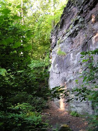 Sharon conglomerate is found beginning around 1070 feet (326.1 m) msl. It is the predominant outcropping on Gildersleeve Mountain. Sharon Conglomerate is a sandstone imbedded with white quartz
pebbles. It is hypothesized this rock was created by fast-running streams, running down ancient mountains. Faster-running water carried larger pebbles along with the sand, and this was deposited very near shore, or in river or stream deltas and estuaries. It is Sharon conglomerate outcroppings that up make most of the spectacular ledges that are found on the southeast, north, and western sides of Gildersleeve Mountain. The ledges have been split and eroded to create up to three distinct sets of formations separated by deeper crevasses. In some areas there are vertical faces of over 30 feet (9.1 m) with very steep slopes at the base. In these areas the elevation change is dramatic, going from 1060 feet (323.1 m) to 1130 feet (344.4 m) in under 150 feet (45.7 m) of horizontal distance.
As mentioned earlier, glaciation has played an important part in the geology of Gildersleeve Mountain. During the Wisconsin glaciation
, ice sheets more than a mile thick covered the region. Glaciers are the major erosive force in the region and ground down the higher elevations while scooping out the [Great Lakes]. The hard Sharon conglomerate is more resistant to this grinding action.
Glacial ice is not the only erosive force to act upon Gildersleeve Mountain. Glacial melt released huge amounts of water that flooded the landscape. This water cut ravines and filled others with clay and rocky debris.
The Gildersleeve Mountain we see today is the result of hundreds of millions of years of erosion. The sedimentary rocks were created by ancient erosion of the land, and the worn-down relic of a higher peak is also the result of erosion.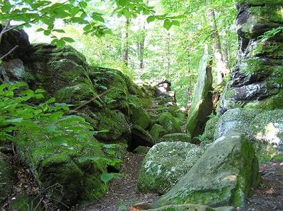 Flora:
Prior to European settlement the area was a vast northern hardwood forest. On Gildersleeve mountain this probably consisted of 3 types of forest. Beech Maple forest, Hemlock hardwood forest, and Oak Hickory forest. as remnant stands of all three types remain. Old growth Oak and Maple can be found in a few locations where they were not claimed by 19th century logging. In second growth areas mixed mesophytic forest is predominant and generally these trees are about 100 to 150 years old.
The Hemlock hardwood forest is one of the most unusual and interesting, but not uncommon on the Allegheny Plateau in the region. The Chestnut Oak is an interesting species found on the summit.
Herbacious species are numerous. The most interesting are found in the crevasses and cooler areas in the ledge system. Wild flower species are typical of the area. the brilliant red, Cardinal flower, is found near creeks. Red and white trilium are found where deer have not browsed. Cress, foam flowers, blue cohosh, and occasionally orchids are found. A wide variety of ferns can be found. A rare species of grass may be found in the ledges. Unfortunately deer browse has seriously reduced the abundance of herbacious species. The outcroppings have additional interest because club mosses and lichens can be found on their surfaces.
Interesting fungi are present, but these disappear quicky given the fact that Gildersleeve mountain is within a major American metropolitan area.
Fauna:
The seeps and creeks running along the slopes povide a unique habitat. Dragonflies and damselflies (odonata) are of special interest to naturalists of the region and Gildersleeve mountain has been a site of recent discoveries. The first Tiger Spiketail, documented in Ohio, was discovered on Gildersleeve Mountain, in 2004. Other rare dragonflies documented on Gildersleeve Mountain include Gray Petaltail, Comet Darner, Occelated Darner, and Twin Spotted Spiketail.
Crayfish are found in the creeks. Fish species are not found in the shallow fast running creeks at these elevations but blue gills and largemouth bass can be found in the ponds.
Reptiles and amphibians are found here as well. Vernal pools hold salamanders and the Red Eft phase of the Eastern Newt. is found on the forest floor of the steeper slopes. Black rat snakes, and Garter snakes are common. One of Kirtland’s first settlers, Christopher Crary, recalled rattlesnakes in the 1820s or 30s in his memoir: "On Gildersleeve mountain twenty three were killed in one day, and they soon became extinct.". These were probably Eastern timber rattlesnake. American Toads are found along with, Spring peepers and Gray tree frogs. Pickerel frogs are found in the creeks. Green frogs are found in the vernal pools and other water. Bullfrogs are found in the ponds on the northwestern slope
Many species of birds can be found on Gildersleeve mountain. Barred Owl
s are common year round residents and can be found by listening and watching carefully. They will often sit close to the trials in clear view but hidden in the shadows of the branches. Most visitors are oblivious to their presence. Cooper’s Hawks, Red-shouldered Hawks, Broad-winged Hawks and Red-tailed Hawks also nest on the slopes. Wild Turkey nests here. The spectacular, Pileated Woodpecker
, as well as Hairy, Downey, and Red-bellied woodpeckers are common year round. Great Creasted Flycatcher, Eastern Phoebe, Eastern Wood Pewee and Acadian Flycatcher are common nesters. Eastern Bluebird
is common in the more open areas, Wood Thrush is found nesting wherever trees create a canopy overhead. Black-capped Chickadees, Tufted Titmice, White-breasted Nuthatch are common residents and Red -breasted nuthatch is sometimes found. Red-eyed Vireos are common tree top nesters. Hooded Warbler and American Redstart are common nesters in the forest under story. Ovenbird, nests on the forest floor and Louisiana Waterthrush
nest is the ravines and creek beds. Eastern Towhee is found in the underbrush. Scarlet Tanager
, Rose-breasted Grosbeak, American Goldfinch, House Finch, and Song Sparrow are also common nesters
Rarer nesting species are found here as well. Sharp-shinned hawk
s will sometimes nest in the deeper parts of the woods. Winter Wren
, was found nesting in 2009. Blue-headed Vireo
, is found in the ledges and Hemlocks. Hermit Thrush
is a probable nesting species. Black-throated Green Warbler
nests in the ledges and Hemlock hardwood forest. Purple finch
is an occasional nester. Dark-eyed Junco
, is a prolific nester and abundant year round on Gildersleeve mountain, not just in the winter, as in most of the Cleveland region. Pine Siskin
is another very rare nesting species first verified in 2009.
Interesting and very rare migrant species have been found on or seen from Gildersleeve mountain. Tundra Swans are expected in fall as they fly over on their way south. Northern Harrier, has been seen in the spring. Most Spectacular have been Western Kingbird
(fall 2005) and Kirtland’s Warbler (fall 2004). Uncommon winter visitors have included Pine Siskins, Common Redpoll, and Evening Grosbeak.
Mammals found on Gildersleeve mountain include the usual and the unexpected. Opossum, various shrews, moles, and several species of bats. Mice and voles are common with White footed deer mouse being the most abundant. Red, Gray (both gray and black morphs) and Eastern Fox Squirrel are common and southern Flying Squirrel is occasionally found. Eastern Chipmunks are abundant. Raccoons are common. Three weasels, least, short tailed and long tailed have all been found. Striped skunk is less common than in more sub urban residential areas. White tailed deer are common. Red fox have declined as Coyote have increased in numbers. Evidence of Bobcat has been found but confirmation of this species will require a specimen. In June 2004, a black bear made yet another contemporary appearance on Gildersleeve mountain. This time leaving tracks, tearing up a trash receptacles.
Kirtland, Ohio
Kirtland is a city in Lake County, Ohio, USA. The population was 6,670 at the 2000 census. Kirtland is famous for being the early headquarters of the Latter Day Saint movement.-Origins of Kirtland:...
, Ohio
Ohio
Ohio is a Midwestern state in the United States. The 34th largest state by area in the U.S.,it is the 7th‑most populous with over 11.5 million residents, containing several major American cities and seven metropolitan areas with populations of 500,000 or more.The state's capital is Columbus...
, United States
United States
The United States of America is a federal constitutional republic comprising fifty states and a federal district...
.
Gildersleeve Mountain is interesting and important because it is within one of the largest and most densely populated metropolitan areas in the United States
Greater Cleveland
Greater Cleveland is a nickname for the metropolitan area surrounding Cleveland, Ohio and is part of what used to be the Connecticut Western Reserve.Northeast Ohio refers to a similar but substantially larger area as described below...
(regional population 2.9 million). It is a relatively unspoiled and unique area just 18 miles (29 km) from downtown Cleveland
Cleveland, Ohio
Cleveland is a city in the U.S. state of Ohio and is the county seat of Cuyahoga County, the most populous county in the state. The city is located in northeastern Ohio on the southern shore of Lake Erie, approximately west of the Pennsylvania border...
. While this is not unique in a region where urban and suburban forest preserves abound, it is one of only two natural areas with higher elevations and unique rock outcroppings. Little Mountain
Little Mountain (Ohio)
Little Mountain is a hill on the border of Lake and Geauga Counties in Ohio, with an elevation of . It sits along the border of Concord Township, Lake County, Ohio and Chardon Township, Geauga County, Ohio...
, which is near the Holden Arboretum
Holden Arboretum
The Holden Arboretum, in Kirtland, Ohio, USA, is one of the largest arboretums and botanical gardens in the United States, with over 3,500 acres , 600 acres of which are devoted to collections and gardens. Diverse natural areas and ecologically sensitive habitats make up the rest of the holdings...
, is similar to Gildersleeve Mountain but is accessible on guided walks only.
Geography
The summit of Gildersleeve Mountain is 1163 feet (354.5 m) above sea level. 593 feet (180.7 m) above Lake ErieLake Erie
Lake Erie is the fourth largest lake of the five Great Lakes in North America, and the tenth largest globally. It is the southernmost, shallowest, and smallest by volume of the Great Lakes and therefore also has the shortest average water residence time. It is bounded on the north by the...
. The shoreline of Lake Erie is approximately 6.7 miles (10.8 km) north west of the summit.
Gildersleeve Mountain marks the beginning of the Allegheny Plateau
Allegheny Plateau
The Allegheny Plateau is a large dissected plateau area in western and central New York, northern and western Pennsylvania, northern and western West Virginia, and eastern Ohio...
in the area. Its northern slopes transition down the Portage escarpment to lake plain. The southern side of the feature has a much less dramatic transition, falling only 150 feet (45.7 m) to the surrounding highlands.
Gildersleeve Mountain is one of the more obvious geographic features of the Cleveland region
Greater Cleveland
Greater Cleveland is a nickname for the metropolitan area surrounding Cleveland, Ohio and is part of what used to be the Connecticut Western Reserve.Northeast Ohio refers to a similar but substantially larger area as described below...
. It is visible when the view is unobstructed by buildings or trees from downtown Cleveland, Mayfield Heights, and from the shore and waters of Lake Erie. It is obvious when looking to the south from the lake or northeast from any tall building near the lake shore in Cuyahoga County.
Gildersleeve Mountain also offers spectacular views of Lake Erie from locations near the summit. From one location the view to the west and southwest affords a view of the downtown Cleveland skyline, 18 miles (29 km) away.
Davis-Besse
Davis-Besse Nuclear Power Station is a nuclear power plant with a single pressurized water reactor, also referred to as a light water reactor. As of 2011, it is operated by the FirstEnergy Nuclear Operating Company subsidiary of FirstEnergy Corp...
, or Permian, nuclear power stations may be visible far to the west.
Point Rondeau, Ontario
Ontario
Ontario is a province of Canada, located in east-central Canada. It is Canada's most populous province and second largest in total area. It is home to the nation's most populous city, Toronto, and the nation's capital, Ottawa....
, 54 miles (86.9 km) away, is the closest point on the Canadian shore of Lake Erie. However, the distance to the horizon at the lookout is only 28.7 miles (46.2 km), so while the Canadian waters of Lake Erie are visible from Gildersleeve Mountain, the Canadian shore is not. On clear nights, lights are visible on the horizon to the northwest but it is uncertain if these are on the Canadian shore.
The views to the north and east were once very good with most of the landscape of Kirtland and the lakeshore of Lake County visible. Features from Perry to Willoughby were visible, but the view has not been maintained as trees that were once managed have been allowed to obstruct the view.
About 60% of Gildersleeve Mountain is within the 370 acres (1.5 km²) Chapin Forest Reservation, which was acquired by the state of Ohio in 1949 and has been managed by the Lake County Metropolitan Park District since 1966, located along State Route 306/Chillicothe Road. It is managed as a recreational facility for the public and features picnic areas, sports facilities, and playgrounds, although none of these are located on the higher elevations. Trails that may be used for hiking, bicycling, horseback riding, and cross country skiing in winter cross the public lands and circle the summit.
Over 50 private residences are on the slopes of Gildersleeve Mountain. An active natural gas
Natural gas
Natural gas is a naturally occurring gas mixture consisting primarily of methane, typically with 0–20% higher hydrocarbons . It is found associated with other hydrocarbon fuel, in coal beds, as methane clathrates, and is an important fuel source and a major feedstock for fertilizers.Most natural...
well was drilled in 2006, and the forested areas are logged for hardwood maple and oak. Commercial maple syrup
Maple syrup
Maple syrup is a syrup usually made from the xylem sap of sugar maple, red maple, or black maple trees, although it can also be made from other maple species such as the bigleaf maple. In cold climates, these trees store starch in their trunks and roots before the winter; the starch is then...
production was once done using the native Sugar Maple stands for sap, but this activity is no longer viable. Gildersleeve Mountain was once an important source of sandstone for building and for sand and gravel. Commercial exploitation of these resources ceased in 1968.
Topology
Clearcut and selective logging has also changed the land features. The most recent logging was a selective cut of about 40 acres (161,874.4 m²) on the east side in the spring of 2006.
Development, although not shown on the map, also changed the topography. Some of the cleared areas and some of the forested areas are subdivided and have light duty roads with private homes. This is mostly on the southeast side of Gildersleeve Mountain. In 2007 the former quarry access area and orchard on the west side will be developed into home sites.
Another feature of interest is a cabin foundation on the northern end of the summit. There was a chimney associated with this foundation until it was blown down during the Ohio Fireworks Derecho
Ohio Fireworks Derecho
The Ohio Fireworks Derecho , was a severe wind event that took place during the evening hours of July 4, 1969. It affected the northern half of the state of Ohio as well as portions of Pennsylvania, southern Michigan and extreme southwestern New York...
that struck the Cleveland region on July 4, 1969. This storm also toppled several hundred trees on Gildersleeve Mountain. The foundation is now in an overgrown area of what used to be the Panorama Point picnic area. Although signage still calls out this area, the panoramic view from this location is no longer viable because trees have been allowed to grow and obscure the view.
Also of interest are the remnants of a cistern at the base of an outcropping to the west of the cabin foundation. These may be found by following the base of the rock outcroppings to the west of the Panorama Point area. The water caught by this cistern is filtered though the Sharon conglomerate and seeps out of the base of the outcropping.
There are numerous seeps all around Gildersleeve Mountain, and they are the source of the creeks that run off into the Chagrin River
Chagrin River
The Chagrin River is located in Northeast Ohio. The river has two branches, the Aurora Branch and East Branch. Its name is believed to stem from what the local Erie Indians used to call it, the "Sha-ga-rin", or "Clear Water". Given the clear flowing nature of especially the East Branch of the...
watershed. These creeks are augmented by rain and snow melt. They create ravine systems that cut though layers of rock and provide interesting places to study local geology. The Quarry Creek ravine accessible from the Old South Church property cuts down to the Cleveland shale layer before crossing Eagle road.
Natural history
Geology:Around 380 to 300 million years ago the area was on the Earth’s equator as a part of the Pangaea
Pangaea
Pangaea, Pangæa, or Pangea is hypothesized as a supercontinent that existed during the Paleozoic and Mesozoic eras about 250 million years ago, before the component continents were separated into their current configuration....
super continent. With the uplifting of the continental plate, the area went from continental shelf to shallow sea. The geology of the area reflects this transition.
The lowest visible bedrock is Chagrin shale. Named for the Chagrin River
Chagrin River
The Chagrin River is located in Northeast Ohio. The river has two branches, the Aurora Branch and East Branch. Its name is believed to stem from what the local Erie Indians used to call it, the "Sha-ga-rin", or "Clear Water". Given the clear flowing nature of especially the East Branch of the...
and easily found in the river valley, Chagrin shale is blue gray in color, an offshore alluvial, silt shale of the Devonian
Devonian
The Devonian is a geologic period and system of the Paleozoic Era spanning from the end of the Silurian Period, about 416.0 ± 2.8 Mya , to the beginning of the Carboniferous Period, about 359.2 ± 2.5 Mya...
period. This layer is found below about 800 feet (243.8 m) msl and is found when drilling wells on the slopes of Gildersleeve Mountain.
The next layer is Cleveland shale. This is a black shale that is an important source of local fossils. Again Cleveland shale is not visible on Gildersleeve Mountain but can easily be found in the nearby Chagrin River valley between 800 and 900 feet (274.3 m) msl.
Bedford shale is found above the Cleveland Shale layer. This material marks the uncertain transition between the Devonian and Pennsylvanian
Pennsylvanian
The Pennsylvanian is, in the ICS geologic timescale, the younger of two subperiods of the Carboniferous Period. It lasted from roughly . As with most other geochronologic units, the rock beds that define the Pennsylvanian are well identified, but the exact date of the start and end are uncertain...
periods in the region. This layer is found in the ravines that run off the slopes of Gildersleeve Mountain. Bedford shale is a sand shale and is characterized by its roughly 90° cleavage
Cleavage (geology)
This article is about rock cleavage, for cleavage in minerals see Cleavage Cleavage, in structural geology and petrology, describes a type of planar rock feature that develops as a result of deformation and metamorphism. The degree of deformation and metamorphism along with rock type determines the...
pattern. Pieces of Bedford shale can look as if they were cut by human hands and are found up to about 950 feet (289.6 m) msl.
A thin strata of Sunbury shale is often found above the Bedford Shale. This is a thin layered, black shale, of more silty origins, possibly from a period when the waters running into the ocean basin were running slower, creating finer particles.
Berea sandstone
Sandstone
Sandstone is a sedimentary rock composed mainly of sand-sized minerals or rock grains.Most sandstone is composed of quartz and/or feldspar because these are the most common minerals in the Earth's crust. Like sand, sandstone may be any colour, but the most common colours are tan, brown, yellow,...
is found from around 950 feet (289.6 m) msl to roughly 1070 feet (326.1 m) msl. However, at this point it should be mentioned that the rock structure around Gildersleeve Mountain is by no means uniform. Millions of years of glaciation and resulting erosion and fill have resulted in many ravines that have been subsequently filled with glacial till and alluvial clays. Still, Berea sandstone is found in outcroppings and in other areas on Gildersleeve Mountain. In the nineteenth century it was quarried from the Stannard Quarry, what is now Quarry Pond, near Chillicothe Road. This material was used to build Kirtland Temple
Kirtland Temple
The Kirtland Temple is a National Historic Landmark in Kirtland, Ohio, USA, on the eastern edge of the Cleveland metropolitan area. Owned and operated by the Community of Christ, formerly the Reorganized Church of Jesus Christ of Latter Day Saints , the house of worship was the first temple to be...
and other local structures. Berea sandstone is still used as a local building material.
Quartz
Quartz is the second-most-abundant mineral in the Earth's continental crust, after feldspar. It is made up of a continuous framework of SiO4 silicon–oxygen tetrahedra, with each oxygen being shared between two tetrahedra, giving an overall formula SiO2. There are many different varieties of quartz,...
pebbles. It is hypothesized this rock was created by fast-running streams, running down ancient mountains. Faster-running water carried larger pebbles along with the sand, and this was deposited very near shore, or in river or stream deltas and estuaries. It is Sharon conglomerate outcroppings that up make most of the spectacular ledges that are found on the southeast, north, and western sides of Gildersleeve Mountain. The ledges have been split and eroded to create up to three distinct sets of formations separated by deeper crevasses. In some areas there are vertical faces of over 30 feet (9.1 m) with very steep slopes at the base. In these areas the elevation change is dramatic, going from 1060 feet (323.1 m) to 1130 feet (344.4 m) in under 150 feet (45.7 m) of horizontal distance.
As mentioned earlier, glaciation has played an important part in the geology of Gildersleeve Mountain. During the Wisconsin glaciation
Wisconsin glaciation
The last glacial period was the most recent glacial period within the current ice age occurring during the last years of the Pleistocene, from approximately 110,000 to 10,000 years ago....
, ice sheets more than a mile thick covered the region. Glaciers are the major erosive force in the region and ground down the higher elevations while scooping out the [Great Lakes]. The hard Sharon conglomerate is more resistant to this grinding action.
Glacial ice is not the only erosive force to act upon Gildersleeve Mountain. Glacial melt released huge amounts of water that flooded the landscape. This water cut ravines and filled others with clay and rocky debris.
The Gildersleeve Mountain we see today is the result of hundreds of millions of years of erosion. The sedimentary rocks were created by ancient erosion of the land, and the worn-down relic of a higher peak is also the result of erosion.
Prior to European settlement the area was a vast northern hardwood forest. On Gildersleeve mountain this probably consisted of 3 types of forest. Beech Maple forest, Hemlock hardwood forest, and Oak Hickory forest. as remnant stands of all three types remain. Old growth Oak and Maple can be found in a few locations where they were not claimed by 19th century logging. In second growth areas mixed mesophytic forest is predominant and generally these trees are about 100 to 150 years old.
The Hemlock hardwood forest is one of the most unusual and interesting, but not uncommon on the Allegheny Plateau in the region. The Chestnut Oak is an interesting species found on the summit.
Herbacious species are numerous. The most interesting are found in the crevasses and cooler areas in the ledge system. Wild flower species are typical of the area. the brilliant red, Cardinal flower, is found near creeks. Red and white trilium are found where deer have not browsed. Cress, foam flowers, blue cohosh, and occasionally orchids are found. A wide variety of ferns can be found. A rare species of grass may be found in the ledges. Unfortunately deer browse has seriously reduced the abundance of herbacious species. The outcroppings have additional interest because club mosses and lichens can be found on their surfaces.
Interesting fungi are present, but these disappear quicky given the fact that Gildersleeve mountain is within a major American metropolitan area.
Fauna:
The seeps and creeks running along the slopes povide a unique habitat. Dragonflies and damselflies (odonata) are of special interest to naturalists of the region and Gildersleeve mountain has been a site of recent discoveries. The first Tiger Spiketail, documented in Ohio, was discovered on Gildersleeve Mountain, in 2004. Other rare dragonflies documented on Gildersleeve Mountain include Gray Petaltail, Comet Darner, Occelated Darner, and Twin Spotted Spiketail.
Crayfish are found in the creeks. Fish species are not found in the shallow fast running creeks at these elevations but blue gills and largemouth bass can be found in the ponds.
Reptiles and amphibians are found here as well. Vernal pools hold salamanders and the Red Eft phase of the Eastern Newt. is found on the forest floor of the steeper slopes. Black rat snakes, and Garter snakes are common. One of Kirtland’s first settlers, Christopher Crary, recalled rattlesnakes in the 1820s or 30s in his memoir: "On Gildersleeve mountain twenty three were killed in one day, and they soon became extinct.". These were probably Eastern timber rattlesnake. American Toads are found along with, Spring peepers and Gray tree frogs. Pickerel frogs are found in the creeks. Green frogs are found in the vernal pools and other water. Bullfrogs are found in the ponds on the northwestern slope
Many species of birds can be found on Gildersleeve mountain. Barred Owl
Barred Owl
The Barred Owl is a large typical owl. It goes by many other names, including eight hooter, rain owl, wood owl, and striped owl, but is probably best known as the hoot owl.-Description:...
s are common year round residents and can be found by listening and watching carefully. They will often sit close to the trials in clear view but hidden in the shadows of the branches. Most visitors are oblivious to their presence. Cooper’s Hawks, Red-shouldered Hawks, Broad-winged Hawks and Red-tailed Hawks also nest on the slopes. Wild Turkey nests here. The spectacular, Pileated Woodpecker
Pileated Woodpecker
The Pileated Woodpecker is a very large North American woodpecker, almost crow-sized, inhabiting deciduous forests in eastern North America, the Great Lakes, the boreal forests of Canada, and parts of the Pacific coast. It is also the largest woodpecker in America.Adults are long, and weigh...
, as well as Hairy, Downey, and Red-bellied woodpeckers are common year round. Great Creasted Flycatcher, Eastern Phoebe, Eastern Wood Pewee and Acadian Flycatcher are common nesters. Eastern Bluebird
Eastern Bluebird
The Eastern Bluebird, Sialia sialis, is a small thrush found in open woodlands, farmlands and orchards, and most recently can be spotted in suburban areas. It is the state bird of Missouri and New York....
is common in the more open areas, Wood Thrush is found nesting wherever trees create a canopy overhead. Black-capped Chickadees, Tufted Titmice, White-breasted Nuthatch are common residents and Red -breasted nuthatch is sometimes found. Red-eyed Vireos are common tree top nesters. Hooded Warbler and American Redstart are common nesters in the forest under story. Ovenbird, nests on the forest floor and Louisiana Waterthrush
Louisiana Waterthrush
The Louisiana Waterthrush is a New World warbler. It breeds in eastern North America from southernmost Canada and south through the eastern USA, excluding Florida and the coast....
nest is the ravines and creek beds. Eastern Towhee is found in the underbrush. Scarlet Tanager
Scarlet Tanager
The Scarlet Tanager is a medium-sized American songbird. Formerly placed in the tanager family , it and other members of its genus are now classified in the cardinal family . The species's plumage and vocalizations are similar to other members of the cardinal family.-Description:Adults have pale...
, Rose-breasted Grosbeak, American Goldfinch, House Finch, and Song Sparrow are also common nesters
Rarer nesting species are found here as well. Sharp-shinned hawk
Sharp-shinned Hawk
The Sharp-shinned Hawk is a small hawk. In fact, "sharp-shins" or "sharpies" are the smallest to reside in USA and Canada, though some Neotropical species are smaller...
s will sometimes nest in the deeper parts of the woods. Winter Wren
Winter Wren
The Winter Wren is a very small North American bird and a member of the mainly New World wren family Troglodytidae. It was once lumped with Troglodytes pacificus of western North America and Troglodytes troglodytes of Eurasia under the name Winter Wren.It breeds in coniferous forests from British...
, was found nesting in 2009. Blue-headed Vireo
Blue-headed Vireo
The Blue-headed Vireo is a Neotropical migrating song bird found in North and Central America. There are currently two recognized sub-species that belong to the Blue-headed Vireo. It has a range that extends across Canada and the eastern coast of the United-States, Mexico and some of Central America...
, is found in the ledges and Hemlocks. Hermit Thrush
Hermit Thrush
The Hermit Thrush is a medium-sized North American thrush. It is not very closely related to the other North American migrant species of Catharus, but rather to the Mexican Russet Nightingale-thrush.-Description:...
is a probable nesting species. Black-throated Green Warbler
Black-throated Green Warbler
The Black-throated Green Warbler, Setophaga virens, is a small songbird of the New World warbler family.It is 12 cm long and weighs 9 g, and has an olive-green crown, a yellow face with olive markings, a thin pointed bill, white wing bars, an olive-green back and pale underparts with...
nests in the ledges and Hemlock hardwood forest. Purple finch
Purple Finch
The Purple Finch, Carpodacus purpureus, is a bird in the finch family Fringillidae.-Taxonomy:The Purple Finch is one of 24 birds in the genus Carpodacus and is included in the finch...
is an occasional nester. Dark-eyed Junco
Dark-eyed Junco
The Dark-eyed Junco is the best-known species of the juncos, a genus of small grayish American sparrows. This bird is common across much of temperate North America and in summer ranges far into the Arctic...
, is a prolific nester and abundant year round on Gildersleeve mountain, not just in the winter, as in most of the Cleveland region. Pine Siskin
Pine Siskin
The Pine Siskin is a North American bird in the finch family. It is a migratory bird with an extremely sporadic winter range.-Description:...
is another very rare nesting species first verified in 2009.
Interesting and very rare migrant species have been found on or seen from Gildersleeve mountain. Tundra Swans are expected in fall as they fly over on their way south. Northern Harrier, has been seen in the spring. Most Spectacular have been Western Kingbird
Western Kingbird
The Western Kingbird is a large tyrant flycatcher.Adults are grey-olive on the upperparts with a grey head and a dark line through the eyes; the underparts are light becoming light orange-yellow on the lower breast and belly. They have a long black tail with white outer feathers...
(fall 2005) and Kirtland’s Warbler (fall 2004). Uncommon winter visitors have included Pine Siskins, Common Redpoll, and Evening Grosbeak.
Mammals found on Gildersleeve mountain include the usual and the unexpected. Opossum, various shrews, moles, and several species of bats. Mice and voles are common with White footed deer mouse being the most abundant. Red, Gray (both gray and black morphs) and Eastern Fox Squirrel are common and southern Flying Squirrel is occasionally found. Eastern Chipmunks are abundant. Raccoons are common. Three weasels, least, short tailed and long tailed have all been found. Striped skunk is less common than in more sub urban residential areas. White tailed deer are common. Red fox have declined as Coyote have increased in numbers. Evidence of Bobcat has been found but confirmation of this species will require a specimen. In June 2004, a black bear made yet another contemporary appearance on Gildersleeve mountain. This time leaving tracks, tearing up a trash receptacles.