

Geography of the Bahamas
Encyclopedia
The Bahamas
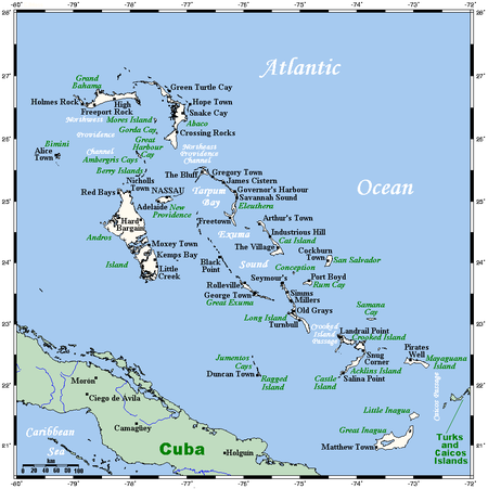
The Bahamas , officially the Commonwealth of the Bahamas, is a nation consisting of 29 islands, 661 cays, and 2,387 islets . It is located in the Atlantic Ocean north of Cuba and Hispaniola , northwest of the Turks and Caicos Islands, and southeast of the United States...
is a group of about 700 atoll
Atoll
An atoll is a coral island that encircles a lagoon partially or completely.- Usage :The word atoll comes from the Dhivehi word atholhu OED...
s and cay
Cay
A cay , also spelled caye or key, is a small, low-elevation, sandy island formed on the surface of coral reefs. Cays occur in tropical environments throughout the Pacific, Atlantic and Indian Oceans , where they provide habitable and agricultural land for hundreds of thousands of people...
s in the western Atlantic Ocean
Atlantic Ocean
The Atlantic Ocean is the second-largest of the world's oceanic divisions. With a total area of about , it covers approximately 20% of the Earth's surface and about 26% of its water surface area...
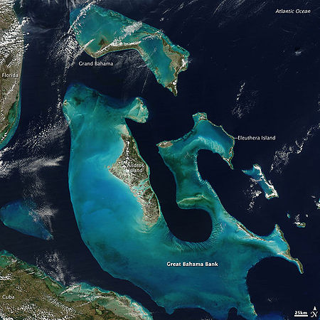
, of which only between 30 and 40 are inhabited. The largest of the islands is Andros Island, located 120 miles (193.1 km) southeast of Florida
Florida
Florida is a state in the southeastern United States, located on the nation's Atlantic and Gulf coasts. It is bordered to the west by the Gulf of Mexico, to the north by Alabama and Georgia and to the east by the Atlantic Ocean. With a population of 18,801,310 as measured by the 2010 census, it...
. The Bimini
Bimini
Bimini is the westernmost district of the Bahamas composed of a chain of islands located about 53 miles due east of Miami, Florida. Bimini is the closest point in the Bahamas to the mainland United States and approximately 137 miles west-northwest of Nassau...
islands are to its northwest. To the North is the island of Grand Bahama
Grand Bahama
Grand Bahama is one of the northernmost of the islands of the Bahamas, and the closest major island to the United States, lying off the state of Florida. Grand Bahama is the fifth largest island in the Bahamas island chain of approximately 700 islands and 2,400 cays...
, home to the second largest city in the country, Freeport
Freeport, Bahamas
Freeport is a city, district and free trade zone located on the island of Grand Bahama of the North-west Bahamas. In 1955, Wallace Groves, a Virginian financier with lumber interests in Grand Bahama, was granted 50,000 acres Freeport is a city, district and free trade zone located on the island of...
. The island of Great Abaco is to its east. In the far south is the island of Great Inagua, the second largest island in the country. Other notable islands include Eleuthera
Eleuthera
Eleuthera is an island in The Bahamas, lying 50 miles east of Nassau. It is very long and thin—110 miles long and in places little more than a mile wide. According to the 2000 Census, the population of Eleuthera is approximately 8,000...
, Cat Island
Cat Island (Bahamas)
Cat Island is in the central Bahamas, and one of its districts, and has the nation's highest point. Its Mount Alvernia rises to 206 ft and is topped by a monastery called The Hermitage. This assembly of buildings was erected by the Franciscan "Brother Jerome" .The first European settlers were...
, San Salvador Island
San Salvador Island
San Salvador Island, also known as Watlings Island, is an island and district of the Bahamas. Until 1986, when the National Geographic Society suggested Samana Cay, it was widely believed that during his first expedition to the New World, San Salvador Island was the first land sighted and visited...
, Acklins
Acklins
Acklins is an island and district of the Bahamas.It is one of a group of islands arranged along a large, shallow lagoon called the Bight of Acklins, of which the largest are Crooked Island in the north and Acklins in the southeast, and the smaller are Long Cay [ 8sq mi] in the northwest, and...
, Crooked Island
Crooked Island (Bahamas)
Crooked Island is an island and district, part of a group of Bahamian islands defining a large, shallow lagoon called the Bight of Acklins, of which the largest are Crooked Island in the north and Acklins in the south-east, and the smaller are Long Cay in the north-west, and Castle Island in the...
, and Mayaguana
Mayaguana
Mayaguana is the most easterly island and district of the Bahamas. It is one of only a few Bahamian islands which retain their Lucayan names. The population of Mayaguana in the 2000 census was 259, amounting to an estimate 312 in 2010...
. Nassau
Nassau, Bahamas
Nassau is the capital, largest city, and commercial centre of the Commonwealth of the Bahamas. The city has a population of 248,948 , 70 percent of the entire population of The Bahamas...
is the capital and largest city, located on New Providence
New Providence
New Providence is the most populous island in the Bahamas, containing more than 70% of the total population. It also houses the national capital city, Nassau.The island was originally under Spanish control following Christopher Columbus' discovery of the New World, but the Spanish government showed...
. The islands have a subtropical climate, moderated by the Gulf Stream
Gulf Stream
The Gulf Stream, together with its northern extension towards Europe, the North Atlantic Drift, is a powerful, warm, and swift Atlantic ocean current that originates at the tip of Florida, and follows the eastern coastlines of the United States and Newfoundland before crossing the Atlantic Ocean...
.
The islands are surface projections of the three oceanic Bahama Banks
Bahama Banks
The Bahama Banks are the submerged carbonate platforms that make up much of the Bahama Archipelago. The term is usually applied in referring to either the Great Bahama Bank around Andros Island, or the Little Bahama Bank of Grand Bahama Island and Great Abaco, which are the largest of the...
- the Little Bahama Bank, the Great Bahama Bank, and the westernmost Cay Sal Bank
Cay Sal Bank
Cay Sal Bank is the third largest and the westernmost of the Bahama Banks. It is located between 23º27'N - 24º10'N and 079º25'W – 080º35'W...
. The highest point is only 63 meters above sea level on Cat Island; the island of New Providence, where the capital city of Nassau is located, reaches a maximum elevation of only thirty-seven meters. The land on the Bahamas has a foundation of fossil coral
Coral
Corals are marine animals in class Anthozoa of phylum Cnidaria typically living in compact colonies of many identical individual "polyps". The group includes the important reef builders that inhabit tropical oceans and secrete calcium carbonate to form a hard skeleton.A coral "head" is a colony of...
, but much of the rock is oolitic
Oolite
Oolite is a sedimentary rock formed from ooids, spherical grains composed of concentric layers. The name derives from the Hellenic word òoion for egg. Strictly, oolites consist of ooids of diameter 0.25–2 mm; rocks composed of ooids larger than 2 mm are called pisolites...
limestone
Limestone
Limestone is a sedimentary rock composed largely of the minerals calcite and aragonite, which are different crystal forms of calcium carbonate . Many limestones are composed from skeletal fragments of marine organisms such as coral or foraminifera....
; the stone is derived from the disintegration of coral reef
Coral reef
Coral reefs are underwater structures made from calcium carbonate secreted by corals. Coral reefs are colonies of tiny living animals found in marine waters that contain few nutrients. Most coral reefs are built from stony corals, which in turn consist of polyps that cluster in groups. The polyps...
s and seashells. The land is primarily either rocky or mangrove
Mangrove
Mangroves are various kinds of trees up to medium height and shrubs that grow in saline coastal sediment habitats in the tropics and subtropics – mainly between latitudes N and S...
swamp
Swamp
A swamp is a wetland with some flooding of large areas of land by shallow bodies of water. A swamp generally has a large number of hammocks, or dry-land protrusions, covered by aquatic vegetation, or vegetation that tolerates periodical inundation. The two main types of swamp are "true" or swamp...
. Low scrub covers much of the surface area. Pineyards are found on four of the northern islands: Grand Bahama, Great Abaco, New Providence, and Andros. On some of the southern islands, low-growing tropical hardwood flourishes. Although some soil is very fertile, it is also very thin. Only a few freshwater lakes and just one river, located on Andros Island, are found in the Bahamas.
Climate
The climate of the archipelago is semitropical and has two seasons, summer and winter. During the summer, which extends from May through November, the climate is dominated by warm, moist tropical air masses moving north through the Caribbean. Midsummer temperatures range from 74 to 89 °F (23.3 to 31.7 °C) with a relative humidity of 60 to 100%. In winter months, extending from December through April, the climate is affected by the movement of cold polar masses from North America. Temperatures during the winter months range from 62 to 77 °F (16.7 to 25 °C).While there has never been a freeze reported in the Bahamas, the temperature can fall to 37 °F (2.8 °C) during Arctic outbreaks that affect nearby Florida
Florida
Florida is a state in the southeastern United States, located on the nation's Atlantic and Gulf coasts. It is bordered to the west by the Gulf of Mexico, to the north by Alabama and Georgia and to the east by the Atlantic Ocean. With a population of 18,801,310 as measured by the 2010 census, it...
. Snow has been reported to have mixed with rain in Freeport in January 1977, the same time that it snowed in the Miami area. The temperature was about 41 °F (5 °C) at the time.
Yearly rainfall averages 55.7 inches (1,414.8 mm) and is usually concentrated in the May–June and August–October periods. Rainfall often occurs in short-lived, fairly intense showers accompanied by strong gusty winds, which are then followed by clear skies.
Winds are predominantly easterly throughout the year but tend to become northeasterly from October to April and southeasterly from May to September. These winds seldom exceed twenty-four kilometers per hour except during hurricane season. Although the hurricane season officially lasts from June to November, most hurricanes in the Bahamas occur between July and October. Before a long lull in activity which ended in the 1990s, the last one to strike was Hurricane David
Hurricane David
Hurricane David was the fourth named tropical cyclone, second hurricane, and first major hurricane of the 1979 Atlantic hurricane season. A Category 5 hurricane on the Saffir-Simpson Hurricane Scale, David was among the deadliest hurricanes in the latter half of the 20th century, killing...
in September 1979. Damage was estimated at US$1.8 million and mainly affected agricultural products. The most intense twentieth-century hurricane to strike the Bahamas was the 1929 Florida hurricane
1929 Florida Hurricane
The 1929 Bahamas Hurricane was the second hurricane and the only major hurricane during the very inactive 1929 Atlantic hurricane season. The hurricane was the only hurricane to cause any significant damage, resulting in $676,000 in damage...
; winds of up to 140 miles per hour (225.3 km/h) were recorded. Many lives were lost, and there was extensive damage to buildings, homes, and boats.
Location
Atlantic Ocean
The Atlantic Ocean is the second-largest of the world's oceanic divisions. With a total area of about , it covers approximately 20% of the Earth's surface and about 26% of its water surface area...
, chain islands in the North Atlantic Ocean
Atlantic Ocean
The Atlantic Ocean is the second-largest of the world's oceanic divisions. With a total area of about , it covers approximately 20% of the Earth's surface and about 26% of its water surface area...
, southeast of Florida
Florida
Florida is a state in the southeastern United States, located on the nation's Atlantic and Gulf coasts. It is bordered to the west by the Gulf of Mexico, to the north by Alabama and Georgia and to the east by the Atlantic Ocean. With a population of 18,801,310 as measured by the 2010 census, it...
, northeast of Cuba
Cuba
The Republic of Cuba is an island nation in the Caribbean. The nation of Cuba consists of the main island of Cuba, the Isla de la Juventud, and several archipelagos. Havana is the largest city in Cuba and the country's capital. Santiago de Cuba is the second largest city...
and northwest of the Turks and Caicos Islands
Turks and Caicos Islands
The Turks and Caicos Islands are a British Overseas Territory and overseas territory of the European Union consisting of two groups of tropical islands in the Caribbean, the larger Caicos Islands and the smaller Turks Islands, known for tourism and as an offshore financial centre.The Turks and...
.
Area
- total: 13,940 km²
- county comparison to the world: 168
- land: 10 070 km²
- water: 3 870 km²
Area comparative
- AustraliaAustraliaAustralia , officially the Commonwealth of Australia, is a country in the Southern Hemisphere comprising the mainland of the Australian continent, the island of Tasmania, and numerous smaller islands in the Indian and Pacific Oceans. It is the world's sixth-largest country by total area...
comparative: 6 times larger than the Australian Capital TerritoryAustralian Capital TerritoryThe Australian Capital Territory, often abbreviated ACT, is the capital territory of the Commonwealth of Australia and is the smallest self-governing internal territory... - CanadaCanadaCanada is a North American country consisting of ten provinces and three territories. Located in the northern part of the continent, it extends from the Atlantic Ocean in the east to the Pacific Ocean in the west, and northward into the Arctic Ocean...
comparative: a little over twice the size of Prince Edward IslandPrince Edward IslandPrince Edward Island is a Canadian province consisting of an island of the same name, as well as other islands. The maritime province is the smallest in the nation in both land area and population... - PolandPolandPoland , officially the Republic of Poland , is a country in Central Europe bordered by Germany to the west; the Czech Republic and Slovakia to the south; Ukraine, Belarus and Lithuania to the east; and the Baltic Sea and Kaliningrad Oblast, a Russian exclave, to the north...
comparative: slightly smaller than Świętokrzyskie VoivodeshipSwietokrzyskie VoivodeshipŚwiętokrzyskie Voivodeship, or Świętokrzyskie Province , is one of the 16 voivodeships into which Poland is presently divided. It is situated in central Poland, in the historical province of Lesser Poland, and takes its name from the Świętokrzyskie mountain range... - United KingdomUnited KingdomThe United Kingdom of Great Britain and Northern IrelandIn the United Kingdom and Dependencies, other languages have been officially recognised as legitimate autochthonous languages under the European Charter for Regional or Minority Languages...
comparative: slightly smaller than Northern IrelandNorthern IrelandNorthern Ireland is one of the four countries of the United Kingdom. Situated in the north-east of the island of Ireland, it shares a border with the Republic of Ireland to the south and west... - United StatesUnited StatesThe United States of America is a federal constitutional republic comprising fifty states and a federal district...
comparative: slightly smaller than ConnecticutConnecticutConnecticut is a state in the New England region of the northeastern United States. It is bordered by Rhode Island to the east, Massachusetts to the north, and the state of New York to the west and the south .Connecticut is named for the Connecticut River, the major U.S. river that approximately...
Elevation extremes
- lowest point: Atlantic Ocean 0 m
- highest point: Mount AlverniaMount AlverniaMount Alvernia is located on Cat Island in the Bahamas and is the highest point in the country at above sea level. The Mountain shares its name with a school in Montego Bay, Jamaica....
on Cat IslandCat Island-North America:* Cat Island , Bahamas* Cat Island , United States* Cat Island , United States* Cat Island , United States* Cat Island , United States...
63 meters (206.7 feet)
Natural hazards
- Hurricanes and other tropical storms that cause extensive flood and wind damage.
Environment - International agreements
Party to these agreements:- Biodiversity, Climate Change, Climate Change-Kyoto Protocol, Desertification, Endangered Species, Hazardous Wastes, Law of the Sea, Ozone Layer Protection, Ship Pollution, Wetlands
Geography - note
- strategic location adjacent to US and Cuba
- extensive island chain of which 30 islands are inhabited